Bridge Statistics for Madison Heights, Michigan (MI)
Condition, Traffic, Stress, Structural Evaluation, Project Costs
- National Bridge Inventory (NBI) Statistics
- 36Number of bridges
- 348ft / 106mTotal length
- $648,000Total costs
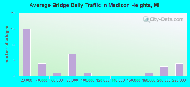
- 2,473,004Total average daily traffic
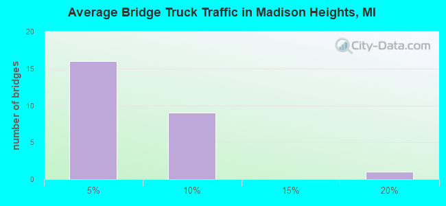
- 105,124Total average daily truck traffic
- National Bridge Inventory (NBI) Registered Bridges for Madison Heights
- No street view available for this location
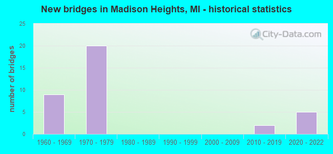
- New bridges - historical statistics
- 91960-1969
- 201970-1979
- 22010-2019
- 52020-2022
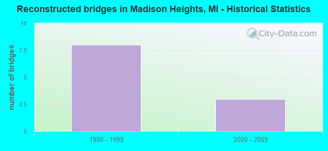
- Reconstructed bridges - Historical Statistics
- 81990-1999
- 32000-2009
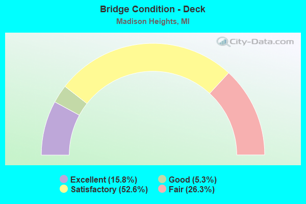
- Bridge Condition - Deck
- 15.8%Excellent
- 5.3%Good
- 52.6%Satisfactory
- 26.3%Fair
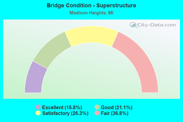
- Bridge Condition - Superstructure
- 15.8%Excellent
- 21.1%Good
- 26.3%Satisfactory
- 36.8%Fair

- Bridge Condition - Substructure
- 15.8%Excellent
- 36.8%Good
- 21.1%Satisfactory
- 26.3%Fair
Find on map >> Show street view
Structure Number: 797, Location: 1.0 MI N OF STEVENSVILLE (Lat: 42.033572, Lng: -86.510786), Route carried "on" structure: Ramp Interstate 94, Year Built: 1978, Status: Open, Structure Length: 5.70m (18.70ft), Average Daily Traffic: 3,500 (year 1995), Truck Traffic: 19%, Average Future Daily Traffic: 4,025 (year 2015), Design Load: HS 20, Features Intersected: CSX RR
Minimum Vertical Clearance: 30.48m (100.00ft), Kilometerpoint: 0.472, Lanes on structure: 1, Owner: State Highway Agency, Approaching Roadway Width: 8.8m (28.9ft), Skew: 4 degrees, Material/Design: Steel, Design/Construction: Stringer/Multi-beam, Number Of Spans In Main Unit: 3, Length of Maximum Span: 20.1m (65.9ft), Curb-To-Curb Width: 7.6m (24.9ft), Out-to-Out Width: 8.8m (28.9ft)
Condition: Deck: Fair, Superstructure: Fair, Substructure: Good, Operating Rating: 69.2 metric tons, Method Used To Determine Operating Rating: Load Factor (LF), Inventory Rating: 41.5 metric tons, Method Used To Determine Inventory Rating: Load Factor (LF), Structural Evaluation: Somewhat better than minimum adequacy, Deck Geometry: Better than present minimum criteria, Approach Roadway Alignment: Equal to present minimum criteria, Length Of Structure Improvement: 5.70m (18.70ft), Designated Inspection Frequency: Every 24 months, Inspection Date: August 2020, Bridge Improvement Cost: $128,000, Roadway Improvement Cost: $3,000, Total Project Cost: $38,000, Deck Structure Type: Concrete Cast-file-Place, Wearing Surface/Protective System: Wearing Surface: Monolithic Concrete
Find on map >> Show street view
Structure Number: 806, Location: 1.5 MI E OF HARBERT (Lat: 41.871097, Lng: -86.601869), Route carried "on" structure: County highway , Year Built: 1961, Year Reconstructed: 2013, Status: Open, Structure Length: 6.64m (21.78ft), Average Daily Traffic: 560 (year 2008), Truck Traffic: 3%, Average Future Daily Traffic: 566 (year 2012), Design Load: H 15, Features Intersected: I-94, Facility Carried by Structure: HARBERT ROAD
Minimum Vertical Clearance: 30.48m (100.00ft), Kilometerpoint: 3.636, Lanes on structure: 2, Lanes under structure: 6, Owner: State Highway Agency, Approaching Roadway Width: 6.9m (22.6ft), Skew: 1 degrees, Material/Design: Steel, Design/Construction: Stringer/Multi-beam, Number Of Spans In Main Unit: 4, Length of Maximum Span: 21.9m (71.9ft), Curb-To-Curb Width: 8.9m (29.2ft), Out-to-Out Width: 9.9m (32.5ft)
Condition: Deck: Satisfactory, Superstructure: Fair, Substructure: Good, Operating Rating: 54.1 metric tons, Method Used To Determine Operating Rating: Load Factor (LF) rating reported by rating factor (RF) method using MS18 loading, Inventory Rating: 32.4 metric tons, Method Used To Determine Inventory Rating: Load Factor (LF) rating reported by rating factor (RF) method using MS18 loading, Structural Evaluation: Somewhat better than minimum adequacy, Deck Geometry: Somewhat better than minimum adequacy, Underclear: High priority of corrective action, Approach Roadway Alignment: Equal to present desirable criteria, Designated Inspection Frequency: Every 24 months, Inspection Date: July 2020, Deck Structure Type: Concrete Cast-file-Place, Wearing Surface/Protective System: Wearing Surface: Latex Concrete
Find on map >> Show street view
Structure Number: 7968, Location: IN MADISON HTS (Lat: 42.476558, Lng: -83.108533), Route carried "on" structure: Ramp Interstate 696, Year Built: 1971, Status: Open, Structure Length: 2.51m (8.23ft), Average Daily Traffic: 6,800 (year 1982), Truck Traffic: 5%, Average Future Daily Traffic: 6,800 (year 2015), Design Load: HS 20, Features Intersected: N SERVICE RD
Minimum Vertical Clearance: 30.48m (100.00ft), Kilometerpoint: 0.547, Lanes on structure: 2, Lanes under structure: 2, Owner: State Highway Agency, Approaching Roadway Width: 15.8m (51.8ft), Skew: 3 degrees, Material/Design: Steel, Design/Construction: Stringer/Multi-beam, Number Of Spans In Main Unit: 1, Length of Maximum Span: 25.1m (82.3ft), Curb-To-Curb Width: 15.8m (51.8ft), Out-to-Out Width: 16.7m (54.8ft)
Condition: Deck: Fair, Superstructure: Satisfactory, Substructure: Good, Operating Rating: 97.2 metric tons, Method Used To Determine Operating Rating: Load Factor (LF) rating reported by rating factor (RF) method using MS18 loading, Inventory Rating: 63.2 metric tons, Method Used To Determine Inventory Rating: Load Factor (LF) rating reported by rating factor (RF) method using MS18 loading, Structural Evaluation: Equal to present minimum criteria, Deck Geometry: Superior to present desirable criteria, Underclear: Meets minimum limits, Approach Roadway Alignment: Equal to present desirable criteria, Designated Inspection Frequency: Every 24 months, Inspection Date: July 2021, Deck Structure Type: Concrete Cast-file-Place, Wearing Surface/Protective System: Wearing Surface: Latex Concrete
Find on map >> Show street view
Structure Number: 7969, Location: IN MADISON HTS (Lat: 42.476803, Lng: -83.108481), Route carried "on" structure: Interstate 696, Year Built: 1971, Year Reconstructed: 2007, Status: Open, Structure Length: 2.28m (7.48ft), Average Daily Traffic: 209,200 (year 2007), Truck Traffic: 4%, Average Future Daily Traffic: 222,094 (year 2018), Design Load: HS 20, Features Intersected: N SERVICE RD
Minimum Vertical Clearance: 30.48m (100.00ft), Kilometerpoint: 7.662, Lanes on structure: 8, Lanes under structure: 2, Base Highway Network: Yes (Inventory Route: 190, Subroute: 3), Owner: State Highway Agency, Approaching Roadway Width: 36.5m (119.8ft), Skew: 30 degrees, Material/Design: Steel, Design/Construction: Stringer/Multi-beam, Number Of Spans In Main Unit: 1, Length of Maximum Span: 22.8m (74.8ft), Curb or Sidewalk Widths: Left: 3.7m (12.1ft), Right: 3.7m (12.1ft), Curb-To-Curb Width: 48.1m (157.8ft), Out-to-Out Width: 48.8m (160.1ft)
Condition: Deck: Satisfactory, Superstructure: Good, Substructure: Good, Operating Rating: 93.3 metric tons, Method Used To Determine Operating Rating: Load Factor (LF) rating reported by rating factor (RF) method using MS18 loading, Inventory Rating: 56.1 metric tons, Method Used To Determine Inventory Rating: Load Factor (LF) rating reported by rating factor (RF) method using MS18 loading, Structural Evaluation: Better than present minimum criteria, Deck Geometry: Superior to present desirable criteria, Underclear: Better than present minimum criteria, Approach Roadway Alignment: Equal to present desirable criteria, Designated Inspection Frequency: Every 24 months, Inspection Date: July 2021, Deck Structure Type: Concrete Cast-file-Place, Wearing Surface/Protective System: Wearing Surface: Latex Concrete
Find on map >> Show street view
Structure Number: 797, Location: IN MADISON HTS (Lat: 42.477378, Lng: -83.108572), Route carried "on" structure: Ramp Interstate 696, Year Built: 1971, Year Reconstructed: 2007, Status: Open, Structure Length: 2.30m (7.55ft), Average Daily Traffic: 6,800 (year 1982), Truck Traffic: 5%, Average Future Daily Traffic: 7,820 (year 2002), Design Load: HS 20, Features Intersected: N SERVICE RD
Minimum Vertical Clearance: 30.48m (100.00ft), Kilometerpoint: 0.200, Lanes on structure: 2, Lanes under structure: 2, Owner: State Highway Agency, Approaching Roadway Width: 15.8m (51.8ft), Skew: 2 degrees, Material/Design: Steel, Design/Construction: Stringer/Multi-beam, Number Of Spans In Main Unit: 1, Length of Maximum Span: 23.0m (75.5ft), Curb or Sidewalk Widths: Left: 2.8m (9.2ft), Right: 1.0m (3.3ft), Curb-To-Curb Width: 8.4m (27.6ft), Out-to-Out Width: 13.5m (44.3ft)
Condition: Deck: Fair, Superstructure: Good, Substructure: Good, Operating Rating: 95.0 metric tons, Method Used To Determine Operating Rating: Load Factor (LF), Inventory Rating: 57.0 metric tons, Method Used To Determine Inventory Rating: Load Factor (LF), Structural Evaluation: Better than present minimum criteria, Deck Geometry: High priority of corrective action, Underclear: Somewhat better than minimum adequacy, Approach Roadway Alignment: Equal to present desirable criteria, Designated Inspection Frequency: Every 24 months, Inspection Date: July 2021, Deck Structure Type: Concrete Cast-file-Place, Wearing Surface/Protective System: Wearing Surface: Latex Concrete
Find on map >> Show street view
Structure Number: 7971, Location: IN MADISON HTS (Lat: 42.477014, Lng: -83.104722), Route carried "on" structure: City street 2059, Year Built: 1972, Year Reconstructed: 1997, Status: Open, Structure Length: 6.10m (20.01ft), Average Daily Traffic: 16,575 (year 1995), Truck Traffic: 3%, Average Future Daily Traffic: 19,330 (year 2015), Design Load: HS 20, Features Intersected: I-696, Facility Carried by Structure: JOHN R RD
Minimum Vertical Clearance: 30.48m (100.00ft), Kilometerpoint: 3.338, Lanes on structure: 4, Lanes under structure: 10, Owner: State Highway Agency, Approaching Roadway Width: 18.9m (62.0ft), Material/Design: Steel, Design/Construction: Stringer/Multi-beam, Number Of Spans In Main Unit: 2, Length of Maximum Span: 31.1m (102.0ft), Curb or Sidewalk Widths: Left: 2.4m (7.9ft), Right: 2.4m (7.9ft), Curb-To-Curb Width: 15.8m (51.8ft), Out-to-Out Width: 21.4m (70.2ft)
Condition: Deck: Satisfactory, Superstructure: Satisfactory, Substructure: Satisfactory, Operating Rating: 99.6 metric tons, Method Used To Determine Operating Rating: Load Factor (LF), Inventory Rating: 59.6 metric tons, Method Used To Determine Inventory Rating: Load Factor (LF), Structural Evaluation: Equal to present minimum criteria, Deck Geometry: Meets minimum limits, Underclear: Meets minimum limits, Approach Roadway Alignment: Equal to present desirable criteria, Designated Inspection Frequency: Every 24 months, Inspection Date: July 2020, Deck Structure Type: Concrete Cast-file-Place, Wearing Surface/Protective System: Wearing Surface: Monolithic Concrete, Deck Protection: Epoxy Coated Reinforcing
Find on map >> Show street view
Structure Number: 7972, Location: IN MADISON HTS (Lat: 42.477022, Lng: -83.103403), Route carried "on" structure: ServiceCity street , Year Built: 1972, Year Reconstructed: 1997, Status: Open, Structure Length: 5.97m (19.59ft), Average Daily Traffic: 4,800 (year 1995), Truck Traffic: 3%, Average Future Daily Traffic: 3,400 (year 1977), Design Load: HS 20, Features Intersected: I-696, Facility Carried by Structure: U-TURN @ BATTELLE
Minimum Vertical Clearance: 30.48m (100.00ft), Kilometerpoint: 0.035, Lanes on structure: 1, Lanes under structure: 10, Owner: State Highway Agency, Approaching Roadway Width: 6.1m (20.0ft), Material/Design: Steel, Design/Construction: Stringer/Multi-beam, Number Of Spans In Main Unit: 2, Length of Maximum Span: 29.8m (97.8ft), Curb-To-Curb Width: 6.1m (20.0ft), Out-to-Out Width: 7.1m (23.3ft)
Condition: Deck: Satisfactory, Superstructure: Fair, Substructure: Good, Operating Rating: 81.6 metric tons, Method Used To Determine Operating Rating: Load Factor (LF) rating reported by rating factor (RF) method using MS18 loading, Inventory Rating: 48.9 metric tons, Method Used To Determine Inventory Rating: Load Factor (LF) rating reported by rating factor (RF) method using MS18 loading, Structural Evaluation: Somewhat better than minimum adequacy, Deck Geometry: High priority of replacement, Underclear: Equal to present minimum criteria, Approach Roadway Alignment: Equal to present desirable criteria, Designated Inspection Frequency: Every 24 months, Inspection Date: July 2021, Deck Structure Type: Concrete Cast-file-Place, Wearing Surface/Protective System: Wearing Surface: Monolithic Concrete, Deck Protection: Epoxy Coated Reinforcing
Find on map >> Show street view
Structure Number: 7973, Location: IN MADISON HTS (Lat: 42.477289, Lng: -83.094664), Route carried "on" structure: City street , Year Built: 1972, Status: Open, Structure Length: 5.27m (17.29ft), Average Daily Traffic: 2,500 (year 1988), Average Future Daily Traffic: 1,050 (year 1977), Design Load: HS 20, Features Intersected: I-696, Facility Carried by Structure: COUZENS ST
Minimum Vertical Clearance: 30.48m (100.00ft), Kilometerpoint: 0.914, Lanes on structure: 4, Lanes under structure: 8, Owner: State Highway Agency, Approaching Roadway Width: 15.8m (51.8ft), Material/Design: Steel, Design/Construction: Stringer/Multi-beam, Number Of Spans In Main Unit: 2, Length of Maximum Span: 26.2m (86.0ft), Curb or Sidewalk Widths: Left: 1.8m (5.9ft), Right: 1.8m (5.9ft), Curb-To-Curb Width: 15.8m (51.8ft), Out-to-Out Width: 20.2m (66.3ft)
Condition: Deck: Satisfactory, Superstructure: Satisfactory, Substructure: Good, Operating Rating: 85.2 metric tons, Method Used To Determine Operating Rating: Load Factor (LF) rating reported by rating factor (RF) method using MS18 loading, Inventory Rating: 51.2 metric tons, Method Used To Determine Inventory Rating: Load Factor (LF) rating reported by rating factor (RF) method using MS18 loading, Structural Evaluation: Equal to present minimum criteria, Deck Geometry: Meets minimum limits, Underclear: Somewhat better than minimum adequacy, Approach Roadway Alignment: Equal to present desirable criteria, Designated Inspection Frequency: Every 24 months, Inspection Date: July 2021, Deck Structure Type: Concrete Cast-file-Place, Wearing Surface/Protective System: Wearing Surface: Latex Concrete
Find on map >> Show street view
Structure Number: 7974, Location: IN MADISON HTS (Lat: 42.477694, Lng: -83.090636), Route carried "on" structure: ServiceInterstate 696, Year Built: 1972, Year Reconstructed: 1997, Status: Open, Structure Length: 7.36m (24.15ft), Average Daily Traffic: 9,000 (year 1990), Truck Traffic: 3%, Average Future Daily Traffic: 6,500 (year 1991), Design Load: HS 20, Features Intersected: I-696, Facility Carried by Structure: 10 MI RD CONNECTOR
Minimum Vertical Clearance: 30.48m (100.00ft), Kilometerpoint: 0.240, Lanes on structure: 2, Lanes under structure: 8, Owner: State Highway Agency, Approaching Roadway Width: 10.6m (34.8ft), Skew: 9 degrees, Material/Design: Steel continuous, Design/Construction: Stringer/Multi-beam, Number Of Spans In Main Unit: 2, Length of Maximum Span: 42.3m (138.8ft), Curb or Sidewalk Widths: Left: 0.0m, Right: 1.8m (5.9ft), Curb-To-Curb Width: 8.9m (29.2ft), Out-to-Out Width: 11.6m (38.1ft)
Condition: Deck: Satisfactory, Superstructure: Fair, Substructure: Satisfactory, Operating Rating: 71.9 metric tons, Method Used To Determine Operating Rating: Load Factor (LF) rating reported by rating factor (RF) method using MS18 loading, Inventory Rating: 43.1 metric tons, Method Used To Determine Inventory Rating: Load Factor (LF) rating reported by rating factor (RF) method using MS18 loading, Structural Evaluation: Somewhat better than minimum adequacy, Deck Geometry: Meets minimum limits, Underclear: Somewhat better than minimum adequacy, Approach Roadway Alignment: Equal to present desirable criteria, Designated Inspection Frequency: Every 24 months, Inspection Date: July 2021, Deck Structure Type: Concrete Cast-file-Place, Wearing Surface/Protective System: Wearing Surface: Monolithic Concrete, Deck Protection: Epoxy Coated Reinforcing
Find on map >> Show street view
Structure Number: 7975, Location: IN MADISON HEIGHTS (Lat: 42.482131, Lng: -83.085983), Route carried "on" structure: County highway 2059, Year Built: 1972, Status: Open, Structure Length: 5.24m (17.19ft), Average Daily Traffic: 1,500 (year 2007), Truck Traffic: 3%, Average Future Daily Traffic: 1,650 (year 2022), Design Load: HS 20, Features Intersected: I-696, Facility Carried by Structure: DEQUINDRE LFT TRN
Minimum Vertical Clearance: 30.48m (100.00ft), Kilometerpoint: 0.058, Lanes on structure: 1, Lanes under structure: 8, Base Highway Network: Yes (Inventory Route: 181, Subroute: 4), Owner: State Highway Agency, Approaching Roadway Width: 5.4m (17.7ft), Material/Design: Steel, Design/Construction: Stringer/Multi-beam, Number Of Spans In Main Unit: 2, Length of Maximum Span: 26.2m (86.0ft), Curb or Sidewalk Widths: Left: 0.2m (0.7ft), Right: 0.7m (2.3ft), Curb-To-Curb Width: 5.7m (18.7ft), Out-to-Out Width: 7.2m (23.6ft)
Condition: Deck: Satisfactory, Superstructure: Good, Substructure: Satisfactory, Inventory Rating: 66.1 metric tons, Method Used To Determine Inventory Rating: Load Factor (LF), Structural Evaluation: Equal to present minimum criteria, Deck Geometry: High priority of replacement, Underclear: Somewhat better than minimum adequacy, Approach Roadway Alignment: Equal to present desirable criteria, Designated Inspection Frequency: Every 24 months, Inspection Date: July 2021, Deck Structure Type: Concrete Cast-file-Place, Wearing Surface/Protective System: Wearing Surface: Latex Concrete
Find on map >> Show street view
Structure Number: 7976, Location: IN WARREN & MADISON HTS (Lat: 42.483736, Lng: -83.084828), Route carried "on" structure: County highway 2058, Year Built: 1972, Status: Open, Structure Length: 9.48m (31.10ft), Average Daily Traffic: 18,500 (year 1974), Average Future Daily Traffic: 18,500 (year 1977), Design Load: HS 20, Features Intersected: I-696, Facility Carried by Structure: DEQUINDRE AVE
Minimum Vertical Clearance: 30.48m (100.00ft), Kilometerpoint: 4.080, Lanes on structure: 5, Lanes under structure: 8, Base Highway Network: Yes (Inventory Route: 79, Subroute: 2), Owner: State Highway Agency, Approaching Roadway Width: 19.8m (65.0ft), Skew: 6 degrees, Material/Design: Steel, Design/Construction: Stringer/Multi-beam, Number Of Spans In Main Unit: 2, Length of Maximum Span: 47.5m (155.8ft), Curb or Sidewalk Widths: Left: 1.8m (5.9ft), Right: 1.8m (5.9ft), Curb-To-Curb Width: 19.5m (64.0ft), Out-to-Out Width: 23.9m (78.4ft)
Condition: Deck: Satisfactory, Superstructure: Good, Substructure: Satisfactory, Operating Rating: 77.4 metric tons, Method Used To Determine Operating Rating: Load Factor (LF) rating reported by rating factor (RF) method using MS18 loading, Inventory Rating: 46.3 metric tons, Method Used To Determine Inventory Rating: Load Factor (LF) rating reported by rating factor (RF) method using MS18 loading, Structural Evaluation: Equal to present minimum criteria, Deck Geometry: Meets minimum limits, Underclear: High priority of corrective action, Approach Roadway Alignment: Equal to present desirable criteria, Designated Inspection Frequency: Every 24 months, Inspection Date: July 2021, Deck Structure Type: Concrete Cast-file-Place, Wearing Surface/Protective System: Wearing Surface: Latex Concrete
Find on map >> Show street view
Structure Number: 8041, Location: IN MADISON HTS (Lat: 42.506908, Lng: -83.114778), Route carried "on" structure: Interstate 75, Year Built: 1963, Year Reconstructed: 2001, Status: Open, Structure Length: 7.62m (25.00ft), Average Daily Traffic: 78,894 (year 2007), Truck Traffic: 5%, Average Future Daily Traffic: 81,730 (year 2018), Design Load: HS 20+Mod, Features Intersected: RED RUN DRAIN PATH
Minimum Vertical Clearance: 30.48m (100.00ft), Kilometerpoint: 7.297, Lanes on structure: 4, Base Highway Network: Yes (Inventory Route: 64, Subroute: 8), Owner: State Highway Agency, Approaching Roadway Width: 16.4m (53.8ft), Skew: 14 degrees, Material/Design: Steel, Design/Construction: Stringer/Multi-beam, Number Of Spans In Main Unit: 3, Length of Maximum Span: 26.5m (86.9ft), Curb or Sidewalk Widths: Left: 0.1m (0.3ft), Right: 0.7m (2.3ft), Curb-To-Curb Width: 17.6m (57.7ft), Out-to-Out Width: 18.1m (59.4ft)
Condition: Deck: Satisfactory, Superstructure: Satisfactory, Substructure: Fair, Operating Rating: 66.4 metric tons, Method Used To Determine Operating Rating: Load Factor (LF) rating reported by rating factor (RF) method using MS18 loading, Inventory Rating: 39.9 metric tons, Method Used To Determine Inventory Rating: Load Factor (LF) rating reported by rating factor (RF) method using MS18 loading, Structural Evaluation: Somewhat better than minimum adequacy, Deck Geometry: Meets minimum limits, Approach Roadway Alignment: Equal to present desirable criteria, Designated Inspection Frequency: Every 24 months, Other Special Inspection Frequency: Every 12 months, Inspection Date: July 2021, Other Special Inspection Date: July 2021, Deck Structure Type: Concrete Cast-file-Place, Wearing Surface/Protective System: Wearing Surface: Monolithic Concrete
Find on map >> Show street view
Structure Number: 8042, Location: IN MADISON HTS (Lat: 42.506753, Lng: -83.115072), Route carried "on" structure: Interstate 75, Year Built: 1963, Year Reconstructed: 2001, Status: Open, Structure Length: 7.62m (25.00ft), Average Daily Traffic: 78,894 (year 2007), Truck Traffic: 5%, Average Future Daily Traffic: 81,730 (year 2018), Design Load: HS 20+Mod, Features Intersected: RED RUN DRAIN PATH
Minimum Vertical Clearance: 30.48m (100.00ft), Kilometerpoint: 7.279, Lanes on structure: 3, Base Highway Network: Yes (Inventory Route: 64, Subroute: 6), Owner: State Highway Agency, Approaching Roadway Width: 16.4m (53.8ft), Skew: 14 degrees, Material/Design: Steel, Design/Construction: Stringer/Multi-beam, Number Of Spans In Main Unit: 3, Length of Maximum Span: 26.5m (86.9ft), Curb or Sidewalk Widths: Left: 0.7m (2.3ft), Right: 0.1m (0.3ft), Curb-To-Curb Width: 14.6m (47.9ft), Out-to-Out Width: 14.7m (48.2ft)
Condition: Deck: Good, Superstructure: Satisfactory, Substructure: Fair, Operating Rating: 71.9 metric tons, Method Used To Determine Operating Rating: Load Factor (LF) rating reported by rating factor (RF) method using MS18 loading, Inventory Rating: 43.1 metric tons, Method Used To Determine Inventory Rating: Load Factor (LF) rating reported by rating factor (RF) method using MS18 loading, Structural Evaluation: Somewhat better than minimum adequacy, Deck Geometry: Meets minimum limits, Approach Roadway Alignment: Equal to present desirable criteria, Designated Inspection Frequency: Every 24 months, Other Special Inspection Frequency: Every 12 months, Inspection Date: July 2021, Other Special Inspection Date: July 2021, Deck Structure Type: Concrete Cast-file-Place, Wearing Surface/Protective System: Wearing Surface: Monolithic Concrete
Find on map >> Show street view
Structure Number: 8058, Location: IN MADISON HTS (Lat: 42.504517, Lng: -83.114661), Route carried "on" structure: Interstate 75, Year Built: 1963, Year Reconstructed: 2001, Status: Open, Structure Length: 5.18m (16.99ft), Average Daily Traffic: 85,365 (year 2007), Truck Traffic: 5%, Average Future Daily Traffic: 81,730 (year 2018), Design Load: HS 20+Mod, Features Intersected: 12 MILE RD
Minimum Vertical Clearance: 30.48m (100.00ft), Kilometerpoint: 7.031, Lanes on structure: 4, Lanes under structure: 6, Base Highway Network: Yes (Inventory Route: 64, Subroute: 8), Owner: State Highway Agency, Approaching Roadway Width: 16.4m (53.8ft), Skew: 10 degrees, Material/Design: Prestressed concrete, Design/Construction: Stringer/Multi-beam, Number Of Spans In Main Unit: 4, Length of Maximum Span: 15.8m (51.8ft), Curb or Sidewalk Widths: Left: 0.1m (0.3ft), Right: 0.1m (0.3ft), Curb-To-Curb Width: 17.5m (57.4ft), Out-to-Out Width: 18.2m (59.7ft)
Condition: Deck: Fair, Superstructure: Fair, Substructure: Fair, Operating Rating: 68.9 metric tons, Method Used To Determine Operating Rating: Load Factor (LF), Inventory Rating: 41.3 metric tons, Method Used To Determine Inventory Rating: Load Factor (LF), Structural Evaluation: Somewhat better than minimum adequacy, Deck Geometry: Meets minimum limits, Underclear: Meets minimum limits, Approach Roadway Alignment: Equal to present desirable criteria, Designated Inspection Frequency: Every 24 months, Other Special Inspection Frequency: Every 12 months, Inspection Date: July 2021, Other Special Inspection Date: July 2021, Deck Structure Type: Concrete Cast-file-Place, Wearing Surface/Protective System: Wearing Surface: Latex Concrete
Find on map >> Show street view
Structure Number: 8059, Location: IN MADISON HTS (Lat: 42.504503, Lng: -83.115000), Route carried "on" structure: Interstate 75, Year Built: 1963, Year Reconstructed: 2001, Status: Open, Structure Length: 5.40m (17.72ft), Average Daily Traffic: 76,400 (year 2013), Truck Traffic: 4%, Average Future Daily Traffic: 87,860 (year 2033), Design Load: HS 20+Mod, Features Intersected: 12 MILE RD
Minimum Vertical Clearance: 30.48m (100.00ft), Kilometerpoint: 7.030, Lanes on structure: 3, Lanes under structure: 6, Base Highway Network: Yes (Inventory Route: 64, Subroute: 6), Owner: State Highway Agency, Approaching Roadway Width: 16.4m (53.8ft), Material/Design: Prestressed concrete, Design/Construction: Stringer/Multi-beam, Number Of Spans In Main Unit: 4, Length of Maximum Span: 16.4m (53.8ft), Curb-To-Curb Width: 17.2m (56.4ft), Out-to-Out Width: 18.3m (60.0ft)
Condition: Deck: Fair, Superstructure: Fair, Substructure: Fair, Operating Rating: 65.8 metric tons, Method Used To Determine Operating Rating: Load Factor (LF) rating reported by rating factor (RF) method using MS18 loading, Inventory Rating: 39.2 metric tons, Method Used To Determine Inventory Rating: Load Factor (LF) rating reported by rating factor (RF) method using MS18 loading, Structural Evaluation: Somewhat better than minimum adequacy, Deck Geometry: Better than present minimum criteria, Underclear: Meets minimum limits, Approach Roadway Alignment: Equal to present desirable criteria, Designated Inspection Frequency: Every 24 months, Other Special Inspection Frequency: Every 12 months, Inspection Date: July 2021, Other Special Inspection Date: July 2021, Deck Structure Type: Concrete Cast-file-Place, Wearing Surface/Protective System: Wearing Surface: Latex Concrete
Find on map >> Show street view
Structure Number: 806, Location: IN MADISON HTS (Lat: 42.519797, Lng: -83.115294), Route carried "on" structure: Interstate 75, Year Built: 1963, Year Reconstructed: 2001, Status: Open, Structure Length: 4.31m (14.14ft), Average Daily Traffic: 76,400 (year 2013), Truck Traffic: 4%, Average Future Daily Traffic: 87,860 (year 2033), Design Load: HS 20+Mod, Features Intersected: 13 MILE RD
Minimum Vertical Clearance: 30.48m (100.00ft), Kilometerpoint: 8.729, Lanes on structure: 3, Lanes under structure: 5, Base Highway Network: Yes (Inventory Route: 64, Subroute: 8), Owner: State Highway Agency, Approaching Roadway Width: 16.5m (54.1ft), Material/Design: Prestressed concrete, Design/Construction: Stringer/Multi-beam, Number Of Spans In Main Unit: 3, Length of Maximum Span: 19.4m (63.6ft), Curb-To-Curb Width: 17.2m (56.4ft), Out-to-Out Width: 18.2m (59.7ft)
Condition: Deck: Satisfactory, Superstructure: Fair, Substructure: Fair, Operating Rating: 50.9 metric tons, Method Used To Determine Operating Rating: Load Factor (LF) rating reported by rating factor (RF) method using MS18 loading, Inventory Rating: 30.5 metric tons, Method Used To Determine Inventory Rating: Load Factor (LF) rating reported by rating factor (RF) method using MS18 loading, Structural Evaluation: Somewhat better than minimum adequacy, Deck Geometry: Better than present minimum criteria, Underclear: High priority of corrective action, Approach Roadway Alignment: Equal to present desirable criteria, Designated Inspection Frequency: Every 24 months, Inspection Date: July 2021, Deck Structure Type: Concrete Cast-file-Place, Wearing Surface/Protective System: Wearing Surface: Monolithic Concrete
Find on map >> Show street view
Structure Number: 8061, Location: IN MADISON HTS (Lat: 42.519792, Lng: -83.115611), Route carried "on" structure: Interstate 75, Year Built: 2021, Status: Open, Structure Length: 3.40m (11.15ft), Average Daily Traffic: 76,400 (year 2013), Truck Traffic: 4%, Average Future Daily Traffic: 87,860 (year 2033), Design Load: Greater than HL93, Features Intersected: 13 MILE RD
Minimum Vertical Clearance: 30.48m (100.00ft), Kilometerpoint: 8.728, Lanes on structure: 4, Lanes under structure: 5, Base Highway Network: Yes (Inventory Route: 64, Subroute: 6), Owner: State Highway Agency, Approaching Roadway Width: 16.5m (54.1ft), Material/Design: Prestressed concrete, Design/Construction: Stringer/Multi-beam, Number Of Spans In Main Unit: 1, Length of Maximum Span: 32.7m (107.3ft), Curb-To-Curb Width: 21.5m (70.5ft), Out-to-Out Width: 22.5m (73.8ft)
Condition: Deck: Excellent, Superstructure: Excellent, Substructure: Excellent, Operating Rating: 58.3 metric tons, Method Used To Determine Operating Rating: Load and Resistance Factor Rating (LRFR) rating reported by rating factor(RF) method using HL-93 loadings, Inventory Rating: 37.3 metric tons, Method Used To Determine Inventory Rating: Load and Resistance Factor Rating (LRFR) rating reported by rating factor(RF) method using HL-93 loadings, Structural Evaluation: Superior to present desirable criteria, Deck Geometry: Better than present minimum criteria, Underclear: High priority of corrective action, Approach Roadway Alignment: Equal to present desirable criteria, Designated Inspection Frequency: Every 24 months, Inspection Date: July 2021, Deck Structure Type: Concrete Cast-file-Place, Wearing Surface/Protective System: Wearing Surface: Monolithic Concrete, Deck Protection: Epoxy Coated Reinforcing
Find on map >> Show street view
Structure Number: 8062, Location: N LTS OF MADISON HTS (Lat: 42.533936, Lng: -83.115925), Route carried "on" structure: Interstate 75, Year Built: 2019, Status: Open, Structure Length: 4.75m (15.58ft), Average Daily Traffic: 76,400 (year 2013), Truck Traffic: 4%, Average Future Daily Traffic: 87,860 (year 2033), Design Load: Greater than HL93, Features Intersected: 14 MILE RD
Minimum Vertical Clearance: 30.48m (100.00ft), Kilometerpoint: 10.300, Lanes on structure: 4, Lanes under structure: 7, Base Highway Network: Yes (Inventory Route: 64, Subroute: 8), Owner: State Highway Agency, Approaching Roadway Width: 21.5m (70.5ft), Material/Design: Prestressed concrete, Design/Construction: Stringer/Multi-beam, Number Of Spans In Main Unit: 1, Length of Maximum Span: 46.5m (152.6ft), Curb-To-Curb Width: 21.5m (70.5ft), Out-to-Out Width: 22.5m (73.8ft)
Condition: Deck: Excellent, Superstructure: Excellent, Substructure: Excellent, Operating Rating: 77.8 metric tons, Method Used To Determine Operating Rating: Load and Resistance Factor Rating (LRFR) rating reported by rating factor(RF) method using HL-93 loadings, Inventory Rating: 38.2 metric tons, Method Used To Determine Inventory Rating: Load and Resistance Factor Rating (LRFR) rating reported by rating factor(RF) method using HL-93 loadings, Structural Evaluation: Superior to present desirable criteria, Deck Geometry: Better than present minimum criteria, Underclear: Meets minimum limits, Approach Roadway Alignment: Equal to present desirable criteria, Length Of Structure Improvement: 4.76m (15.62ft), Designated Inspection Frequency: Every 24 months, Inspection Date: December 2021, Bridge Improvement Cost: $323,000, Roadway Improvement Cost: $26,000, Total Project Cost: $305,000, Deck Structure Type: Concrete Cast-file-Place, Wearing Surface/Protective System: Wearing Surface: Monolithic Concrete, Deck Protection: Epoxy Coated Reinforcing
Find on map >> Show street view
Structure Number: 8063, Location: N LTS OF MADISON HTS (Lat: 42.533928, Lng: -83.116253), Route carried "on" structure: Interstate 75, Year Built: 2020, Status: Open, Structure Length: 4.75m (15.58ft), Average Daily Traffic: 79,250 (year 2016), Truck Traffic: 8%, Average Future Daily Traffic: 96,100 (year 2038), Design Load: Greater than HL93, Features Intersected: 14 MILE RD
Minimum Vertical Clearance: 30.48m (100.00ft), Kilometerpoint: 10.299, Lanes on structure: 4, Lanes under structure: 6, Base Highway Network: Yes (Inventory Route: 64, Subroute: 6), Owner: State Highway Agency, Approaching Roadway Width: 21.5m (70.5ft), Material/Design: Prestressed concrete, Design/Construction: Stringer/Multi-beam, Number Of Spans In Main Unit: 1, Length of Maximum Span: 46.5m (152.6ft), Curb-To-Curb Width: 21.5m (70.5ft), Out-to-Out Width: 22.5m (73.8ft)
Condition: Deck: Excellent, Superstructure: Excellent, Substructure: Excellent, Operating Rating: 77.8 metric tons, Method Used To Determine Operating Rating: Load and Resistance Factor Rating (LRFR) rating reported by rating factor(RF) method using HL-93 loadings, Inventory Rating: 38.2 metric tons, Method Used To Determine Inventory Rating: Load and Resistance Factor Rating (LRFR) rating reported by rating factor(RF) method using HL-93 loadings, Structural Evaluation: Superior to present desirable criteria, Deck Geometry: Better than present minimum criteria, Underclear: Meets minimum limits, Approach Roadway Alignment: Equal to present desirable criteria, Length Of Structure Improvement: 4.76m (15.62ft), Designated Inspection Frequency: Every 24 months, Inspection Date: December 2021, Bridge Improvement Cost: $323,000, Roadway Improvement Cost: $26,000, Total Project Cost: $305,000, Deck Structure Type: Concrete Cast-file-Place, Wearing Surface/Protective System: Wearing Surface: Monolithic Concrete, Deck Protection: Epoxy Coated Reinforcing
Find on map >> Show street view
Structure Number: 12847, Location: 0.1 MI N OF CHICAGO RD (Lat: 42.524325, Lng: -83.086411), Route carried "on" structure: County highway 2058, Year Built: 1970, Status: Open, Structure Length: 3.96m (12.99ft), Average Daily Traffic: 26,740 (year 2010), Truck Traffic: 3%, Average Future Daily Traffic: 32,623 (year 2030), Design Load: HS 20, Features Intersected: RED RUN DRAIN, Facility Carried by Structure: DEQUINDRE RD
Minimum Vertical Clearance: 30.48m (100.00ft), Kilometerpoint: 8.654, Lanes on structure: 5, Base Highway Network: Yes (Inventory Route: 79, Subroute: 2), Owner: County Highway Agency, Approaching Roadway Width: 17.0m (55.8ft), Skew: 3 degrees, Material/Design: Concrete, Design/Construction: Culvert, Number Of Spans In Main Unit: 5, Length of Maximum Span: 8.5m (27.9ft)
Condition: Channel: Very good, Culverts: Good, Operating Rating: 59.1 metric tons, Method Used To Determine Operating Rating: Field evaluation and documented engineering judgment, Inventory Rating: 35.4 metric tons, Method Used To Determine Inventory Rating: Field evaluation and documented engineering judgment, Structural Evaluation: Better than present minimum criteria, Waterway Adequacy: Superior to present desirable criteria, Approach Roadway Alignment: Equal to present desirable criteria, Designated Inspection Frequency: Every 24 months, Inspection Date: July 2020
Find on map >> Show street view
Structure Number: 7968, Location: IN MADISON HTS (Lat: 42.476558, Lng: -83.108533), Route carried "under" structure: ServiceCity street 63, Year Built: 1971, Structure Length: 0. m, Average Daily Traffic: 8,800 (year 0000), Features Intersected: N SERVICE RD, Facility Carried by Structure: I-696 RAMPS AF&EF
Minimum Vertical Clearance: 4.32m (14.17ft), Kilometerpoint: 3.848, Lanes on structure: 2, Lanes under structure: 2, Material/Design: Steel, Design/Construction: Stringer/Multi-beam, Length of Maximum Span: 25.1m (82.3ft)
Find on map >> Show street view
Structure Number: 7969, Location: IN MADISON HTS (Lat: 42.476803, Lng: -83.108481), Route carried "under" structure: ServiceInterstate 696, Year Built: 1971, Structure Length: 0. m, Average Daily Traffic: 8,800 (year 1977), Features Intersected: N SERVICE RD
Minimum Vertical Clearance: 6.48m (21.26ft), Kilometerpoint: 3.875, Lanes on structure: 8, Lanes under structure: 2, Material/Design: Steel, Design/Construction: Stringer/Multi-beam, Length of Maximum Span: 22.8m (74.8ft)
Find on map >> Show street view
Structure Number: 797, Location: IN MADISON HTS (Lat: 42.477378, Lng: -83.108572), Route carried "under" structure: ServiceCity street 2000, Year Built: 1971, Structure Length: 0. m, Average Daily Traffic: 8,800 (year 0000), Features Intersected: N SERVICE RD, Facility Carried by Structure: I-696 RAMPS GH&GD
Minimum Vertical Clearance: 4.47m (14.67ft), Kilometerpoint: 3.941, Lanes on structure: 2, Lanes under structure: 2, Material/Design: Steel, Design/Construction: Stringer/Multi-beam, Length of Maximum Span: 23.0m (75.5ft)
Find on map >> Show street view
Structure Number: 7971, Location: IN MADISON HTS (Lat: 42.477014, Lng: -83.104722), Route carried "under" structure: Interstate 696, Year Built: 1972, Structure Length: 0. m, Average Daily Traffic: 209,200 (year 2007), Truck Traffic: 4%, Features Intersected: I-696, Facility Carried by Structure: JOHN R RD
Minimum Vertical Clearance: 5.56m (18.24ft), Kilometerpoint: 7.973, Lanes on structure: 4, Lanes under structure: 10, Material/Design: Steel, Design/Construction: Stringer/Multi-beam, Length of Maximum Span: 31.1m (102.0ft)
Find on map >> Show street view
Structure Number: 7972, Location: IN MADISON HTS (Lat: 42.477022, Lng: -83.103403), Route carried "under" structure: Interstate 696, Year Built: 1972, Structure Length: 0. m, Average Daily Traffic: 209,200 (year 2007), Truck Traffic: 4%, Features Intersected: I-696, Facility Carried by Structure: U-TURN @ BATTELLE
Minimum Vertical Clearance: 5.49m (18.01ft), Kilometerpoint: 8.081, Lanes on structure: 1, Lanes under structure: 10, Material/Design: Steel, Design/Construction: Stringer/Multi-beam, Length of Maximum Span: 29.8m (97.8ft)
Find on map >> Show street view
Structure Number: 7973, Location: IN MADISON HTS (Lat: 42.477289, Lng: -83.094664), Route carried "under" structure: Interstate 696, Year Built: 1972, Structure Length: 0. m, Average Daily Traffic: 209,200 (year 2007), Truck Traffic: 4%, Features Intersected: I-696, Facility Carried by Structure: COUZENS ST
Minimum Vertical Clearance: 5.11m (16.77ft), Kilometerpoint: 8.800, Lanes on structure: 4, Lanes under structure: 8, Material/Design: Steel, Design/Construction: Stringer/Multi-beam, Length of Maximum Span: 26.2m (86.0ft)
Find on map >> Show street view
Structure Number: 7974, Location: IN MADISON HTS (Lat: 42.477694, Lng: -83.090636), Route carried "under" structure: Interstate 696, Year Built: 1972, Structure Length: 0. m, Average Daily Traffic: 189,132 (year 2007), Truck Traffic: 4%, Features Intersected: I-696, Facility Carried by Structure: 10 MI RD CONNECTOR
Minimum Vertical Clearance: 5.51m (18.08ft), Kilometerpoint: 9.143, Lanes on structure: 2, Lanes under structure: 8, Material/Design: Steel continuous, Design/Construction: Stringer/Multi-beam, Length of Maximum Span: 42.3m (138.8ft)
Find on map >> Show street view
Structure Number: 7975, Location: IN MADISON HEIGHTS (Lat: 42.482131, Lng: -83.085983), Route carried "under" structure: Interstate 696, Year Built: 1972, Structure Length: 0. m, Average Daily Traffic: 189,132 (year 2007), Truck Traffic: 4%, Features Intersected: I-696, Facility Carried by Structure: DEQUINDRE LFT TRN
Minimum Vertical Clearance: 5.11m (16.77ft), Kilometerpoint: 9.780, Lanes on structure: 1, Lanes under structure: 8, Material/Design: Steel, Design/Construction: Stringer/Multi-beam, Length of Maximum Span: 26.2m (86.0ft)
Find on map >> Show street view
Structure Number: 7976, Location: IN WARREN & MADISON HTS (Lat: 42.483736, Lng: -83.084828), Route carried "under" structure: Interstate 696, Year Built: 1972, Structure Length: 0. m, Average Daily Traffic: 189,132 (year 2007), Truck Traffic: 6%, Features Intersected: I-696, Facility Carried by Structure: DEQUINDRE AVE
Minimum Vertical Clearance: 5.21m (17.09ft), Kilometerpoint: 9.981, Lanes on structure: 5, Lanes under structure: 8, Material/Design: Steel, Design/Construction: Stringer/Multi-beam, Length of Maximum Span: 47.5m (155.8ft)
Find on map >> Show street view
Structure Number: 8049, Location: IN MADISON HTS (Lat: 42.501919, Lng: -83.115608), Route carried "under" structure: Interstate 75, Year Built: 2021, Structure Length: 0. m, Average Daily Traffic: 170,730 (year 2007), Truck Traffic: 5%, Features Intersected: I-75, Facility Carried by Structure: 12 MI RD WALKOVER
Minimum Vertical Clearance: 5.79m (19.00ft), Kilometerpoint: 6.732, Lanes under structure: 10, Material/Design: Prestressed concrete, Design/Construction: Stringer/Multi-beam, Length of Maximum Span: 34.9m (114.5ft)
Find on map >> Show street view
Structure Number: 8058, Location: IN MADISON HTS (Lat: 42.504517, Lng: -83.114661), Route carried "under" structure: County highway 2059, Year Built: 1963, Structure Length: 0. m, Average Daily Traffic: 22,420 (year 1995), Features Intersected: 12 MILE RD, Facility Carried by Structure: I-75 NB
Minimum Vertical Clearance: 5.36m (17.59ft), Kilometerpoint: 33.041, Lanes on structure: 4, Lanes under structure: 6, Material/Design: Prestressed concrete, Design/Construction: Stringer/Multi-beam, Length of Maximum Span: 15.8m (51.8ft)
Find on map >> Show street view
Structure Number: 8059, Location: IN MADISON HTS (Lat: 42.504503, Lng: -83.115000), Route carried "under" structure: County highway 2059, Year Built: 1963, Structure Length: 0. m, Average Daily Traffic: 22,420 (year 1974), Features Intersected: 12 MILE RD, Facility Carried by Structure: I-75 SB
Minimum Vertical Clearance: 5.61m (18.41ft), Kilometerpoint: 33.014, Lanes on structure: 3, Lanes under structure: 6, Material/Design: Prestressed concrete, Design/Construction: Stringer/Multi-beam, Length of Maximum Span: 16.4m (53.8ft)
Find on map >> Show street view
Structure Number: 806, Location: IN MADISON HTS (Lat: 42.519797, Lng: -83.115294), Route carried "under" structure: City street 2059, Year Built: 1963, Structure Length: 0. m, Average Daily Traffic: 14,370 (year 1974), Features Intersected: 13 MILE RD, Facility Carried by Structure: I-75 NB
Minimum Vertical Clearance: 4.98m (16.34ft), Kilometerpoint: 2.392, Lanes on structure: 3, Lanes under structure: 5, Material/Design: Prestressed concrete, Design/Construction: Stringer/Multi-beam, Length of Maximum Span: 19.4m (63.6ft)
Find on map >> Show street view
Structure Number: 8061, Location: IN MADISON HTS (Lat: 42.519792, Lng: -83.115611), Route carried "under" structure: City street 2059, Year Built: 2021, Structure Length: 0. m, Average Daily Traffic: 14,370 (year 1974), Features Intersected: 13 MILE RD, Facility Carried by Structure: I-75 SB
Minimum Vertical Clearance: 4.90m (16.08ft), Kilometerpoint: 2.417, Lanes on structure: 4, Lanes under structure: 5, Material/Design: Prestressed concrete, Design/Construction: Stringer/Multi-beam, Length of Maximum Span: 32.7m (107.3ft)
Find on map >> Show street view
Structure Number: 8062, Location: N LTS OF MADISON HTS (Lat: 42.533936, Lng: -83.115925), Route carried "under" structure: County highway 2059, Year Built: 2019, Structure Length: 0. m, Average Daily Traffic: 32,820 (year 2013), Features Intersected: 14 MILE RD, Facility Carried by Structure: I-75 NB
Minimum Vertical Clearance: 5.05m (16.57ft), Kilometerpoint: 2.388, Lanes on structure: 4, Lanes under structure: 7, Material/Design: Prestressed concrete, Design/Construction: Stringer/Multi-beam, Length of Maximum Span: 46.5m (152.6ft)
Find on map >> Show street view
Structure Number: 8063, Location: N LTS OF MADISON HTS (Lat: 42.533928, Lng: -83.116253), Route carried "under" structure: County highway 2059, Year Built: 2020, Structure Length: 0. m, Average Daily Traffic: 40,000 (year 2016), Truck Traffic: 7%, Features Intersected: 14 MILE RD, Facility Carried by Structure: I-75 SB
Minimum Vertical Clearance: 5.05m (16.57ft), Kilometerpoint: 2.416, Lanes on structure: 4, Lanes under structure: 6, Material/Design: Prestressed concrete, Design/Construction: Stringer/Multi-beam, Length of Maximum Span: 46.5m (152.6ft)