Bridge Statistics for Madison, Georgia (GA)
Condition, Traffic, Stress, Structural Evaluation, Project Costs
- National Bridge Inventory (NBI) Statistics
- 43Number of bridges
- 479ft / 146mTotal length
- $489,120,000Total costs
- 494,516Total average daily traffic
- 43,750Total average daily truck traffic
- National Bridge Inventory (NBI) Registered Bridges for Madison
- No street view available for this location
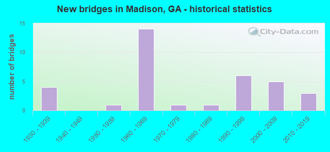
- New bridges - historical statistics
- 41930-1939
- 11950-1959
- 141960-1969
- 11970-1979
- 11980-1989
- 61990-1999
- 52000-2009
- 32010-2019

- Reconstructed bridges - Historical Statistics
- 21960-1969
- 01970-1979
- 01980-1989
- 11990-1999


- Bridge Condition - Deck
- 78.3%Good
- 17.4%Satisfactory
- 4.3%Fair

- Bridge Condition - Superstructure
- 26.1%Very good
- 52.2%Good
- 21.7%Satisfactory

- Bridge Condition - Substructure
- 17.4%Very good
- 52.2%Good
- 21.7%Satisfactory
- 8.7%Fair

- Bridge Condition - Channel
- 34.6%Very good
- 7.7%Good
- 38.5%Satisfactory
- 19.2%Fair

- Bridge Condition - Culverts
- 58.3%Good
- 41.7%Satisfactory
Find on map >> Show street view
Structure Number: 2110001, Location: 2 MI NE OF MADISON (Lat: 33.612747, Lng: -83.443808), Route carried "on" structure: US 278, Year Built: 1959, Status: Open, Structure Length: 7.77m (25.49ft), Average Daily Traffic: 3,140 (year 2010), Truck Traffic: 3%, Average Future Daily Traffic: 4,710 (year 2030), Design Load: HS 20, Features Intersected: CSX RAILROAD (279602P)
Minimum Vertical Clearance: 30+ m (98+ ft), Kilometerpoint: 22.531, Lanes on structure: 2, Base Highway Network: Yes, Owner: State Highway Agency, Approaching Roadway Width: 9.4m (30.8ft), Skew: 6 degrees, Material/Design: Steel, Design/Construction: Stringer/Multi-beam, Number Of Spans In Main Unit: 7, Length of Maximum Span: 18.3m (60.0ft), Curb or Sidewalk Widths: Left: 0.6m (2.0ft), Right: 0.6m (2.0ft), Curb-To-Curb Width: 8.5m (27.9ft), Out-to-Out Width: 10.5m (34.4ft)
Condition: Deck: Fair, Superstructure: Satisfactory, Substructure: Fair, Operating Rating: 31.7 metric tons, Method Used To Determine Operating Rating: Load Factor (LF), Inventory Rating: 19.0 metric tons, Method Used To Determine Inventory Rating: Load Factor (LF), Structural Evaluation: Somewhat better than minimum adequacy, Deck Geometry: Meets minimum limits, Underclear: Somewhat better than minimum adequacy, Approach Roadway Alignment: Somewhat better than minimum adequacy, Designated Inspection Frequency: Every 24 months, Inspection Date: August 2020, Bridge Improvement Cost: $996,000, Roadway Improvement Cost: $100,000, Total Project Cost: $1,495,000, Deck Structure Type: Concrete Cast-file-Place
Find on map >> Show street view
Structure Number: 2110004, Location: 1.5 MI NE OF MADISON (Lat: 33.611258, Lng: -83.449889), Route carried "on" structure: US 129, Year Built: 1986, Status: Open, Structure Length: 7.71m (25.30ft), Average Daily Traffic: 8,910 (year 2010), Truck Traffic: 6%, Average Future Daily Traffic: 13,365 (year 2030), Design Load: HS 20+Mod, Features Intersected: CSX RR- NOR-SOU RR
Minimum Vertical Clearance: 30+ m (98+ ft), Kilometerpoint: 20.921, Lanes on structure: 4, Base Highway Network: Yes, Owner: State Highway Agency, Approaching Roadway Width: 9.1m (29.9ft), Skew: 4 degrees, Material/Design: Prestressed concrete, Design/Construction: Stringer/Multi-beam, Number Of Spans In Main Unit: 4, Length of Maximum Span: 19.5m (64.0ft), Curb-To-Curb Width: 20.7m (67.9ft), Out-to-Out Width: 21.7m (71.2ft)
Condition: Deck: Satisfactory, Superstructure: Good, Substructure: Good, Operating Rating: 69.8 metric tons, Method Used To Determine Operating Rating: Load Factor (LF), Inventory Rating: 39.9 metric tons, Method Used To Determine Inventory Rating: Load Factor (LF), Structural Evaluation: Better than present minimum criteria, Deck Geometry: Superior to present desirable criteria, Underclear: Somewhat better than minimum adequacy, Approach Roadway Alignment: Equal to present desirable criteria, Designated Inspection Frequency: Every 24 months, Inspection Date: August 2020, Bridge Improvement Cost: $1,528,000, Roadway Improvement Cost: $153,000, Total Project Cost: $2,292,000, Deck Structure Type: Concrete Cast-file-Place
Find on map >> Show street view
Structure Number: 2110005, Location: 3.5 MI N OF MADISON (Lat: 33.644647, Lng: -83.448047), Route carried "on" structure: US 129, Year Built: 1932, Year Reconstructed: 1968, Status: Open, Structure Length: 9.14m (29.99ft), Average Daily Traffic: 8,910 (year 2010), Truck Traffic: 12%, Average Future Daily Traffic: 13,365 (year 2030), Design Load: H 15, Features Intersected: HARD LABOR CREEK
Minimum Vertical Clearance: 30+ m (98+ ft), Kilometerpoint: 25.750, Lanes on structure: 2, Base Highway Network: Yes, Owner: State Highway Agency, Approaching Roadway Width: 9.8m (32.2ft), Material/Design: Concrete, Design/Construction: Tee Beam, Number Of Spans In Main Unit: 10, Length of Maximum Span: 9.1m (29.9ft), Curb or Sidewalk Widths: Left: 0.6m (2.0ft), Right: 0.6m (2.0ft), Curb-To-Curb Width: 8.5m (27.9ft), Out-to-Out Width: 10.6m (34.8ft)
Condition: Deck: Satisfactory, Superstructure: Satisfactory, Substructure: Satisfactory, Channel: Satisfactory, Operating Rating: 29.0 metric tons, Method Used To Determine Operating Rating: Load Factor (LF), Inventory Rating: 17.2 metric tons, Method Used To Determine Inventory Rating: Load Factor (LF), Structural Evaluation: Meets minimum limits, Deck Geometry: Meets minimum limits, Waterway Adequacy: Equal to present desirable criteria, Approach Roadway Alignment: Equal to present desirable criteria, Length Of Structure Improvement: 15.58m (51.12ft), Designated Inspection Frequency: Every 24 months, Inspection Date: August 2020, Bridge Improvement Cost: $1,172,000, Roadway Improvement Cost: $117,000, Total Project Cost: $1,758,000, Deck Structure Type: Concrete Cast-file-Place, Wearing Surface/Protective System: Wearing Surface: Bituminous
Find on map >> Show street view
Structure Number: 2110006, Location: 1.5 MI SW OF APALACHEE (Lat: 33.667278, Lng: -83.444628), Route carried "on" structure: US 129, Year Built: 1932, Year Reconstructed: 1968, Status: Open, Structure Length: 9.57m (31.40ft), Average Daily Traffic: 8,380 (year 2010), Truck Traffic: 12%, Average Future Daily Traffic: 12,570 (year 2030), Design Load: H 15, Features Intersected: BIG SANDY CREEK
Minimum Vertical Clearance: 30+ m (98+ ft), Kilometerpoint: 27.359, Lanes on structure: 2, Base Highway Network: Yes, Owner: State Highway Agency, Approaching Roadway Width: 9.8m (32.2ft), Skew: 1 degrees, Material/Design: Concrete, Design/Construction: Tee Beam, Number Of Spans In Main Unit: 10, Length of Maximum Span: 15.8m (51.8ft), Curb or Sidewalk Widths: Left: 0.6m (2.0ft), Right: 0.6m (2.0ft), Curb-To-Curb Width: 8.5m (27.9ft), Out-to-Out Width: 10.6m (34.8ft)
Condition: Deck: Satisfactory, Superstructure: Satisfactory, Substructure: Fair, Channel: Satisfactory, Operating Rating: 33.5 metric tons, Method Used To Determine Operating Rating: Load Factor (LF), Inventory Rating: 19.9 metric tons, Method Used To Determine Inventory Rating: Load Factor (LF), Structural Evaluation: Somewhat better than minimum adequacy, Deck Geometry: Meets minimum limits, Waterway Adequacy: Equal to present minimum criteria, Approach Roadway Alignment: Equal to present desirable criteria, Designated Inspection Frequency: Every 24 months, Underwater Inspection Frequency: Every 60 months, Inspection Date: August 2020, Underwater Inspection Date: August 2019, Bridge Improvement Cost: $1,227,000, Roadway Improvement Cost: $123,000, Total Project Cost: $1,840,000, Deck Structure Type: Concrete Cast-file-Place, Wearing Surface/Protective System: Wearing Surface: Bituminous
Find on map >> Show street view
Structure Number: 2110011, Location: 5.7 MI SW OF MADISON (Lat: 33.525539, Lng: -83.523958), Route carried "on" structure: State highway 83, Year Built: 1963, Status: Open, Structure Length: 4.57m (14.99ft), Average Daily Traffic: 2,470 (year 2011), Truck Traffic: 1%, Average Future Daily Traffic: 3,705 (year 2031), Design Load: HS 20+Mod, Features Intersected: BIG INDIAN CREEK, Facility Carried by Structure: MONTICELLO HIGHWAY
Minimum Vertical Clearance: 30+ m (98+ ft), Kilometerpoint: 11.265, Lanes on structure: 2, Base Highway Network: Yes, Owner: State Highway Agency, Approaching Roadway Width: 7.6m (24.9ft), Material/Design: Concrete, Design/Construction: Tee Beam, Number Of Spans In Main Unit: 5, Length of Maximum Span: 9.1m (29.9ft), Curb or Sidewalk Widths: Left: 0.6m (2.0ft), Right: 0.6m (2.0ft), Curb-To-Curb Width: 8.5m (27.9ft), Out-to-Out Width: 10.4m (34.1ft)
Condition: Deck: Good, Superstructure: Good, Substructure: Satisfactory, Channel: Fair, Operating Rating: 57.1 metric tons, Method Used To Determine Operating Rating: Load Factor (LF), Inventory Rating: 34.4 metric tons, Method Used To Determine Inventory Rating: Load Factor (LF), Structural Evaluation: Equal to present minimum criteria, Deck Geometry: Meets minimum limits, Waterway Adequacy: Equal to present desirable criteria, Approach Roadway Alignment: Equal to present desirable criteria, Designated Inspection Frequency: Every 24 months, Inspection Date: September 2020, Bridge Improvement Cost: $586,000, Roadway Improvement Cost: $59,000, Total Project Cost: $879,000, Deck Structure Type: Concrete Cast-file-Place
Find on map >> Show street view
Structure Number: 2110012, Location: 4.3 MI SW OF MADISON (Lat: 33.543719, Lng: -83.510039), Route carried "on" structure: State highway 83, Year Built: 1930, Status: Open, Structure Length: 0.64m (2.10ft), Average Daily Traffic: 3,100 (year 2010), Truck Traffic: 5%, Average Future Daily Traffic: 4,650 (year 2030), Design Load: H 15, Features Intersected: LITTLE INDIAN CREEK, Facility Carried by Structure: MONTICELLO HIGHWAY
Minimum Vertical Clearance: 30+ m (98+ ft), Kilometerpoint: 12.875, Lanes on structure: 2, Base Highway Network: Yes, Owner: State Highway Agency, Approaching Roadway Width: 8.5m (27.9ft), Material/Design: Concrete, Design/Construction: Culvert, Number Of Spans In Main Unit: 2, Length of Maximum Span: 3.0m (9.8ft)
Condition: Channel: Satisfactory, Culverts: Good, Operating Rating: 55.3 metric tons, Method Used To Determine Operating Rating: Load Factor (LF), Inventory Rating: 32.6 metric tons, Method Used To Determine Inventory Rating: Load Factor (LF), Structural Evaluation: Better than present minimum criteria, Waterway Adequacy: Equal to present desirable criteria, Approach Roadway Alignment: Equal to present desirable criteria, Designated Inspection Frequency: Every 24 months, Inspection Date: September 2020, Bridge Improvement Cost: $82,000, Roadway Improvement Cost: $8,000, Total Project Cost: $123,000
Find on map >> Show street view
Structure Number: 2110014, Location: 1.2 MI NW OF MADISON (Lat: 33.610539, Lng: -83.478669), Route carried "on" structure: State highway 83, Year Built: 1937, Year Reconstructed: 1998, Status: Open, Structure Length: 0.64m (2.10ft), Average Daily Traffic: 4,420 (year 2010), Truck Traffic: 5%, Average Future Daily Traffic: 6,630 (year 2030), Design Load: H 15, Features Intersected: MILE BRANCH, Facility Carried by Structure: BOSTWICK HIGHWAY
Minimum Vertical Clearance: 30+ m (98+ ft), Kilometerpoint: 22.531, Lanes on structure: 2, Base Highway Network: Yes, Owner: State Highway Agency, Approaching Roadway Width: 7.3m (24.0ft), Material/Design: Concrete, Design/Construction: Culvert, Number Of Spans In Main Unit: 2, Length of Maximum Span: 3.0m (9.8ft)
Condition: Channel: Satisfactory, Culverts: Good, Operating Rating: 41.7 metric tons, Method Used To Determine Operating Rating: Field evaluation and documented engineering judgment, Inventory Rating: 24.4 metric tons, Method Used To Determine Inventory Rating: Field evaluation and documented engineering judgment, Structural Evaluation: Equal to present minimum criteria, Waterway Adequacy: Equal to present desirable criteria, Approach Roadway Alignment: Equal to present desirable criteria, Designated Inspection Frequency: Every 24 months, Inspection Date: August 2020, Bridge Improvement Cost: $82,000, Roadway Improvement Cost: $8,000, Total Project Cost: $123,000
Find on map >> Show street view
Structure Number: 2110019, Location: 3.5 MI SW OF MADISON (Lat: 33.573250, Lng: -83.525158), Route carried "on" structure: County highway 246, Year Built: 1968, Status: Open, Structure Length: 9.91m (32.51ft), Average Daily Traffic: 1,400 (year 2010), Truck Traffic: 1%, Average Future Daily Traffic: 2,100 (year 2030), Design Load: HS 15, Features Intersected: I-20, Facility Carried by Structure: BROWNWOOD ROAD
Minimum Vertical Clearance: 30+ m (98+ ft), Kilometerpoint: 9.656, Lanes on structure: 2, Lanes under structure: 4, Base Highway Network: Yes, Owner: State Highway Agency, Approaching Roadway Width: 6.1m (20.0ft), Skew: 3 degrees, Material/Design: Steel continuous, Design/Construction: Stringer/Multi-beam, Number Of Spans In Main Unit: 4, Length of Maximum Span: 27.1m (88.9ft), Curb or Sidewalk Widths: Left: 0.6m (2.0ft), Right: 0.6m (2.0ft), Curb-To-Curb Width: 7.9m (25.9ft), Out-to-Out Width: 10.0m (32.8ft)
Condition: Deck: Good, Superstructure: Good, Substructure: Good, Operating Rating: 56.2 metric tons, Method Used To Determine Operating Rating: Load Factor (LF), Inventory Rating: 33.5 metric tons, Method Used To Determine Inventory Rating: Load Factor (LF), Structural Evaluation: Better than present minimum criteria, Deck Geometry: Meets minimum limits, Underclear: Somewhat better than minimum adequacy, Approach Roadway Alignment: Equal to present desirable criteria, Designated Inspection Frequency: Every 24 months, Inspection Date: September 2020, Bridge Improvement Cost: $1,270,000, Roadway Improvement Cost: $127,000, Total Project Cost: $1,905,000, Deck Structure Type: Concrete Cast-file-Place, Wearing Surface/Protective System: Wearing Surface: Epoxy Overlay
Find on map >> Show street view
Structure Number: 2110022, Location: 3.5 MI SE OF MADISON (Lat: 33.555119, Lng: -83.431778), Route carried "on" structure: County highway 252, Year Built: 1968, Status: Open, Structure Length: 10.76m (35.30ft), Average Daily Traffic: 1,240 (year 2010), Truck Traffic: 2%, Average Future Daily Traffic: 1,860 (year 2030), Design Load: HS 15, Features Intersected: I-20, Facility Carried by Structure: BETHANY ROAD
Minimum Vertical Clearance: 30+ m (98+ ft), Kilometerpoint: 6.437, Lanes on structure: 2, Lanes under structure: 4, Base Highway Network: Yes, Owner: State Highway Agency, Approaching Roadway Width: 6.1m (20.0ft), Skew: 4 degrees, Material/Design: Steel continuous, Design/Construction: Stringer/Multi-beam, Number Of Spans In Main Unit: 4, Length of Maximum Span: 29.0m (95.1ft), Curb or Sidewalk Widths: Left: 0.6m (2.0ft), Right: 0.6m (2.0ft), Curb-To-Curb Width: 7.9m (25.9ft), Out-to-Out Width: 10.0m (32.8ft)
Condition: Deck: Satisfactory, Superstructure: Good, Substructure: Satisfactory, Operating Rating: 38.1 metric tons, Method Used To Determine Operating Rating: Load Factor (LF), Inventory Rating: 22.6 metric tons, Method Used To Determine Inventory Rating: Load Factor (LF), Structural Evaluation: Equal to present minimum criteria, Deck Geometry: Meets minimum limits, Underclear: Meets minimum limits, Approach Roadway Alignment: Better than present minimum criteria, Length Of Structure Improvement: 50.99m (167.29ft), Designated Inspection Frequency: Every 24 months, Inspection Date: August 2020, Bridge Improvement Cost: $1,379,000, Roadway Improvement Cost: $138,000, Total Project Cost: $2,069,000, Deck Structure Type: Concrete Cast-file-Place
Find on map >> Show street view
Structure Number: 2110024, Location: 4.9 MI SE OF RUTLEDGE (Lat: 33.576669, Lng: -83.551119), Route carried "on" structure: Interstate 20, Year Built: 1967, Status: Open, Structure Length: 3.66m (12.01ft), Average Daily Traffic: 32,850 (year 2010), Truck Traffic: 12%, Average Future Daily Traffic: 49,275 (year 2030), Design Load: HS 20+Mod, Features Intersected: BIG INDIAN CREEK
Minimum Vertical Clearance: 30+ m (98+ ft), Kilometerpoint: 177.028, Lanes on structure: 2, Base Highway Network: Yes, Owner: State Highway Agency, Approaching Roadway Width: 11.9m (39.0ft), Skew: 11 degrees, Material/Design: Concrete, Design/Construction: Tee Beam, Number Of Spans In Main Unit: 3, Length of Maximum Span: 12.2m (40.0ft), Curb-To-Curb Width: 11.6m (38.1ft), Out-to-Out Width: 12.6m (41.3ft)
Condition: Deck: Good, Superstructure: Satisfactory, Substructure: Good, Channel: Fair, Operating Rating: 36.2 metric tons, Method Used To Determine Operating Rating: Load Factor (LF), Inventory Rating: 21.7 metric tons, Method Used To Determine Inventory Rating: Load Factor (LF), Structural Evaluation: Somewhat better than minimum adequacy, Deck Geometry: Equal to present minimum criteria, Waterway Adequacy: Equal to present desirable criteria, Approach Roadway Alignment: Equal to present desirable criteria, Designated Inspection Frequency: Every 24 months, Inspection Date: September 2020, Bridge Improvement Cost: $469,000, Roadway Improvement Cost: $47,000, Total Project Cost: $703,000, Deck Structure Type: Concrete Cast-file-Place, Wearing Surface/Protective System: Wearing Surface: Bituminous
Find on map >> Show street view
Structure Number: 2110025, Location: 4.9 MI SE OF RUTLEDGE (Lat: 33.577414, Lng: -83.551264), Route carried "on" structure: Interstate 20, Year Built: 1967, Status: Open, Structure Length: 3.66m (12.01ft), Average Daily Traffic: 32,190 (year 2011), Truck Traffic: 1%, Average Future Daily Traffic: 48,285 (year 2031), Design Load: HS 20+Mod, Features Intersected: BIG INDIAN CREEK
Minimum Vertical Clearance: 30+ m (98+ ft), Kilometerpoint: 177.028, Lanes on structure: 2, Base Highway Network: Yes, Owner: State Highway Agency, Approaching Roadway Width: 11.9m (39.0ft), Skew: 1 degrees, Material/Design: Concrete, Design/Construction: Tee Beam, Number Of Spans In Main Unit: 3, Length of Maximum Span: 12.2m (40.0ft), Curb-To-Curb Width: 11.6m (38.1ft), Out-to-Out Width: 12.6m (41.3ft)
Condition: Deck: Good, Superstructure: Satisfactory, Substructure: Good, Channel: Fair, Operating Rating: 36.2 metric tons, Method Used To Determine Operating Rating: Load Factor (LF), Inventory Rating: 21.7 metric tons, Method Used To Determine Inventory Rating: Load Factor (LF), Structural Evaluation: Somewhat better than minimum adequacy, Deck Geometry: Equal to present minimum criteria, Waterway Adequacy: Equal to present desirable criteria, Approach Roadway Alignment: Equal to present desirable criteria, Designated Inspection Frequency: Every 24 months, Inspection Date: September 2020, Bridge Improvement Cost: $469,000, Roadway Improvement Cost: $47,000, Total Project Cost: $703,000, Deck Structure Type: Concrete Cast-file-Place, Wearing Surface/Protective System: Wearing Surface: Bituminous
Find on map >> Show street view
Structure Number: 2110026, Location: 5.2 MI SE OF RUTLEDGE (Lat: 33.577439, Lng: -83.541508), Route carried "on" structure: Interstate 20, Year Built: 1966, Status: Open, Structure Length: 0.82m (2.69ft), Average Daily Traffic: 32,850 (year 2010), Truck Traffic: 20%, Average Future Daily Traffic: 49,275 (year 2030), Design Load: HS 20+Mod, Features Intersected: BIG INDIAN CREEK TRIB
Minimum Vertical Clearance: 30+ m (98+ ft), Kilometerpoint: 177.028, Lanes on structure: 2, Base Highway Network: Yes, Owner: State Highway Agency, Approaching Roadway Width: 11.9m (39.0ft), Skew: 14 degrees, Material/Design: Concrete, Design/Construction: Culvert, Number Of Spans In Main Unit: 2, Length of Maximum Span: 4.0m (13.1ft)
Condition: Channel: Satisfactory, Culverts: Satisfactory, Structural Evaluation: Equal to present minimum criteria, Waterway Adequacy: Equal to present desirable criteria, Approach Roadway Alignment: Equal to present desirable criteria, Designated Inspection Frequency: Every 24 months, Inspection Date: September 2020, Bridge Improvement Cost: $105,000, Roadway Improvement Cost: $11,000, Total Project Cost: $158,000
Find on map >> Show street view
Structure Number: 2110027, Location: 5.2 MI SE OF RUTLEDGE (Lat: 33.578258, Lng: -83.540636), Route carried "on" structure: Interstate 20, Year Built: 1966, Status: Open, Structure Length: 0.82m (2.69ft), Average Daily Traffic: 32,190 (year 2011), Truck Traffic: 1%, Average Future Daily Traffic: 48,285 (year 2031), Design Load: HS 20+Mod, Features Intersected: BIG INDIAN CREEK TRIB
Minimum Vertical Clearance: 30+ m (98+ ft), Kilometerpoint: 177.028, Lanes on structure: 2, Base Highway Network: Yes, Owner: State Highway Agency, Approaching Roadway Width: 11.9m (39.0ft), Skew: 14 degrees, Material/Design: Concrete, Design/Construction: Culvert, Number Of Spans In Main Unit: 2, Length of Maximum Span: 4.0m (13.1ft)
Condition: Channel: Satisfactory, Culverts: Satisfactory, Structural Evaluation: Equal to present minimum criteria, Waterway Adequacy: Equal to present desirable criteria, Approach Roadway Alignment: Equal to present desirable criteria, Designated Inspection Frequency: Every 24 months, Inspection Date: September 2020, Bridge Improvement Cost: $105,000, Roadway Improvement Cost: $11,000, Total Project Cost: $158,000
Find on map >> Show street view
Structure Number: 2110028, Location: 3 MI SW OF MADISON (Lat: 33.562639, Lng: -83.502200), Route carried "on" structure: Interstate 20, Year Built: 1967, Status: Open, Structure Length: 1.22m (4.00ft), Average Daily Traffic: 32,850 (year 2010), Truck Traffic: 20%, Average Future Daily Traffic: 49,275 (year 2030), Design Load: HS 20+Mod, Features Intersected: LITTLE INDIAN CREEK
Minimum Vertical Clearance: 30+ m (98+ ft), Kilometerpoint: 180.247, Lanes on structure: 4, Base Highway Network: Yes, Owner: State Highway Agency, Approaching Roadway Width: 22.6m (74.1ft), Skew: 14 degrees, Material/Design: Concrete, Design/Construction: Culvert, Number Of Spans In Main Unit: 4, Length of Maximum Span: 2.7m (8.9ft)
Condition: Channel: Satisfactory, Culverts: Good, Operating Rating: 55.3 metric tons, Method Used To Determine Operating Rating: Field evaluation and documented engineering judgment, Inventory Rating: 32.6 metric tons, Method Used To Determine Inventory Rating: Field evaluation and documented engineering judgment, Structural Evaluation: Better than present minimum criteria, Waterway Adequacy: Equal to present desirable criteria, Approach Roadway Alignment: Equal to present desirable criteria, Designated Inspection Frequency: Every 24 months, Inspection Date: September 2020, Bridge Improvement Cost: $242,000, Roadway Improvement Cost: $24,000, Total Project Cost: $362,000
Find on map >> Show street view
Structure Number: 2110029, Location: 2.9 MI S OF MADISON (Lat: 33.557800, Lng: -83.491950), Route carried "on" structure: Interstate 20, Year Built: 1968, Status: Open, Structure Length: 4.30m (14.11ft), Average Daily Traffic: 31,810 (year 2011), Truck Traffic: 1%, Average Future Daily Traffic: 47,715 (year 2031), Design Load: HS 20+Mod, Features Intersected: NS RR. (733146T)
Minimum Vertical Clearance: 30+ m (98+ ft), Kilometerpoint: 181.856, Lanes on structure: 2, Base Highway Network: Yes, Owner: State Highway Agency, Approaching Roadway Width: 13.1m (43.0ft), Skew: 10 degrees, Material/Design: Steel continuous, Design/Construction: Stringer/Multi-beam, Number Of Spans In Main Unit: 3, Length of Maximum Span: 16.2m (53.1ft), Curb-To-Curb Width: 12.9m (42.3ft), Out-to-Out Width: 13.6m (44.6ft)
Condition: Deck: Good, Superstructure: Good, Substructure: Good, Operating Rating: 35.3 metric tons, Method Used To Determine Operating Rating: Load Factor (LF), Inventory Rating: 20.8 metric tons, Method Used To Determine Inventory Rating: Load Factor (LF), Structural Evaluation: Somewhat better than minimum adequacy, Deck Geometry: Superior to present desirable criteria, Underclear: Somewhat better than minimum adequacy, Approach Roadway Alignment: Equal to present desirable criteria, Designated Inspection Frequency: Every 24 months, Inspection Date: September 2020, Bridge Improvement Cost: $551,000, Roadway Improvement Cost: $55,000, Total Project Cost: $826,000, Deck Structure Type: Concrete Cast-file-Place
Find on map >> Show street view
Structure Number: 211003, Location: 2.9 MI S OF MADISON (Lat: 33.558017, Lng: -83.491722), Route carried "on" structure: Interstate 20, Year Built: 1968, Status: Open, Structure Length: 4.30m (14.11ft), Average Daily Traffic: 31,810 (year 2011), Truck Traffic: 1%, Average Future Daily Traffic: 47,715 (year 2031), Design Load: HS 20+Mod, Features Intersected: NS RR. (733146T)
Minimum Vertical Clearance: 30+ m (98+ ft), Kilometerpoint: 181.856, Lanes on structure: 2, Base Highway Network: Yes, Owner: State Highway Agency, Approaching Roadway Width: 13.1m (43.0ft), Skew: 10 degrees, Material/Design: Steel continuous, Design/Construction: Stringer/Multi-beam, Number Of Spans In Main Unit: 3, Length of Maximum Span: 16.2m (53.1ft), Curb-To-Curb Width: 11.9m (39.0ft), Out-to-Out Width: 12.7m (41.7ft)
Condition: Deck: Good, Superstructure: Good, Substructure: Good, Operating Rating: 55.3 metric tons, Method Used To Determine Operating Rating: Load Factor (LF), Inventory Rating: 32.6 metric tons, Method Used To Determine Inventory Rating: Load Factor (LF), Structural Evaluation: Better than present minimum criteria, Deck Geometry: Equal to present minimum criteria, Underclear: Somewhat better than minimum adequacy, Approach Roadway Alignment: Equal to present desirable criteria, Designated Inspection Frequency: Every 24 months, Inspection Date: September 2020, Bridge Improvement Cost: $551,000, Roadway Improvement Cost: $55,000, Total Project Cost: $826,000, Deck Structure Type: Concrete Cast-file-Place
Find on map >> Show street view
Structure Number: 2110031, Location: 2.9 MI S OF MADISON (Lat: 33.555369, Lng: -83.456389), Route carried "on" structure: Interstate 20, Year Built: 1968, Status: Open, Structure Length: 0.85m (2.79ft), Average Daily Traffic: 27,320 (year 2010), Truck Traffic: 12%, Average Future Daily Traffic: 40,980 (year 2030), Design Load: HS 20+Mod, Features Intersected: SUGAR CREEK
Minimum Vertical Clearance: 30+ m (98+ ft), Kilometerpoint: 185.075, Lanes on structure: 4, Base Highway Network: Yes, Owner: State Highway Agency, Approaching Roadway Width: 26.2m (86.0ft), Skew: 12 degrees, Material/Design: Concrete, Design/Construction: Culvert, Number Of Spans In Main Unit: 3, Length of Maximum Span: 2.7m (8.9ft)
Condition: Channel: Fair, Culverts: Satisfactory, Structural Evaluation: Equal to present minimum criteria, Waterway Adequacy: Equal to present desirable criteria, Approach Roadway Alignment: Equal to present desirable criteria, Designated Inspection Frequency: Every 24 months, Inspection Date: August 2020, Bridge Improvement Cost: $169,000, Roadway Improvement Cost: $17,000, Total Project Cost: $254,000
Find on map >> Show street view
Structure Number: 2110061, Location: 7.7 MI S OF RUTLEDGE (Lat: 33.518639, Lng: -83.589797), Route carried "on" structure: County highway 2425, Year Built: 1965, Status: Posted for load, Structure Length: 4.88m (16.01ft), Average Daily Traffic: 240 (year 2010), Truck Traffic: 1%, Average Future Daily Traffic: 360 (year 2030), Design Load: H 15, Features Intersected: LITTLE RIVER, Facility Carried by Structure: CLACK ROAD
Minimum Vertical Clearance: 30+ m (98+ ft), Kilometerpoint: 1.609, Lanes on structure: 2, Base Highway Network: Yes, Owner: County Highway Agency, Approaching Roadway Width: 6.4m (21.0ft), Material/Design: Concrete, Design/Construction: Tee Beam, Number Of Spans In Main Unit: 5, Length of Maximum Span: 9.8m (32.2ft), Curb or Sidewalk Widths: Left: 0.6m (2.0ft), Right: 0.6m (2.0ft), Curb-To-Curb Width: 7.3m (24.0ft), Out-to-Out Width: 9.2m (30.2ft)
Condition: Deck: Good, Superstructure: Good, Substructure: Satisfactory, Channel: Satisfactory, Operating Rating: 28.1 metric tons, Method Used To Determine Operating Rating: Load Factor (LF), Inventory Rating: 17.2 metric tons, Method Used To Determine Inventory Rating: Load Factor (LF), Structural Evaluation: Somewhat better than minimum adequacy, Deck Geometry: Somewhat better than minimum adequacy, Waterway Adequacy: Equal to present minimum criteria, Approach Roadway Alignment: Equal to present desirable criteria, Bridge Posting: Required (Relationship of Operating Rating to Maximum Legal Load: 10.0 - 19.9% below), Designated Inspection Frequency: Every 24 months, Underwater Inspection Frequency: Every 60 months, Inspection Date: August 2020, Underwater Inspection Date: August 2019, Bridge Improvement Cost: $625,000, Roadway Improvement Cost: $63,000, Total Project Cost: $938,000, Deck Structure Type: Concrete Cast-file-Place, Wearing Surface/Protective System: Wearing Surface: Bituminous
Find on map >> Show street view
Structure Number: 2110062, Location: 4 MI SW OF MADISON (Lat: 33.560519, Lng: -83.525789), Route carried "on" structure: County highway 2425, Year Built: 1965, Status: Posted for load, Structure Length: 4.57m (14.99ft), Average Daily Traffic: 240 (year 2009), Truck Traffic: 1%, Average Future Daily Traffic: 360 (year 2030), Design Load: H 15, Features Intersected: BIG INDIAN CREEK, Facility Carried by Structure: CLACK ROAD
Minimum Vertical Clearance: 30+ m (98+ ft), Kilometerpoint: 9.656, Lanes on structure: 2, Base Highway Network: Yes, Owner: County Highway Agency, Approaching Roadway Width: 6.7m (22.0ft), Skew: 3 degrees, Material/Design: Concrete, Design/Construction: Tee Beam, Number Of Spans In Main Unit: 5, Length of Maximum Span: 9.1m (29.9ft), Curb or Sidewalk Widths: Left: 0.6m (2.0ft), Right: 0.6m (2.0ft), Curb-To-Curb Width: 7.3m (24.0ft), Out-to-Out Width: 9.2m (30.2ft)
Condition: Deck: Good, Superstructure: Good, Substructure: Good, Channel: Satisfactory, Operating Rating: 30.8 metric tons, Method Used To Determine Operating Rating: Load Factor (LF), Inventory Rating: 18.1 metric tons, Method Used To Determine Inventory Rating: Load Factor (LF), Structural Evaluation: Somewhat better than minimum adequacy, Deck Geometry: Somewhat better than minimum adequacy, Waterway Adequacy: Equal to present desirable criteria, Approach Roadway Alignment: Equal to present desirable criteria, Bridge Posting: Required (Relationship of Operating Rating to Maximum Legal Load: 0.1 - 9.9% below), Length Of Structure Improvement: 44.81m (147.01ft), Designated Inspection Frequency: Every 24 months, Inspection Date: September 2020, Bridge Improvement Cost: $586,000, Roadway Improvement Cost: $59,000, Total Project Cost: $879,000, Deck Structure Type: Concrete Cast-file-Place
Find on map >> Show street view
Structure Number: 2110063, Location: 3.2 MI SW OF MADISON (Lat: 33.568247, Lng: -83.514300), Route carried "on" structure: County highway 2425, Year Built: 1967, Status: Open, Structure Length: 7.89m (25.89ft), Average Daily Traffic: 300 (year 2011), Truck Traffic: 1%, Average Future Daily Traffic: 450 (year 2031), Design Load: HS 15, Features Intersected: I-20, Facility Carried by Structure: CLACK ROAD
Minimum Vertical Clearance: 30+ m (98+ ft), Kilometerpoint: 11.265, Lanes on structure: 2, Lanes under structure: 4, Base Highway Network: Yes, Owner: State Highway Agency, Approaching Roadway Width: 6.4m (21.0ft), Material/Design: Steel continuous, Design/Construction: Stringer/Multi-beam, Number Of Spans In Main Unit: 4, Length of Maximum Span: 21.6m (70.9ft), Curb or Sidewalk Widths: Left: 0.6m (2.0ft), Right: 0.6m (2.0ft), Curb-To-Curb Width: 7.3m (24.0ft), Out-to-Out Width: 9.4m (30.8ft)
Condition: Deck: Good, Superstructure: Good, Substructure: Good, Operating Rating: 36.2 metric tons, Method Used To Determine Operating Rating: Load Factor (LF), Inventory Rating: 21.7 metric tons, Method Used To Determine Inventory Rating: Load Factor (LF), Structural Evaluation: Equal to present minimum criteria, Deck Geometry: Somewhat better than minimum adequacy, Underclear: Meets minimum limits, Approach Roadway Alignment: Better than present minimum criteria, Designated Inspection Frequency: Every 24 months, Inspection Date: September 2020, Bridge Improvement Cost: $1,012,000, Roadway Improvement Cost: $101,000, Total Project Cost: $1,518,000, Deck Structure Type: Concrete Cast-file-Place, Wearing Surface/Protective System: Wearing Surface: Epoxy Overlay
Find on map >> Show street view
Structure Number: 2110066, Location: 1.4 MI NE OF MADISON (Lat: 33.585900, Lng: -83.446969), Route carried "on" structure: Bypass US 129, Year Built: 1991, Status: Open, Structure Length: 0.64m (2.10ft), Average Daily Traffic: 8,750 (year 2011), Truck Traffic: 1%, Average Future Daily Traffic: 13,125 (year 2031), Design Load: HS 20+Mod, Features Intersected: HORSE BRANCH
Minimum Vertical Clearance: 30+ m (98+ ft), Kilometerpoint: 4.828, Lanes on structure: 4, Base Highway Network: Yes, Owner: State Highway Agency, Approaching Roadway Width: 16.2m (53.1ft), Skew: 10 degrees, Material/Design: Concrete, Design/Construction: Culvert, Number Of Spans In Main Unit: 2, Length of Maximum Span: 3.0m (9.8ft)
Condition: Channel: Very good, Culverts: Satisfactory, Structural Evaluation: Equal to present minimum criteria, Waterway Adequacy: Equal to present desirable criteria, Approach Roadway Alignment: Equal to present desirable criteria, Designated Inspection Frequency: Every 24 months, Inspection Date: August 2020, Bridge Improvement Cost: $127,000, Roadway Improvement Cost: $13,000, Total Project Cost: $190,000
Find on map >> Show street view
Structure Number: 2110067, Location: 3.1 MI NW OF MADISON (Lat: 33.637258, Lng: -83.490128), Route carried "on" structure: State highway 83, Year Built: 1996, Status: Open, Structure Length: 7.32m (24.02ft), Average Daily Traffic: 3,810 (year 2010), Truck Traffic: 6%, Average Future Daily Traffic: 5,715 (year 2030), Design Load: HS 20+Mod, Features Intersected: HARD LABOR CREEK, Facility Carried by Structure: BOSTWICK HIGHWAY
Minimum Vertical Clearance: 30+ m (98+ ft), Kilometerpoint: 25.750, Lanes on structure: 2, Base Highway Network: Yes, Owner: State Highway Agency, Approaching Roadway Width: 7.3m (24.0ft), Material/Design: Prestressed concrete, Design/Construction: Stringer/Multi-beam, Number Of Spans In Main Unit: 5, Length of Maximum Span: 24.4m (80.1ft), Curb-To-Curb Width: 13.4m (44.0ft), Out-to-Out Width: 14.4m (47.2ft)
Condition: Deck: Good, Superstructure: Very good, Substructure: Satisfactory, Channel: Good, Operating Rating: 72.5 metric tons, Method Used To Determine Operating Rating: Load Factor (LF), Inventory Rating: 43.5 metric tons, Method Used To Determine Inventory Rating: Load Factor (LF), Structural Evaluation: Equal to present minimum criteria, Deck Geometry: Better than present minimum criteria, Waterway Adequacy: Equal to present desirable criteria, Approach Roadway Alignment: Equal to present desirable criteria, Designated Inspection Frequency: Every 24 months, Inspection Date: September 2020, Bridge Improvement Cost: $938,000, Roadway Improvement Cost: $94,000, Total Project Cost: $1,407,000, Deck Structure Type: Concrete Cast-file-Place
Find on map >> Show street view
Structure Number: 2115006, Location: 5.5 MI E OF RUTLEDGE (Lat: 33.630489, Lng: -83.515639), Route carried "on" structure: County highway 38, Year Built: 1994, Status: Open, Structure Length: 4.88m (16.01ft), Average Daily Traffic: 620 (year 2010), Truck Traffic: 1%, Average Future Daily Traffic: 930 (year 2030), Design Load: HS 20+Mod, Features Intersected: HARD LABOR CREEK, Facility Carried by Structure: DOSTER ROAD
Minimum Vertical Clearance: 30+ m (98+ ft), Kilometerpoint: 8.047, Lanes on structure: 2, Base Highway Network: Yes, Owner: County Highway Agency, Approaching Roadway Width: 6.7m (22.0ft), Material/Design: Prestressed concrete, Design/Construction: Stringer/Multi-beam, Number Of Spans In Main Unit: 4, Length of Maximum Span: 12.2m (40.0ft), Curb-To-Curb Width: 7.3m (24.0ft), Out-to-Out Width: 8.3m (27.2ft)
Condition: Deck: Good, Superstructure: Very good, Substructure: Good, Channel: Very good, Operating Rating: 77.1 metric tons, Method Used To Determine Operating Rating: Load Factor (LF), Inventory Rating: 46.2 metric tons, Method Used To Determine Inventory Rating: Load Factor (LF), Structural Evaluation: Better than present minimum criteria, Deck Geometry: Meets minimum limits, Waterway Adequacy: Equal to present desirable criteria, Approach Roadway Alignment: Equal to present desirable criteria, Designated Inspection Frequency: Every 24 months, Inspection Date: September 2020, Bridge Improvement Cost: $625,000, Roadway Improvement Cost: $63,000, Total Project Cost: $938,000, Deck Structure Type: Concrete Cast-file-Place
Find on map >> Show street view
Structure Number: 2115019, Location: 3.6 MI S OF MADISON (Lat: 33.546900, Lng: -83.492547), Route carried "on" structure: County highway 99, Year Built: 1990, Status: Open, Structure Length: 0.76m (2.49ft), Average Daily Traffic: 100 (year 2010), Truck Traffic: 1%, Average Future Daily Traffic: 150 (year 2030), Design Load: H 15, Features Intersected: FOURMILE BRANCH, Facility Carried by Structure: INDIAN CREEK ROAD
Minimum Vertical Clearance: 30+ m (98+ ft), Kilometerpoint: 1.609, Lanes on structure: 2, Owner: County Highway Agency, Approaching Roadway Width: 4.9m (16.1ft), Material/Design: Steel, Design/Construction: Culvert, Number Of Spans In Main Unit: 3, Length of Maximum Span: 2.1m (6.9ft)
Condition: Channel: Fair, Culverts: Good, Operating Rating: 41.7 metric tons, Method Used To Determine Operating Rating: Field evaluation and documented engineering judgment, Inventory Rating: 24.4 metric tons, Method Used To Determine Inventory Rating: Field evaluation and documented engineering judgment, Structural Evaluation: Equal to present minimum criteria, Waterway Adequacy: Equal to present desirable criteria, Approach Roadway Alignment: Meets minimum limits, Designated Inspection Frequency: Every 24 months, Inspection Date: September 2020, Bridge Improvement Cost: $98,000, Roadway Improvement Cost: $10,000, Total Project Cost: $147,000
Find on map >> Show street view
Structure Number: 211502, Location: 4.9 MI N OF GODFREY (Lat: 33.504889, Lng: -83.507869), Route carried "on" structure: County highway 99, Year Built: 1992, Status: Open, Structure Length: 2.23m (7.32ft), Average Daily Traffic: 140 (year 2010), Truck Traffic: 1%, Average Future Daily Traffic: 210 (year 2030), Design Load: HS 20, Features Intersected: BIG INDIAN CREEK, Facility Carried by Structure: INDIAN CREEK ROAD
Minimum Vertical Clearance: 30+ m (98+ ft), Kilometerpoint: 8.047, Lanes on structure: 1, Base Highway Network: Yes, Owner: County Highway Agency, Approaching Roadway Width: 4.3m (14.1ft), Material/Design: Steel, Design/Construction: Stringer/Multi-beam, Number Of Spans In Main Unit: 1, Length of Maximum Span: 22.3m (73.2ft), Curb-To-Curb Width: 3.9m (12.8ft), Out-to-Out Width: 4.8m (15.7ft)
Condition: Deck: Good, Superstructure: Good, Substructure: Very good, Channel: Satisfactory, Operating Rating: 50.8 metric tons, Method Used To Determine Operating Rating: Load Factor (LF), Inventory Rating: 30.8 metric tons, Method Used To Determine Inventory Rating: Load Factor (LF), Structural Evaluation: Better than present minimum criteria, Deck Geometry: High priority of replacement, Waterway Adequacy: Equal to present desirable criteria, Approach Roadway Alignment: Meets minimum limits, Length Of Structure Improvement: 42.95m (140.91ft), Designated Inspection Frequency: Every 24 months, Inspection Date: July 2020, Bridge Improvement Cost: $207,000, Roadway Improvement Cost: $21,000, Total Project Cost: $311,000, Deck Structure Type: Concrete Cast-file-Place
Find on map >> Show street view
Structure Number: 2115043, Location: 4.2 MI SE OF MADISON (Lat: 33.545869, Lng: -83.425258), Route carried "on" structure: County highway 252, Year Built: 1991, Status: Open, Structure Length: 0.91m (2.99ft), Average Daily Traffic: 1,010 (year 2011), Truck Traffic: 1%, Average Future Daily Traffic: 1,515 (year 2031), Design Load: HS 20+Mod, Features Intersected: SUGAR CREEK, Facility Carried by Structure: BETHANY ROAD
Minimum Vertical Clearance: 30+ m (98+ ft), Kilometerpoint: 6.437, Lanes on structure: 2, Base Highway Network: Yes, Owner: County Highway Agency, Approaching Roadway Width: 6.1m (20.0ft), Skew: 1 degrees, Material/Design: Concrete, Design/Construction: Culvert, Number Of Spans In Main Unit: 3, Length of Maximum Span: 2.7m (8.9ft)
Condition: Channel: Very good, Culverts: Satisfactory, Operating Rating: 55.3 metric tons, Method Used To Determine Operating Rating: Field evaluation and documented engineering judgment, Inventory Rating: 32.6 metric tons, Method Used To Determine Inventory Rating: Field evaluation and documented engineering judgment, Structural Evaluation: Equal to present minimum criteria, Waterway Adequacy: Equal to present desirable criteria, Approach Roadway Alignment: Equal to present desirable criteria, Designated Inspection Frequency: Every 24 months, Inspection Date: August 2020, Bridge Improvement Cost: $117,000, Roadway Improvement Cost: $12,000, Total Project Cost: $176,000
Find on map >> Show street view
Structure Number: 2115055, Location: 4 MI SE MADISON (Lat: 33.569928, Lng: -83.537097), Route carried "on" structure: County highway 311, Year Built: 1970, Status: Open, Structure Length: 0.82m (2.69ft), Average Daily Traffic: 320 (year 2010), Truck Traffic: 1%, Average Future Daily Traffic: 480 (year 2030), Design Load: H 15, Features Intersected: BIG INDIAN CREEK TRIB, Facility Carried by Structure: MCNAIR LANE
Minimum Vertical Clearance: 30+ m (98+ ft), Kilometerpoint: 0.000, Lanes on structure: 2, Base Highway Network: Yes, Owner: County Highway Agency, Approaching Roadway Width: 4.9m (16.1ft), Skew: 1 degrees, Material/Design: Concrete, Design/Construction: Culvert, Number Of Spans In Main Unit: 3, Length of Maximum Span: 2.4m (7.9ft), Curb-To-Curb Width: 10.9m (35.8ft), Out-to-Out Width: 11.7m (38.4ft)
Condition: Channel: Good, Culverts: Good, Operating Rating: 41.7 metric tons, Method Used To Determine Operating Rating: Field evaluation and documented engineering judgment, Inventory Rating: 24.4 metric tons, Method Used To Determine Inventory Rating: Field evaluation and documented engineering judgment, Structural Evaluation: Equal to present minimum criteria, Deck Geometry: Better than present minimum criteria, Waterway Adequacy: Equal to present desirable criteria, Approach Roadway Alignment: Equal to present desirable criteria, Designated Inspection Frequency: Every 24 months, Inspection Date: September 2020, Bridge Improvement Cost: $105,000, Roadway Improvement Cost: $11,000, Total Project Cost: $158,000
Find on map >> Show street view
Structure Number: 2115058, Location: 3.1 MI SE OF MADISON (Lat: 33.585147, Lng: -83.417308), Route carried "on" structure: County highway 153, Year Built: 2000, Status: Open, Structure Length: 0.94m (3.08ft), Average Daily Traffic: 140 (year 2010), Truck Traffic: 1%, Average Future Daily Traffic: 210 (year 2030), Design Load: H 15, Features Intersected: NORTH SUGAR CREEK, Facility Carried by Structure: PLAINVIEW ROAD
Minimum Vertical Clearance: 30+ m (98+ ft), Kilometerpoint: 0.000, Lanes on structure: 2, Base Highway Network: Yes, Owner: County Highway Agency, Approaching Roadway Width: 4.3m (14.1ft), Material/Design: Steel, Design/Construction: Culvert, Number Of Spans In Main Unit: 3, Length of Maximum Span: 2.4m (7.9ft)
Condition: Channel: Very good, Culverts: Good, Operating Rating: 41.7 metric tons, Method Used To Determine Operating Rating: Field evaluation and documented engineering judgment, Inventory Rating: 24.4 metric tons, Method Used To Determine Inventory Rating: Field evaluation and documented engineering judgment, Structural Evaluation: Equal to present minimum criteria, Waterway Adequacy: Equal to present desirable criteria, Approach Roadway Alignment: Equal to present minimum criteria, Designated Inspection Frequency: Every 24 months, Inspection Date: August 2020, Bridge Improvement Cost: $121,000, Roadway Improvement Cost: $12,000, Total Project Cost: $182,000
Find on map >> Show street view
Structure Number: 2115062, Location: 2.8 MI S OF MADISON (Lat: 33.555269, Lng: -83.474528), Route carried "on" structure: US 129, Year Built: 2003, Status: Open, Structure Length: 6.55m (21.49ft), Average Daily Traffic: 23,360 (year 2010), Truck Traffic: 20%, Average Future Daily Traffic: 35,040 (year 2030), Design Load: HS 20+Mod, Features Intersected: I-20
Minimum Vertical Clearance: 30+ m (98+ ft), Kilometerpoint: 12.875, Lanes on structure: 4, Lanes under structure: 4, Base Highway Network: Yes, Owner: State Highway Agency, Approaching Roadway Width: 25.0m (82.0ft), Skew: 1 degrees, Material/Design: Prestressed concrete, Design/Construction: Stringer/Multi-beam, Number Of Spans In Main Unit: 2, Length of Maximum Span: 32.9m (107.9ft), Curb or Sidewalk Widths: Left: 1.8m (5.9ft), Right: 1.8m (5.9ft), Curb-To-Curb Width: 25.1m (82.3ft), Out-to-Out Width: 29.5m (96.8ft)
Condition: Deck: Good, Superstructure: Good, Substructure: Good, Operating Rating: 59.8 metric tons, Method Used To Determine Operating Rating: Load Factor (LF), Inventory Rating: 34.4 metric tons, Method Used To Determine Inventory Rating: Load Factor (LF), Structural Evaluation: Better than present minimum criteria, Deck Geometry: Superior to present desirable criteria, Underclear: Superior to present desirable criteria, Approach Roadway Alignment: Equal to present desirable criteria, Designated Inspection Frequency: Every 24 months, Inspection Date: August 2020, Bridge Improvement Cost: $1,298,000, Roadway Improvement Cost: $130,000, Total Project Cost: $1,947,000, Deck Structure Type: Concrete Cast-file-Place
Find on map >> Show street view
Structure Number: 2115063, Location: 3 MI SW OF MADISON (Lat: 33.561189, Lng: -83.498978), Route carried "on" structure: State highway 83, Year Built: 2003, Status: Open, Structure Length: 6.37m (20.90ft), Average Daily Traffic: 3,680 (year 2011), Truck Traffic: 18%, Average Future Daily Traffic: 5,520 (year 2031), Design Load: HS 20+Mod, Features Intersected: I-20
Minimum Vertical Clearance: 30+ m (98+ ft), Kilometerpoint: 16.093, Lanes on structure: 3, Lanes under structure: 4, Base Highway Network: Yes, Owner: State Highway Agency, Approaching Roadway Width: 7.3m (24.0ft), Material/Design: Prestressed concrete, Design/Construction: Stringer/Multi-beam, Number Of Spans In Main Unit: 2, Length of Maximum Span: 31.7m (104.0ft), Curb-To-Curb Width: 20.2m (66.3ft), Out-to-Out Width: 21.5m (70.5ft)
Condition: Deck: Good, Superstructure: Good, Substructure: Good, Operating Rating: 40.8 metric tons, Method Used To Determine Operating Rating: Load Factor (LF), Inventory Rating: 24.4 metric tons, Method Used To Determine Inventory Rating: Load Factor (LF), Structural Evaluation: Equal to present minimum criteria, Deck Geometry: Superior to present desirable criteria, Underclear: Better than present minimum criteria, Approach Roadway Alignment: Equal to present desirable criteria, Designated Inspection Frequency: Every 24 months, Inspection Date: September 2020, Bridge Improvement Cost: $1,039,000, Roadway Improvement Cost: $104,000, Total Project Cost: $1,559,000, Deck Structure Type: Concrete Cast-file-Place
Find on map >> Show street view
Structure Number: 2115072, Location: 5.7 MI S OF MADISON (Lat: 33.516050, Lng: -83.490894), Route carried "on" structure: County highway 114, Year Built: 2008, Status: Open, Structure Length: 3.66m (12.01ft), Average Daily Traffic: 600 (year 2011), Truck Traffic: 1%, Average Future Daily Traffic: 900 (year 2031), Design Load: HS 20+Mod, Features Intersected: LITTLE INDIAN CREEK, Facility Carried by Structure: AQUA ROAD
Minimum Vertical Clearance: 30+ m (98+ ft), Kilometerpoint: 1.609, Lanes on structure: 2, Base Highway Network: Yes, Owner: County Highway Agency, Approaching Roadway Width: 6.1m (20.0ft), Skew: 1 degrees, Material/Design: Prestressed concrete, Design/Construction: Stringer/Multi-beam, Number Of Spans In Main Unit: 3, Length of Maximum Span: 12.2m (40.0ft), Curb-To-Curb Width: 9.1m (29.9ft), Out-to-Out Width: 10.1m (33.1ft)
Condition: Deck: Good, Superstructure: Very good, Substructure: Good, Channel: Very good, Operating Rating: 58.9 metric tons, Method Used To Determine Operating Rating: Load Factor (LF), Inventory Rating: 29.0 metric tons, Method Used To Determine Inventory Rating: Load Factor (LF), Structural Evaluation: Better than present minimum criteria, Deck Geometry: Equal to present minimum criteria, Waterway Adequacy: Equal to present desirable criteria, Approach Roadway Alignment: Equal to present minimum criteria, Designated Inspection Frequency: Every 24 months, Inspection Date: July 2020, Bridge Improvement Cost: $469,000, Roadway Improvement Cost: $47,000, Total Project Cost: $703,000, Deck Structure Type: Concrete Cast-file-Place
Find on map >> Show street view
Structure Number: 2115073, Location: 6 MI S OF MADISON (Lat: 33.508128, Lng: -83.472406), Route carried "on" structure: County highway 121, Year Built: 2008, Status: Open, Structure Length: 0.98m (3.22ft), Average Daily Traffic: 600 (year 2011), Truck Traffic: 1%, Average Future Daily Traffic: 900 (year 2031), Design Load: HS 20+Mod, Features Intersected: BIG INDIAN CREEK TRIB, Facility Carried by Structure: PIERCE DAIRY ROAD
Minimum Vertical Clearance: 30+ m (98+ ft), Kilometerpoint: 4.828, Lanes on structure: 2, Base Highway Network: Yes, Owner: County Highway Agency, Approaching Roadway Width: 6.1m (20.0ft), Material/Design: Concrete, Design/Construction: Culvert, Number Of Spans In Main Unit: 3, Length of Maximum Span: 3.0m (9.8ft)
Condition: Channel: Very good, Culverts: Good, Operating Rating: 55.3 metric tons, Method Used To Determine Operating Rating: Field evaluation and documented engineering judgment, Inventory Rating: 32.6 metric tons, Method Used To Determine Inventory Rating: Field evaluation and documented engineering judgment, Structural Evaluation: Better than present minimum criteria, Waterway Adequacy: Equal to present desirable criteria, Approach Roadway Alignment: Better than present minimum criteria, Designated Inspection Frequency: Every 24 months, Inspection Date: July 2020, Bridge Improvement Cost: $125,000, Roadway Improvement Cost: $13,000, Total Project Cost: $188,000
Find on map >> Show street view
Structure Number: 2115075, Location: 5 MI W OF MADISON (Lat: 33.578200, Lng: -83.552139), Route carried "on" structure: County highway 23, Year Built: 2013, Status: Open, Structure Length: 3.57m (11.71ft), Average Daily Traffic: 494 (year 2011), Truck Traffic: 3%, Average Future Daily Traffic: 540 (year 2031), Design Load: HS 20+Mod, Features Intersected: BIG INDIAN CREEK, Facility Carried by Structure: DAVIS ACADEMY RD
Minimum Vertical Clearance: 30+ m (98+ ft), Kilometerpoint: 3.219, Lanes on structure: 2, Base Highway Network: Yes, Owner: County Highway Agency, Approaching Roadway Width: 6.1m (20.0ft), Material/Design: Prestressed concrete, Design/Construction: Stringer/Multi-beam, Number Of Spans In Main Unit: 1, Length of Maximum Span: 35.7m (117.1ft), Curb-To-Curb Width: 7.3m (24.0ft), Out-to-Out Width: 8.5m (27.9ft)
Condition: Deck: Good, Superstructure: Very good, Substructure: Very good, Channel: Very good, Operating Rating: 87.0 metric tons, Method Used To Determine Operating Rating: Load Factor (LF), Inventory Rating: 43.5 metric tons, Method Used To Determine Inventory Rating: Load Factor (LF), Structural Evaluation: Equal to present desirable criteria, Deck Geometry: Meets minimum limits, Waterway Adequacy: Equal to present desirable criteria, Approach Roadway Alignment: Equal to present desirable criteria, Designated Inspection Frequency: Every 24 months, Inspection Date: September 2020, Deck Structure Type: Concrete Cast-file-Place
Find on map >> Show street view
Structure Number: 2115077, Location: 4.5 MI SW OF MADISON (Lat: 33.567700, Lng: -83.537478), Route carried "on" structure: County highway 246, Year Built: 2013, Status: Open, Structure Length: 6.10m (20.01ft), Average Daily Traffic: 752 (year 2011), Truck Traffic: 5%, Average Future Daily Traffic: 822 (year 2031), Design Load: HS 20+Mod, Features Intersected: BIG INDIAN CREEK, Facility Carried by Structure: BROWNWOOD ROAD
Minimum Vertical Clearance: 30+ m (98+ ft), Kilometerpoint: 9.656, Lanes on structure: 2, Base Highway Network: Yes, Owner: County Highway Agency, Approaching Roadway Width: 6.7m (22.0ft), Material/Design: Prestressed concrete, Design/Construction: Stringer/Multi-beam, Number Of Spans In Main Unit: 5, Length of Maximum Span: 12.2m (40.0ft), Curb-To-Curb Width: 8.5m (27.9ft), Out-to-Out Width: 9.5m (31.2ft)
Condition: Deck: Good, Superstructure: Very good, Substructure: Very good, Channel: Very good, Operating Rating: 68.9 metric tons, Method Used To Determine Operating Rating: Load Factor (LF), Inventory Rating: 38.1 metric tons, Method Used To Determine Inventory Rating: Load Factor (LF), Structural Evaluation: Equal to present desirable criteria, Deck Geometry: Somewhat better than minimum adequacy, Waterway Adequacy: Equal to present desirable criteria, Approach Roadway Alignment: Equal to present desirable criteria, Designated Inspection Frequency: Every 24 months, Inspection Date: September 2020, Deck Structure Type: Concrete Cast-file-Place
Find on map >> Show street view
Structure Number: 2115079, Location: 2.6 MI E OF MADISON (Lat: 33.587869, Lng: -83.424928), Route carried "on" structure: County highway 154, Year Built: 2012, Status: Open, Structure Length: 2.44m (8.01ft), Average Daily Traffic: 600 (year 2014), Truck Traffic: 1%, Average Future Daily Traffic: 900 (year 2034), Design Load: HS 20+Mod, Features Intersected: NORTH SUGAR CREEK, Facility Carried by Structure: BUCKHEAD ROAD
Minimum Vertical Clearance: 30+ m (98+ ft), Kilometerpoint: 1.609, Lanes on structure: 2, Owner: County Highway Agency, Approaching Roadway Width: 6.1m (20.0ft), Material/Design: Prestressed concrete, Design/Construction: Stringer/Multi-beam, Number Of Spans In Main Unit: 1, Length of Maximum Span: 24.4m (80.1ft), Curb-To-Curb Width: 12.2m (40.0ft), Out-to-Out Width: 13.2m (43.3ft)
Condition: Deck: Good, Superstructure: Very good, Substructure: Very good, Channel: Very good, Operating Rating: 79.8 metric tons, Method Used To Determine Operating Rating: Load Factor (LF), Inventory Rating: 38.1 metric tons, Method Used To Determine Inventory Rating: Load Factor (LF), Structural Evaluation: Equal to present desirable criteria, Deck Geometry: Equal to present desirable criteria, Waterway Adequacy: Equal to present desirable criteria, Approach Roadway Alignment: Equal to present desirable criteria, Length Of Structure Improvement: 126.71m (415.72ft), Designated Inspection Frequency: Every 24 months, Inspection Date: August 2020, Bridge Improvement Cost: $307,603,000, Roadway Improvement Cost: $30,760,000, Total Project Cost: $461,405,000 ( Estimate for 2014), Deck Structure Type: Concrete Cast-file-Place
Find on map >> Show street view
Structure Number: 2110019, Location: 3.5 MI SW OF MADISON (Lat: 33.573250, Lng: -83.525158), Route carried "under" structure: Interstate 20, Structure Length: 0. m, Average Daily Traffic: 27,700 (year 2005), Truck Traffic: 1%, Features Intersected: CR 246 BROWNWOOD ROAD, Facility Carried by Structure: BROWNWOOD ROAD
Minimum Vertical Clearance: 5.35m (17.55ft), Kilometerpoint: 178.637, Lanes on structure: 2, Length of Maximum Span: 0.0m
Find on map >> Show street view
Structure Number: 2110022, Location: 3.5 MI SE OF MADISON (Lat: 33.555119, Lng: -83.431778), Route carried "under" structure: Interstate 20, Structure Length: 0. m, Average Daily Traffic: 24,900 (year 2010), Truck Traffic: 20%, Features Intersected: CR 252 BETHANY ROAD, Facility Carried by Structure: BETHANY ROAD
Minimum Vertical Clearance: 5.48m (17.98ft), Kilometerpoint: 188.293, Lanes on structure: 2, Length of Maximum Span: 0.0m
Find on map >> Show street view
Structure Number: 2110063, Location: 3.2 MI SW OF MADISON (Lat: 33.568247, Lng: -83.514300), Route carried "under" structure: Interstate 20, Structure Length: 0. m, Average Daily Traffic: 27,700 (year 2010), Truck Traffic: 12%, Features Intersected: FAS 2425 CLACK ROAD, Facility Carried by Structure: CLACK ROAD
Minimum Vertical Clearance: 5.30m (17.39ft), Kilometerpoint: 180.247, Lanes on structure: 2, Length of Maximum Span: 0.0m
Find on map >> Show street view
Structure Number: 2110064, Location: IN MADISON (Lat: 33.597739, Lng: -83.470858), Route carried "under" structure: State highway 83, Structure Length: 0. m, Average Daily Traffic: 9,010 (year 2010), Truck Traffic: 5%, Features Intersected: SR 83 BOSTWICK HIGHWAY, Facility Carried by Structure: CSX RR (279606S)
Minimum Vertical Clearance: 4.47m (14.67ft), Kilometerpoint: 22.531, Length of Maximum Span: 0.0m
Find on map >> Show street view
Structure Number: 2110065, Location: IN MADISON (Lat: 33.597908, Lng: -83.471008), Route carried "under" structure: State highway 83, Structure Length: 0. m, Average Daily Traffic: 9,010 (year 2010), Truck Traffic: 5%, Features Intersected: SR 83 BOSTWICK HIGHWAY, Facility Carried by Structure: NOR-SOU RR(733136M
Minimum Vertical Clearance: 5.10m (16.73ft), Kilometerpoint: 22.531, Length of Maximum Span: 0.0m
Find on map >> Show street view
Structure Number: 2115046, Location: 3.8 MI E OF MADISON (Lat: 33.597928, Lng: -83.404797), Route carried "under" structure: County highway 154, Structure Length: 0. m, Average Daily Traffic: 600 (year 2011), Truck Traffic: 1%, Features Intersected: CR 154 BUCKHEAD ROAD, Facility Carried by Structure: CSX RR (279597V)
Minimum Vertical Clearance: 2.89m (9.48ft), Kilometerpoint: 0.000, Length of Maximum Span: 0.0m
Find on map >> Show street view
Structure Number: 2115062, Location: 2.8 MI S OF MADISON (Lat: 33.555269, Lng: -83.474528), Route carried "under" structure: Interstate 20, Structure Length: 0. m, Average Daily Traffic: 24,900 (year 2010), Truck Traffic: 8%, Features Intersected: SR 24 (US 129), Facility Carried by Structure: US 129, SR 24
Minimum Vertical Clearance: 5.46m (17.91ft), Kilometerpoint: 183.465, Lanes on structure: 4, Length of Maximum Span: 0.0m
Find on map >> Show street view
Structure Number: 2115063, Location: 3 MI SW OF MADISON (Lat: 33.561189, Lng: -83.498978), Route carried "under" structure: Interstate 20, Structure Length: 0. m, Average Daily Traffic: 29,100 (year 2010), Truck Traffic: 6%, Features Intersected: SR 83, Facility Carried by Structure: SR 83
Minimum Vertical Clearance: 5.51m (18.08ft), Kilometerpoint: 181.856, Lanes on structure: 3, Length of Maximum Span: 0.0m