Bridge Statistics for Mackinaw City, Michigan (MI)
Condition, Traffic, Stress, Structural Evaluation, Project Costs
- National Bridge Inventory (NBI) Statistics
- 14Number of bridges
- 2,116ft / 645mTotal length
- 83,446Total average daily traffic
- 8,214Total average daily truck traffic
- National Bridge Inventory (NBI) Registered Bridges for Mackinaw City
- No street view available for this location
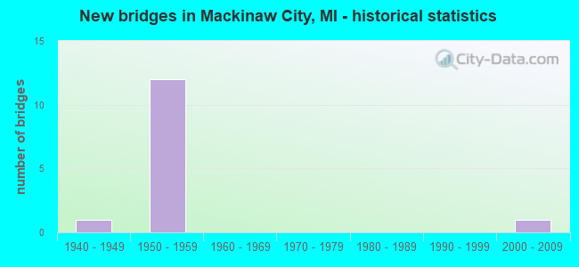
- New bridges - historical statistics
- 11940-1949
- 121950-1959
- 12000-2009

- Reconstructed bridges - Historical Statistics
- 11970-1979
- 11980-1989
- 01990-1999
- 12000-2009


- Bridge Condition - Deck
- 44.4%Good
- 44.4%Satisfactory
- 11.1%Fair

- Bridge Condition - Superstructure
- 11.1%Very good
- 33.3%Good
- 33.3%Satisfactory
- 22.2%Fair

- Bridge Condition - Substructure
- 11.1%Very good
- 66.7%Good
- 11.1%Fair
- 11.1%Poor

- Bridge Condition - Channel
- 33.3%Excellent
- 66.7%Very good
Find on map >> Show street view
Structure Number: 1519, Location: @ I-75, US-31 JCT (Lat: 45.732986, Lng: -84.728306), Route carried "on" structure: US 31, Year Built: 1959, Status: Open, Structure Length: 9.54m (31.30ft), Average Daily Traffic: 1,661 (year 2007), Truck Traffic: 9%, Average Future Daily Traffic: 2,631 (year 2018), Design Load: HS 20, Features Intersected: I-75
Minimum Vertical Clearance: 30.48m (100.00ft), Kilometerpoint: 0.378, Lanes on structure: 2, Lanes under structure: 4, Base Highway Network: Yes (Inventory Route: 55, Subroute: 10), Owner: State Highway Agency, Approaching Roadway Width: 13.7m (44.9ft), Skew: 4 degrees, Material/Design: Concrete continuous, Design/Construction: Tee Beam, Number Of Spans In Main Unit: 4, Length of Maximum Span: 29.5m (96.8ft), Curb-To-Curb Width: 10.1m (33.1ft), Out-to-Out Width: 11.4m (37.4ft)
Condition: Deck: Fair, Superstructure: Satisfactory, Substructure: Fair, Operating Rating: 60.6 metric tons, Method Used To Determine Operating Rating: Load Factor (LF) rating reported by rating factor (RF) method using MS18 loading, Inventory Rating: 36.3 metric tons, Method Used To Determine Inventory Rating: Load Factor (LF) rating reported by rating factor (RF) method using MS18 loading, Structural Evaluation: Somewhat better than minimum adequacy, Deck Geometry: Somewhat better than minimum adequacy, Underclear: Meets minimum limits, Approach Roadway Alignment: Equal to present desirable criteria, Designated Inspection Frequency: Every 24 months, Inspection Date: April 2021, Deck Structure Type: Concrete Cast-file-Place, Wearing Surface/Protective System: Wearing Surface: Epoxy Overlay
Find on map >> Show street view
Structure Number: 152, Location: @ I-75, OLD M-108 JCT (Lat: 45.762653, Lng: -84.732089), Route carried "on" structure: County highway , Year Built: 1959, Status: Open, Structure Length: 8.63m (28.31ft), Average Daily Traffic: 2,675 (year 2014), Truck Traffic: 5%, Average Future Daily Traffic: 2,950 (year 2034), Design Load: H 15, Features Intersected: I-75, Facility Carried by Structure: N MACKINAW HWY
Minimum Vertical Clearance: 30.48m (100.00ft), Kilometerpoint: 7.192, Lanes on structure: 2, Lanes under structure: 4, Owner: State Highway Agency, Approaching Roadway Width: 12.2m (40.0ft), Skew: 4 degrees, Material/Design: Concrete continuous, Design/Construction: Tee Beam, Number Of Spans In Main Unit: 4, Length of Maximum Span: 25.2m (82.7ft), Curb-To-Curb Width: 8.9m (29.2ft), Out-to-Out Width: 10.2m (33.5ft)
Condition: Deck: Satisfactory, Superstructure: Fair, Substructure: Good, Operating Rating: 57.7 metric tons, Method Used To Determine Operating Rating: Load Factor (LF) rating reported by rating factor (RF) method using MS18 loading, Inventory Rating: 34.3 metric tons, Method Used To Determine Inventory Rating: Load Factor (LF) rating reported by rating factor (RF) method using MS18 loading, Structural Evaluation: Somewhat better than minimum adequacy, Deck Geometry: Meets minimum limits, Underclear: Meets minimum limits, Approach Roadway Alignment: Equal to present minimum criteria, Designated Inspection Frequency: Every 24 months, Inspection Date: April 2020, Deck Structure Type: Concrete Cast-file-Place, Wearing Surface/Protective System: Wearing Surface: Bituminous, Membrane: Preformed Fabric
Find on map >> Show street view
Structure Number: 2452, Location: IN MACKINAW CITY (Lat: 45.780139, Lng: -84.733231), Route carried "on" structure: Interstate 75, Year Built: 1957, Year Reconstructed: 1975, Status: Open, Structure Length: 7.77m (25.49ft), Average Daily Traffic: 5,908 (year 2007), Truck Traffic: 9%, Average Future Daily Traffic: 14,992 (year 2018), Design Load: HS 20+Mod, Features Intersected: D&M RR (ABN)
Minimum Vertical Clearance: 30.48m (100.00ft), Kilometerpoint: 1.988, Lanes on structure: 4, Base Highway Network: Yes (Inventory Route: 116, Subroute: 4), Owner: State Highway Agency, Approaching Roadway Width: 22.9m (75.1ft), Skew: 39 degrees, Material/Design: Steel, Design/Construction: Stringer/Multi-beam, Number Of Spans In Main Unit: 4, Length of Maximum Span: 24.3m (79.7ft), Curb-To-Curb Width: 23.5m (77.1ft), Out-to-Out Width: 24.8m (81.4ft)
Condition: Deck: Good, Superstructure: Satisfactory, Substructure: Good, Operating Rating: 90.4 metric tons, Method Used To Determine Operating Rating: Load Factor (LF) rating reported by rating factor (RF) method using MS18 loading, Inventory Rating: 54.1 metric tons, Method Used To Determine Inventory Rating: Load Factor (LF) rating reported by rating factor (RF) method using MS18 loading, Structural Evaluation: Equal to present minimum criteria, Deck Geometry: Superior to present desirable criteria, Approach Roadway Alignment: Better than present minimum criteria, Designated Inspection Frequency: Every 24 months, Inspection Date: August 2020, Deck Structure Type: Concrete Cast-file-Place, Wearing Surface/Protective System: Wearing Surface: Latex Concrete
Find on map >> Show street view
Structure Number: 2453, Location: IN MACKINAW CITY (Lat: 45.772208, Lng: -84.734403), Route carried "on" structure: Ramp Interstate 75, Year Built: 1957, Status: Open, Structure Length: 6.22m (20.41ft), Average Daily Traffic: 1,954 (year 2007), Truck Traffic: 9%, Average Future Daily Traffic: 1,477 (year 2018), Design Load: HS 20+Mod, Features Intersected: I-75, Facility Carried by Structure: US-23 SB
Minimum Vertical Clearance: 30.48m (100.00ft), Kilometerpoint: 0.209, Lanes on structure: 2, Lanes under structure: 4, Owner: State Highway Agency, Approaching Roadway Width: 12.8m (42.0ft), Skew: 4 degrees, Material/Design: Steel, Design/Construction: Stringer/Multi-beam, Number Of Spans In Main Unit: 3, Length of Maximum Span: 34.4m (112.9ft), Curb-To-Curb Width: 10.1m (33.1ft), Out-to-Out Width: 11.4m (37.4ft)
Condition: Deck: Satisfactory, Superstructure: Fair, Substructure: Poor, Operating Rating: 63.8 metric tons, Method Used To Determine Operating Rating: Load Factor (LF) rating reported by rating factor (RF) method using MS18 loading, Inventory Rating: 38.2 metric tons, Method Used To Determine Inventory Rating: Load Factor (LF) rating reported by rating factor (RF) method using MS18 loading, Structural Evaluation: Meets minimum limits, Deck Geometry: Equal to present minimum criteria, Underclear: High priority of corrective action, Approach Roadway Alignment: Equal to present minimum criteria, Designated Inspection Frequency: Every 24 months, Other Special Inspection Frequency: Every 3 months, Inspection Date: August 2020, Other Special Inspection Date: January 2022, Deck Structure Type: Concrete Cast-file-Place, Wearing Surface/Protective System: Wearing Surface: Latex Concrete
Find on map >> Show street view
Structure Number: 2454, Location: IN MACKINAC CITY (Lat: 45.781589, Lng: -84.732997), Route carried "on" structure: Interstate 75, Year Built: 1957, Year Reconstructed: 2005, Status: Open, Structure Length: 4.00m (13.12ft), Average Daily Traffic: 5,908 (year 2007), Truck Traffic: 9%, Average Future Daily Traffic: 14,100 (year 2026), Design Load: HS 20, Features Intersected: CENTRAL ST
Minimum Vertical Clearance: 30.48m (100.00ft), Kilometerpoint: 2.150, Lanes on structure: 4, Lanes under structure: 4, Base Highway Network: Yes (Inventory Route: 116, Subroute: 4), Owner: State Highway Agency, Approaching Roadway Width: 22.8m (74.8ft), Skew: 30 degrees, Material/Design: Steel, Design/Construction: Stringer/Multi-beam, Number Of Spans In Main Unit: 3, Length of Maximum Span: 19.3m (63.3ft), Curb-To-Curb Width: 11.1m (36.4ft), Out-to-Out Width: 12.4m (40.7ft)
Condition: Deck: Satisfactory, Superstructure: Satisfactory, Substructure: Good, Operating Rating: 89.4 metric tons, Method Used To Determine Operating Rating: Load Factor (LF) rating reported by rating factor (RF) method using MS18 loading, Inventory Rating: 53.5 metric tons, Method Used To Determine Inventory Rating: Load Factor (LF) rating reported by rating factor (RF) method using MS18 loading, Structural Evaluation: Equal to present minimum criteria, Deck Geometry: High priority of replacement, Underclear: Somewhat better than minimum adequacy, Approach Roadway Alignment: Equal to present minimum criteria, Designated Inspection Frequency: Every 24 months, Inspection Date: August 2020, Bridge Improvement Cost: $735,000, Deck Structure Type: Concrete Cast-file-Place, Wearing Surface/Protective System: Wearing Surface: Latex Concrete
Find on map >> Show street view
Structure Number: 2455, Location: IN MACKINAW CITY (Lat: 45.786531, Lng: -84.732283), Route carried "on" structure: Interstate 75, Year Built: 1957, Status: Posted for load, Structure Length: 17.89m (58.69ft), Average Daily Traffic: 11,076 (year 2007), Truck Traffic: 19%, Average Future Daily Traffic: 14,257 (year 2015), Design Load: HS 20, Features Intersected: HURON AVE
Minimum Vertical Clearance: 30.48m (100.00ft), Kilometerpoint: 0.000, Lanes on structure: 4, Lanes under structure: 4, Base Highway Network: Yes (Inventory Route: 114, Subroute: 7), Toll: Toll bridge, Owner: State Toll Authority, Approaching Roadway Width: 21.3m (69.9ft), Skew: 30 degrees, Material/Design: Steel, Design/Construction: Stringer/Multi-beam, Number Of Spans In Main Unit: 14, Length of Maximum Span: 12.8m (42.0ft), Curb or Sidewalk Widths: Left: 0.7m (2.3ft), Right: 0.7m (2.3ft), Curb-To-Curb Width: 14.6m (47.9ft), Out-to-Out Width: 16.4m (53.8ft)
Condition: Deck: Good, Superstructure: Good, Substructure: Good, Operating Rating: 43.1 metric tons, Method Used To Determine Operating Rating: Load Factor (LF) rating reported by rating factor (RF) method using MS18 loading, Inventory Rating: 25.9 metric tons, Method Used To Determine Inventory Rating: Load Factor (LF) rating reported by rating factor (RF) method using MS18 loading, Structural Evaluation: Equal to present minimum criteria, Deck Geometry: High priority of replacement, Underclear: High priority of corrective action, Approach Roadway Alignment: Equal to present desirable criteria, Designated Inspection Frequency: Every 12 months, Inspection Date: August 2021, Deck Structure Type: Concrete Cast-file-Place, Wearing Surface/Protective System: Wearing Surface: Bituminous
Find on map >> Show street view
Structure Number: 2456, Location: MACKINAW CITY-ST IGNACE (Lat: 45.836839, Lng: -84.724806), Route carried "on" structure: Interstate 75, Year Built: 1957, Status: Posted for load, Structure Length: 586.67m (1924.77ft), Average Daily Traffic: 11,076 (year 2007), Truck Traffic: 7%, Average Future Daily Traffic: 17,233 (year 2018), Design Load: HS 20, Features Intersected: STRAITS OF MACKINAC
Minimum Vertical Clearance: 30.48m (100.00ft), Kilometerpoint: 0.206, Lanes on structure: 4, Base Highway Network: Yes (Inventory Route: 114, Subroute: 7), Toll: Toll bridge, Owner: State Toll Authority, Approaching Roadway Width: 24.3m (79.7ft), Skew: 20 degrees, Navigation Control: Yes ( Vertical Clearance: 41.1m (134.8ft), Horizontal Clearance: 16.4m (53.8ft)), Material/Design: Steel, Design/Construction: Suspension, Number Of Spans In Main Unit: 3, Number Of Approach Spans: 57, Length of Maximum Span: 1158.5m (3,800.9ft), Curb or Sidewalk Widths: Left: 0.7m (2.3ft), Right: 0.7m (2.3ft), Curb-To-Curb Width: 14.6m (47.9ft), Out-to-Out Width: 16.4m (53.8ft)
Condition: Deck: Satisfactory, Superstructure: Good, Substructure: Very good, Channel: Excellent, Operating Rating: 48.0 metric tons, Method Used To Determine Operating Rating: Load Factor (LF) rating reported by rating factor (RF) method using MS18 loading, Inventory Rating: 33.4 metric tons, Method Used To Determine Inventory Rating: Load Factor (LF) rating reported by rating factor (RF) method using MS18 loading, Structural Evaluation: Better than present minimum criteria, Deck Geometry: High priority of replacement, Waterway Adequacy: Superior to present desirable criteria, Approach Roadway Alignment: Superior to present desirable criteria, Designated Inspection Frequency: Every 12 months, Critical Feature Inspection Frequency: Every 24 months, Underwater Inspection Frequency: Every 60 months, Inspection Date: August 2021, Critical Feature Inspection Date: July 2020, Underwater Inspection Date: July 2017, Deck Structure Type: Concrete Cast-file-Place, Wearing Surface/Protective System: Wearing Surface: Bituminous, Membrane: Other
Find on map >> Show street view
Structure Number: 2457, Location: N OF MACKINAC BR (CAUSWAY (Lat: 45.845728, Lng: -84.723467), Route carried "on" structure: Interstate 75, Year Built: 1942, Year Reconstructed: 1985, Status: Posted for load, Structure Length: 2.74m (8.99ft), Average Daily Traffic: 11,076 (year 2007), Truck Traffic: 7%, Average Future Daily Traffic: 16,229 (year 2015), Design Load: HS 20, Features Intersected: STRAITS OF MACKINAC
Minimum Vertical Clearance: 30.48m (100.00ft), Kilometerpoint: 6.615, Lanes on structure: 4, Base Highway Network: Yes (Inventory Route: 114, Subroute: 7), Toll: Toll bridge, Owner: State Toll Authority, Approaching Roadway Width: 24.3m (79.7ft), Skew: 20 degrees, Navigation Control: Yes ( Vertical Clearance: 2.8m (9.2ft), Horizontal Clearance: 8.5m (27.9ft)), Material/Design: Steel, Design/Construction: Stringer/Multi-beam, Number Of Spans In Main Unit: 3, Length of Maximum Span: 9.1m (29.9ft), Curb or Sidewalk Widths: Left: 2.2m (7.2ft), Right: 0.3m (1.0ft), Curb-To-Curb Width: 17.1m (56.1ft), Out-to-Out Width: 18.1m (59.4ft)
Condition: Deck: Good, Superstructure: Good, Substructure: Good, Channel: Very good, Operating Rating: 55.1 metric tons, Method Used To Determine Operating Rating: Load and Resistance Factor Rating (LRFR) rating reported by rating factor(RF) method using HL-93 loadings, Inventory Rating: 42.4 metric tons, Method Used To Determine Inventory Rating: Load and Resistance Factor Rating (LRFR) rating reported by rating factor(RF) method using HL-93 loadings, Structural Evaluation: Better than present minimum criteria, Deck Geometry: High priority of corrective action, Waterway Adequacy: Equal to present desirable criteria, Approach Roadway Alignment: Equal to present desirable criteria, Designated Inspection Frequency: Every 12 months, Underwater Inspection Frequency: Every 60 months, Inspection Date: August 2021, Underwater Inspection Date: August 2017, Deck Structure Type: Concrete Cast-file-Place, Wearing Surface/Protective System: Wearing Surface: Monolithic Concrete, Deck Protection: Epoxy Coated Reinforcing
Find on map >> Show street view
Structure Number: 3482, Location: 2.1 MI S OF HARBOR BEACH (Lat: 43.818206, Lng: -82.635286), Route carried "on" structure: State highway 25, Year Built: 2003, Status: Open, Structure Length: 1.66m (5.45ft), Average Daily Traffic: 1,957 (year 2007), Truck Traffic: 6%, Average Future Daily Traffic: 2,516 (year 2018), Design Load: HS 25 or greater, Features Intersected: ROCK FALLS CREEK
Minimum Vertical Clearance: 30.48m (100.00ft), Kilometerpoint: 14.544, Lanes on structure: 2, Base Highway Network: Yes (Inventory Route: 103, Subroute: 7), Owner: State Highway Agency, Approaching Roadway Width: 13.4m (44.0ft), Material/Design: Prestressed concrete, Design/Construction: Stringer/Multi-beam, Number Of Spans In Main Unit: 1, Length of Maximum Span: 15.3m (50.2ft), Curb-To-Curb Width: 13.4m (44.0ft), Out-to-Out Width: 14.1m (46.3ft)
Condition: Deck: Good, Superstructure: Very good, Substructure: Good, Channel: Very good, Operating Rating: 61.2 metric tons, Method Used To Determine Operating Rating: Load Factor (LF) rating reported by rating factor (RF) method using MS18 loading, Inventory Rating: 36.6 metric tons, Method Used To Determine Inventory Rating: Load Factor (LF) rating reported by rating factor (RF) method using MS18 loading, Structural Evaluation: Better than present minimum criteria, Deck Geometry: Equal to present desirable criteria, Waterway Adequacy: Equal to present desirable criteria, Approach Roadway Alignment: Somewhat better than minimum adequacy, Designated Inspection Frequency: Every 24 months, Inspection Date: December 2021, Deck Structure Type: Concrete Cast-file-Place, Wearing Surface/Protective System: Wearing Surface: Monolithic Concrete, Deck Protection: Epoxy Coated Reinforcing
Find on map >> Show street view
Structure Number: 1519, Location: @ I-75, US-31 JCT (Lat: 45.732986, Lng: -84.728306), Route carried "under" structure: Interstate 75, Year Built: 1959, Structure Length: 0. m, Average Daily Traffic: 9,144 (year 2007), Truck Traffic: 14%, Features Intersected: I-75, Facility Carried by Structure: US-31 NB
Minimum Vertical Clearance: 5.13m (16.83ft), Kilometerpoint: 65.290, Lanes on structure: 2, Lanes under structure: 4, Material/Design: Concrete continuous, Design/Construction: Tee Beam, Length of Maximum Span: 29.5m (96.8ft)
Find on map >> Show street view
Structure Number: 152, Location: @ I-75, OLD M-108 JCT (Lat: 45.762653, Lng: -84.732089), Route carried "under" structure: Interstate 75, Year Built: 1959, Structure Length: 0. m, Average Daily Traffic: 8,703 (year 2012), Truck Traffic: 11%, Features Intersected: I-75, Facility Carried by Structure: N MACKINAW HWY
Minimum Vertical Clearance: 5.00m (16.40ft), Kilometerpoint: 0.000, Lanes on structure: 2, Lanes under structure: 4, Material/Design: Concrete continuous, Design/Construction: Tee Beam, Length of Maximum Span: 25.2m (82.7ft)
Find on map >> Show street view
Structure Number: 2453, Location: IN MACKINAW CITY (Lat: 45.772208, Lng: -84.734403), Route carried "under" structure: Interstate 75, Year Built: 1957, Structure Length: 0. m, Average Daily Traffic: 5,908 (year 2007), Truck Traffic: 9%, Features Intersected: I-75, Facility Carried by Structure: US-23 SB
Minimum Vertical Clearance: 4.47m (14.67ft), Kilometerpoint: 1.101, Lanes on structure: 2, Lanes under structure: 4, Material/Design: Steel, Design/Construction: Stringer/Multi-beam, Length of Maximum Span: 34.4m (112.9ft)
Find on map >> Show street view
Structure Number: 2454, Location: IN MACKINAC CITY (Lat: 45.781589, Lng: -84.732997), Route carried "under" structure: City street , Year Built: 1957, Structure Length: 0. m, Average Daily Traffic: 5,200 (year 1997), Truck Traffic: 3%, Features Intersected: CENTRAL ST, Facility Carried by Structure: I-75
Minimum Vertical Clearance: 4.75m (15.58ft), Kilometerpoint: 0.039, Lanes on structure: 4, Lanes under structure: 4, Material/Design: Steel, Design/Construction: Stringer/Multi-beam, Length of Maximum Span: 19.3m (63.3ft)
Find on map >> Show street view
Structure Number: 2455, Location: IN MACKINAW CITY (Lat: 45.786531, Lng: -84.732283), Route carried "under" structure: City street , Year Built: 1957, Structure Length: 0. m, Average Daily Traffic: 1,200 (year 1997), Features Intersected: HURON AVE, Facility Carried by Structure: I-75 S APPR
Minimum Vertical Clearance: 8.53m (27.99ft), Kilometerpoint: 0.011, Lanes on structure: 4, Lanes under structure: 4, Material/Design: Steel, Design/Construction: Stringer/Multi-beam, Length of Maximum Span: 12.8m (42.0ft)