Bridge Statistics for MacArthur, West Virginia (WV)
Condition, Traffic, Stress, Structural Evaluation, Project Costs
- National Bridge Inventory (NBI) Statistics
- 20Number of bridges
- 279ft / 84.6mTotal length
- $1,550,000Total costs
- 144,286Total average daily traffic
- 21,011Total average daily truck traffic
- National Bridge Inventory (NBI) Registered Bridges for MacArthur
- No street view available for this location
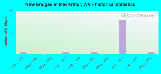
- New bridges - historical statistics
- 11910-1919
- 11940-1949
- 11960-1969
- 161980-1989
- 12000-2009

- Reconstructed bridges - Historical Statistics
- 11960-1969
- 01970-1979
- 11980-1989
- 01990-1999
- 12000-2009


- Bridge Condition - Deck
- 18.2%Very good
- 36.4%Satisfactory
- 45.5%Fair

- Bridge Condition - Superstructure
- 54.5%Satisfactory
- 36.4%Fair
- 9.1%Poor

- Bridge Condition - Substructure
- 45.5%Satisfactory
- 45.5%Fair
- 9.1%Poor

- Bridge Condition - Channel
- 40.0%Very good
- 40.0%Good
- 20.0%Fair
Find on map >> Show street view
Structure Number: 41A087, Location: 0.01 MI EAST OF CO 19/38 (Lat: 37.756911, Lng: -81.169750), Route carried "on" structure: County highway 1910, Year Built: 1910, Year Reconstructed: 2008, Status: Open, Structure Length: 1.17m (3.84ft), Average Daily Traffic: 1,400 (year 2019), Truck Traffic: 5%, Average Future Daily Traffic: 1,764 (year 2039), Design Load: HS 25 or greater, Features Intersected: WHITESTICK CREEK, Facility Carried by Structure: CO 19/10
Minimum Vertical Clearance: 30+ m (98+ ft), Kilometerpoint: 3.283, Lanes on structure: 2, Owner: State Highway Agency, Approaching Roadway Width: 6.4m (21.0ft), Skew: 2 degrees, Material/Design: Prestressed concrete, Design/Construction: Box Beam or Girders - Multiple, Number Of Spans In Main Unit: 1, Length of Maximum Span: 9.2m (30.2ft), Curb-To-Curb Width: 6.5m (21.3ft), Out-to-Out Width: 6.5m (21.3ft)
Condition: Deck: Satisfactory, Superstructure: Satisfactory, Substructure: Fair, Channel: Fair, Operating Rating: 77.1 metric tons, Method Used To Determine Operating Rating: Load Factor (LF), Inventory Rating: 46.3 metric tons, Method Used To Determine Inventory Rating: Load Factor (LF), Structural Evaluation: Somewhat better than minimum adequacy, Deck Geometry: High priority of replacement, Waterway Adequacy: Better than present minimum criteria, Approach Roadway Alignment: Somewhat better than minimum adequacy, Length Of Structure Improvement: 1.19m (3.90ft), Designated Inspection Frequency: Every 24 months, Inspection Date: May 2021, Bridge Improvement Cost: $400,000, Roadway Improvement Cost: $50,000, Total Project Cost: $450,000 ( Estimate for 2019), Deck Structure Type: Other, Wearing Surface/Protective System: Deck Protection: Epoxy Coated Reinforcing
Find on map >> Show street view
Structure Number: 41A096, Location: 0.40 MI S OF CR 19/10 (Lat: 37.751719, Lng: -81.169431), Route carried "on" structure: County highway 1938, Year Built: 1940, Year Reconstructed: 1974, Status: Posted for load, Structure Length: 1.81m (5.94ft), Average Daily Traffic: 30 (year 2019), Truck Traffic: 6%, Average Future Daily Traffic: 55 (year 2039), Features Intersected: PINEY CREEK, Facility Carried by Structure: CR 19/38
Minimum Vertical Clearance: 30+ m (98+ ft), Kilometerpoint: 0.644, Lanes on structure: 1, Owner: State Highway Agency, Approaching Roadway Width: 5.5m (18.0ft), Skew: 1 degrees, Material/Design: Steel, Design/Construction: Stringer/Multi-beam, Number Of Spans In Main Unit: 1, Number Of Approach Spans: 2, Length of Maximum Span: 6.1m (20.0ft), Curb or Sidewalk Widths: Left: 0.2m (0.7ft), Right: 0.2m (0.7ft), Curb-To-Curb Width: 4.0m (13.1ft), Out-to-Out Width: 4.4m (14.4ft)
Condition: Deck: Fair, Superstructure: Poor, Substructure: Poor, Channel: Good, Operating Rating: 9.1 metric tons, Method Used To Determine Operating Rating: Load Factor (LF), Inventory Rating: 5.4 metric tons, Method Used To Determine Inventory Rating: Load Factor (LF), Structural Evaluation: High priority of replacement, Deck Geometry: Somewhat better than minimum adequacy, Waterway Adequacy: Equal to present minimum criteria, Approach Roadway Alignment: Somewhat better than minimum adequacy, Bridge Posting: Required (Relationship of Operating Rating to Maximum Legal Load: > 39.9% below), Length Of Structure Improvement: 1.80m (5.91ft), Designated Inspection Frequency: Every 24 months, Inspection Date: September 2021, Bridge Improvement Cost: $600,000, Roadway Improvement Cost: $50,000, Total Project Cost: $650,000 ( Estimate for 2017), Deck Structure Type: Wood or Timber, Wearing Surface/Protective System: Wearing Surface: Wood or Timber
Find on map >> Show street view
Structure Number: 41A154, Location: 0.04 MI S OF CR 19/10 (Lat: 37.756731, Lng: -81.168519), Route carried "on" structure: County highway 1949, Year Built: 1960, Year Reconstructed: 1989, Status: Open, Structure Length: 2.52m (8.27ft), Average Daily Traffic: 30 (year 2019), Truck Traffic: 6%, Average Future Daily Traffic: 55 (year 2039), Design Load: HS 20, Features Intersected: PINEY CREEK, Facility Carried by Structure: CR 19/49
Minimum Vertical Clearance: 30+ m (98+ ft), Kilometerpoint: 0.064, Lanes on structure: 1, Owner: State Highway Agency, Approaching Roadway Width: 4.3m (14.1ft), Material/Design: Steel continuous, Design/Construction: Stringer/Multi-beam, Number Of Spans In Main Unit: 1, Number Of Approach Spans: 3, Length of Maximum Span: 6.1m (20.0ft), Curb-To-Curb Width: 3.4m (11.2ft), Out-to-Out Width: 3.8m (12.5ft)
Condition: Deck: Satisfactory, Superstructure: Fair, Substructure: Fair, Channel: Good, Operating Rating: 54.4 metric tons, Method Used To Determine Operating Rating: Load Factor (LF), Inventory Rating: 32.7 metric tons, Method Used To Determine Inventory Rating: Load Factor (LF), Structural Evaluation: Somewhat better than minimum adequacy, Deck Geometry: High priority of corrective action, Waterway Adequacy: Somewhat better than minimum adequacy, Approach Roadway Alignment: Better than present minimum criteria, Length Of Structure Improvement: 25.30m (83.01ft), Designated Inspection Frequency: Every 24 months, Inspection Date: May 2021, Bridge Improvement Cost: $400,000, Roadway Improvement Cost: $50,000, Total Project Cost: $450,000 ( Estimate for 2019), Deck Structure Type: Wood or Timber, Wearing Surface/Protective System: Wearing Surface: Bituminous
Find on map >> Show street view
Structure Number: 41A167, Location: 0.01 MI N OF CR 16/16 (Lat: 37.760761, Lng: -81.209519), Route carried "on" structure: County highway 338, Year Built: 1983, Status: Open, Structure Length: 10.63m (34.88ft), Average Daily Traffic: 150 (year 2019), Truck Traffic: 6%, Average Future Daily Traffic: 276 (year 2039), Design Load: HS 20, Features Intersected: WV 16, Facility Carried by Structure: CR 3/38
Minimum Vertical Clearance: 30+ m (98+ ft), Kilometerpoint: 0.016, Lanes on structure: 2, Lanes under structure: 6, Owner: State Highway Agency, Approaching Roadway Width: 12.2m (40.0ft), Material/Design: Steel continuous, Design/Construction: Stringer/Multi-beam, Number Of Spans In Main Unit: 1, Number Of Approach Spans: 3, Length of Maximum Span: 33.4m (109.6ft), Curb or Sidewalk Widths: Left: 1.2m (3.9ft), Right: 0.0m, Curb-To-Curb Width: 10.6m (34.8ft), Out-to-Out Width: 13.2m (43.3ft)
Condition: Deck: Fair, Superstructure: Fair, Substructure: Fair, Operating Rating: 66.2 metric tons, Method Used To Determine Operating Rating: Load Factor (LF), Inventory Rating: 39.9 metric tons, Method Used To Determine Inventory Rating: Load Factor (LF), Structural Evaluation: Somewhat better than minimum adequacy, Deck Geometry: Better than present minimum criteria, Underclear: Equal to present minimum criteria, Approach Roadway Alignment: Equal to present minimum criteria, Designated Inspection Frequency: Every 24 months, Inspection Date: June 2021, Deck Structure Type: Concrete Cast-file-Place, Wearing Surface/Protective System: Wearing Surface: Monolithic Concrete, Deck Protection: Epoxy Coated Reinforcing
Find on map >> Show street view
Structure Number: 41A184, Location: 0.14 MI S OF CR 20 (Lat: 37.731800, Lng: -81.192169), Route carried "on" structure: County highway 1941, Year Built: 1984, Status: Open, Structure Length: 11.96m (39.24ft), Average Daily Traffic: 20 (year 2018), Truck Traffic: 5%, Average Future Daily Traffic: 25 (year 2038), Design Load: HS 20, Features Intersected: I 64 Ramps A B C D, Facility Carried by Structure: CR 19/41
Minimum Vertical Clearance: 30+ m (98+ ft), Kilometerpoint: 11.040, Lanes on structure: 2, Lanes under structure: 9, Owner: State Highway Agency, Approaching Roadway Width: 6.1m (20.0ft), Material/Design: Steel continuous, Design/Construction: Stringer/Multi-beam, Number Of Spans In Main Unit: 1, Number Of Approach Spans: 2, Length of Maximum Span: 51.5m (169.0ft), Curb-To-Curb Width: 7.3m (24.0ft), Out-to-Out Width: 8.4m (27.6ft)
Condition: Deck: Fair, Superstructure: Fair, Substructure: Fair, Operating Rating: 63.5 metric tons, Method Used To Determine Operating Rating: Load Factor (LF), Inventory Rating: 38.1 metric tons, Method Used To Determine Inventory Rating: Load Factor (LF), Structural Evaluation: Somewhat better than minimum adequacy, Deck Geometry: Equal to present minimum criteria, Underclear: Somewhat better than minimum adequacy, Approach Roadway Alignment: Equal to present minimum criteria, Designated Inspection Frequency: Every 24 months, Inspection Date: March 2021, Deck Structure Type: Concrete Cast-file-Place, Wearing Surface/Protective System: Wearing Surface: Monolithic Concrete, Deck Protection: Epoxy Coated Reinforcing
Find on map >> Show street view
Structure Number: 41A189, Location: 1.12 MI. E. FORM I-77 (Lat: 37.731031, Lng: -81.193381), Route carried "on" structure: Interstate 6400, Year Built: 1985, Status: Open, Structure Length: 11.29m (37.04ft), Average Daily Traffic: 1,220 (year 2018), Truck Traffic: 17%, Average Future Daily Traffic: 37,632 (year 2038), Design Load: HS 20+Mod, Features Intersected: I-77 SB ramp, Facility Carried by Structure: I-64 EB
Minimum Vertical Clearance: 30+ m (98+ ft), Kilometerpoint: 193.540, Lanes on structure: 3, Lanes under structure: 2, Base Highway Network: Yes, Toll: On Interstate toll segment, Owner: State Toll Authority, Approaching Roadway Width: 12.8m (42.0ft), Skew: 5 degrees, Material/Design: Steel continuous, Design/Construction: Stringer/Multi-beam, Number Of Spans In Main Unit: 1, Number Of Approach Spans: 2, Length of Maximum Span: 50.6m (166.0ft), Curb-To-Curb Width: 14.3m (46.9ft), Out-to-Out Width: 15.3m (50.2ft)
Condition: Deck: Fair, Superstructure: Satisfactory, Substructure: Satisfactory, Operating Rating: 59.0 metric tons, Method Used To Determine Operating Rating: Load Factor (LF), Inventory Rating: 35.4 metric tons, Method Used To Determine Inventory Rating: Load Factor (LF), Structural Evaluation: Equal to present minimum criteria, Deck Geometry: Meets minimum limits, Underclear: Equal to present desirable criteria, Approach Roadway Alignment: Equal to present desirable criteria, Designated Inspection Frequency: Every 24 months, Inspection Date: June 2020, Deck Structure Type: Concrete Cast-file-Place, Wearing Surface/Protective System: Wearing Surface: Monolithic Concrete, Deck Protection: Epoxy Coated Reinforcing
Find on map >> Show street view
Structure Number: 41A221, Location: 1.05 MI N OF I-64 I/C (Lat: 37.743289, Lng: -81.207881), Route carried "on" structure: Interstate 7700, Year Built: 1985, Status: Open, Structure Length: 11.80m (38.71ft), Average Daily Traffic: 20,658 (year 2018), Truck Traffic: 17%, Average Future Daily Traffic: 41,317 (year 2038), Design Load: HS 20+Mod, Features Intersected: PINEY CREEK and CSX RR, Facility Carried by Structure: I-77 NB
Minimum Vertical Clearance: 30+ m (98+ ft), Kilometerpoint: 65.710, Lanes on structure: 2, Base Highway Network: Yes, Toll: On Interstate toll segment, Owner: State Toll Authority, Approaching Roadway Width: 11.3m (37.1ft), Skew: 1 degrees, Material/Design: Steel continuous, Design/Construction: Stringer/Multi-beam, Number Of Spans In Main Unit: 1, Number Of Approach Spans: 2, Length of Maximum Span: 52.1m (170.9ft), Curb-To-Curb Width: 12.4m (40.7ft), Out-to-Out Width: 13.5m (44.3ft)
Condition: Deck: Very good, Superstructure: Satisfactory, Substructure: Satisfactory, Channel: Very good, Operating Rating: 71.7 metric tons, Method Used To Determine Operating Rating: Load Factor (LF), Inventory Rating: 42.6 metric tons, Method Used To Determine Inventory Rating: Load Factor (LF), Structural Evaluation: Equal to present minimum criteria, Deck Geometry: Better than present minimum criteria, Underclear: Somewhat better than minimum adequacy, Waterway Adequacy: Superior to present desirable criteria, Approach Roadway Alignment: Equal to present desirable criteria, Designated Inspection Frequency: Every 24 months, Other Special Inspection Frequency: Every 12 months, Inspection Date: October 2021, Other Special Inspection Date: October 2021, Deck Structure Type: Concrete Cast-file-Place, Wearing Surface/Protective System: Wearing Surface: Monolithic Concrete, Deck Protection: Epoxy Coated Reinforcing
Find on map >> Show street view
Structure Number: 41A222, Location: AT I-64, I-77 I/C (Lat: 37.728931, Lng: -81.192989), Route carried "on" structure: Interstate 7700, Year Built: 1985, Status: Open, Structure Length: 11.31m (37.11ft), Average Daily Traffic: 10,303 (year 2020), Truck Traffic: 17%, Average Future Daily Traffic: 19,320 (year 2040), Design Load: HS 20+Mod, Features Intersected: I-64W TO I-77S CONNECTOR, Facility Carried by Structure: I-77 NB
Minimum Vertical Clearance: 30+ m (98+ ft), Kilometerpoint: 63.456, Lanes on structure: 2, Lanes under structure: 2, Base Highway Network: Yes, Toll: On Interstate toll segment, Owner: State Toll Authority, Approaching Roadway Width: 11.3m (37.1ft), Skew: 5 degrees, Material/Design: Steel continuous, Design/Construction: Stringer/Multi-beam, Number Of Spans In Main Unit: 1, Number Of Approach Spans: 2, Length of Maximum Span: 50.6m (166.0ft), Curb-To-Curb Width: 12.4m (40.7ft), Out-to-Out Width: 13.5m (44.3ft)
Condition: Deck: Satisfactory, Superstructure: Satisfactory, Substructure: Satisfactory, Operating Rating: 57.1 metric tons, Method Used To Determine Operating Rating: Load Factor (LF), Inventory Rating: 34.5 metric tons, Method Used To Determine Inventory Rating: Load Factor (LF), Structural Evaluation: Equal to present minimum criteria, Deck Geometry: Better than present minimum criteria, Underclear: Superior to present desirable criteria, Approach Roadway Alignment: Equal to present desirable criteria, Designated Inspection Frequency: Every 24 months, Inspection Date: December 2021, Deck Structure Type: Concrete Cast-file-Place, Wearing Surface/Protective System: Wearing Surface: Monolithic Concrete, Deck Protection: Epoxy Coated Reinforcing
Find on map >> Show street view
Structure Number: 41A223, Location: AT I-64, I-77 I/C (Lat: 37.730061, Lng: -81.195961), Route carried "on" structure: Interstate 7700, Year Built: 1985, Status: Open, Structure Length: 9.59m (31.46ft), Average Daily Traffic: 9,200 (year 2020), Truck Traffic: 17%, Average Future Daily Traffic: 19,320 (year 2040), Design Load: HS 20+Mod, Features Intersected: I-77S TO I-64E CONNECTOR, Facility Carried by Structure: I-77 NB
Minimum Vertical Clearance: 30+ m (98+ ft), Kilometerpoint: 63.746, Lanes on structure: 2, Lanes under structure: 3, Base Highway Network: Yes, Toll: On Interstate toll segment, Owner: State Toll Authority, Approaching Roadway Width: 11.3m (37.1ft), Skew: 6 degrees, Material/Design: Steel continuous, Design/Construction: Stringer/Multi-beam, Number Of Spans In Main Unit: 1, Number Of Approach Spans: 2, Length of Maximum Span: 38.4m (126.0ft), Curb-To-Curb Width: 12.4m (40.7ft), Out-to-Out Width: 13.5m (44.3ft)
Condition: Deck: Fair, Superstructure: Fair, Substructure: Fair, Operating Rating: 56.2 metric tons, Method Used To Determine Operating Rating: Load Factor (LF), Inventory Rating: 33.6 metric tons, Method Used To Determine Inventory Rating: Load Factor (LF), Structural Evaluation: Somewhat better than minimum adequacy, Deck Geometry: Better than present minimum criteria, Underclear: Somewhat better than minimum adequacy, Approach Roadway Alignment: Equal to present desirable criteria, Designated Inspection Frequency: Every 24 months, Inspection Date: December 2021, Deck Structure Type: Concrete Cast-file-Place, Wearing Surface/Protective System: Wearing Surface: Monolithic Concrete, Deck Protection: Epoxy Coated Reinforcing
Find on map >> Show street view
Structure Number: 41A225, Location: 2.28 MI N OF I-64 I/C (Lat: 37.758400, Lng: -81.212911), Route carried "on" structure: Interstate 7700, Year Built: 1985, Status: Open, Structure Length: 10.94m (35.89ft), Average Daily Traffic: 35,075 (year 2019), Truck Traffic: 17%, Average Future Daily Traffic: 56,120 (year 2039), Design Load: HS 20+Mod, Features Intersected: WV Rt 16 & Pemberton Rd, Facility Carried by Structure: I-77 SB
Minimum Vertical Clearance: 30+ m (98+ ft), Kilometerpoint: 67.592, Lanes on structure: 3, Lanes under structure: 7, Base Highway Network: Yes, Toll: On Interstate toll segment, Owner: State Toll Authority, Approaching Roadway Width: 11.3m (37.1ft), Skew: 2 degrees, Material/Design: Steel continuous, Design/Construction: Stringer/Multi-beam, Number Of Spans In Main Unit: 1, Number Of Approach Spans: 4, Length of Maximum Span: 27.3m (89.6ft), Curb-To-Curb Width: 17.3m (56.8ft), Out-to-Out Width: 18.3m (60.0ft)
Condition: Deck: Very good, Superstructure: Satisfactory, Substructure: Satisfactory, Operating Rating: 61.7 metric tons, Method Used To Determine Operating Rating: Load Factor (LF), Inventory Rating: 36.3 metric tons, Method Used To Determine Inventory Rating: Load Factor (LF), Structural Evaluation: Equal to present minimum criteria, Deck Geometry: Better than present minimum criteria, Underclear: Meets minimum limits, Approach Roadway Alignment: Equal to present desirable criteria, Designated Inspection Frequency: Every 24 months, Inspection Date: November 2021, Deck Structure Type: Concrete Cast-file-Place, Wearing Surface/Protective System: Wearing Surface: Monolithic Concrete, Deck Protection: Epoxy Coated Reinforcing
Find on map >> Show street view
Structure Number: 41A289, Location: 0.23 MILE E OF CO 20/1 (Lat: 37.742981, Lng: -81.190469), Route carried "on" structure: County highway 2000, Year Built: 2002, Status: Open, Structure Length: 1.58m (5.18ft), Average Daily Traffic: 100 (year 2018), Truck Traffic: 5%, Average Future Daily Traffic: 126 (year 2038), Design Load: HS 25 or greater, Features Intersected: PINEY CREEK, Facility Carried by Structure: COUNTY ROUTE 20
Minimum Vertical Clearance: 30+ m (98+ ft), Kilometerpoint: 3.203, Lanes on structure: 2, Owner: State Highway Agency, Approaching Roadway Width: 4.9m (16.1ft), Material/Design: Prestressed concrete, Design/Construction: Box Beam or Girders - Multiple, Number Of Spans In Main Unit: 1, Length of Maximum Span: 14.6m (47.9ft), Curb-To-Curb Width: 6.5m (21.3ft), Out-to-Out Width: 6.5m (21.3ft)
Condition: Deck: Satisfactory, Superstructure: Satisfactory, Substructure: Satisfactory, Channel: Very good, Operating Rating: 77.1 metric tons, Method Used To Determine Operating Rating: Load Factor (LF), Inventory Rating: 46.3 metric tons, Method Used To Determine Inventory Rating: Load Factor (LF), Structural Evaluation: Equal to present minimum criteria, Deck Geometry: Somewhat better than minimum adequacy, Waterway Adequacy: Equal to present minimum criteria, Approach Roadway Alignment: Meets minimum limits, Designated Inspection Frequency: Every 48 months, Inspection Date: October 2019, Deck Structure Type: Other, Wearing Surface/Protective System: Deck Protection: Epoxy Coated Reinforcing
Find on map >> Show street view
Structure Number: 41A167, Location: 0.01 MI N OF CR 16/16 (Lat: 37.760761, Lng: -81.209519), Route carried "under" structure: State highway 1600, Year Built: 1983, Structure Length: 0. m, Average Daily Traffic: 20,500 (year 0009), Truck Traffic: 6%, Features Intersected: WV 16, Facility Carried by Structure: CR 3/38
Minimum Vertical Clearance: 14.71m (48.26ft), Kilometerpoint: 25.943, Lanes on structure: 2, Lanes under structure: 6, Length of Maximum Span: 33.4m (109.6ft)
Find on map >> Show street view
Structure Number: 41A184, Location: 0.14 MI S OF CR 20 (Lat: 37.731961, Lng: -81.192881), Route carried "under" structure: Ramp Interstate 6400, Year Built: 1984, Structure Length: 0. m, Average Daily Traffic: 7,800 (year 0009), Truck Traffic: 17%, Features Intersected: I 64 Ramps A B C D, Facility Carried by Structure: CR 19/41
Minimum Vertical Clearance: 10.36m (33.99ft), Kilometerpoint: 193.250, Lanes on structure: 2, Lanes under structure: 2, Length of Maximum Span: 51.5m (169.0ft)
Find on map >> Show street view
Structure Number: 41A184, Location: 0.14 MI S OF CR 20 (Lat: 37.731961, Lng: -81.192881), Route carried "under" structure: Ramp Interstate 6400, Year Built: 1984, Structure Length: 0. m, Average Daily Traffic: 800 (year 0009), Truck Traffic: 17%, Features Intersected: I 64 Ramps A B C D, Facility Carried by Structure: CR 19/41
Minimum Vertical Clearance: 5.74m (18.83ft), Kilometerpoint: 193.234, Lanes on structure: 2, Lanes under structure: 2, Length of Maximum Span: 51.5m (169.0ft)
Find on map >> Show street view
Structure Number: 41A184, Location: 0.14 MI S OF CR 20 (Lat: 37.731961, Lng: -81.192881), Route carried "under" structure: Ramp Interstate 6400, Year Built: 1984, Structure Length: 0. m, Average Daily Traffic: 7,700 (year 0009), Truck Traffic: 17%, Features Intersected: I 64 Ramps A B C D, Facility Carried by Structure: CR 19/41
Minimum Vertical Clearance: 5.08m (16.67ft), Kilometerpoint: 193.234, Lanes on structure: 2, Lanes under structure: 3, Length of Maximum Span: 51.5m (169.0ft)
Find on map >> Show street view
Structure Number: 41A184, Location: 0.14 MI S OF CR 20 (Lat: 37.731961, Lng: -81.192881), Route carried "under" structure: Ramp Interstate 6400, Year Built: 1984, Structure Length: 0. m, Average Daily Traffic: 900 (year 0009), Truck Traffic: 17%, Features Intersected: I 64 Ramps A B C D, Facility Carried by Structure: CR 19/41
Minimum Vertical Clearance: 11.58m (37.99ft), Kilometerpoint: 193.250, Lanes on structure: 2, Lanes under structure: 2, Length of Maximum Span: 51.5m (169.0ft)
Find on map >> Show street view
Structure Number: 41A189, Location: 1.12 MI. E. FORM I-77 (Lat: 37.731031, Lng: -81.193381), Route carried "under" structure: Ramp Interstate 6400, Year Built: 1985, Structure Length: 0. m, Average Daily Traffic: 3,500 (year 0006), Truck Traffic: 25%, Features Intersected: I-77 SB ramp, Facility Carried by Structure: I-64 EB
Minimum Vertical Clearance: 5.41m (17.75ft), Kilometerpoint: 193.540, Lanes on structure: 3, Lanes under structure: 2, Toll: On Interstate toll segment, Length of Maximum Span: 50.6m (166.0ft)
Find on map >> Show street view
Structure Number: 41A222, Location: AT I-64, I-77 I/C (Lat: 37.730061, Lng: -81.195961), Route carried "under" structure: Ramp Interstate 6400, Year Built: 1985, Structure Length: 0. m, Average Daily Traffic: 3,700 (year 0006), Truck Traffic: 25%, Features Intersected: I-64W TO I-77S CONNECTOR, Facility Carried by Structure: I-77 NB
Minimum Vertical Clearance: 5.54m (18.18ft), Kilometerpoint: 192.848, Lanes on structure: 2, Lanes under structure: 2, Toll: On Interstate toll segment, Length of Maximum Span: 50.6m (166.0ft)
Find on map >> Show street view
Structure Number: 41A223, Location: AT I-64, I-77 I/C (Lat: 37.728931, Lng: -81.192989), Route carried "under" structure: Ramp Interstate 6400, Year Built: 1985, Structure Length: 0. m, Average Daily Traffic: 3,700 (year 0006), Truck Traffic: 25%, Features Intersected: I-77S TO I-64E CONNECTOR, Facility Carried by Structure: I-77 NB
Minimum Vertical Clearance: 5.05m (16.57ft), Kilometerpoint: 193.234, Lanes on structure: 2, Lanes under structure: 3, Toll: On Interstate toll segment, Length of Maximum Span: 38.4m (126.0ft)
Find on map >> Show street view
Structure Number: 41A225, Location: 2.28 MI N OF I-64 I/C (Lat: 37.758400, Lng: -81.212911), Route carried "under" structure: State highway 1600, Year Built: 1985, Structure Length: 0. m, Average Daily Traffic: 17,500 (year 0006), Truck Traffic: 6%, Features Intersected: WV Rt 16 & Pemberton Rd, Facility Carried by Structure: I-77 SB
Minimum Vertical Clearance: 7.06m (23.16ft), Kilometerpoint: 25.074, Lanes on structure: 3, Lanes under structure: 7, Toll: On Interstate toll segment, Length of Maximum Span: 27.3m (89.6ft)