Bridge Statistics for Mabscott, West Virginia (WV)
Condition, Traffic, Stress, Structural Evaluation, Project Costs
- National Bridge Inventory (NBI) Statistics
- 10Number of bridges
- 105ft / 32.3mTotal length
- $13,500,000Total costs
- 127,525Total average daily traffic
- 17,470Total average daily truck traffic
- National Bridge Inventory (NBI) Registered Bridges for Mabscott
- No street view available for this location
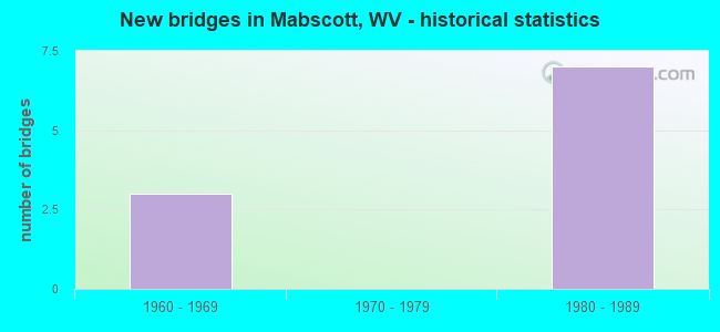
- New bridges - historical statistics
- 31960-1969
- 71980-1989


- Bridge Condition - Deck
- 20.0%Very good
- 60.0%Fair
- 20.0%Poor

- Bridge Condition - Superstructure
- 80.0%Fair
- 20.0%Poor

- Bridge Condition - Substructure
- 20.0%Satisfactory
- 40.0%Fair
- 40.0%Poor

- Bridge Condition - Channel
- 50.0%Good
- 50.0%Satisfactory
Find on map >> Show street view
Structure Number: 41A163, Location: 0.23 MI N OF CR 16/16 (Lat: 37.765650, Lng: -81.203889), Route carried "on" structure: State highway 1600, Year Built: 1960, Status: Posted for load, Structure Length: 12.06m (39.57ft), Average Daily Traffic: 16,200 (year 2019), Truck Traffic: 7%, Average Future Daily Traffic: 19,440 (year 2039), Design Load: H 20, Features Intersected: WV 16 Ramps, CSX, city, Facility Carried by Structure: WV 16
Minimum Vertical Clearance: 30+ m (98+ ft), Kilometerpoint: 26.297, Lanes on structure: 4, Lanes under structure: 3, Owner: State Highway Agency, Approaching Roadway Width: 7.9m (25.9ft), Skew: 22 degrees, Material/Design: Steel continuous, Design/Construction: Stringer/Multi-beam, Number Of Spans In Main Unit: 1, Number Of Approach Spans: 6, Length of Maximum Span: 23.8m (78.1ft), Curb-To-Curb Width: 17.2m (56.4ft), Out-to-Out Width: 19.3m (63.3ft)
Condition: Deck: Poor, Superstructure: Poor, Substructure: Poor, Channel: Satisfactory, Operating Rating: 38.1 metric tons, Method Used To Determine Operating Rating: Load Factor (LF), Inventory Rating: 22.7 metric tons, Method Used To Determine Inventory Rating: Load Factor (LF), Structural Evaluation: Meets minimum limits, Deck Geometry: Somewhat better than minimum adequacy, Underclear: High priority of replacement, Waterway Adequacy: Superior to present desirable criteria, Approach Roadway Alignment: Better than present minimum criteria, Length Of Structure Improvement: 12.06m (39.57ft), Designated Inspection Frequency: Every 24 months, Inspection Date: July 2021, Bridge Improvement Cost: $10,000,000, Roadway Improvement Cost: $1,000,000, Total Project Cost: $11,000,000 ( Estimate for 2019), Deck Structure Type: Concrete Cast-file-Place, Wearing Surface/Protective System: Wearing Surface: Bituminous
Find on map >> Show street view
Structure Number: 41A168, Location: 0.05 MI N OF CR 16/16 (Lat: 37.759931, Lng: -81.210961), Route carried "on" structure: State highway 1600, Year Built: 1983, Status: Open, Structure Length: 6.21m (20.37ft), Average Daily Traffic: 16,200 (year 2019), Truck Traffic: 6%, Average Future Daily Traffic: 20,412 (year 2039), Design Load: HS 20, Features Intersected: Ramp Conn. I77 and WV 16, Facility Carried by Structure: WV RT 16
Minimum Vertical Clearance: 30+ m (98+ ft), Kilometerpoint: 25.267, Lanes on structure: 5, Lanes under structure: 4, Base Highway Network: Yes, Owner: State Highway Agency, Approaching Roadway Width: 21.3m (69.9ft), Skew: 32 degrees, Material/Design: Steel continuous, Design/Construction: Stringer/Multi-beam, Number Of Spans In Main Unit: 1, Number Of Approach Spans: 1, Length of Maximum Span: 31.4m (103.0ft), Curb-To-Curb Width: 30.0m (98.4ft), Out-to-Out Width: 31.8m (104.3ft)
Condition: Deck: Fair, Superstructure: Fair, Substructure: Poor, Operating Rating: 68.9 metric tons, Method Used To Determine Operating Rating: Load Factor (LF), Inventory Rating: 40.8 metric tons, Method Used To Determine Inventory Rating: Load Factor (LF), Structural Evaluation: Meets minimum limits, Deck Geometry: Superior to present desirable criteria, Underclear: Somewhat better than minimum adequacy, Approach Roadway Alignment: Equal to present desirable criteria, Length Of Structure Improvement: 6.21m (20.37ft), Designated Inspection Frequency: Every 24 months, Inspection Date: June 2021, Bridge Improvement Cost: $2,000,000, Roadway Improvement Cost: $100,000, Total Project Cost: $2,100,000 ( Estimate for 2019), Deck Structure Type: Concrete Cast-file-Place, Wearing Surface/Protective System: Wearing Surface: Monolithic Concrete, Deck Protection: Epoxy Coated Reinforcing
Find on map >> Show street view
Structure Number: 41A171, Location: 0.05 Mi. W Of Co. 16/10 (Lat: 37.776911, Lng: -81.216219), Route carried "on" structure: County highway 321, Year Built: 1987, Status: Open, Structure Length: 0.84m (2.76ft), Average Daily Traffic: 1,400 (year 2018), Truck Traffic: 5%, Average Future Daily Traffic: 1,764 (year 2038), Design Load: HS 20, Features Intersected: WHITESTICK CREEK, Facility Carried by Structure: COUNTY RT 3/21
Minimum Vertical Clearance: 30+ m (98+ ft), Kilometerpoint: 2.865, Lanes on structure: 2, Owner: State Highway Agency, Approaching Roadway Width: 6.1m (20.0ft), Material/Design: Prestressed concrete, Design/Construction: Box Beam or Girders - Multiple, Number Of Spans In Main Unit: 1, Length of Maximum Span: 7.3m (24.0ft), Curb-To-Curb Width: 7.0m (23.0ft), Out-to-Out Width: 7.4m (24.3ft)
Condition: Deck: Fair, Superstructure: Fair, Substructure: Fair, Channel: Good, Operating Rating: 86.2 metric tons, Method Used To Determine Operating Rating: Load Factor (LF), Inventory Rating: 51.7 metric tons, Method Used To Determine Inventory Rating: Load Factor (LF), Structural Evaluation: Somewhat better than minimum adequacy, Deck Geometry: High priority of corrective action, Waterway Adequacy: Equal to present minimum criteria, Approach Roadway Alignment: Equal to present desirable criteria, Length Of Structure Improvement: 0.85m (2.79ft), Designated Inspection Frequency: Every 24 months, Inspection Date: January 2020, Bridge Improvement Cost: $350,000, Roadway Improvement Cost: $50,000, Total Project Cost: $400,000 ( Estimate for 2020), Deck Structure Type: Other, Wearing Surface/Protective System: Wearing Surface: Bituminous
Find on map >> Show street view
Structure Number: 41A178, Location: 0.36 MI. E. OF CR. 3/18 (Lat: 37.772700, Lng: -81.220339), Route carried "on" structure: County highway 321, Year Built: 1983, Status: Open, Structure Length: 7.59m (24.90ft), Average Daily Traffic: 1,400 (year 2018), Truck Traffic: 5%, Average Future Daily Traffic: 1,764 (year 2038), Design Load: HS 20+Mod, Features Intersected: CR. 3/21, Facility Carried by Structure: CR 3/2
Minimum Vertical Clearance: 30+ m (98+ ft), Kilometerpoint: 2.092, Lanes on structure: 2, Lanes under structure: 4, Toll: On toll road, Owner: State Highway Agency, Approaching Roadway Width: 6.1m (20.0ft), Material/Design: Steel continuous, Design/Construction: Stringer/Multi-beam, Number Of Spans In Main Unit: 2, Length of Maximum Span: 38.4m (126.0ft), Curb or Sidewalk Widths: Left: 0.0m, Right: 1.3m (4.3ft), Curb-To-Curb Width: 11.8m (38.7ft), Out-to-Out Width: 14.4m (47.2ft)
Condition: Deck: Fair, Superstructure: Fair, Substructure: Fair, Operating Rating: 62.6 metric tons, Method Used To Determine Operating Rating: Load Factor (LF), Inventory Rating: 37.2 metric tons, Method Used To Determine Inventory Rating: Load Factor (LF), Structural Evaluation: Somewhat better than minimum adequacy, Deck Geometry: Equal to present minimum criteria, Underclear: Meets minimum limits, Approach Roadway Alignment: Equal to present minimum criteria, Designated Inspection Frequency: Every 24 months, Inspection Date: September 2020, Deck Structure Type: Concrete Cast-file-Place, Wearing Surface/Protective System: Wearing Surface: Monolithic Concrete, Deck Protection: Epoxy Coated Reinforcing
Find on map >> Show street view
Structure Number: 41A227, Location: 0.27 MI N OF RT 16 I/C (Lat: 37.762281, Lng: -81.214669), Route carried "on" structure: Interstate 7700, Year Built: 1985, Status: Open, Structure Length: 5.55m (18.21ft), Average Daily Traffic: 35,075 (year 2019), Truck Traffic: 17%, Average Future Daily Traffic: 56,120 (year 2039), Design Load: HS 20+Mod, Features Intersected: ROUTE 16 CONNECTOR, Facility Carried by Structure: I-77 SB
Minimum Vertical Clearance: 30+ m (98+ ft), Kilometerpoint: 68.075, Lanes on structure: 3, Lanes under structure: 3, Base Highway Network: Yes, Toll: On Interstate toll segment, Owner: State Toll Authority, Approaching Roadway Width: 12.8m (42.0ft), Material/Design: Steel continuous, Design/Construction: Stringer/Multi-beam, Number Of Spans In Main Unit: 1, Number Of Approach Spans: 1, Length of Maximum Span: 27.7m (90.9ft), Curb-To-Curb Width: 15.5m (50.9ft), Out-to-Out Width: 16.6m (54.5ft)
Condition: Deck: Very good, Superstructure: Fair, Substructure: Satisfactory, Operating Rating: 55.3 metric tons, Method Used To Determine Operating Rating: Load Factor (LF), Inventory Rating: 34.5 metric tons, Method Used To Determine Inventory Rating: Load Factor (LF), Structural Evaluation: Somewhat better than minimum adequacy, Deck Geometry: Somewhat better than minimum adequacy, Underclear: Somewhat better than minimum adequacy, Approach Roadway Alignment: Equal to present desirable criteria, Designated Inspection Frequency: Every 24 months, Inspection Date: November 2021, Deck Structure Type: Concrete Cast-file-Place, Wearing Surface/Protective System: Wearing Surface: Monolithic Concrete, Deck Protection: Epoxy Coated Reinforcing
Find on map >> Show street view
Structure Number: 41A163, Location: 0.23 MI N OF CR 16/16 (Lat: 37.765611, Lng: -81.203889), Route carried "under" structure: Ramp State highway 1616, Year Built: 1960, Structure Length: 0. m, Average Daily Traffic: 50 (year 0009), Features Intersected: WV 16 Ramps, CSX, city, Facility Carried by Structure: WV 16
Minimum Vertical Clearance: 4.62m (15.16ft), Kilometerpoint: 1.754, Lanes on structure: 4, Lanes under structure: 2, Length of Maximum Span: 23.8m (78.1ft)
Find on map >> Show street view
Structure Number: 41A163, Location: 0.23 MI N OF CR 16/16 (Lat: 37.765661, Lng: -81.202519), Route carried "under" structure: City street , Year Built: 1960, Structure Length: 0. m, Average Daily Traffic: 1,200 (year 0009), Truck Traffic: 6%, Features Intersected: WV 16 Ramps, CSX, city, Facility Carried by Structure: WV 16
Minimum Vertical Clearance: 4.70m (15.42ft), Kilometerpoint: 26.297, Lanes on structure: 4, Lanes under structure: 2, Length of Maximum Span: 23.8m (78.1ft)
Find on map >> Show street view
Structure Number: 41A168, Location: 0.05 MI N OF CR 16/16 (Lat: 37.760289, Lng: -81.210761), Route carried "under" structure: Ramp Interstate 7700, Year Built: 1983, Structure Length: 0. m, Average Daily Traffic: 6,500 (year 0009), Truck Traffic: 17%, Features Intersected: Ramp Conn. I77 and WV 16, Facility Carried by Structure: WV RT 16
Minimum Vertical Clearance: 5.11m (16.77ft), Kilometerpoint: 67.592, Lanes on structure: 5, Lanes under structure: 4, Length of Maximum Span: 31.4m (103.0ft)
Find on map >> Show street view
Structure Number: 41A178, Location: 0.36 MI. E. OF CR. 3/18 (Lat: 37.772750, Lng: -81.220419), Route carried "under" structure: Interstate 7700, Year Built: 1983, Structure Length: 0. m, Average Daily Traffic: 46,500 (year 0009), Truck Traffic: 17%, Features Intersected: CR. 3/21, Facility Carried by Structure: CR 3/2
Minimum Vertical Clearance: 4.85m (15.91ft), Kilometerpoint: 69.379, Lanes on structure: 2, Lanes under structure: 4, Toll: On toll road, Length of Maximum Span: 38.4m (126.0ft)
Find on map >> Show street view
Structure Number: 41A227, Location: 0.27 MI N OF RT 16 I/C (Lat: 37.762281, Lng: -81.214669), Route carried "under" structure: Ramp State highway 1600, Year Built: 1985, Structure Length: 0. m, Average Daily Traffic: 3,000 (year 0006), Truck Traffic: 6%, Features Intersected: ROUTE 16 CONNECTOR, Facility Carried by Structure: I-77 SB
Minimum Vertical Clearance: 5.03m (16.50ft), Kilometerpoint: 25.154, Lanes on structure: 3, Lanes under structure: 3, Toll: On Interstate toll segment, Length of Maximum Span: 27.7m (90.9ft)