Bridge Statistics for Lyons, New York (NY)
Condition, Traffic, Stress, Structural Evaluation, Project Costs
- National Bridge Inventory (NBI) Statistics
- 12Number of bridges
- 187ft / 57.1mTotal length
- $29,936,000Total costs
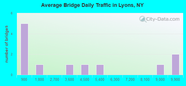
- 42,326Total average daily traffic
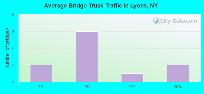
- 3,691Total average daily truck traffic
- National Bridge Inventory (NBI) Registered Bridges for Lyons
- No street view available for this location
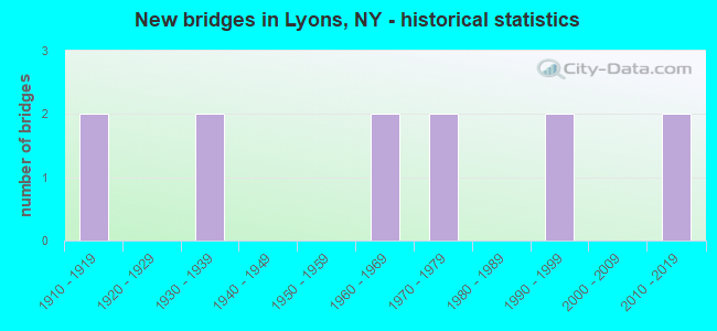
- New bridges - historical statistics
- 21910-1919
- 21930-1939
- 21960-1969
- 21970-1979
- 21990-1999
- 22010-2019
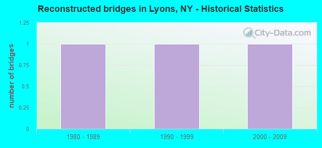
- Reconstructed bridges - Historical Statistics
- 11980-1989
- 11990-1999
- 12000-2009
- Bridge Condition - Deck
- 30.0%Very good
- 20.0%Good
- 10.0%Satisfactory
- 30.0%Fair
- 10.0%Poor
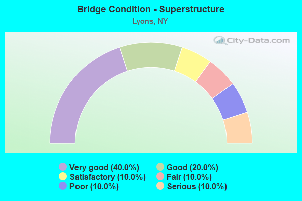
- Bridge Condition - Superstructure
- 40.0%Very good
- 20.0%Good
- 10.0%Satisfactory
- 10.0%Fair
- 10.0%Poor
- 10.0%Serious
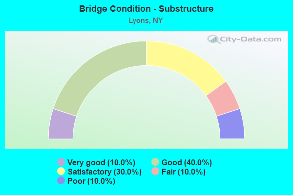
- Bridge Condition - Substructure
- 10.0%Very good
- 40.0%Good
- 30.0%Satisfactory
- 10.0%Fair
- 10.0%Poor
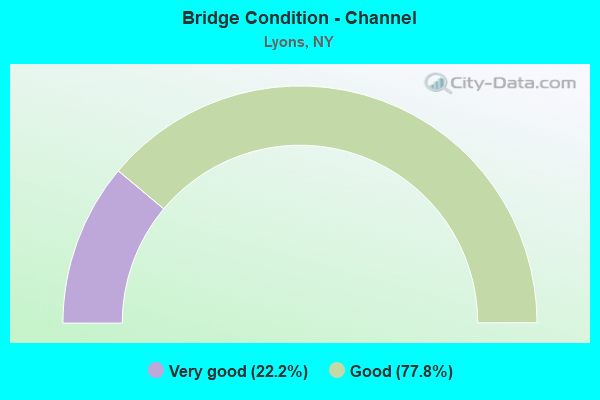
- Bridge Condition - Channel
- 22.2%Very good
- 77.8%Good
Find on map >> Show street view
Structure Number: 101102, Location: .1 MI S JCT SH 14 & SH 31 (Lat: 43.057464, Lng: -76.993128), Route carried "on" structure: State highway 14, Year Built: 1976, Status: Open, Structure Length: 11.67m (38.29ft), Average Daily Traffic: 4,623 (year 2020), Truck Traffic: 18%, Average Future Daily Traffic: 4,644 (year 2040), Design Load: HS 20, Features Intersected: DEPEW AVENUE, CSX TRANS/
Minimum Vertical Clearance: 30+ m (98+ ft), Kilometerpoint: 5.149, Lanes on structure: 2, Lanes under structure: 2, Base Highway Network: Yes, Owner: State Highway Agency, Approaching Roadway Width: 9.1m (29.9ft), Material/Design: Steel, Design/Construction: Stringer/Multi-beam, Number Of Spans In Main Unit: 4, Length of Maximum Span: 35.9m (117.8ft), Curb or Sidewalk Widths: Left: 1.2m (3.9ft), Right: 1.2m (3.9ft), Curb-To-Curb Width: 9.1m (29.9ft), Out-to-Out Width: 12.2m (40.0ft)
Condition: Deck: Fair, Superstructure: Good, Substructure: Fair, Inventory Rating: 64.4 metric tons, Method Used To Determine Inventory Rating: Load Factor (LF), Structural Evaluation: Somewhat better than minimum adequacy, Deck Geometry: Meets minimum limits, Underclear: Superior to present desirable criteria, Approach Roadway Alignment: Equal to present desirable criteria, Length Of Structure Improvement: 11.67m (38.29ft), Designated Inspection Frequency: Every 24 months, Inspection Date: August 2020, Bridge Improvement Cost: $3,415,000, Roadway Improvement Cost: $2,000,000, Total Project Cost: $5,415,000 ( Estimate for 2021), Deck Structure Type: Concrete Cast-file-Place, Wearing Surface/Protective System: Wearing Surface: Integral Concrete
Find on map >> Show street view
Structure Number: 102175, Location: .3 MI W JCT SH 31 & SH 14 (Lat: 43.060508, Lng: -76.997192), Route carried "on" structure: State highway 31, Year Built: 1936, Year Reconstructed: 2009, Status: Open, Structure Length: 2.65m (8.69ft), Average Daily Traffic: 9,148 (year 2020), Truck Traffic: 5%, Average Future Daily Traffic: 9,190 (year 2040), Design Load: HL 93, Features Intersected: CANANDAIGUA OUTLT
Minimum Vertical Clearance: 30+ m (98+ ft), Kilometerpoint: 14.063, Lanes on structure: 2, Base Highway Network: Yes, Owner: State Highway Agency, Approaching Roadway Width: 10.4m (34.1ft), Skew: 21 degrees, Material/Design: Prestressed concrete, Design/Construction: Stringer/Multi-beam, Number Of Spans In Main Unit: 1, Length of Maximum Span: 25.9m (85.0ft), Curb or Sidewalk Widths: Left: 1.6m (5.2ft), Right: 0.0m, Curb-To-Curb Width: 10.4m (34.1ft), Out-to-Out Width: 13.0m (42.7ft)
Condition: Deck: Very good, Superstructure: Very good, Substructure: Good, Channel: Good, Inventory Rating: 67.1 metric tons, Method Used To Determine Inventory Rating: Load Factor (LF), Structural Evaluation: Better than present minimum criteria, Deck Geometry: Meets minimum limits, Waterway Adequacy: Equal to present minimum criteria, Approach Roadway Alignment: Equal to present desirable criteria, Length Of Structure Improvement: 2.65m (8.69ft), Designated Inspection Frequency: Every 24 months, Underwater Inspection Frequency: Every 60 months, Inspection Date: August 2021, Underwater Inspection Date: August 2014, Bridge Improvement Cost: $1,273,000, Roadway Improvement Cost: $745,000, Total Project Cost: $2,018,000 ( Estimate for 2021), Wearing Surface/Protective System: Wearing Surface: Bituminous, Membrane: Other
Find on map >> Show street view
Structure Number: 107927, Location: 1.3 miles West of Rte 14 (Lat: 43.060292, Lng: -77.016283), Route carried "on" structure: State highway , Year Built: 2013, Status: Open, Structure Length: 0.76m (2.49ft), Average Daily Traffic: 9,100 (year 2011), Truck Traffic: 13%, Average Future Daily Traffic: 8,050 (year 2036), Design Load: HS 25 or greater, Features Intersected: RTE 31, Facility Carried by Structure: State highway 3706
Minimum Vertical Clearance: 30+ m (98+ ft), Kilometerpoint: 127.111, Lanes on structure: 2, Owner: State Highway Agency, Approaching Roadway Width: 13.1m (43.0ft), Material/Design: Concrete, Design/Construction: Culvert, Number Of Spans In Main Unit: 1, Length of Maximum Span: 7.0m (23.0ft)
Condition: Channel: Good, Culverts: Good, Inventory Rating: 94.3 metric tons, Method Used To Determine Inventory Rating: Load Factor (LF), Structural Evaluation: Better than present minimum criteria, Waterway Adequacy: Equal to present minimum criteria, Approach Roadway Alignment: Equal to present desirable criteria, Length Of Structure Improvement: 0.76m (2.49ft), Designated Inspection Frequency: Every 24 months, Inspection Date: November 2021, Bridge Improvement Cost: $179,000, Roadway Improvement Cost: $105,000, Total Project Cost: $284,000 ( Estimate for 2021)
Find on map >> Show street view
Structure Number: 220767, Location: 0.5 MI W OF LYONS (Lat: 43.063928, Lng: -77.003308), Route carried "on" structure: Other road , Year Built: 2011, Status: Open, Structure Length: 3.47m (11.38ft), Average Daily Traffic: 1,775 (year 2017), Truck Traffic: 7%, Average Future Daily Traffic: 2,485 (year 2037), Design Load: HL 93, Features Intersected: GANARGUA CREEK, Facility Carried by Structure: WATER STREET
Minimum Vertical Clearance: 30+ m (98+ ft), Kilometerpoint: 0.740, Lanes on structure: 2, Owner: County Highway Agency, Approaching Roadway Width: 9.1m (29.9ft), Material/Design: Steel, Design/Construction: Stringer/Multi-beam, Number Of Spans In Main Unit: 1, Length of Maximum Span: 34.1m (111.9ft), Curb-To-Curb Width: 9.1m (29.9ft), Out-to-Out Width: 10.4m (34.1ft)
Condition: Deck: Very good, Superstructure: Very good, Substructure: Very good, Channel: Very good, Operating Rating: 77.1 metric tons, Method Used To Determine Operating Rating: Load Factor (LF), Inventory Rating: 46.3 metric tons, Method Used To Determine Inventory Rating: Load Factor (LF), Structural Evaluation: Equal to present desirable criteria, Deck Geometry: Somewhat better than minimum adequacy, Waterway Adequacy: Superior to present desirable criteria, Approach Roadway Alignment: Equal to present desirable criteria, Length Of Structure Improvement: 3.47m (11.38ft), Designated Inspection Frequency: Every 24 months, Inspection Date: May 2021, Bridge Improvement Cost: $904,000, Roadway Improvement Cost: $530,000, Total Project Cost: $1,434,000 ( Estimate for 2021), Deck Structure Type: Concrete Cast-file-Place, Wearing Surface/Protective System: Wearing Surface: Integral Concrete, Deck Protection: Epoxy Coated Reinforcing
Find on map >> Show street view
Structure Number: 225776, Location: 1.2 MILES SE OF LYONS (Lat: 43.055758, Lng: -76.975411), Route carried "on" structure: County highway , Year Built: 1993, Status: Open, Structure Length: 3.51m (11.52ft), Average Daily Traffic: 897 (year 2018), Truck Traffic: 16%, Average Future Daily Traffic: 1,109 (year 2040), Design Load: HS 20, Features Intersected: CSX TRANS/AMTRAK, Facility Carried by Structure: COUNTY ROAD 344
Minimum Vertical Clearance: 30+ m (98+ ft), Kilometerpoint: 0.660, Lanes on structure: 2, Owner: Town or Township Highway Agency, Approaching Roadway Width: 9.1m (29.9ft), Skew: 2 degrees, Material/Design: Steel, Design/Construction: Stringer/Multi-beam, Number Of Spans In Main Unit: 1, Length of Maximum Span: 33.5m (109.9ft), Curb-To-Curb Width: 9.0m (29.5ft), Out-to-Out Width: 9.9m (32.5ft)
Condition: Deck: Very good, Superstructure: Very good, Substructure: Satisfactory, Operating Rating: 89.8 metric tons, Method Used To Determine Operating Rating: Load Factor (LF), Inventory Rating: 37.2 metric tons, Method Used To Determine Inventory Rating: Load Factor (LF), Structural Evaluation: Equal to present minimum criteria, Deck Geometry: Somewhat better than minimum adequacy, Underclear: Somewhat better than minimum adequacy, Approach Roadway Alignment: Equal to present desirable criteria, Length Of Structure Improvement: 3.50m (11.48ft), Designated Inspection Frequency: Every 24 months, Inspection Date: July 2021, Bridge Improvement Cost: $1,668,000, Roadway Improvement Cost: $977,000, Total Project Cost: $2,644,000 ( Estimate for 2021), Deck Structure Type: Concrete Cast-file-Place, Wearing Surface/Protective System: Wearing Surface: Integral Concrete, Deck Protection: Epoxy Coated Reinforcing
Find on map >> Show street view
Structure Number: 331477, Location: .2 MILE WEST OF ALLOWAY (Lat: 43.023194, Lng: -76.989889), Route carried "on" structure: County highway , Year Built: 1930, Year Reconstructed: 1987, Status: Open, Structure Length: 3.08m (10.10ft), Average Daily Traffic: 517 (year 2017), Truck Traffic: 5%, Average Future Daily Traffic: 724 (year 2037), Design Load: HS 20, Features Intersected: CANANDAIGUA OUTLT, Facility Carried by Structure: ALLOWAY ROAD
Minimum Vertical Clearance: 30+ m (98+ ft), Kilometerpoint: 2.397, Lanes on structure: 2, Owner: County Highway Agency, Approaching Roadway Width: 8.8m (28.9ft), Material/Design: Steel, Design/Construction: Stringer/Multi-beam, Number Of Spans In Main Unit: 1, Length of Maximum Span: 30.4m (99.7ft), Curb-To-Curb Width: 8.5m (27.9ft), Out-to-Out Width: 9.2m (30.2ft)
Condition: Deck: Good, Superstructure: Good, Substructure: Satisfactory, Channel: Good, Operating Rating: 99.8 metric tons, Method Used To Determine Operating Rating: Load Factor (LF), Inventory Rating: 59.0 metric tons, Method Used To Determine Inventory Rating: Load Factor (LF), Structural Evaluation: Equal to present minimum criteria, Deck Geometry: Somewhat better than minimum adequacy, Waterway Adequacy: Equal to present desirable criteria, Approach Roadway Alignment: Meets minimum limits, Length Of Structure Improvement: 3.07m (10.07ft), Designated Inspection Frequency: Every 24 months, Inspection Date: June 2021, Bridge Improvement Cost: $826,000, Roadway Improvement Cost: $483,000, Total Project Cost: $1,309,000 ( Estimate for 2021), Deck Structure Type: Concrete Cast-file-Place, Wearing Surface/Protective System: Wearing Surface: Integral Concrete, Deck Protection: Epoxy Coated Reinforcing
Find on map >> Show street view
Structure Number: 331822, Location: 3.9 MI NE OF OAKS COR. (Lat: 42.983533, Lng: -76.981719), Route carried "on" structure: Other road , Year Built: 1967, Status: Open, Structure Length: 3.32m (10.89ft), Average Daily Traffic: 135 (year 2017), Truck Traffic: 5%, Average Future Daily Traffic: 189 (year 2037), Design Load: HS 20, Features Intersected: CANANDAIGUA OUTLT, Facility Carried by Structure: GIFFORD ROAD
Minimum Vertical Clearance: 30+ m (98+ ft), Kilometerpoint: 7.257, Lanes on structure: 2, Owner: County Highway Agency, Approaching Roadway Width: 6.7m (22.0ft), Skew: 3 degrees, Material/Design: Steel, Design/Construction: Stringer/Multi-beam, Number Of Spans In Main Unit: 2, Length of Maximum Span: 15.8m (51.8ft), Curb-To-Curb Width: 8.2m (26.9ft), Out-to-Out Width: 8.8m (28.9ft)
Condition: Deck: Satisfactory, Superstructure: Satisfactory, Substructure: Good, Channel: Good, Operating Rating: 96.2 metric tons, Method Used To Determine Operating Rating: Load and Resistance Factor Rating (LRFR) rating reported by rating factor(RF) method using HL-93 loadings, Inventory Rating: 74.2 metric tons, Method Used To Determine Inventory Rating: Load and Resistance Factor Rating (LRFR) rating reported by rating factor(RF) method using HL-93 loadings, Structural Evaluation: Equal to present minimum criteria, Deck Geometry: Somewhat better than minimum adequacy, Waterway Adequacy: Equal to present desirable criteria, Approach Roadway Alignment: Equal to present desirable criteria, Length Of Structure Improvement: 3.32m (10.89ft), Designated Inspection Frequency: Every 24 months, Inspection Date: June 2021, Bridge Improvement Cost: $966,000, Roadway Improvement Cost: $566,000, Total Project Cost: $1,532,000 ( Estimate for 2021), Deck Structure Type: Concrete Cast-file-Place, Wearing Surface/Protective System: Wearing Surface: Bituminous, Membrane: Other
Find on map >> Show street view
Structure Number: 401103, Location: JCT OF RTE 14 + ERIE CANL (Lat: 43.060981, Lng: -76.992039), Route carried "on" structure: State highway 14, Year Built: 1991, Status: Open, Structure Length: 5.64m (18.50ft), Average Daily Traffic: 8,568 (year 2020), Truck Traffic: 7%, Average Future Daily Traffic: 10,408 (year 2040), Design Load: HS 20, Features Intersected: ERIE CANAL
Minimum Vertical Clearance: 30+ m (98+ ft), Kilometerpoint: 5.471, Lanes on structure: 2, Base Highway Network: Yes, Owner: State Highway Agency, Approaching Roadway Width: 8.5m (27.9ft), Navigation Control: Yes ( Vertical Clearance: 4.5m (14.8ft), Horizontal Clearance: 30.4m (99.7ft)), Material/Design: Steel, Design/Construction: Stringer/Multi-beam, Number Of Spans In Main Unit: 1, Length of Maximum Span: 54.8m (179.8ft), Curb or Sidewalk Widths: Left: 1.5m (4.9ft), Right: 1.5m (4.9ft), Curb-To-Curb Width: 8.5m (27.9ft), Out-to-Out Width: 12.2m (40.0ft)
Condition: Deck: Good, Superstructure: Very good, Substructure: Good, Channel: Good, Operating Rating: 84.4 metric tons, Method Used To Determine Operating Rating: Load Factor (LF), Inventory Rating: 32.7 metric tons, Method Used To Determine Inventory Rating: Load Factor (LF), Structural Evaluation: Better than present minimum criteria, Deck Geometry: High priority of replacement, Waterway Adequacy: Equal to present desirable criteria, Approach Roadway Alignment: Equal to present desirable criteria, Length Of Structure Improvement: 5.63m (18.47ft), Designated Inspection Frequency: Every 24 months, Inspection Date: June 2021, Bridge Improvement Cost: $1,999,000, Roadway Improvement Cost: $1,171,000, Total Project Cost: $3,170,000 ( Estimate for 2021), Deck Structure Type: Concrete Cast-file-Place, Wearing Surface/Protective System: Wearing Surface: Integral Concrete, Deck Protection: Epoxy Coated Reinforcing
Find on map >> Show street view
Structure Number: 402176, Location: JCT OF RTE 31 + BARGE C (Lat: 43.059822, Lng: -76.982731), Route carried "on" structure: State highway 31, Year Built: 1965, Status: Open, Structure Length: 11.86m (38.91ft), Average Daily Traffic: 4,338 (year 2018), Truck Traffic: 6%, Average Future Daily Traffic: 5,269 (year 2040), Design Load: HS 20, Features Intersected: ERIE CANAL
Minimum Vertical Clearance: 30+ m (98+ ft), Kilometerpoint: 15.253, Lanes on structure: 2, Base Highway Network: Yes, Owner: State Highway Agency, Approaching Roadway Width: 11.6m (38.1ft), Skew: 3 degrees, Navigation Control: Yes ( Vertical Clearance: 6.0m (19.7ft), Horizontal Clearance: 31.6m (103.7ft)), Material/Design: Steel continuous, Design/Construction: Stringer/Multi-beam, Number Of Spans In Main Unit: 3, Length of Maximum Span: 49.9m (163.7ft), Curb or Sidewalk Widths: Left: 0.5m (1.6ft), Right: 0.5m (1.6ft), Curb-To-Curb Width: 8.5m (27.9ft), Out-to-Out Width: 10.1m (33.1ft)
Condition: Deck: Fair, Superstructure: Fair, Substructure: Good, Channel: Good, Operating Rating: 62.6 metric tons, Method Used To Determine Operating Rating: Load Factor (LF), Inventory Rating: 37.2 metric tons, Method Used To Determine Inventory Rating: Load Factor (LF), Structural Evaluation: Somewhat better than minimum adequacy, Deck Geometry: Meets minimum limits, Waterway Adequacy: Somewhat better than minimum adequacy, Approach Roadway Alignment: Equal to present desirable criteria, Length Of Structure Improvement: 11.85m (38.88ft), Designated Inspection Frequency: Every 24 months, Underwater Inspection Frequency: Every 60 months, Inspection Date: August 2020, Underwater Inspection Date: August 2017, Bridge Improvement Cost: $2,748,000, Roadway Improvement Cost: $1,609,000, Total Project Cost: $4,358,000 ( Estimate for 2021), Deck Structure Type: Concrete Cast-file-Place, Wearing Surface/Protective System: Wearing Surface: Bituminous, Deck Protection: Other Coated Reinforcing
Find on map >> Show street view
Structure Number: 443706, Location: 0.2 MI NW JCT RTE 414 + C (Lat: 43.061794, Lng: -76.996622), Route carried "on" structure: Alternate City street , Year Built: 1919, Year Reconstructed: 1990, Status: Posted for load, Structure Length: 6.64m (21.78ft), Average Daily Traffic: 2,808 (year 2017), Truck Traffic: 2%, Average Future Daily Traffic: 3,474 (year 2040), Design Load: HS 20, Features Intersected: Canal Trailway, ERIE CAN, Facility Carried by Structure: LEACH STREET
Minimum Vertical Clearance: 4.24m (13.91ft), Kilometerpoint: 0.064, Lanes on structure: 2, Owner: State Highway Agency, Approaching Roadway Width: 6.4m (21.0ft), Navigation Control: Yes ( Vertical Clearance: 4.8m (15.7ft), Horizontal Clearance: 23.1m (75.8ft)), Material/Design: Steel, Design/Construction: Truss - Thru, Number Of Spans In Main Unit: 1, Number Of Approach Spans: 1, Length of Maximum Span: 41.4m (135.8ft), Curb or Sidewalk Widths: Left: 0.0m, Right: 1.8m (5.9ft), Curb-To-Curb Width: 5.4m (17.7ft), Out-to-Out Width: 6.2m (20.3ft)
Condition: Deck: Fair, Superstructure: Poor, Substructure: Satisfactory, Channel: Very good, Operating Rating: 20.0 metric tons, Method Used To Determine Operating Rating: Load Factor (LF), Inventory Rating: 11.8 metric tons, Method Used To Determine Inventory Rating: Load Factor (LF), Structural Evaluation: High priority of corrective action, Deck Geometry: High priority of replacement, Waterway Adequacy: Equal to present desirable criteria, Approach Roadway Alignment: Meets minimum limits, Bridge Posting: Required (Relationship of Operating Rating to Maximum Legal Load: > 39.9% below), Length Of Structure Improvement: 6.64m (21.78ft), Designated Inspection Frequency: Every 12 months, Critical Feature Inspection Frequency: Every 12 months, Underwater Inspection Frequency: Every 60 months, Inspection Date: August 2021, Critical Feature Inspection Date: August 2021, Underwater Inspection Date: July 2020, Bridge Improvement Cost: $3,945,000, Roadway Improvement Cost: $2,310,000, Total Project Cost: $6,255,000 ( Estimate for 2021), Deck Structure Type: Open Grating, Wearing Surface/Protective System: Wearing Surface: Other
Find on map >> Show street view
Structure Number: 443708, Location: 1.3 MI W JCT RTE 414 (Lat: 43.062106, Lng: -77.019061), Route carried "on" structure: Other road , Year Built: 1919, Status: Closed, Structure Length: 4.54m (14.90ft), Average Daily Traffic: 317 (year 2017), Truck Traffic: 2%, Average Future Daily Traffic: 444 (year 2037), Features Intersected: ERIE CANAL, Facility Carried by Structure: DRY DOCK ROAD
Minimum Vertical Clearance: 30+ m (98+ ft), Kilometerpoint: 1.175, Lanes on structure: 2, Owner: State Highway Agency, Approaching Roadway Width: 7.3m (24.0ft), Skew: 2 degrees, Navigation Control: Yes ( Vertical Clearance: 5.1m (16.7ft), Horizontal Clearance: 26.5m (86.9ft)), Material/Design: Steel, Design/Construction: Girder and Floorbeam System, Number Of Spans In Main Unit: 1, Number Of Approach Spans: 2, Length of Maximum Span: 26.5m (86.9ft), Curb-To-Curb Width: 5.5m (18.0ft), Out-to-Out Width: 6.6m (21.7ft)
Condition: Deck: Poor, Superstructure: Serious, Substructure: Poor, Channel: Good, Deck Geometry: High priority of corrective action, Waterway Adequacy: Superior to present desirable criteria, Approach Roadway Alignment: High priority of replacement, Bridge Posting: Required (Relationship of Operating Rating to Maximum Legal Load: > 39.9% below), Length Of Structure Improvement: 4.54m (14.90ft), Designated Inspection Frequency: Every 12 months, Critical Feature Inspection Frequency: Every 12 months, Inspection Date: June 2021, Critical Feature Inspection Date: June 2021, Bridge Improvement Cost: $957,000, Roadway Improvement Cost: $560,000, Total Project Cost: $1,517,000 ( Estimate for 2021), Wearing Surface/Protective System: Wearing Surface: Integral Concrete
Find on map >> Show street view
Structure Number: 101102, Location: .1 MI S JCT SH 14 & SH 31 (Lat: 43.057464, Lng: -76.993128), Route carried "under" structure: Other road , Year Built: 1976, Structure Length: 0. m, Average Daily Traffic: 100 (year 2021), Features Intersected: DEPEW AVENUE, CSX TRANS/, Facility Carried by Structure: RTE 14
Minimum Vertical Clearance: 7.92m (25.98ft), Kilometerpoint: 0.000, Lanes on structure: 2, Lanes under structure: 2, Material/Design: Steel, Design/Construction: Stringer/Multi-beam, Length of Maximum Span: 35.9m (117.8ft)