Bridge Statistics for Lyons, Colorado (CO)
Condition, Traffic, Stress, Structural Evaluation, Project Costs
- National Bridge Inventory (NBI) Statistics
- 18Number of bridges
- 141ft / 43.0mTotal length
- 69,398Total average daily traffic
- 2,733Total average daily truck traffic
- 86,907Total future (year 2040) average daily traffic
- National Bridge Inventory (NBI) Registered Bridges for Lyons
- No street view available for this location
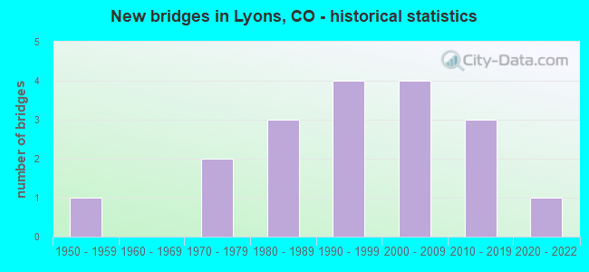
- New bridges - historical statistics
- 11950-1959
- 21970-1979
- 31980-1989
- 41990-1999
- 42000-2009
- 32010-2019
- 12020-2022
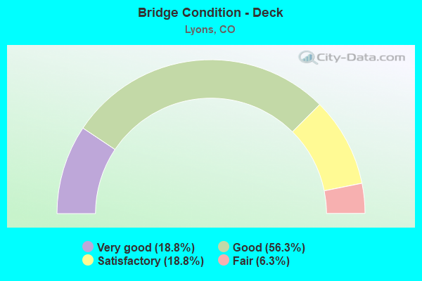
- Bridge Condition - Deck
- 18.8%Very good
- 56.3%Good
- 18.8%Satisfactory
- 6.3%Fair
- Bridge Condition - Superstructure
- 31.3%Very good
- 43.8%Good
- 12.5%Satisfactory
- 12.5%Fair
- Bridge Condition - Substructure
- 31.3%Very good
- 31.3%Good
- 31.3%Satisfactory
- 6.3%Fair
- Bridge Condition - Channel
- 50.0%Very good
- 33.3%Good
- 11.1%Satisfactory
- 5.6%Poor
Find on map >> Show street view
Structure Number: BC-10-0.8-ID1, Location: 0.7 Mi E of US Hwy 36 (Lat: 40.188881, Lng: -105.238842), Route carried "on" structure: County highway , Year Built: 1987, Status: Open, Structure Length: 0.88m (2.89ft), Average Daily Traffic: 1,243 (year 2021), Truck Traffic: 5%, Average Future Daily Traffic: 1,492 (year 2041), Design Load: HS 20, Features Intersected: Boulder Feeder Ditch, Facility Carried by Structure: Hygiene Rd (Cr 10)
Minimum Vertical Clearance: 30+ m (98+ ft), Kilometerpoint: 1.090, Lanes on structure: 2, Owner: County Highway Agency, Approaching Roadway Width: 7.3m (24.0ft), Material/Design: Concrete, Design/Construction: Frame, Number Of Spans In Main Unit: 1, Length of Maximum Span: 8.2m (26.9ft), Curb-To-Curb Width: 11.7m (38.4ft), Out-to-Out Width: 12.3m (40.4ft)
Condition: Deck: Satisfactory, Superstructure: Satisfactory, Substructure: Good, Channel: Very good, Operating Rating: 83.8 metric tons, Method Used To Determine Operating Rating: Load Factor (LF), Inventory Rating: 50.3 metric tons, Method Used To Determine Inventory Rating: Load Factor (LF), Structural Evaluation: Equal to present minimum criteria, Deck Geometry: Equal to present minimum criteria, Waterway Adequacy: Equal to present desirable criteria, Approach Roadway Alignment: Equal to present desirable criteria, Designated Inspection Frequency: Every 24 months, Inspection Date: January 2021, Deck Structure Type: Concrete Cast-file-Place, Wearing Surface/Protective System: Wearing Surface: Bituminous
Find on map >> Show street view
Structure Number: BC-16-1.9-ID, Location: 0.5 Mi E of Co Rd 51 (Lat: 40.174267, Lng: -105.226953), Route carried "on" structure: County highway , Year Built: 1955, Year Reconstructed: 1983, Status: Open, Structure Length: 0.87m (2.85ft), Average Daily Traffic: 1,041 (year 2021), Truck Traffic: 8%, Average Future Daily Traffic: 1,249 (year 2041), Design Load: HS 20, Features Intersected: Boulder Feeder Ditch, Facility Carried by Structure: St Vrain Road CR16
Minimum Vertical Clearance: 30+ m (98+ ft), Kilometerpoint: 2.955, Lanes on structure: 2, Owner: County Highway Agency, Approaching Roadway Width: 7.0m (23.0ft), Material/Design: Prestressed concrete, Design/Construction: Tee Beam, Number Of Spans In Main Unit: 1, Length of Maximum Span: 8.1m (26.6ft), Curb-To-Curb Width: 7.8m (25.6ft), Out-to-Out Width: 8.7m (28.5ft)
Condition: Deck: Fair, Superstructure: Fair, Substructure: Satisfactory, Channel: Very good, Operating Rating: 32.7 metric tons, Method Used To Determine Operating Rating: Load Factor (LF), Inventory Rating: 22.7 metric tons, Method Used To Determine Inventory Rating: Load Factor (LF), Structural Evaluation: Somewhat better than minimum adequacy, Deck Geometry: Meets minimum limits, Waterway Adequacy: Equal to present minimum criteria, Approach Roadway Alignment: Equal to present desirable criteria, Designated Inspection Frequency: Every 24 months, Inspection Date: Febuary 2021, Deck Structure Type: Other, Wearing Surface/Protective System: Wearing Surface: Bituminous
Find on map >> Show street view
Structure Number: BC-41-1.4-SV1, Location: 0.5 Mi N of Co Rd 10 (Lat: 40.195994, Lng: -105.207864), Route carried "on" structure: County highway , Year Built: 1991, Status: Open, Structure Length: 1.80m (5.91ft), Average Daily Traffic: 202 (year 2021), Truck Traffic: 6%, Average Future Daily Traffic: 242 (year 2041), Design Load: HS 20, Features Intersected: St. Vrain Creek, Facility Carried by Structure: C. R. 41 (63rd St)
Minimum Vertical Clearance: 30+ m (98+ ft), Kilometerpoint: 0.888, Lanes on structure: 2, Owner: County Highway Agency, Approaching Roadway Width: 7.3m (24.0ft), Material/Design: Prestressed concrete, Design/Construction: Box Beam or Girders - Single/Spread, Number Of Spans In Main Unit: 1, Length of Maximum Span: 16.4m (53.8ft), Curb-To-Curb Width: 9.8m (32.2ft), Out-to-Out Width: 10.5m (34.4ft)
Condition: Deck: Good, Superstructure: Satisfactory, Substructure: Satisfactory, Channel: Good, Operating Rating: 40.5 metric tons, Method Used To Determine Operating Rating: Load Factor (LF), Inventory Rating: 24.3 metric tons, Method Used To Determine Inventory Rating: Load Factor (LF), Structural Evaluation: Equal to present minimum criteria, Deck Geometry: Better than present minimum criteria, Waterway Adequacy: Equal to present desirable criteria, Approach Roadway Alignment: Equal to present minimum criteria, Designated Inspection Frequency: Every 24 months, Inspection Date: January 2021, Deck Structure Type: Concrete Cast-file-Place, Wearing Surface/Protective System: Wearing Surface: Bituminous, Membrane: Preformed Fabric, Deck Protection: Epoxy Coated Reinforcing
Find on map >> Show street view
Structure Number: BC-47-0.1-ID1, Location: 2.7 Mi N of St Hwy 66 (Lat: 40.245794, Lng: -105.225047), Route carried "on" structure: County highway , Year Built: 1997, Status: Open, Structure Length: 1.65m (5.41ft), Average Daily Traffic: 441 (year 2021), Truck Traffic: 16%, Average Future Daily Traffic: 529 (year 2041), Design Load: HS 20, Features Intersected: St. Vrain Supply Canal, Facility Carried by Structure: County Road 47
Minimum Vertical Clearance: 30+ m (98+ ft), Kilometerpoint: 2.905, Lanes on structure: 2, Owner: County Highway Agency, Approaching Roadway Width: 7.0m (23.0ft), Material/Design: Prestressed concrete, Design/Construction: Box Beam or Girders - Single/Spread, Number Of Spans In Main Unit: 1, Length of Maximum Span: 15.0m (49.2ft), Curb-To-Curb Width: 10.2m (33.5ft), Out-to-Out Width: 11.4m (37.4ft)
Condition: Deck: Good, Superstructure: Good, Substructure: Good, Channel: Very good, Operating Rating: 29.7 metric tons, Method Used To Determine Operating Rating: Load Factor (LF), Inventory Rating: 18.7 metric tons, Method Used To Determine Inventory Rating: Load Factor (LF), Structural Evaluation: Somewhat better than minimum adequacy, Deck Geometry: Equal to present minimum criteria, Waterway Adequacy: Equal to present desirable criteria, Approach Roadway Alignment: Equal to present desirable criteria, Designated Inspection Frequency: Every 24 months, Inspection Date: January 2021, Deck Structure Type: Concrete Cast-file-Place, Wearing Surface/Protective System: Wearing Surface: Bituminous, Deck Protection: Epoxy Coated Reinforcing
Find on map >> Show street view
Structure Number: BC-71-2.4-NSV1, Location: 30 Ft So of US Hwy 36 (Lat: 40.247775, Lng: -105.289586), Route carried "on" structure: County highway , Year Built: 1991, Status: Open, Structure Length: 2.32m (7.61ft), Average Daily Traffic: 282 (year 2021), Truck Traffic: 10%, Average Future Daily Traffic: 338 (year 2041), Design Load: HS 20, Features Intersected: North St. Vrain Creek, Facility Carried by Structure: County Road 71
Minimum Vertical Clearance: 5.12m (16.80ft), Kilometerpoint: 3.142, Lanes on structure: 2, Owner: County Highway Agency, Approaching Roadway Width: 7.3m (24.0ft), Material/Design: Wood or Timber, Design/Construction: Arch - Thru, Number Of Spans In Main Unit: 1, Length of Maximum Span: 20.4m (66.9ft), Curb-To-Curb Width: 9.8m (32.2ft), Out-to-Out Width: 10.0m (32.8ft)
Condition: Deck: Good, Superstructure: Good, Substructure: Very good, Channel: Very good, Operating Rating: 66.2 metric tons, Method Used To Determine Operating Rating: Load Factor (LF), Inventory Rating: 47.0 metric tons, Method Used To Determine Inventory Rating: Load Factor (LF), Structural Evaluation: Better than present minimum criteria, Deck Geometry: Better than present minimum criteria, Waterway Adequacy: Better than present minimum criteria, Approach Roadway Alignment: Equal to present minimum criteria, Designated Inspection Frequency: Every 24 months, Critical Feature Inspection Frequency: Every 24 months, Other Special Inspection Frequency: Every 60 months, Inspection Date: July 2021, Critical Feature Inspection Date: January 2021, Other Special Inspection Date: July 2021, Deck Structure Type: Wood or Timber, Wearing Surface/Protective System: Wearing Surface: Bituminous
Find on map >> Show street view
Structure Number: BC-80-0.1-NSV1, Location: 20 Ft S of US Hwy 36 (Lat: 40.242911, Lng: -105.313742), Route carried "on" structure: County highway , Year Built: 1988, Status: Open, Structure Length: 1.87m (6.14ft), Average Daily Traffic: 265 (year 2021), Truck Traffic: 18%, Average Future Daily Traffic: 318 (year 2041), Design Load: HS 20, Features Intersected: North St. Vrain Creek, Facility Carried by Structure: County Road 80
Minimum Vertical Clearance: 30+ m (98+ ft), Kilometerpoint: 4.318, Lanes on structure: 2, Owner: County Highway Agency, Approaching Roadway Width: 7.9m (25.9ft), Skew: 3 degrees, Material/Design: Prestressed concrete, Design/Construction: Box Beam or Girders - Single/Spread, Number Of Spans In Main Unit: 1, Length of Maximum Span: 16.6m (54.5ft), Curb-To-Curb Width: 8.5m (27.9ft), Out-to-Out Width: 9.4m (30.8ft)
Condition: Deck: Satisfactory, Superstructure: Good, Substructure: Good, Channel: Good, Operating Rating: 57.4 metric tons, Method Used To Determine Operating Rating: Load Factor (LF), Inventory Rating: 34.5 metric tons, Method Used To Determine Inventory Rating: Load Factor (LF), Structural Evaluation: Better than present minimum criteria, Deck Geometry: Equal to present minimum criteria, Waterway Adequacy: Equal to present desirable criteria, Approach Roadway Alignment: Equal to present minimum criteria, Designated Inspection Frequency: Every 24 months, Inspection Date: January 2021, Deck Structure Type: Concrete Cast-file-Place, Wearing Surface/Protective System: Wearing Surface: Bituminous, Deck Protection: Epoxy Coated Reinforcing
Find on map >> Show street view
Structure Number: BC-80-0.8-NSV1, Location: 0.8 Mi W of US Hwy 36 (Lat: 40.236778, Lng: -105.319161), Route carried "on" structure: County highway , Year Built: 1988, Status: Open, Structure Length: 1.53m (5.02ft), Average Daily Traffic: 197 (year 2021), Truck Traffic: 18%, Average Future Daily Traffic: 236 (year 2041), Design Load: HS 20, Features Intersected: North St. Vrain Creek, Facility Carried by Structure: County Road 80
Minimum Vertical Clearance: 30+ m (98+ ft), Kilometerpoint: 3.082, Lanes on structure: 2, Owner: County Highway Agency, Approaching Roadway Width: 6.7m (22.0ft), Material/Design: Prestressed concrete, Design/Construction: Box Beam or Girders - Single/Spread, Number Of Spans In Main Unit: 1, Length of Maximum Span: 14.5m (47.6ft), Curb-To-Curb Width: 7.1m (23.3ft), Out-to-Out Width: 8.3m (27.2ft)
Condition: Deck: Satisfactory, Superstructure: Good, Substructure: Fair, Channel: Poor, Operating Rating: 54.0 metric tons, Method Used To Determine Operating Rating: Load Factor (LF), Inventory Rating: 33.6 metric tons, Method Used To Determine Inventory Rating: Load Factor (LF), Structural Evaluation: Somewhat better than minimum adequacy, Deck Geometry: Meets minimum limits, Waterway Adequacy: Somewhat better than minimum adequacy, Approach Roadway Alignment: Better than present minimum criteria, Designated Inspection Frequency: Every 24 months, Inspection Date: January 2021, Deck Structure Type: Concrete Cast-file-Place, Wearing Surface/Protective System: Wearing Surface: Monolithic Concrete
Find on map >> Show street view
Structure Number: BC-84S-0.1-SSV1, Location: 0.1 Mi S of St Hwy 7 (Lat: 40.216847, Lng: -105.274311), Route carried "on" structure: County highway , Year Built: 1990, Status: Open, Structure Length: 1.77m (5.81ft), Average Daily Traffic: 961 (year 2021), Truck Traffic: 6%, Average Future Daily Traffic: 1,153 (year 2041), Design Load: HS 20, Features Intersected: South St. Vrain Creek, Facility Carried by Structure: County Road 84S
Minimum Vertical Clearance: 30+ m (98+ ft), Kilometerpoint: 2.569, Lanes on structure: 2, Owner: County Highway Agency, Approaching Roadway Width: 7.3m (24.0ft), Skew: 3 degrees, Material/Design: Prestressed concrete, Design/Construction: Box Beam or Girders - Single/Spread, Number Of Spans In Main Unit: 1, Length of Maximum Span: 16.0m (52.5ft), Curb-To-Curb Width: 11.0m (36.1ft), Out-to-Out Width: 11.8m (38.7ft)
Condition: Deck: Good, Superstructure: Very good, Substructure: Satisfactory, Channel: Satisfactory, Operating Rating: 72.7 metric tons, Method Used To Determine Operating Rating: Load Factor (LF), Inventory Rating: 43.6 metric tons, Method Used To Determine Inventory Rating: Load Factor (LF), Structural Evaluation: Equal to present minimum criteria, Deck Geometry: Better than present minimum criteria, Waterway Adequacy: Equal to present desirable criteria, Approach Roadway Alignment: Equal to present minimum criteria, Designated Inspection Frequency: Every 24 months, Inspection Date: January 2021, Deck Structure Type: Concrete Cast-file-Place, Wearing Surface/Protective System: Wearing Surface: Bituminous, Deck Protection: Epoxy Coated Reinforcing
Find on map >> Show street view
Structure Number: BC-84S-1.6-SSV1, Location: 250 ft S of Hwy 7 (Lat: 40.206292, Lng: -105.293303), Route carried "on" structure: County highway , Year Built: 2019, Status: Open, Structure Length: 5.56m (18.24ft), Average Daily Traffic: 94 (year 2021), Truck Traffic: 4%, Average Future Daily Traffic: 113 (year 2041), Design Load: HL 93, Features Intersected: South St. Vrain Creek, Facility Carried by Structure: County Road 84S
Minimum Vertical Clearance: 30+ m (98+ ft), Kilometerpoint: 2.569, Lanes on structure: 2, Owner: County Highway Agency, Approaching Roadway Width: 8.5m (27.9ft), Material/Design: Steel, Design/Construction: Truss - Thru, Number Of Spans In Main Unit: 1, Length of Maximum Span: 53.7m (176.2ft), Curb-To-Curb Width: 9.1m (29.9ft), Out-to-Out Width: 10.1m (33.1ft)
Condition: Deck: Good, Superstructure: Fair, Substructure: Very good, Channel: Very good, Operating Rating: 32.7 metric tons, Method Used To Determine Operating Rating: No rating analysis performed, Inventory Rating: 32.7 metric tons, Method Used To Determine Inventory Rating: No rating analysis performed, Structural Evaluation: Somewhat better than minimum adequacy, Deck Geometry: Better than present minimum criteria, Waterway Adequacy: Equal to present desirable criteria, Approach Roadway Alignment: Equal to present desirable criteria, Designated Inspection Frequency: Every 24 months, Critical Feature Inspection Frequency: Every 24 months, Inspection Date: July 2021, Critical Feature Inspection Date: July 2021, Deck Structure Type: Concrete Cast-file-Place, Wearing Surface/Protective System: Wearing Surface: Bituminous
Find on map >> Show street view
Structure Number: D-15-BA, Location: IN LYONS (Lat: 40.229517, Lng: -105.276303), Route carried "on" structure: US 36B, Year Built: 2007, Status: Open, Structure Length: 2.70m (8.86ft), Average Daily Traffic: 9,000 (year 2020), Truck Traffic: 3%, Average Future Daily Traffic: 11,700 (year 2040), Design Load: HS 25 or greater, Features Intersected: NORTH ST VRAIN CREEK, Facility Carried by Structure: US 36 ML
Minimum Vertical Clearance: 30+ m (98+ ft), Kilometerpoint: 31.987, Lanes on structure: 2, Base Highway Network: Yes, Owner: State Highway Agency, Approaching Roadway Width: 11.9m (39.0ft), Skew: 1 degrees, Material/Design: Prestressed concrete, Design/Construction: Stringer/Multi-beam, Number Of Spans In Main Unit: 1, Length of Maximum Span: 26.2m (86.0ft), Curb or Sidewalk Widths: Left: 2.6m (8.5ft), Right: 0.0m, Curb-To-Curb Width: 11.9m (39.0ft), Out-to-Out Width: 15.5m (50.9ft)
Condition: Deck: Good, Superstructure: Very good, Substructure: Satisfactory, Channel: Good, Operating Rating: 61.4 metric tons, Method Used To Determine Operating Rating: Load Factor (LF), Inventory Rating: 36.8 metric tons, Method Used To Determine Inventory Rating: Load Factor (LF), Structural Evaluation: Equal to present minimum criteria, Deck Geometry: Somewhat better than minimum adequacy, Waterway Adequacy: Equal to present desirable criteria, Approach Roadway Alignment: Equal to present desirable criteria, Designated Inspection Frequency: Every 24 months, Inspection Date: August 2021, Deck Structure Type: Concrete Precast Panels, Wearing Surface/Protective System: Wearing Surface: Bituminous, Membrane: Built-up, Deck Protection: Epoxy Coated Reinforcing
Find on map >> Show street view
Structure Number: D-15-BB, Location: IN LYONS (Lat: 40.225681, Lng: -105.272503), Route carried "on" structure: US 36B, Year Built: 2007, Status: Open, Structure Length: 2.84m (9.32ft), Average Daily Traffic: 9,000 (year 2020), Truck Traffic: 3%, Average Future Daily Traffic: 11,700 (year 2040), Design Load: HS 25 or greater, Features Intersected: NORTH ST VRAIN CREEK, Facility Carried by Structure: US 36 ML
Minimum Vertical Clearance: 30+ m (98+ ft), Kilometerpoint: 32.520, Lanes on structure: 4, Base Highway Network: Yes, Owner: State Highway Agency, Approaching Roadway Width: 23.8m (78.1ft), Skew: 3 degrees, Material/Design: Prestressed concrete, Design/Construction: Box Beam or Girders - Multiple, Number Of Spans In Main Unit: 1, Length of Maximum Span: 27.5m (90.2ft), Curb or Sidewalk Widths: Left: 3.2m (10.5ft), Right: 0.0m, Curb-To-Curb Width: 23.8m (78.1ft), Out-to-Out Width: 27.9m (91.5ft)
Condition: Deck: Good, Superstructure: Good, Substructure: Good, Channel: Good, Operating Rating: 44.7 metric tons, Method Used To Determine Operating Rating: Load and Resistance Factor Rating (LRFR) rating reported by rating factor(RF) method using HL-93 loadings, Inventory Rating: 33.0 metric tons, Method Used To Determine Inventory Rating: Load and Resistance Factor Rating (LRFR) rating reported by rating factor(RF) method using HL-93 loadings, Structural Evaluation: Better than present minimum criteria, Deck Geometry: Superior to present desirable criteria, Waterway Adequacy: Equal to present desirable criteria, Approach Roadway Alignment: Equal to present desirable criteria, Length Of Structure Improvement: 1.95m (6.40ft), Designated Inspection Frequency: Every 24 months, Inspection Date: August 2021, Deck Structure Type: Concrete Cast-file-Place, Wearing Surface/Protective System: Wearing Surface: Bituminous, Membrane: Built-up, Deck Protection: Epoxy Coated Reinforcing
Find on map >> Show street view
Structure Number: D-15-BE, Location: IN LYONS (Lat: 40.219133, Lng: -105.261086), Route carried "on" structure: US 36B, Year Built: 1972, Status: Open, Structure Length: 0.69m (2.26ft), Average Daily Traffic: 15,000 (year 2020), Truck Traffic: 3%, Average Future Daily Traffic: 18,900 (year 2040), Design Load: HS 20, Features Intersected: SUPPLY DITCH, Facility Carried by Structure: US 36 ML
Minimum Vertical Clearance: 30+ m (98+ ft), Kilometerpoint: 33.862, Lanes on structure: 5, Owner: State Highway Agency, Approaching Roadway Width: 25.3m (83.0ft), Skew: 2 degrees, Material/Design: Concrete, Design/Construction: Culvert, Number Of Spans In Main Unit: 2, Length of Maximum Span: 3.3m (10.8ft), Out-to-Out Width: 27.8m (91.2ft)
Condition: Channel: Good, Culverts: Satisfactory, Operating Rating: 36.3 metric tons, Method Used To Determine Operating Rating: Field evaluation and documented engineering judgment, Inventory Rating: 32.7 metric tons, Method Used To Determine Inventory Rating: Field evaluation and documented engineering judgment, Structural Evaluation: Equal to present minimum criteria, Waterway Adequacy: Better than present minimum criteria, Approach Roadway Alignment: Equal to present desirable criteria, Designated Inspection Frequency: Every 24 months, Inspection Date: April 2021
Find on map >> Show street view
Structure Number: D-15-BF, Location: 1.2 MI SE OF JCT SH 7 LYO (Lat: 40.215172, Lng: -105.254828), Route carried "on" structure: US 36B, Year Built: 1972, Status: Open, Structure Length: 1.15m (3.77ft), Average Daily Traffic: 15,000 (year 2020), Truck Traffic: 3%, Average Future Daily Traffic: 18,900 (year 2040), Design Load: HS 20, Features Intersected: HIGHLAND CANAL, Facility Carried by Structure: US 36 ML
Minimum Vertical Clearance: 30+ m (98+ ft), Kilometerpoint: 34.562, Lanes on structure: 4, Base Highway Network: Yes, Owner: State Highway Agency, Approaching Roadway Width: 23.5m (77.1ft), Skew: 3 degrees, Material/Design: Concrete, Design/Construction: Culvert, Number Of Spans In Main Unit: 3, Length of Maximum Span: 4.4m (14.4ft), Curb-To-Curb Width: 23.7m (77.8ft), Out-to-Out Width: 28.1m (92.2ft)
Condition: Channel: Good, Culverts: Satisfactory, Operating Rating: 36.3 metric tons, Method Used To Determine Operating Rating: Field evaluation and documented engineering judgment, Inventory Rating: 32.7 metric tons, Method Used To Determine Inventory Rating: Field evaluation and documented engineering judgment, Structural Evaluation: Equal to present minimum criteria, Deck Geometry: Superior to present desirable criteria, Waterway Adequacy: Better than present minimum criteria, Approach Roadway Alignment: Equal to present desirable criteria, Designated Inspection Frequency: Every 24 months, Inspection Date: April 2021
Find on map >> Show street view
Structure Number: D-15-I, Location: IN LYONS (Lat: 40.211667, Lng: -105.249197), Route carried "on" structure: US 36B, Year Built: 2000, Status: Open, Structure Length: 3.69m (12.11ft), Average Daily Traffic: 8,200 (year 2020), Truck Traffic: 3%, Average Future Daily Traffic: 9,594 (year 2040), Design Load: HS 25 or greater, Features Intersected: ST VRAIN CREEK, Facility Carried by Structure: US 36 ML
Minimum Vertical Clearance: 30+ m (98+ ft), Kilometerpoint: 35.222, Lanes on structure: 3, Owner: State Highway Agency, Approaching Roadway Width: 12.2m (40.0ft), Skew: 1 degrees, Material/Design: Prestressed concrete continuous, Design/Construction: Box Beam or Girders - Multiple, Number Of Spans In Main Unit: 2, Length of Maximum Span: 17.8m (58.4ft), Curb-To-Curb Width: 15.0m (49.2ft), Out-to-Out Width: 15.9m (52.2ft)
Condition: Deck: Very good, Superstructure: Good, Substructure: Good, Channel: Very good, Operating Rating: 90.8 metric tons, Method Used To Determine Operating Rating: Load Factor (LF), Inventory Rating: 54.0 metric tons, Method Used To Determine Inventory Rating: Load Factor (LF), Structural Evaluation: Better than present minimum criteria, Deck Geometry: Equal to present minimum criteria, Waterway Adequacy: Equal to present desirable criteria, Approach Roadway Alignment: Equal to present desirable criteria, Designated Inspection Frequency: Every 24 months, Inspection Date: June 2021, Deck Structure Type: Concrete Cast-file-Place, Wearing Surface/Protective System: Wearing Surface: Bituminous, Membrane: Built-up, Deck Protection: Epoxy Coated Reinforcing
Find on map >> Show street view
Structure Number: LRSTAGECOACHT1, Location: 1 Mile N of N St Vrain Dr (Lat: 40.287864, Lng: -105.286353), Route carried "on" structure: County highway , Year Built: 2019, Status: Open, Structure Length: 2.10m (6.89ft), Average Daily Traffic: 412 (year 2021), Truck Traffic: 19%, Average Future Daily Traffic: 515 (year 2041), Features Intersected: Little Thompson River, Facility Carried by Structure: Stage Coach
Minimum Vertical Clearance: 30+ m (98+ ft), Kilometerpoint: 0.190, Lanes on structure: 2, Owner: County Highway Agency, Approaching Roadway Width: 7.3m (24.0ft), Material/Design: Steel, Design/Construction: Stringer/Multi-beam, Number Of Spans In Main Unit: 1, Length of Maximum Span: 19.8m (65.0ft), Curb-To-Curb Width: 8.5m (27.9ft), Out-to-Out Width: 8.5m (27.9ft)
Condition: Deck: Good, Superstructure: Very good, Substructure: Very good, Channel: Very good, Operating Rating: 32.7 metric tons, Method Used To Determine Operating Rating: No rating analysis performed, Inventory Rating: 32.7 metric tons, Method Used To Determine Inventory Rating: No rating analysis performed, Structural Evaluation: Equal to present desirable criteria, Deck Geometry: Somewhat better than minimum adequacy, Waterway Adequacy: Equal to present desirable criteria, Approach Roadway Alignment: Better than present minimum criteria, Designated Inspection Frequency: Every 24 months, Inspection Date: July 2021, Deck Structure Type: Concrete Cast-file-Place, Wearing Surface/Protective System: Wearing Surface: Monolithic Concrete
Find on map >> Show street view
Structure Number: LY2ND-S.15-36, Location: 0.15 Mi S of Hwy 36 (Lat: 40.220250, Lng: -105.265500), Route carried "on" structure: City street , Year Built: 2021, Status: Open, Structure Length: 4.33m (14.21ft), Average Daily Traffic: 522 (year 2021), Truck Traffic: 9%, Average Future Daily Traffic: 882 (year 2041), Design Load: HL 93, Features Intersected: St. Vrain Creek, Facility Carried by Structure: Second Avenue
Minimum Vertical Clearance: 30+ m (98+ ft), Kilometerpoint: 0.000, Lanes on structure: 2, Owner: Town or Township Highway Agency, Approaching Roadway Width: 9.4m (30.8ft), Material/Design: Prestressed concrete, Design/Construction: Stringer/Multi-beam, Number Of Spans In Main Unit: 1, Length of Maximum Span: 41.5m (136.2ft), Curb or Sidewalk Widths: Left: 2.4m (7.9ft), Right: 0.0m, Curb-To-Curb Width: 11.9m (39.0ft), Out-to-Out Width: 12.8m (42.0ft)
Condition: Deck: Very good, Superstructure: Very good, Substructure: Very good, Channel: Very good, Operating Rating: 49.6 metric tons, Method Used To Determine Operating Rating: Load and Resistance Factor Rating (LRFR) rating reported by rating factor(RF) method using HL-93 loadings, Inventory Rating: 23.7 metric tons, Method Used To Determine Inventory Rating: Load and Resistance Factor Rating (LRFR) rating reported by rating factor(RF) method using HL-93 loadings, Structural Evaluation: Equal to present minimum criteria, Deck Geometry: Better than present minimum criteria, Waterway Adequacy: Equal to present desirable criteria, Approach Roadway Alignment: Equal to present desirable criteria, Designated Inspection Frequency: Every 24 months, Inspection Date: July 2021, Deck Structure Type: Concrete Cast-file-Place, Wearing Surface/Protective System: Wearing Surface: Bituminous, Deck Protection: Epoxy Coated Reinforcing
Find on map >> Show street view
Structure Number: LYMCCON-W.02-36, Location: 50 Ft S of US36 / SH66 (Lat: 40.217806, Lng: -105.260306), Route carried "on" structure: City street , Year Built: 2006, Status: Open, Structure Length: 2.92m (9.58ft), Average Daily Traffic: 3,769 (year 2021), Truck Traffic: 7%, Average Future Daily Traffic: 4,523 (year 2041), Design Load: HS 20, Features Intersected: Saint Vrain Creek, Facility Carried by Structure: McConnell Drive
Minimum Vertical Clearance: 30+ m (98+ ft), Kilometerpoint: 0.053, Lanes on structure: 3, Owner: Town or Township Highway Agency, Approaching Roadway Width: 15.2m (49.9ft), Material/Design: Concrete, Design/Construction: Frame, Number Of Spans In Main Unit: 3, Length of Maximum Span: 9.1m (29.9ft), Curb or Sidewalk Widths: Left: 2.8m (9.2ft), Right: 2.2m (7.2ft), Curb-To-Curb Width: 13.0m (42.7ft), Out-to-Out Width: 18.6m (61.0ft)
Condition: Deck: Good, Superstructure: Good, Substructure: Satisfactory, Channel: Satisfactory, Operating Rating: 36.3 metric tons, Method Used To Determine Operating Rating: Field evaluation and documented engineering judgment, Inventory Rating: 32.7 metric tons, Method Used To Determine Inventory Rating: Field evaluation and documented engineering judgment, Structural Evaluation: Equal to present minimum criteria, Deck Geometry: Meets minimum limits, Waterway Adequacy: Better than present minimum criteria, Approach Roadway Alignment: Equal to present desirable criteria, Designated Inspection Frequency: Every 24 months, Inspection Date: January 2021, Deck Structure Type: Other, Wearing Surface/Protective System: Wearing Surface: Bituminous
Find on map >> Show street view
Structure Number: LYMCCON-W.07-36, Location: 300 ft S of US36 / SH66 (Lat: 40.217658, Lng: -105.260708), Route carried "on" structure: City street , Year Built: 2018, Status: Open, Structure Length: 4.29m (14.07ft), Average Daily Traffic: 3,769 (year 2021), Truck Traffic: 7%, Average Future Daily Traffic: 4,523 (year 2041), Design Load: HL 93, Features Intersected: Saint Vrain Creek Ovrflw, Facility Carried by Structure: McConnell Dr.
Minimum Vertical Clearance: 30+ m (98+ ft), Kilometerpoint: 0.885, Lanes on structure: 3, Owner: Town or Township Highway Agency, Approaching Roadway Width: 15.5m (50.9ft), Material/Design: Prestressed concrete continuous, Design/Construction: Box Beam or Girders - Multiple, Number Of Spans In Main Unit: 3, Length of Maximum Span: 14.3m (46.9ft), Curb or Sidewalk Widths: Left: 1.7m (5.6ft), Right: 1.7m (5.6ft), Curb-To-Curb Width: 15.5m (50.9ft), Out-to-Out Width: 19.8m (65.0ft)
Condition: Deck: Very good, Superstructure: Very good, Substructure: Very good, Channel: Very good, Operating Rating: 48.6 metric tons, Method Used To Determine Operating Rating: Load and Resistance Factor Rating (LRFR) rating reported by rating factor(RF) method using HL-93 loadings, Inventory Rating: 35.6 metric tons, Method Used To Determine Inventory Rating: Load and Resistance Factor Rating (LRFR) rating reported by rating factor(RF) method using HL-93 loadings, Structural Evaluation: Equal to present desirable criteria, Deck Geometry: Equal to present minimum criteria, Waterway Adequacy: Better than present minimum criteria, Approach Roadway Alignment: Equal to present desirable criteria, Designated Inspection Frequency: Every 24 months, Inspection Date: January 2021, Deck Structure Type: Concrete Cast-file-Place, Wearing Surface/Protective System: Wearing Surface: Bituminous, Membrane: Built-up, Deck Protection: Epoxy Coated Reinforcing