Bridge Statistics for Lynn, Alabama (AL)
Condition, Traffic, Stress, Structural Evaluation, Project Costs
- National Bridge Inventory (NBI) Statistics
- 14Number of bridges
- 115ft / 35.1mTotal length
- $13,410,000Total costs
- 13,843Total average daily traffic
- 1,944Total average daily truck traffic
- 17,796Total future (year 2032) average daily traffic
- National Bridge Inventory (NBI) Registered Bridges for Lynn
- No street view available for this location
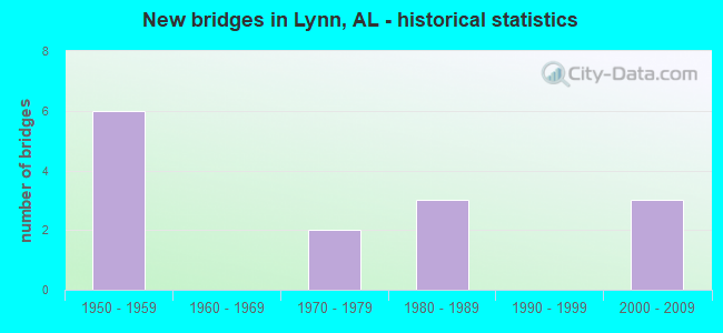
- New bridges - historical statistics
- 61950-1959
- 21970-1979
- 31980-1989
- 32000-2009

- Reconstructed bridges - Historical Statistics
- 11980-1989
- 01990-1999
- 12000-2009


- Bridge Condition - Deck
- 20.0%Excellent
- 60.0%Satisfactory
- 20.0%Fair

- Bridge Condition - Superstructure
- 20.0%Excellent
- 20.0%Good
- 60.0%Satisfactory

- Bridge Condition - Substructure
- 20.0%Excellent
- 60.0%Satisfactory
- 20.0%Fair

- Bridge Condition - Channel
- 7.1%Excellent
- 14.3%Very good
- 7.1%Good
- 35.7%Satisfactory
- 35.7%Fair

- Bridge Condition - Culverts
- 22.2%Very good
- 66.7%Satisfactory
- 11.1%Fair
Find on map >> Show street view
Structure Number: 4535, Location: 3 MI E JCT SR 13 (Lat: 34.029883, Lng: -87.556392), Route carried "on" structure: County highway 1, Year Built: 1953, Status: Open, Structure Length: 1.83m (6.00ft), Average Daily Traffic: 200 (year 1991), Truck Traffic: 5%, Average Future Daily Traffic: 300 (year 2032), Design Load: H 15, Features Intersected: BLACKWATER CREEK
Minimum Vertical Clearance: 30+ m (98+ ft), Kilometerpoint: 0.010, Lanes on structure: 2, Owner: County Highway Agency, Approaching Roadway Width: 5.5m (18.0ft), Material/Design: Concrete, Design/Construction: Culvert, Number Of Spans In Main Unit: 5, Length of Maximum Span: 3.7m (12.1ft), Curb-To-Curb Width: 12.2m (40.0ft), Out-to-Out Width: 12.2m (40.0ft)
Condition: Channel: Fair, Culverts: Satisfactory, Operating Rating: 41.6 metric tons, Method Used To Determine Operating Rating: Load Factor (LF), Inventory Rating: 24.9 metric tons, Method Used To Determine Inventory Rating: Load Factor (LF), Structural Evaluation: Equal to present minimum criteria, Deck Geometry: Superior to present desirable criteria, Waterway Adequacy: Somewhat better than minimum adequacy, Approach Roadway Alignment: Better than present minimum criteria, Length Of Structure Improvement: 2.54m (8.33ft), Designated Inspection Frequency: Every 24 months, Inspection Date: August 2020, Bridge Improvement Cost: $588,000, Roadway Improvement Cost: $59,000, Total Project Cost: $647,000 ( Estimate for 2022)
Find on map >> Show street view
Structure Number: 4856, Location: 2 MI E JCT SR 5 (Lat: 34.052797, Lng: -87.532075), Route carried "on" structure: County highway 25, Year Built: 1954, Status: Posted for load, Structure Length: 5.18m (16.99ft), Average Daily Traffic: 750 (year 1991), Truck Traffic: 1%, Average Future Daily Traffic: 1,000 (year 2032), Design Load: H 15, Features Intersected: SPLUNGE CREEK
Minimum Vertical Clearance: 7.56m (24.80ft), Kilometerpoint: 0.010, Lanes on structure: 2, Owner: County Highway Agency, Approaching Roadway Width: 5.5m (18.0ft), Skew: 1 degrees, Material/Design: Concrete, Design/Construction: Tee Beam, Number Of Spans In Main Unit: 5, Length of Maximum Span: 10.4m (34.1ft), Curb or Sidewalk Widths: Left: 0.2m (0.7ft), Right: 0.2m (0.7ft), Curb-To-Curb Width: 6.7m (22.0ft), Out-to-Out Width: 7.3m (24.0ft)
Condition: Deck: Satisfactory, Superstructure: Satisfactory, Substructure: Satisfactory, Channel: Fair, Operating Rating: 36.9 metric tons, Method Used To Determine Operating Rating: Load Factor (LF), Inventory Rating: 22.1 metric tons, Method Used To Determine Inventory Rating: Load Factor (LF), Structural Evaluation: Somewhat better than minimum adequacy, Deck Geometry: Meets minimum limits, Waterway Adequacy: Equal to present minimum criteria, Approach Roadway Alignment: Equal to present minimum criteria, Bridge Posting: Required (Relationship of Operating Rating to Maximum Legal Load: 0.1 - 9.9% below), Length Of Structure Improvement: 6.20m (20.34ft), Designated Inspection Frequency: Every 24 months, Other Special Inspection Frequency: Every 12 months, Inspection Date: Febuary 2022, Other Special Inspection Date: Febuary 2022, Bridge Improvement Cost: $1,021,000, Roadway Improvement Cost: $102,000, Total Project Cost: $1,123,000 ( Estimate for 2022), Deck Structure Type: Concrete Cast-file-Place
Find on map >> Show street view
Structure Number: 6071, Location: 1.5 MI W JCT CO RD 305 (Lat: 34.880542, Lng: -86.472283), Route carried "on" structure: County highway 453, Year Built: 1957, Status: Posted for load, Structure Length: 9.05m (29.69ft), Average Daily Traffic: 1,513 (year 2002), Truck Traffic: 1%, Average Future Daily Traffic: 1,815 (year 2041), Design Load: H 15, Features Intersected: MOUNTAIN FORK CREEK, Facility Carried by Structure: O. PATTERSON RD
Minimum Vertical Clearance: 30+ m (98+ ft), Kilometerpoint: 0.010, Lanes on structure: 2, Owner: County Highway Agency, Approaching Roadway Width: 9.8m (32.2ft), Material/Design: Concrete continuous, Design/Construction: Tee Beam, Number Of Spans In Main Unit: 3, Number Of Approach Spans: 4, Length of Maximum Span: 18.3m (60.0ft), Curb-To-Curb Width: 6.6m (21.7ft), Out-to-Out Width: 7.1m (23.3ft)
Condition: Deck: Satisfactory, Superstructure: Satisfactory, Substructure: Fair, Channel: Satisfactory, Operating Rating: 31.8 metric tons, Method Used To Determine Operating Rating: Load Factor (LF), Inventory Rating: 19.1 metric tons, Method Used To Determine Inventory Rating: Load Factor (LF), Structural Evaluation: Somewhat better than minimum adequacy, Deck Geometry: High priority of replacement, Waterway Adequacy: Somewhat better than minimum adequacy, Approach Roadway Alignment: Meets minimum limits, Bridge Posting: Required (Relationship of Operating Rating to Maximum Legal Load: 10.0 - 19.9% below), Length Of Structure Improvement: 10.02m (32.87ft), Designated Inspection Frequency: Every 24 months, Underwater Inspection Frequency: Every 48 months, Other Special Inspection Frequency: Every 12 months, Inspection Date: Febuary 2021, Underwater Inspection Date: July 2020, Other Special Inspection Date: Febuary 2022, Bridge Improvement Cost: $1,580,000, Roadway Improvement Cost: $158,000, Total Project Cost: $1,738,000 ( Estimate for 2022), Deck Structure Type: Concrete Cast-file-Place
Find on map >> Show street view
Structure Number: 6339, Location: 1 MI E JCT AL 5 (Lat: 34.090083, Lng: -87.578528), Route carried "on" structure: US 278, Year Built: 1958, Status: Open, Structure Length: 1.55m (5.09ft), Average Daily Traffic: 3,670 (year 2013), Truck Traffic: 19%, Average Future Daily Traffic: 4,668 (year 2041), Design Load: HS 20, Features Intersected: Splunge Creek, Facility Carried by Structure: AL-74
Minimum Vertical Clearance: 30+ m (98+ ft), Kilometerpoint: 47.846, Lanes on structure: 2, Base Highway Network: Yes, Owner: State Highway Agency, Approaching Roadway Width: 7.2m (23.6ft), Material/Design: Concrete, Design/Construction: Culvert, Number Of Spans In Main Unit: 4, Length of Maximum Span: 3.7m (12.1ft)
Condition: Channel: Satisfactory, Culverts: Satisfactory, Operating Rating: 88.9 metric tons, Method Used To Determine Operating Rating: Load Factor (LF), Inventory Rating: 88.9 metric tons, Method Used To Determine Inventory Rating: Load Factor (LF), Structural Evaluation: Equal to present minimum criteria, Waterway Adequacy: Better than present minimum criteria, Approach Roadway Alignment: Better than present minimum criteria, Length Of Structure Improvement: 2.23m (7.32ft), Designated Inspection Frequency: Every 24 months, Inspection Date: January 2022, Bridge Improvement Cost: $1,806,000, Roadway Improvement Cost: $181,000, Total Project Cost: $1,987,000 ( Estimate for 2022)
Find on map >> Show street view
Structure Number: 634, Location: 2.5 MI E JCT SR 5 (Lat: 34.108694, Lng: -87.564444), Route carried "on" structure: US 278, Year Built: 1958, Status: Open, Structure Length: 0.82m (2.69ft), Average Daily Traffic: 3,670 (year 2013), Truck Traffic: 19%, Average Future Daily Traffic: 4,668 (year 2041), Design Load: HS 20, Features Intersected: Meadow Creek, Facility Carried by Structure: AL-74
Minimum Vertical Clearance: 30+ m (98+ ft), Kilometerpoint: 50.356, Lanes on structure: 2, Base Highway Network: Yes, Owner: State Highway Agency, Approaching Roadway Width: 7.3m (24.0ft), Material/Design: Concrete, Design/Construction: Culvert, Number Of Spans In Main Unit: 2, Length of Maximum Span: 3.7m (12.1ft)
Condition: Channel: Satisfactory, Culverts: Satisfactory, Operating Rating: 88.9 metric tons, Method Used To Determine Operating Rating: Load Factor (LF), Inventory Rating: 88.9 metric tons, Method Used To Determine Inventory Rating: Load Factor (LF), Structural Evaluation: Equal to present minimum criteria, Waterway Adequacy: Better than present minimum criteria, Approach Roadway Alignment: Equal to present desirable criteria, Length Of Structure Improvement: 1.48m (4.86ft), Designated Inspection Frequency: Every 24 months, Inspection Date: January 2022, Bridge Improvement Cost: $1,417,000, Roadway Improvement Cost: $142,000, Total Project Cost: $1,559,000 ( Estimate for 2022)
Find on map >> Show street view
Structure Number: 6341, Location: 4.9 MI E JCT SR 5 (Lat: 34.129472, Lng: -87.533389), Route carried "on" structure: US 278, Year Built: 1958, Status: Open, Structure Length: 1.55m (5.09ft), Average Daily Traffic: 2,080 (year 2013), Truck Traffic: 19%, Average Future Daily Traffic: 2,646 (year 2041), Design Load: HS 20, Features Intersected: Little Creek, Facility Carried by Structure: AL-74
Minimum Vertical Clearance: 30+ m (98+ ft), Kilometerpoint: 54.283, Lanes on structure: 2, Base Highway Network: Yes, Owner: State Highway Agency, Approaching Roadway Width: 8.0m (26.2ft), Material/Design: Concrete, Design/Construction: Culvert, Number Of Spans In Main Unit: 4, Length of Maximum Span: 3.7m (12.1ft)
Condition: Channel: Fair, Culverts: Satisfactory, Operating Rating: 88.9 metric tons, Method Used To Determine Operating Rating: Load Factor (LF), Inventory Rating: 88.9 metric tons, Method Used To Determine Inventory Rating: Load Factor (LF), Structural Evaluation: Equal to present minimum criteria, Waterway Adequacy: Somewhat better than minimum adequacy, Approach Roadway Alignment: Equal to present desirable criteria, Length Of Structure Improvement: 2.23m (7.32ft), Designated Inspection Frequency: Every 24 months, Inspection Date: January 2022, Bridge Improvement Cost: $929,000, Roadway Improvement Cost: $93,000, Total Project Cost: $1,022,000 ( Estimate for 2022)
Find on map >> Show street view
Structure Number: 10246, Location: 1 MILL N DOGTOWN (Lat: 33.971306, Lng: -87.572028), Route carried "on" structure: County highway , Year Built: 1970, Year Reconstructed: 1993, Status: Posted for load, Structure Length: 2.70m (8.86ft), Average Daily Traffic: 160 (year 1991), Truck Traffic: 5%, Average Future Daily Traffic: 224 (year 2032), Design Load: H 15, Features Intersected: MILL CREEK, Facility Carried by Structure: BONNER HOLLOW RD
Minimum Vertical Clearance: 30+ m (98+ ft), Kilometerpoint: 0.010, Lanes on structure: 2, Owner: County Highway Agency, Approaching Roadway Width: 4.6m (15.1ft), Material/Design: Steel, Design/Construction: Stringer/Multi-beam, Number Of Spans In Main Unit: 3, Length of Maximum Span: 9.4m (30.8ft), Curb-To-Curb Width: 4.6m (15.1ft), Out-to-Out Width: 4.6m (15.1ft)
Condition: Deck: Fair, Superstructure: Good, Substructure: Satisfactory, Channel: Satisfactory, Operating Rating: 36.6 metric tons, Method Used To Determine Operating Rating: Allowable Stress (AS), Inventory Rating: 24.7 metric tons, Method Used To Determine Inventory Rating: Allowable Stress (AS), Structural Evaluation: Equal to present minimum criteria, Waterway Adequacy: Better than present minimum criteria, Approach Roadway Alignment: Better than present minimum criteria, Bridge Posting: Required (Relationship of Operating Rating to Maximum Legal Load: 20.0 - 29.9% below), Length Of Structure Improvement: 3.61m (11.84ft), Designated Inspection Frequency: Every 24 months, Other Special Inspection Frequency: Every 12 months, Inspection Date: March 2020, Other Special Inspection Date: March 2021, Bridge Improvement Cost: $372,000, Roadway Improvement Cost: $37,000, Total Project Cost: $409,000 ( Estimate for 2022), Deck Structure Type: Corrugated Steel, Wearing Surface/Protective System: Wearing Surface: Gravel
Find on map >> Show street view
Structure Number: 13327, Location: 1MI N JCT CO RD 34 (Lat: 34.086206, Lng: -87.567133), Route carried "on" structure: County highway 49, Year Built: 1984, Status: Open, Structure Length: 1.10m (3.61ft), Average Daily Traffic: 100 (year 1991), Average Future Daily Traffic: 250 (year 2032), Design Load: H 20, Features Intersected: SPLUNGE CREEK
Minimum Vertical Clearance: 7.56m (24.80ft), Kilometerpoint: 0.010, Lanes on structure: 2, Owner: County Highway Agency, Approaching Roadway Width: 8.5m (27.9ft), Material/Design: Concrete, Design/Construction: Culvert, Number Of Spans In Main Unit: 3, Length of Maximum Span: 3.7m (12.1ft)
Condition: Channel: Satisfactory, Culverts: Fair, Operating Rating: 88.9 metric tons, Method Used To Determine Operating Rating: Load Factor (LF), Inventory Rating: 71.2 metric tons, Method Used To Determine Inventory Rating: Load Factor (LF), Structural Evaluation: Somewhat better than minimum adequacy, Waterway Adequacy: Equal to present minimum criteria, Approach Roadway Alignment: Somewhat better than minimum adequacy, Length Of Structure Improvement: 1.77m (5.81ft), Designated Inspection Frequency: Every 24 months, Inspection Date: August 2020, Bridge Improvement Cost: $615,000, Roadway Improvement Cost: $62,000, Total Project Cost: $677,000 ( Estimate for 2022)
Find on map >> Show street view
Structure Number: 14665, Location: 1 MI W JCT CO RD 59 (Lat: 34.022367, Lng: -87.523225), Route carried "on" structure: County highway 350, Year Built: 1988, Status: Open, Structure Length: 0.98m (3.22ft), Average Daily Traffic: 10 (year 1999), Average Future Daily Traffic: 30 (year 2032), Design Load: HS 20, Features Intersected: BLACKWATER CREEK, Facility Carried by Structure: UNPAVED CO RD
Minimum Vertical Clearance: 7.56m (24.80ft), Kilometerpoint: 0.010, Lanes on structure: 1, Owner: County Highway Agency, Approaching Roadway Width: 4.9m (16.1ft), Material/Design: Steel, Design/Construction: Stringer/Multi-beam, Number Of Spans In Main Unit: 1, Length of Maximum Span: 9.8m (32.2ft), Curb-To-Curb Width: 3.4m (11.2ft), Out-to-Out Width: 3.7m (12.1ft)
Condition: Deck: Satisfactory, Superstructure: Satisfactory, Substructure: Satisfactory, Channel: Fair, Operating Rating: 61.1 metric tons, Method Used To Determine Operating Rating: Allowable Stress (AS), Inventory Rating: 43.5 metric tons, Method Used To Determine Inventory Rating: Allowable Stress (AS), Structural Evaluation: Equal to present minimum criteria, Deck Geometry: High priority of corrective action, Waterway Adequacy: Somewhat better than minimum adequacy, Approach Roadway Alignment: Meets minimum limits, Length Of Structure Improvement: 1.65m (5.41ft), Designated Inspection Frequency: Every 24 months, Inspection Date: January 2022, Bridge Improvement Cost: $136,000, Roadway Improvement Cost: $14,000, Total Project Cost: $150,000 ( Estimate for 2022), Deck Structure Type: Wood or Timber, Wearing Surface/Protective System: Wearing Surface: Wood or Timber
Find on map >> Show street view
Structure Number: 14875, Location: 1 MI E CO RD 37 JCT (Lat: 34.083358, Lng: -87.505289), Route carried "on" structure: County highway 25, Year Built: 1989, Status: Open, Structure Length: 1.01m (3.31ft), Average Daily Traffic: 750 (year 1991), Truck Traffic: 1%, Average Future Daily Traffic: 1,000 (year 2032), Design Load: HS 20, Features Intersected: BROWNS CREEK
Minimum Vertical Clearance: 7.56m (24.80ft), Kilometerpoint: 0.000, Lanes on structure: 2, Owner: County Highway Agency, Approaching Roadway Width: 8.5m (27.9ft), Material/Design: Concrete, Design/Construction: Culvert, Number Of Spans In Main Unit: 3, Length of Maximum Span: 3.0m (9.8ft)
Condition: Channel: Fair, Culverts: Satisfactory, Operating Rating: 49.4 metric tons, Method Used To Determine Operating Rating: Load Factor (LF), Inventory Rating: 29.7 metric tons, Method Used To Determine Inventory Rating: Load Factor (LF), Structural Evaluation: Equal to present minimum criteria, Waterway Adequacy: Equal to present minimum criteria, Approach Roadway Alignment: Better than present minimum criteria, Length Of Structure Improvement: 1.68m (5.51ft), Designated Inspection Frequency: Every 24 months, Inspection Date: April 2021, Bridge Improvement Cost: $582,000, Roadway Improvement Cost: $58,000, Total Project Cost: $640,000 ( Estimate for 2022)
Find on map >> Show street view
Structure Number: 1847, Location: 2 MI N JCT CORD 25 (Lat: 34.074289, Lng: -87.544028), Route carried "on" structure: County highway 17, Year Built: 2003, Status: Open, Structure Length: 4.57m (14.99ft), Average Daily Traffic: 330 (year 2002), Average Future Daily Traffic: 490 (year 2032), Design Load: HS 20, Features Intersected: SPLUNGE CREEK
Minimum Vertical Clearance: 30+ m (98+ ft), Kilometerpoint: 0.016, Lanes on structure: 2, Owner: County Highway Agency, Approaching Roadway Width: 6.1m (20.0ft), Material/Design: Prestressed concrete, Design/Construction: Stringer/Multi-beam, Number Of Spans In Main Unit: 3, Length of Maximum Span: 15.2m (49.9ft), Curb or Sidewalk Widths: Left: 0.3m (1.0ft), Right: 0.3m (1.0ft), Curb-To-Curb Width: 8.5m (27.9ft), Out-to-Out Width: 9.4m (30.8ft)
Condition: Deck: Excellent, Superstructure: Excellent, Substructure: Excellent, Channel: Excellent, Operating Rating: 65.7 metric tons, Method Used To Determine Operating Rating: Load Factor (LF), Inventory Rating: 37.7 metric tons, Method Used To Determine Inventory Rating: Load Factor (LF), Structural Evaluation: Superior to present desirable criteria, Deck Geometry: High priority of corrective action, Waterway Adequacy: Superior to present desirable criteria, Approach Roadway Alignment: Equal to present desirable criteria, Length Of Structure Improvement: 5.57m (18.27ft), Designated Inspection Frequency: Every 24 months, Underwater Inspection Frequency: Every 48 months, Inspection Date: Febuary 2022, Underwater Inspection Date: April 2020, Bridge Improvement Cost: $1,145,000, Roadway Improvement Cost: $115,000, Total Project Cost: $1,260,000 ( Estimate for 2022), Deck Structure Type: Concrete Cast-file-Place
Find on map >> Show street view
Structure Number: 18822, Location: CORD.360 (Lat: 34.079456, Lng: -87.544894), Route carried "on" structure: County highway 360, Year Built: 2004, Status: Open, Structure Length: 1.92m (6.30ft), Average Daily Traffic: 45 (year 2004), Average Future Daily Traffic: 70 (year 2032), Features Intersected: MEADOW CREEK
Minimum Vertical Clearance: 30+ m (98+ ft), Kilometerpoint: 0.016, Lanes on structure: 2, Owner: County Highway Agency, Approaching Roadway Width: 7.9m (25.9ft), Skew: 1 degrees, Material/Design: Concrete, Design/Construction: Culvert, Number Of Spans In Main Unit: 4, Length of Maximum Span: 4.3m (14.1ft), Curb or Sidewalk Widths: Left: 0.2m (0.7ft), Right: 0.2m (0.7ft), Curb-To-Curb Width: 7.9m (25.9ft), Out-to-Out Width: 18.8m (61.7ft)
Condition: Channel: Very good, Culverts: Very good, Operating Rating: 86.5 metric tons, Method Used To Determine Operating Rating: Load Factor (LF), Inventory Rating: 51.9 metric tons, Method Used To Determine Inventory Rating: Load Factor (LF), Structural Evaluation: Equal to present desirable criteria, Deck Geometry: High priority of corrective action, Waterway Adequacy: Superior to present desirable criteria, Approach Roadway Alignment: Equal to present minimum criteria, Length Of Structure Improvement: 2.65m (8.69ft), Designated Inspection Frequency: Every 24 months, Inspection Date: May 2020, Bridge Improvement Cost: $965,000, Roadway Improvement Cost: $97,000, Total Project Cost: $1,062,000 ( Estimate for 2022), Deck Structure Type: Concrete Cast-file-Place, Wearing Surface/Protective System: Wearing Surface: Other
Find on map >> Show street view
Structure Number: 18825, Location: ????????????????????????? (Lat: 34.045492, Lng: -87.514250), Route carried "on" structure: County highway 339, Year Built: 2004, Status: Open, Structure Length: 1.98m (6.50ft), Average Daily Traffic: 25 (year 2004), Average Future Daily Traffic: 75 (year 2032), Features Intersected: SPLUNGE CREEK
Minimum Vertical Clearance: 30+ m (98+ ft), Kilometerpoint: 0.016, Lanes on structure: 2, Owner: County Highway Agency, Approaching Roadway Width: 7.3m (24.0ft), Skew: 3 degrees, Material/Design: Concrete, Design/Construction: Culvert, Number Of Spans In Main Unit: 2, Length of Maximum Span: 4.3m (14.1ft), Curb or Sidewalk Widths: Left: 0.2m (0.7ft), Right: 0.2m (0.7ft), Curb-To-Curb Width: 7.9m (25.9ft), Out-to-Out Width: 19.8m (65.0ft)
Condition: Channel: Very good, Culverts: Very good, Operating Rating: 79.1 metric tons, Method Used To Determine Operating Rating: Load Factor (LF), Inventory Rating: 47.4 metric tons, Method Used To Determine Inventory Rating: Load Factor (LF), Structural Evaluation: Equal to present desirable criteria, Deck Geometry: High priority of corrective action, Waterway Adequacy: Superior to present desirable criteria, Approach Roadway Alignment: Equal to present desirable criteria, Length Of Structure Improvement: 2.73m (8.96ft), Designated Inspection Frequency: Every 24 months, Inspection Date: January 2022, Bridge Improvement Cost: $1,023,000, Roadway Improvement Cost: $102,000, Total Project Cost: $1,125,000 ( Estimate for 2022), Deck Structure Type: Concrete Cast-file-Place
Find on map >> Show street view
Structure Number: DAPAMCANN0000H5, Location: NEAR BLD 513 & ROOSEVELT (Lat: 33.641219, Lng: -85.918869), Route carried "on" structure: Other road , Year Built: 1978, Year Reconstructed: 2009, Status: Open, Structure Length: 0.85m (2.79ft), Average Daily Traffic: 540 (year 2015), Truck Traffic: 20%, Average Future Daily Traffic: 560 (year 2043), Features Intersected: STORM WATER RUN OFF, Facility Carried by Structure: 3RD AVENUE
Minimum Vertical Clearance: 30+ m (98+ ft), Kilometerpoint: 0.000, Lanes on structure: 2, Owner: Army, Approaching Roadway Width: 8.5m (27.9ft), Material/Design: Concrete, Design/Construction: Culvert, Number Of Spans In Main Unit: 4, Length of Maximum Span: 1.9m (6.2ft), Curb or Sidewalk Widths: Left: 1.2m (3.9ft), Right: 1.2m (3.9ft), Curb-To-Curb Width: 7.3m (24.0ft), Out-to-Out Width: 9.1m (29.9ft)
Condition: Channel: Good, Culverts: Satisfactory, Operating Rating: 42.4 metric tons, Method Used To Determine Operating Rating: Field evaluation and documented engineering judgment, Inventory Rating: 32.7 metric tons, Method Used To Determine Inventory Rating: Field evaluation and documented engineering judgment, Structural Evaluation: Equal to present minimum criteria, Deck Geometry: Meets minimum limits, Waterway Adequacy: Superior to present desirable criteria, Approach Roadway Alignment: Equal to present desirable criteria, Length Of Structure Improvement: 1.51m (4.95ft), Designated Inspection Frequency: Every 24 months, Inspection Date: November 2021, Bridge Improvement Cost: $10,000, Roadway Improvement Cost: $1,000, Total Project Cost: $11,000 ( Estimate for 2021)