Bridge Statistics for Luzerne, Pennsylvania (PA)
Condition, Traffic, Stress, Structural Evaluation, Project Costs
- National Bridge Inventory (NBI) Statistics
- 12Number of bridges
- 141ft / 42.5mTotal length
- $4,560,000Total costs
- 185,420Total average daily traffic
- 8,785Total average daily truck traffic
- National Bridge Inventory (NBI) Registered Bridges for Luzerne
- No street view available for this location
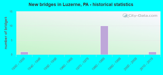
- New bridges - historical statistics
- 11930-1939
- 101980-1989
- 12010-2019


- Bridge Condition - Deck
- 25.0%Very good
- 37.5%Good
- 12.5%Satisfactory
- 12.5%Fair
- 12.5%Poor

- Bridge Condition - Superstructure
- 12.5%Excellent
- 37.5%Good
- 25.0%Satisfactory
- 12.5%Fair
- 12.5%Poor

- Bridge Condition - Substructure
- 12.5%Very good
- 12.5%Good
- 25.0%Satisfactory
- 37.5%Fair
- 12.5%Poor

- Bridge Condition - Channel
- 25.0%Good
- 25.0%Fair
- 50.0%Poor
Find on map >> Show street view
Structure Number: 23885, Location: LUZERNE BO .2 M N SR 1015 (Lat: 41.277769, Lng: -75.888617), Route carried "on" structure: State highway 309, Year Built: 1980, Year Reconstructed: 2016, Status: Open, Structure Length: 4.82m (15.81ft), Average Daily Traffic: 40,149 (year 2020), Truck Traffic: 5%, Average Future Daily Traffic: 55,586 (year 2032), Design Load: HS 20, Features Intersected: LUZ CO RAIL AUTHORITY
Minimum Vertical Clearance: 30+ m (98+ ft), Kilometerpoint: 44.722, Lanes on structure: 3, Base Highway Network: Yes, Owner: State Highway Agency, Approaching Roadway Width: 30.5m (100.1ft), Skew: 31 degrees, Material/Design: Prestressed concrete, Design/Construction: Box Beam or Girders - Single/Spread, Number Of Spans In Main Unit: 3, Length of Maximum Span: 16.2m (53.1ft), Curb or Sidewalk Widths: Left: 0.2m (0.7ft), Right: 0.2m (0.7ft), Curb-To-Curb Width: 29.9m (98.1ft), Out-to-Out Width: 32.3m (106.0ft)
Condition: Deck: Very good, Superstructure: Good, Substructure: Satisfactory, Operating Rating: 66.2 metric tons, Method Used To Determine Operating Rating: Load Factor (LF), Inventory Rating: 31.8 metric tons, Method Used To Determine Inventory Rating: Load Factor (LF), Structural Evaluation: Equal to present minimum criteria, Deck Geometry: Superior to present desirable criteria, Underclear: High priority of corrective action, Approach Roadway Alignment: Equal to present desirable criteria, Length Of Structure Improvement: 4.80m (15.75ft), Designated Inspection Frequency: Every 24 months, Inspection Date: September 2020, Bridge Improvement Cost: $42,000, Roadway Improvement Cost: $123,000, Total Project Cost: $564,000, Deck Structure Type: Concrete Cast-file-Place, Wearing Surface/Protective System: Wearing Surface: Epoxy Overlay, Deck Protection: Epoxy Coated Reinforcing
Find on map >> Show street view
Structure Number: 23886, Location: LUZ BORO OVER VAUGHN ST (Lat: 41.278331, Lng: -75.890000), Route carried "on" structure: State highway 309, Year Built: 1980, Year Reconstructed: 2016, Status: Open, Structure Length: 6.04m (19.82ft), Average Daily Traffic: 40,149 (year 2020), Truck Traffic: 5%, Average Future Daily Traffic: 55,586 (year 2032), Design Load: HS 20, Features Intersected: VAUGHN ST, ABANDONED RR
Minimum Vertical Clearance: 30+ m (98+ ft), Kilometerpoint: 45.398, Lanes on structure: 3, Lanes under structure: 2, Base Highway Network: Yes, Owner: State Highway Agency, Approaching Roadway Width: 30.5m (100.1ft), Skew: 32 degrees, Material/Design: Prestressed concrete, Design/Construction: Stringer/Multi-beam, Number Of Spans In Main Unit: 3, Length of Maximum Span: 27.4m (89.9ft), Curb or Sidewalk Widths: Left: 0.2m (0.7ft), Right: 0.2m (0.7ft), Curb-To-Curb Width: 30.3m (99.4ft), Out-to-Out Width: 32.3m (106.0ft)
Condition: Deck: Good, Superstructure: Good, Substructure: Good, Operating Rating: 68.0 metric tons, Method Used To Determine Operating Rating: Load Factor (LF), Inventory Rating: 30.8 metric tons, Method Used To Determine Inventory Rating: Load Factor (LF), Structural Evaluation: Better than present minimum criteria, Deck Geometry: Superior to present desirable criteria, Underclear: Superior to present desirable criteria, Approach Roadway Alignment: Equal to present desirable criteria, Length Of Structure Improvement: 6.00m (19.69ft), Designated Inspection Frequency: Every 24 months, Inspection Date: September 2020, Bridge Improvement Cost: $61,000, Roadway Improvement Cost: $181,000, Total Project Cost: $828,000, Deck Structure Type: Concrete Cast-file-Place, Wearing Surface/Protective System: Wearing Surface: Latex Concrete, Deck Protection: Epoxy Coated Reinforcing
Find on map >> Show street view
Structure Number: 23887, Location: LUZERNE BORO OVER SR 1013 (Lat: 41.279856, Lng: -75.894817), Route carried "on" structure: State highway 309, Year Built: 1980, Year Reconstructed: 2018, Status: Open, Structure Length: 15.76m (51.71ft), Average Daily Traffic: 34,500 (year 2022), Truck Traffic: 5%, Average Future Daily Traffic: 45,697 (year 2032), Design Load: HS 20, Features Intersected: SR 1013 UNION STREET
Minimum Vertical Clearance: 30+ m (98+ ft), Kilometerpoint: 45.398, Lanes on structure: 2, Lanes under structure: 3, Base Highway Network: Yes, Owner: State Highway Agency, Approaching Roadway Width: 24.1m (79.1ft), Skew: 35 degrees, Material/Design: Steel continuous, Design/Construction: Stringer/Multi-beam, Number Of Spans In Main Unit: 6, Length of Maximum Span: 32.6m (107.0ft), Curb or Sidewalk Widths: Left: 0.2m (0.7ft), Right: 0.2m (0.7ft), Curb-To-Curb Width: 24.2m (79.4ft), Out-to-Out Width: 26.2m (86.0ft)
Condition: Deck: Good, Superstructure: Satisfactory, Substructure: Satisfactory, Operating Rating: 89.8 metric tons, Method Used To Determine Operating Rating: Load Factor (LF), Inventory Rating: 53.5 metric tons, Method Used To Determine Inventory Rating: Load Factor (LF), Structural Evaluation: Equal to present minimum criteria, Deck Geometry: Superior to present desirable criteria, Underclear: Meets minimum limits, Approach Roadway Alignment: Equal to present desirable criteria, Length Of Structure Improvement: 15.80m (51.84ft), Designated Inspection Frequency: Every 24 months, Inspection Date: September 2020, Bridge Improvement Cost: $130,000, Roadway Improvement Cost: $382,000, Total Project Cost: $1,752,000, Deck Structure Type: Concrete Cast-file-Place, Wearing Surface/Protective System: Wearing Surface: Latex Concrete
Find on map >> Show street view
Structure Number: 23891, Location: LUZERNE BORO OVER SR 8039 (Lat: 41.287556, Lng: -75.904178), Route carried "on" structure: State highway 309, Year Built: 1980, Status: Open, Structure Length: 5.33m (17.49ft), Average Daily Traffic: 34,500 (year 2022), Truck Traffic: 5%, Average Future Daily Traffic: 45,697 (year 2032), Design Load: HS 20, Features Intersected: RAMP A; SR 8039
Minimum Vertical Clearance: 30+ m (98+ ft), Kilometerpoint: 47.081, Lanes on structure: 4, Lanes under structure: 1, Base Highway Network: Yes, Owner: State Highway Agency, Approaching Roadway Width: 24.1m (79.1ft), Skew: 34 degrees, Material/Design: Steel, Design/Construction: Stringer/Multi-beam, Number Of Spans In Main Unit: 1, Number Of Approach Spans: 2, Length of Maximum Span: 26.2m (86.0ft), Curb or Sidewalk Widths: Left: 0.2m (0.7ft), Right: 0.2m (0.7ft), Curb-To-Curb Width: 24.0m (78.7ft), Out-to-Out Width: 25.9m (85.0ft)
Condition: Deck: Poor, Superstructure: Poor, Substructure: Fair, Operating Rating: 73.5 metric tons, Method Used To Determine Operating Rating: Load Factor (LF), Inventory Rating: 43.5 metric tons, Method Used To Determine Inventory Rating: Load Factor (LF), Structural Evaluation: Meets minimum limits, Deck Geometry: Superior to present desirable criteria, Underclear: Meets minimum limits, Approach Roadway Alignment: Equal to present desirable criteria, Length Of Structure Improvement: 5.30m (17.39ft), Designated Inspection Frequency: Every 24 months, Other Special Inspection Frequency: Every 6 months, Inspection Date: November 2020, Other Special Inspection Date: May 2021, Bridge Improvement Cost: $18,000, Roadway Improvement Cost: $100,000, Total Project Cost: $238,000, Deck Structure Type: Concrete Cast-file-Place, Wearing Surface/Protective System: Wearing Surface: Monolithic Concrete, Deck Protection: Epoxy Coated Reinforcing
Find on map >> Show street view
Structure Number: 23966, Location: LUZERNE BORO JCT SR 1013 (Lat: 41.284756, Lng: -75.898697), Route carried "on" structure: State highway , Year Built: 1989, Status: Open, Structure Length: 2.68m (8.79ft), Average Daily Traffic: 3,494 (year 2022), Truck Traffic: 2%, Average Future Daily Traffic: 4,640 (year 2032), Design Load: HS 25 or greater, Features Intersected: TOBY CREEK, Facility Carried by Structure: SR 1008
Minimum Vertical Clearance: 30+ m (98+ ft), Kilometerpoint: 0.000, Lanes on structure: 3, Owner: State Highway Agency, Approaching Roadway Width: 12.2m (40.0ft), Skew: 4 degrees, Material/Design: Prestressed concrete, Design/Construction: Box Beam or Girders - Multiple, Number Of Spans In Main Unit: 2, Length of Maximum Span: 12.8m (42.0ft), Curb or Sidewalk Widths: Left: 0.2m (0.7ft), Right: 1.7m (5.6ft), Curb-To-Curb Width: 12.2m (40.0ft), Out-to-Out Width: 14.8m (48.6ft)
Condition: Deck: Satisfactory, Superstructure: Satisfactory, Substructure: Fair, Channel: Poor, Operating Rating: 97.1 metric tons, Method Used To Determine Operating Rating: Load Factor (LF), Inventory Rating: 58.1 metric tons, Method Used To Determine Inventory Rating: Load Factor (LF), Structural Evaluation: Somewhat better than minimum adequacy, Deck Geometry: Meets minimum limits, Waterway Adequacy: Equal to present desirable criteria, Approach Roadway Alignment: Equal to present minimum criteria, Length Of Structure Improvement: 3.40m (11.15ft), Designated Inspection Frequency: Every 24 months, Inspection Date: September 2020, Deck Structure Type: Concrete Cast-file-Place, Wearing Surface/Protective System: Wearing Surface: Monolithic Concrete, Deck Protection: Epoxy Coated Reinforcing
Find on map >> Show street view
Structure Number: 23978, Location: LUZERNE BO .1 M N TR 309 (Lat: 41.281422, Lng: -75.895511), Route carried "on" structure: State highway , Year Built: 1939, Status: Open, Structure Length: 4.79m (15.72ft), Average Daily Traffic: 10,092 (year 2022), Truck Traffic: 4%, Average Future Daily Traffic: 13,872 (year 2032), Design Load: H 20, Features Intersected: TOBYS CREEK, Facility Carried by Structure: SR 1013
Minimum Vertical Clearance: 30+ m (98+ ft), Kilometerpoint: 0.710, Lanes on structure: 3, Owner: State Highway Agency, Approaching Roadway Width: 12.2m (40.0ft), Skew: 6 degrees, Material/Design: Concrete, Design/Construction: Tee Beam, Number Of Spans In Main Unit: 2, Length of Maximum Span: 23.2m (76.1ft), Curb or Sidewalk Widths: Left: 1.5m (4.9ft), Right: 1.5m (4.9ft), Curb-To-Curb Width: 12.2m (40.0ft), Out-to-Out Width: 15.8m (51.8ft)
Condition: Deck: Fair, Superstructure: Fair, Substructure: Poor, Channel: Poor, Operating Rating: 43.5 metric tons, Method Used To Determine Operating Rating: Load Factor (LF), Inventory Rating: 25.4 metric tons, Method Used To Determine Inventory Rating: Load Factor (LF), Structural Evaluation: Meets minimum limits, Deck Geometry: Meets minimum limits, Waterway Adequacy: Equal to present minimum criteria, Approach Roadway Alignment: Equal to present desirable criteria, Length Of Structure Improvement: 4.80m (15.75ft), Designated Inspection Frequency: Every 24 months, Other Special Inspection Frequency: Every 6 months, Inspection Date: September 2020, Other Special Inspection Date: September 2021, Bridge Improvement Cost: $85,000, Roadway Improvement Cost: $249,000, Total Project Cost: $1,143,000, Deck Structure Type: Concrete Cast-file-Place, Wearing Surface/Protective System: Wearing Surface: Bituminous
Find on map >> Show street view
Structure Number: 24471, Location: AT SR 1013 INTERSECT (Lat: 41.282081, Lng: -75.895533), Route carried "on" structure: City street , Year Built: 1980, Status: Open, Structure Length: 1.19m (3.90ft), Average Daily Traffic: 2,400 (year 2018), Truck Traffic: 2%, Average Future Daily Traffic: 3,200 (year 2036), Design Load: HS 20, Features Intersected: TOBY CREEK, Facility Carried by Structure: BUCKINGHAM ST
Minimum Vertical Clearance: 30+ m (98+ ft), Kilometerpoint: 0.000, Lanes on structure: 2, Owner: Town or Township Highway Agency, Approaching Roadway Width: 8.5m (27.9ft), Material/Design: Steel, Design/Construction: Stringer/Multi-beam, Number Of Spans In Main Unit: 1, Length of Maximum Span: 11.6m (38.1ft), Curb or Sidewalk Widths: Left: 1.5m (4.9ft), Right: 1.5m (4.9ft), Curb-To-Curb Width: 9.4m (30.8ft), Out-to-Out Width: 13.3m (43.6ft)
Condition: Deck: Good, Superstructure: Good, Substructure: Fair, Channel: Fair, Inventory Rating: 72.6 metric tons, Method Used To Determine Inventory Rating: Load Factor (LF), Structural Evaluation: Somewhat better than minimum adequacy, Deck Geometry: Meets minimum limits, Waterway Adequacy: Better than present minimum criteria, Approach Roadway Alignment: Equal to present desirable criteria, Length Of Structure Improvement: 1.20m (3.94ft), Designated Inspection Frequency: Every 24 months, Inspection Date: April 2020, Bridge Improvement Cost: $3,000, Roadway Improvement Cost: $7,000, Total Project Cost: $35,000, Deck Structure Type: Concrete Cast-file-Place, Wearing Surface/Protective System: Wearing Surface: Monolithic Concrete
Find on map >> Show street view
Structure Number: 47322, Location: LUZERNE BORO AT EVANS ST (Lat: 41.280797, Lng: -75.895433), Route carried "on" structure: State highway , Year Built: 2012, Status: Open, Structure Length: 1.92m (6.30ft), Average Daily Traffic: 6,129 (year 2022), Truck Traffic: 2%, Average Future Daily Traffic: 7,116 (year 2032), Design Load: HL 93, Features Intersected: TOBY CREEK, Facility Carried by Structure: SR 1054
Minimum Vertical Clearance: 30+ m (98+ ft), Kilometerpoint: 0.000, Lanes on structure: 3, Owner: State Highway Agency, Approaching Roadway Width: 12.2m (40.0ft), Material/Design: Prestressed concrete, Design/Construction: Box Beam or Girders - Single/Spread, Number Of Spans In Main Unit: 1, Length of Maximum Span: 18.6m (61.0ft), Curb or Sidewalk Widths: Left: 1.7m (5.6ft), Right: 0.2m (0.7ft), Curb-To-Curb Width: 12.2m (40.0ft), Out-to-Out Width: 14.8m (48.6ft)
Condition: Deck: Very good, Superstructure: Excellent, Substructure: Very good, Channel: Good, Operating Rating: 57.0 metric tons, Method Used To Determine Operating Rating: Assigned ratings based on Load and Resistance Factor Design (LRFD) reported by rating factor (RF) using HL93 loadings, Inventory Rating: 35.6 metric tons, Method Used To Determine Inventory Rating: Assigned ratings based on Load and Resistance Factor Design (LRFD) reported by rating factor (RF) using HL93 loadings, Structural Evaluation: Equal to present desirable criteria, Deck Geometry: Meets minimum limits, Waterway Adequacy: Equal to present desirable criteria, Approach Roadway Alignment: Better than present minimum criteria, Designated Inspection Frequency: Every 48 months, Inspection Date: September 2018, Deck Structure Type: Concrete Cast-file-Place, Wearing Surface/Protective System: Wearing Surface: Epoxy Overlay, Deck Protection: Epoxy Coated Reinforcing
Find on map >> Show street view
Structure Number: 23886, Location: LUZ BORO OVER VAUGHN ST (Lat: 41.278331, Lng: -75.890000), Route carried "under" structure: City street , Year Built: 1980, Structure Length: 0. m, Average Daily Traffic: 100 (year 2004), Truck Traffic: 10%, Features Intersected: VAUGHN ST, ABANDONED RR, Facility Carried by Structure: SR 0309 NB AND SB
Minimum Vertical Clearance: 6.81m (22.34ft), Kilometerpoint: 0.000, Lanes on structure: 3, Lanes under structure: 2, Material/Design: Prestressed concrete, Design/Construction: Stringer/Multi-beam, Length of Maximum Span: 27.4m (89.9ft)
Find on map >> Show street view
Structure Number: 23887, Location: LUZERNE BORO OVER SR 1013 (Lat: 41.279856, Lng: -75.894817), Route carried "under" structure: State highway , Year Built: 1980, Structure Length: 0. m, Average Daily Traffic: 5,046 (year 2022), Truck Traffic: 4%, Features Intersected: SR 1013 UNION STREET, Facility Carried by Structure: SR 0309 TR 309
Minimum Vertical Clearance: 4.79m (15.72ft), Kilometerpoint: 0.468, Lanes on structure: 2, Lanes under structure: 2, Material/Design: Steel continuous, Design/Construction: Stringer/Multi-beam, Length of Maximum Span: 32.6m (107.0ft)
Find on map >> Show street view
Structure Number: 23887, Location: LUZERNE BORO OVER SR 1013 (Lat: 41.279856, Lng: -75.894817), Route carried "under" structure: State highway , Year Built: 1980, Structure Length: 0. m, Average Daily Traffic: 5,046 (year 2022), Truck Traffic: 4%, Features Intersected: SR 1013 UNION STREET, Facility Carried by Structure: SR 0309 TR 309
Minimum Vertical Clearance: 4.79m (15.72ft), Kilometerpoint: 0.468, Lanes on structure: 2, Lanes under structure: 1, Material/Design: Steel continuous, Design/Construction: Stringer/Multi-beam, Length of Maximum Span: 32.6m (107.0ft)
Find on map >> Show street view
Structure Number: 23891, Location: LUZERNE BORO OVER SR 8039 (Lat: 41.287556, Lng: -75.904178), Route carried "under" structure: Ramp State highway , Year Built: 1980, Structure Length: 0. m, Average Daily Traffic: 3,815 (year 2022), Truck Traffic: 7%, Features Intersected: RAMP A; SR 8039, Facility Carried by Structure: SR 0309 TR 309
Minimum Vertical Clearance: 4.74m (15.55ft), Kilometerpoint: 0.000, Lanes on structure: 4, Lanes under structure: 1, Material/Design: Steel, Design/Construction: Stringer/Multi-beam, Length of Maximum Span: 26.2m (86.0ft)