Bridge Statistics for Luana, Iowa (IA)
Condition, Traffic, Stress, Structural Evaluation, Project Costs
- National Bridge Inventory (NBI) Statistics
- 14Number of bridges
- 72ft / 22.1mTotal length
- 1,965Total average daily traffic
- 104Total average daily truck traffic
- 1,965Total future (year 2040) average daily traffic
- National Bridge Inventory (NBI) Registered Bridges for Luana
- No street view available for this location
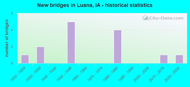
- New bridges - historical statistics
- 11920-1929
- 21930-1939
- 51950-1959
- 41980-1989
- 12010-2019
- 12020-2022

- Bridge Condition - Deck
- 12.5%Very good
- 25.0%Good
- 37.5%Satisfactory
- 25.0%Fair

- Bridge Condition - Superstructure
- 25.0%Very good
- 25.0%Good
- 25.0%Satisfactory
- 25.0%Fair

- Bridge Condition - Substructure
- 25.0%Very good
- 50.0%Satisfactory
- 12.5%Fair
- 12.5%Poor

- Bridge Condition - Channel
- 21.4%Very good
- 21.4%Good
- 42.9%Satisfactory
- 14.3%Fair

- Bridge Condition - Culverts
- 16.7%Very good
- 50.0%Good
- 16.7%Satisfactory
- 16.7%Fair
Find on map >> Show street view
Structure Number: 614, Location: 096051904 (Lat: 43.119292, Lng: -91.478986), Route carried "on" structure: County highway , Year Built: 1958, Status: Open, Structure Length: 0.82m (2.69ft), Average Daily Traffic: 520 (year 2021), Truck Traffic: 20%, Average Future Daily Traffic: 520 (year 2040), Features Intersected: BRANCH WILLIAMS CREEK, Facility Carried by Structure: FM
Minimum Vertical Clearance: 30+ m (98+ ft), Kilometerpoint: 4.456, Lanes on structure: 2, Owner: County Highway Agency, Approaching Roadway Width: 9.1m (29.9ft), Skew: 3 degrees, Material/Design: Concrete continuous, Design/Construction: Culvert, Number Of Spans In Main Unit: 2, Length of Maximum Span: 3.7m (12.1ft)
Condition: Channel: Fair, Culverts: Fair, Operating Rating: 23.2 metric tons, Method Used To Determine Operating Rating: Field evaluation and documented engineering judgment, Inventory Rating: 17.0 metric tons, Method Used To Determine Inventory Rating: Field evaluation and documented engineering judgment, Structural Evaluation: Meets minimum limits, Waterway Adequacy: Somewhat better than minimum adequacy, Approach Roadway Alignment: Equal to present minimum criteria, Designated Inspection Frequency: Every 24 months, Inspection Date: April 2020
Find on map >> Show street view
Structure Number: 6141, Location: 096051905 (Lat: 43.122239, Lng: -91.471739), Route carried "on" structure: County highway , Year Built: 1958, Status: Open, Structure Length: 0.94m (3.08ft), Average Daily Traffic: 600 (year 2021), Average Future Daily Traffic: 600 (year 2040), Features Intersected: BRANCH WILLIAMS CREEK, Facility Carried by Structure: FM
Minimum Vertical Clearance: 30+ m (98+ ft), Kilometerpoint: 5.147, Lanes on structure: 2, Owner: County Highway Agency, Approaching Roadway Width: 9.8m (32.2ft), Material/Design: Concrete continuous, Design/Construction: Culvert, Number Of Spans In Main Unit: 2, Length of Maximum Span: 4.3m (14.1ft)
Condition: Channel: Satisfactory, Culverts: Satisfactory, Operating Rating: 23.2 metric tons, Method Used To Determine Operating Rating: Field evaluation and documented engineering judgment, Inventory Rating: 17.0 metric tons, Method Used To Determine Inventory Rating: Field evaluation and documented engineering judgment, Structural Evaluation: Meets minimum limits, Waterway Adequacy: Equal to present minimum criteria, Approach Roadway Alignment: Equal to present minimum criteria, Designated Inspection Frequency: Every 24 months, Inspection Date: April 2020
Find on map >> Show street view
Structure Number: 61491, Location: 096053304 (Lat: 43.095831, Lng: -91.434539), Route carried "on" structure: County highway , Year Built: 1982, Status: Open, Structure Length: 3.51m (11.52ft), Average Daily Traffic: 70 (year 2017), Average Future Daily Traffic: 70 (year 2040), Design Load: H 20, Features Intersected: HICKORY CREEK, Facility Carried by Structure: LOCAL
Minimum Vertical Clearance: 30+ m (98+ ft), Kilometerpoint: 5.089, Lanes on structure: 2, Owner: County Highway Agency, Approaching Roadway Width: 7.9m (25.9ft), Skew: 3 degrees, Material/Design: Concrete continuous, Design/Construction: Slab, Number Of Spans In Main Unit: 3, Length of Maximum Span: 13.4m (44.0ft), Curb-To-Curb Width: 7.3m (24.0ft), Out-to-Out Width: 8.3m (27.2ft)
Condition: Deck: Satisfactory, Superstructure: Satisfactory, Substructure: Satisfactory, Channel: Fair, Operating Rating: 38.9 metric tons, Method Used To Determine Operating Rating: Load and Resistance Factor Rating (LRFR) rating reported by rating factor(RF) method using HL-93 loadings, Inventory Rating: 30.1 metric tons, Method Used To Determine Inventory Rating: Load and Resistance Factor Rating (LRFR) rating reported by rating factor(RF) method using HL-93 loadings, Structural Evaluation: Equal to present minimum criteria, Deck Geometry: Equal to present minimum criteria, Waterway Adequacy: Better than present minimum criteria, Approach Roadway Alignment: Equal to present minimum criteria, Designated Inspection Frequency: Every 24 months, Inspection Date: April 2020, Deck Structure Type: Concrete Cast-file-Place, Wearing Surface/Protective System: Wearing Surface: Monolithic Concrete
Find on map >> Show street view
Structure Number: 121121, Location: On Blackberry Rd (Lat: 43.072006, Lng: -91.454722), Route carried "on" structure: County highway , Year Built: 2013, Status: Open, Structure Length: 3.05m (10.01ft), Average Daily Traffic: 100 (year 2021), Average Future Daily Traffic: 100 (year 2040), Design Load: HS 20, Features Intersected: HICKORY CREEK, Facility Carried by Structure: DOLPHIN AVE
Minimum Vertical Clearance: 30+ m (98+ ft), Kilometerpoint: 10.607, Lanes on structure: 2, Owner: County Highway Agency, Approaching Roadway Width: 7.9m (25.9ft), Skew: 3 degrees, Material/Design: Concrete continuous, Design/Construction: Slab, Number Of Spans In Main Unit: 3, Length of Maximum Span: 11.9m (39.0ft), Curb-To-Curb Width: 9.3m (30.5ft), Out-to-Out Width: 10.1m (33.1ft)
Condition: Deck: Good, Superstructure: Very good, Substructure: Very good, Channel: Very good, Operating Rating: 67.6 metric tons, Method Used To Determine Operating Rating: Load Factor (LF), Inventory Rating: 40.5 metric tons, Method Used To Determine Inventory Rating: Load Factor (LF), Structural Evaluation: Equal to present desirable criteria, Deck Geometry: Better than present minimum criteria, Waterway Adequacy: Superior to present desirable criteria, Approach Roadway Alignment: Better than present minimum criteria, Designated Inspection Frequency: Every 24 months, Inspection Date: October 2020, Deck Structure Type: Concrete Cast-file-Place, Wearing Surface/Protective System: Wearing Surface: Monolithic Concrete
Find on map >> Show street view
Structure Number: 121131, Location: .1 M S 100th st (Lat: 43.077272, Lng: -91.488986), Route carried "on" structure: County highway , Year Built: 2020, Status: Open, Structure Length: 2.13m (6.99ft), Average Daily Traffic: 15 (year 2013), Average Future Daily Traffic: 15 (year 2040), Design Load: HS 20, Features Intersected: STREAM, Facility Carried by Structure: DOGWOOD AVE
Minimum Vertical Clearance: 30+ m (98+ ft), Kilometerpoint: 16.850, Lanes on structure: 2, Owner: County Highway Agency, Approaching Roadway Width: 7.3m (24.0ft), Material/Design: Concrete continuous, Design/Construction: Slab, Number Of Spans In Main Unit: 3, Length of Maximum Span: 8.5m (27.9ft), Curb-To-Curb Width: 9.1m (29.9ft), Out-to-Out Width: 10.1m (33.1ft)
Condition: Deck: Very good, Superstructure: Very good, Substructure: Very good, Channel: Very good, Operating Rating: 69.7 metric tons, Method Used To Determine Operating Rating: Load Factor (LF), Inventory Rating: 41.8 metric tons, Method Used To Determine Inventory Rating: Load Factor (LF), Structural Evaluation: Equal to present desirable criteria, Deck Geometry: Better than present minimum criteria, Waterway Adequacy: Superior to present desirable criteria, Approach Roadway Alignment: Equal to present desirable criteria, Designated Inspection Frequency: Every 24 months, Inspection Date: December 2020, Deck Structure Type: Concrete Cast-file-Place, Wearing Surface/Protective System: Wearing Surface: Monolithic Concrete
Find on map >> Show street view
Structure Number: 1212, Location: 095052004 (Lat: 43.034136, Lng: -91.458644), Route carried "on" structure: County highway , Year Built: 1953, Status: Open, Structure Length: 1.34m (4.40ft), Average Daily Traffic: 90 (year 2021), Average Future Daily Traffic: 90 (year 2040), Design Load: H 15, Features Intersected: STREAM, Facility Carried by Structure: DOLPHIN AVE
Minimum Vertical Clearance: 30+ m (98+ ft), Kilometerpoint: 7.979, Lanes on structure: 2, Owner: County Highway Agency, Approaching Roadway Width: 7.0m (23.0ft), Skew: 3 degrees, Material/Design: Steel, Design/Construction: Stringer/Multi-beam, Number Of Spans In Main Unit: 1, Length of Maximum Span: 13.1m (43.0ft), Curb-To-Curb Width: 6.1m (20.0ft), Out-to-Out Width: 6.7m (22.0ft)
Condition: Deck: Satisfactory, Superstructure: Good, Substructure: Fair, Channel: Satisfactory, Operating Rating: 34.3 metric tons, Method Used To Determine Operating Rating: Load and Resistance Factor Rating (LRFR) rating reported by rating factor(RF) method using HL-93 loadings, Inventory Rating: 26.2 metric tons, Method Used To Determine Inventory Rating: Load and Resistance Factor Rating (LRFR) rating reported by rating factor(RF) method using HL-93 loadings, Structural Evaluation: Somewhat better than minimum adequacy, Deck Geometry: Somewhat better than minimum adequacy, Waterway Adequacy: Equal to present desirable criteria, Approach Roadway Alignment: Equal to present desirable criteria, Length Of Structure Improvement: 6.00m (19.69ft), Designated Inspection Frequency: Every 24 months, Inspection Date: October 2020, Bridge Improvement Cost: $75,000, Roadway Improvement Cost: $25,000, Deck Structure Type: Concrete Cast-file-Place, Wearing Surface/Protective System: Wearing Surface: Monolithic Concrete
Find on map >> Show street view
Structure Number: 12124, Location: 095052805 (Lat: 43.015333, Lng: -91.431894), Route carried "on" structure: County highway , Year Built: 1925, Status: Posted for load, Structure Length: 0.94m (3.08ft), Average Daily Traffic: 140 (year 2021), Average Future Daily Traffic: 140 (year 2040), Design Load: H 15, Features Intersected: STREAM, Facility Carried by Structure: 145TH ST
Minimum Vertical Clearance: 30+ m (98+ ft), Kilometerpoint: 10.079, Lanes on structure: 1, Owner: County Highway Agency, Approaching Roadway Width: 6.1m (20.0ft), Material/Design: Steel, Design/Construction: Stringer/Multi-beam, Number Of Spans In Main Unit: 1, Length of Maximum Span: 9.1m (29.9ft), Curb-To-Curb Width: 4.5m (14.8ft), Out-to-Out Width: 4.9m (16.1ft)
Condition: Deck: Fair, Superstructure: Fair, Substructure: Satisfactory, Channel: Satisfactory, Operating Rating: 24.3 metric tons, Method Used To Determine Operating Rating: Load and Resistance Factor Rating (LRFR) rating reported by rating factor(RF) method using HL-93 loadings, Inventory Rating: 18.8 metric tons, Method Used To Determine Inventory Rating: Load and Resistance Factor Rating (LRFR) rating reported by rating factor(RF) method using HL-93 loadings, Structural Evaluation: Somewhat better than minimum adequacy, Deck Geometry: High priority of replacement, Waterway Adequacy: Better than present minimum criteria, Approach Roadway Alignment: Equal to present desirable criteria, Bridge Posting: Required (Relationship of Operating Rating to Maximum Legal Load: 20.0 - 29.9% below), Length Of Structure Improvement: 3.00m (9.84ft), Designated Inspection Frequency: Every 24 months, Inspection Date: October 2020, Bridge Improvement Cost: $20,000, Roadway Improvement Cost: $30,000, Deck Structure Type: Concrete Cast-file-Place, Wearing Surface/Protective System: Wearing Surface: Monolithic Concrete
Find on map >> Show street view
Structure Number: 121251, Location: 095052902 (Lat: 43.016511, Lng: -91.468767), Route carried "on" structure: County highway , Year Built: 1984, Status: Open, Structure Length: 0.76m (2.49ft), Average Daily Traffic: 40 (year 2013), Average Future Daily Traffic: 40 (year 2040), Design Load: H 20, Features Intersected: SILVER CREEK, Facility Carried by Structure: DOVE AVE
Minimum Vertical Clearance: 30+ m (98+ ft), Kilometerpoint: 11.998, Lanes on structure: 2, Owner: County Highway Agency, Approaching Roadway Width: 7.9m (25.9ft), Material/Design: Concrete, Design/Construction: Culvert, Number Of Spans In Main Unit: 2, Length of Maximum Span: 3.7m (12.1ft)
Condition: Channel: Good, Culverts: Good, Operating Rating: 32.3 metric tons, Method Used To Determine Operating Rating: Field evaluation and documented engineering judgment, Inventory Rating: 22.5 metric tons, Method Used To Determine Inventory Rating: Field evaluation and documented engineering judgment, Structural Evaluation: Equal to present minimum criteria, Waterway Adequacy: Equal to present desirable criteria, Approach Roadway Alignment: Equal to present minimum criteria, Length Of Structure Improvement: 4.50m (14.76ft), Designated Inspection Frequency: Every 24 months, Inspection Date: October 2020, Bridge Improvement Cost: $32,000, Roadway Improvement Cost: $20,000
Find on map >> Show street view
Structure Number: 121261, Location: 095052903 (Lat: 43.014964, Lng: -91.459067), Route carried "on" structure: County highway , Year Built: 1986, Status: Open, Structure Length: 0.76m (2.49ft), Average Daily Traffic: 70 (year 2021), Average Future Daily Traffic: 70 (year 2040), Design Load: H 20, Features Intersected: SILVER CREEK, Facility Carried by Structure: 145TH ST
Minimum Vertical Clearance: 30+ m (98+ ft), Kilometerpoint: 7.860, Lanes on structure: 2, Owner: County Highway Agency, Approaching Roadway Width: 8.5m (27.9ft), Material/Design: Concrete, Design/Construction: Culvert, Number Of Spans In Main Unit: 2, Length of Maximum Span: 3.7m (12.1ft)
Condition: Channel: Very good, Culverts: Very good, Operating Rating: 32.3 metric tons, Method Used To Determine Operating Rating: Field evaluation and documented engineering judgment, Inventory Rating: 32.3 metric tons, Method Used To Determine Inventory Rating: Field evaluation and documented engineering judgment, Structural Evaluation: Better than present minimum criteria, Waterway Adequacy: Equal to present desirable criteria, Approach Roadway Alignment: Equal to present desirable criteria, Length Of Structure Improvement: 4.50m (14.76ft), Designated Inspection Frequency: Every 24 months, Inspection Date: October 2020, Bridge Improvement Cost: $32,000, Roadway Improvement Cost: $20,000
Find on map >> Show street view
Structure Number: 121271, Location: 095052903 (Lat: 43.013603, Lng: -91.462694), Route carried "on" structure: County highway , Year Built: 1986, Status: Open, Structure Length: 0.76m (2.49ft), Average Daily Traffic: 70 (year 2021), Average Future Daily Traffic: 70 (year 2040), Design Load: HS 20, Features Intersected: SMALL CREEK, Facility Carried by Structure: 145TH ST
Minimum Vertical Clearance: 30+ m (98+ ft), Kilometerpoint: 7.529, Lanes on structure: 2, Owner: County Highway Agency, Approaching Roadway Width: 8.5m (27.9ft), Material/Design: Concrete, Design/Construction: Culvert, Number Of Spans In Main Unit: 2, Length of Maximum Span: 3.7m (12.1ft)
Condition: Channel: Good, Culverts: Good, Operating Rating: 32.3 metric tons, Method Used To Determine Operating Rating: Field evaluation and documented engineering judgment, Inventory Rating: 32.3 metric tons, Method Used To Determine Inventory Rating: Field evaluation and documented engineering judgment, Structural Evaluation: Better than present minimum criteria, Waterway Adequacy: Equal to present desirable criteria, Approach Roadway Alignment: Equal to present desirable criteria, Length Of Structure Improvement: 4.50m (14.76ft), Designated Inspection Frequency: Every 24 months, Inspection Date: October 2020, Bridge Improvement Cost: $32,000, Roadway Improvement Cost: $20,000
Find on map >> Show street view
Structure Number: 12129, Location: 095053002 (Lat: 43.021767, Lng: -91.489133), Route carried "on" structure: County highway , Year Built: 1930, Status: Open, Structure Length: 0.82m (2.69ft), Average Daily Traffic: 100 (year 2021), Average Future Daily Traffic: 100 (year 2040), Features Intersected: SILVER CREEK, Facility Carried by Structure: DOGWOOD AVE
Minimum Vertical Clearance: 30+ m (98+ ft), Kilometerpoint: 10.602, Lanes on structure: 2, Owner: County Highway Agency, Approaching Roadway Width: 7.9m (25.9ft), Material/Design: Concrete, Design/Construction: Culvert, Number Of Spans In Main Unit: 2, Length of Maximum Span: 3.7m (12.1ft), Curb-To-Curb Width: 6.1m (20.0ft), Out-to-Out Width: 6.7m (22.0ft)
Condition: Channel: Good, Culverts: Good, Operating Rating: 32.3 metric tons, Method Used To Determine Operating Rating: Field evaluation and documented engineering judgment, Inventory Rating: 32.3 metric tons, Method Used To Determine Inventory Rating: Field evaluation and documented engineering judgment, Structural Evaluation: Better than present minimum criteria, Deck Geometry: Somewhat better than minimum adequacy, Waterway Adequacy: Better than present minimum criteria, Approach Roadway Alignment: Equal to present desirable criteria, Length Of Structure Improvement: 4.70m (15.42ft), Designated Inspection Frequency: Every 24 months, Inspection Date: October 2020, Bridge Improvement Cost: $34,000, Roadway Improvement Cost: $20,000, Deck Structure Type: Concrete Cast-file-Place, Wearing Surface/Protective System: Wearing Surface: Gravel
Find on map >> Show street view
Structure Number: 12132, Location: 095053306 (Lat: 42.995175, Lng: -91.438964), Route carried "on" structure: County highway , Year Built: 1955, Status: Posted for load, Structure Length: 1.34m (4.40ft), Average Daily Traffic: 70 (year 2021), Average Future Daily Traffic: 70 (year 2040), Design Load: H 15, Features Intersected: STREAM, Facility Carried by Structure: EAGLE RD
Minimum Vertical Clearance: 30+ m (98+ ft), Kilometerpoint: 17.661, Lanes on structure: 2, Owner: County Highway Agency, Approaching Roadway Width: 6.7m (22.0ft), Material/Design: Steel, Design/Construction: Stringer/Multi-beam, Number Of Spans In Main Unit: 1, Length of Maximum Span: 13.1m (43.0ft), Curb-To-Curb Width: 6.1m (20.0ft), Out-to-Out Width: 6.7m (22.0ft)
Condition: Deck: Good, Superstructure: Good, Substructure: Satisfactory, Channel: Satisfactory, Operating Rating: 34.3 metric tons, Method Used To Determine Operating Rating: Load and Resistance Factor Rating (LRFR) rating reported by rating factor(RF) method using HL-93 loadings, Inventory Rating: 26.2 metric tons, Method Used To Determine Inventory Rating: Load and Resistance Factor Rating (LRFR) rating reported by rating factor(RF) method using HL-93 loadings, Structural Evaluation: Equal to present minimum criteria, Deck Geometry: Somewhat better than minimum adequacy, Waterway Adequacy: Equal to present desirable criteria, Approach Roadway Alignment: Equal to present desirable criteria, Bridge Posting: Required (Relationship of Operating Rating to Maximum Legal Load: 10.0 - 19.9% below), Length Of Structure Improvement: 6.50m (21.33ft), Designated Inspection Frequency: Every 24 months, Inspection Date: October 2020, Bridge Improvement Cost: $80,000, Roadway Improvement Cost: $20,000, Deck Structure Type: Concrete Cast-file-Place, Wearing Surface/Protective System: Wearing Surface: Monolithic Concrete
Find on map >> Show street view
Structure Number: 121441, Location: 095062404 (Lat: 43.033000, Lng: -91.503931), Route carried "on" structure: County highway , Year Built: 1938, Status: Posted for load-capacity, Structure Length: 1.16m (3.81ft), Average Daily Traffic: 30 (year 2013), Average Future Daily Traffic: 30 (year 2040), Features Intersected: SILVER CREEK, Facility Carried by Structure: CORAL AVE
Minimum Vertical Clearance: 30+ m (98+ ft), Kilometerpoint: 6.661, Lanes on structure: 2, Owner: County Highway Agency, Approaching Roadway Width: 6.1m (20.0ft), Material/Design: Steel, Design/Construction: Stringer/Multi-beam, Number Of Spans In Main Unit: 1, Length of Maximum Span: 11.3m (37.1ft), Curb-To-Curb Width: 5.5m (18.0ft), Out-to-Out Width: 5.8m (19.0ft)
Condition: Deck: Fair, Superstructure: Fair, Substructure: Poor, Channel: Satisfactory, Operating Rating: 32.1 metric tons, Method Used To Determine Operating Rating: Load and Resistance Factor Rating (LRFR) rating reported by rating factor(RF) method using HL-93 loadings, Inventory Rating: 24.6 metric tons, Method Used To Determine Inventory Rating: Load and Resistance Factor Rating (LRFR) rating reported by rating factor(RF) method using HL-93 loadings, Structural Evaluation: Meets minimum limits, Waterway Adequacy: Equal to present desirable criteria, Approach Roadway Alignment: Equal to present desirable criteria, Bridge Posting: Required (Relationship of Operating Rating to Maximum Legal Load: 0.1 - 9.9% below), Length Of Structure Improvement: 5.80m (19.03ft), Designated Inspection Frequency: Every 24 months, Inspection Date: October 2020, Bridge Improvement Cost: $61,000, Roadway Improvement Cost: $20,000, Deck Structure Type: Wood or Timber, Wearing Surface/Protective System: Wearing Surface: Wood or Timber
Find on map >> Show street view
Structure Number: 12146, Location: 095062605 (Lat: 43.015853, Lng: -91.512214), Route carried "on" structure: County highway , Year Built: 1953, Status: Posted for load, Structure Length: 3.81m (12.50ft), Average Daily Traffic: 50 (year 2021), Average Future Daily Traffic: 50 (year 2040), Design Load: H 15, Features Intersected: ROBERTS CREEK, Facility Carried by Structure: 145TH ST
Minimum Vertical Clearance: 30+ m (98+ ft), Kilometerpoint: 3.212, Lanes on structure: 2, Owner: County Highway Agency, Approaching Roadway Width: 7.6m (24.9ft), Material/Design: Steel continuous, Design/Construction: Stringer/Multi-beam, Number Of Spans In Main Unit: 3, Length of Maximum Span: 14.9m (48.9ft), Curb-To-Curb Width: 6.1m (20.0ft), Out-to-Out Width: 6.6m (21.7ft)
Condition: Deck: Satisfactory, Superstructure: Satisfactory, Substructure: Satisfactory, Channel: Satisfactory, Operating Rating: 20.7 metric tons, Method Used To Determine Operating Rating: Allowable Stress (AS), Inventory Rating: 11.7 metric tons, Method Used To Determine Inventory Rating: Allowable Stress (AS), Structural Evaluation: Meets minimum limits, Deck Geometry: Somewhat better than minimum adequacy, Waterway Adequacy: Better than present minimum criteria, Approach Roadway Alignment: Equal to present minimum criteria, Bridge Posting: Required (Relationship of Operating Rating to Maximum Legal Load: 30.0 - 39.9% below), Length Of Structure Improvement: 15.00m (49.21ft), Designated Inspection Frequency: Every 24 months, Inspection Date: October 2020, Bridge Improvement Cost: $180,000, Roadway Improvement Cost: $30,000, Deck Structure Type: Concrete Cast-file-Place, Wearing Surface/Protective System: Wearing Surface: Monolithic Concrete