Bridge Statistics for Lowell, Michigan (MI)
Condition, Traffic, Stress, Structural Evaluation, Project Costs
- National Bridge Inventory (NBI) Statistics
- 16Number of bridges
- 207ft / 62.9mTotal length
- $33,000Total costs
- 181,561Total average daily traffic
- 22,717Total average daily truck traffic
- National Bridge Inventory (NBI) Registered Bridges for Lowell
- No street view available for this location
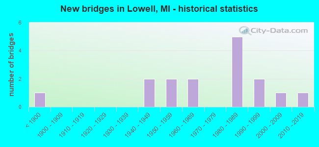
- New bridges - historical statistics
- 1Before 1900
- 21940-1949
- 21950-1959
- 21960-1969
- 51980-1989
- 21990-1999
- 12000-2009
- 12010-2019

- Reconstructed bridges - Historical Statistics
- 21980-1989
- 01990-1999
- 02000-2009
- 32010-2019


- Bridge Condition - Deck
- 10.0%Very good
- 80.0%Good
- 10.0%Fair

- Bridge Condition - Superstructure
- 30.0%Very good
- 50.0%Good
- 10.0%Satisfactory
- 10.0%Fair

- Bridge Condition - Substructure
- 70.0%Good
- 20.0%Satisfactory
- 10.0%Fair

- Bridge Condition - Channel
- 75.0%Very good
- 8.3%Good
- 8.3%Satisfactory
- 8.3%Fair

- Bridge Condition - Culverts
- 75.0%Very good
- 25.0%Satisfactory
Find on map >> Show street view
Structure Number: 502, Location: 1 MI S OF MICHIGAMME (Lat: 46.525678, Lng: -88.123272), Route carried "on" structure: County highway 785, Year Built: 1987, Status: Open, Structure Length: 2.43m (7.97ft), Average Daily Traffic: 237 (year 2014), Truck Traffic: 7%, Average Future Daily Traffic: 300 (year 2034), Design Load: HS 20, Features Intersected: SPURR RIVER, Facility Carried by Structure: IMPERIAL HTS ROAD
Minimum Vertical Clearance: 30+ m (98+ ft), Kilometerpoint: 0.462, Lanes on structure: 2, Owner: County Highway Agency, Approaching Roadway Width: 8.5m (27.9ft), Skew: 3 degrees, Material/Design: Steel, Design/Construction: Stringer/Multi-beam, Number Of Spans In Main Unit: 1, Length of Maximum Span: 22.6m (74.1ft), Curb-To-Curb Width: 9.1m (29.9ft), Out-to-Out Width: 9.8m (32.2ft)
Condition: Deck: Good, Superstructure: Good, Substructure: Good, Channel: Very good, Operating Rating: 90.5 metric tons, Method Used To Determine Operating Rating: Allowable Stress (AS), Inventory Rating: 39.3 metric tons, Method Used To Determine Inventory Rating: Allowable Stress (AS), Structural Evaluation: Better than present minimum criteria, Deck Geometry: Equal to present minimum criteria, Waterway Adequacy: Equal to present desirable criteria, Approach Roadway Alignment: Better than present minimum criteria, Designated Inspection Frequency: Every 24 months, Inspection Date: September 2021, Deck Structure Type: Concrete Cast-file-Place, Wearing Surface/Protective System: Wearing Surface: Monolithic Concrete, Deck Protection: Epoxy Coated Reinforcing
Find on map >> Show street view
Structure Number: 4722, Location: 1.7 MI W OF IONIA COL (Lat: 42.877067, Lng: -85.346186), Route carried "on" structure: County highway , Year Built: 1959, Year Reconstructed: 1980, Status: Open, Structure Length: 6.98m (22.90ft), Average Daily Traffic: 640 (year 1996), Truck Traffic: 6%, Average Future Daily Traffic: 1,156 (year 2016), Design Load: H 20, Features Intersected: I-96, Facility Carried by Structure: SEGWUN RD
Minimum Vertical Clearance: 30.48m (100.00ft), Kilometerpoint: 2.234, Lanes on structure: 2, Lanes under structure: 4, Owner: State Highway Agency, Approaching Roadway Width: 10.3m (33.8ft), Material/Design: Concrete continuous, Design/Construction: Tee Beam, Number Of Spans In Main Unit: 4, Length of Maximum Span: 21.6m (70.9ft), Curb-To-Curb Width: 8.9m (29.2ft), Out-to-Out Width: 10.1m (33.1ft)
Condition: Deck: Fair, Superstructure: Satisfactory, Substructure: Fair, Operating Rating: 55.1 metric tons, Method Used To Determine Operating Rating: Load Factor (LF) rating reported by rating factor (RF) method using MS18 loading, Inventory Rating: 33.0 metric tons, Method Used To Determine Inventory Rating: Load Factor (LF) rating reported by rating factor (RF) method using MS18 loading, Structural Evaluation: Somewhat better than minimum adequacy, Deck Geometry: Somewhat better than minimum adequacy, Underclear: Meets minimum limits, Approach Roadway Alignment: Better than present minimum criteria, Designated Inspection Frequency: Every 24 months, Inspection Date: March 2021, Deck Structure Type: Concrete Cast-file-Place, Wearing Surface/Protective System: Wearing Surface: Monolithic Concrete
Find on map >> Show street view
Structure Number: 4855, Location: IN LOWELL (118 W MAIN ST) (Lat: 42.932808, Lng: -85.345647), Route carried "on" structure: State highway 21, Year Built: 1941, Year Reconstructed: 2010, Status: Open, Structure Length: 2.21m (7.25ft), Average Daily Traffic: 18,836 (year 2007), Truck Traffic: 4%, Average Future Daily Traffic: 14,750 (year 2030), Design Load: Greater than HL93, Features Intersected: FLAT RIVER
Minimum Vertical Clearance: 30.48m (100.00ft), Kilometerpoint: 31.275, Lanes on structure: 4, Base Highway Network: Yes (Inventory Route: 40, Subroute: 5), Owner: State Highway Agency, Approaching Roadway Width: 14.6m (47.9ft), Material/Design: Concrete, Design/Construction: Box Beam or Girders - Single/Spread, Number Of Spans In Main Unit: 2, Length of Maximum Span: 10.4m (34.1ft), Curb or Sidewalk Widths: Left: 3.7m (12.1ft), Right: 4.3m (14.1ft), Curb-To-Curb Width: 14.6m (47.9ft), Out-to-Out Width: 23.4m (76.8ft)
Condition: Deck: Good, Superstructure: Very good, Substructure: Good, Channel: Very good, Operating Rating: 68.6 metric tons, Method Used To Determine Operating Rating: Load Factor (LF), Inventory Rating: 41.1 metric tons, Method Used To Determine Inventory Rating: Load Factor (LF), Structural Evaluation: Better than present minimum criteria, Deck Geometry: High priority of replacement, Waterway Adequacy: Equal to present desirable criteria, Approach Roadway Alignment: Equal to present desirable criteria, Designated Inspection Frequency: Every 24 months, Underwater Inspection Frequency: Every 60 months, Inspection Date: October 2020, Underwater Inspection Date: May 2020, Bridge Improvement Cost: $4,000, Deck Structure Type: Concrete Cast-file-Place, Wearing Surface/Protective System: Wearing Surface: Monolithic Concrete, Deck Protection: Epoxy Coated Reinforcing
Find on map >> Show street view
Structure Number: 4856, Location: IN LOWELL (107 E MAIN ST) (Lat: 42.934408, Lng: -85.338053), Route carried "on" structure: State highway 21, Year Built: 1940, Year Reconstructed: 2010, Status: Open, Structure Length: 1.49m (4.89ft), Average Daily Traffic: 18,836 (year 2007), Truck Traffic: 4%, Average Future Daily Traffic: 14,750 (year 2030), Design Load: Greater than HL93, Features Intersected: FLAT RIVER
Minimum Vertical Clearance: 30.48m (100.00ft), Kilometerpoint: 31.383, Lanes on structure: 4, Base Highway Network: Yes (Inventory Route: 40, Subroute: 5), Owner: State Highway Agency, Approaching Roadway Width: 14.6m (47.9ft), Material/Design: Concrete, Design/Construction: Box Beam or Girders - Single/Spread, Number Of Spans In Main Unit: 1, Length of Maximum Span: 14.1m (46.3ft), Curb or Sidewalk Widths: Left: 4.2m (13.8ft), Right: 3.0m (9.8ft), Curb-To-Curb Width: 14.6m (47.9ft), Out-to-Out Width: 22.6m (74.1ft)
Condition: Deck: Good, Superstructure: Very good, Substructure: Good, Channel: Very good, Operating Rating: 85.1 metric tons, Method Used To Determine Operating Rating: Load Factor (LF), Inventory Rating: 42.7 metric tons, Method Used To Determine Inventory Rating: Load Factor (LF), Structural Evaluation: Better than present minimum criteria, Deck Geometry: High priority of replacement, Waterway Adequacy: Equal to present desirable criteria, Approach Roadway Alignment: Equal to present desirable criteria, Length Of Structure Improvement: 1.49m (4.89ft), Designated Inspection Frequency: Every 24 months, Underwater Inspection Frequency: Every 60 months, Inspection Date: October 2020, Underwater Inspection Date: May 2020, Bridge Improvement Cost: $37,000, Roadway Improvement Cost: $3,000, Total Project Cost: $33,000, Deck Structure Type: Concrete Cast-file-Place, Wearing Surface/Protective System: Wearing Surface: Monolithic Concrete, Deck Protection: Epoxy Coated Reinforcing
Find on map >> Show street view
Structure Number: 502, Location: 50 FT N OF GRAND RIVER DR (Lat: 42.929133, Lng: -85.331517), Route carried "on" structure: County highway , Year Built: 1982, Status: Open, Structure Length: 11.00m (36.09ft), Average Daily Traffic: 1,830 (year 2008), Average Future Daily Traffic: 3,110 (year 2028), Design Load: HS 20+Mod, Features Intersected: GRAND RIVER, Facility Carried by Structure: DIVISION ST
Minimum Vertical Clearance: 30.48m (100.00ft), Kilometerpoint: 0.423, Lanes on structure: 2, Owner: County Highway Agency, Approaching Roadway Width: 11.6m (38.1ft), Material/Design: Prestressed concrete, Design/Construction: Box Beam or Girders - Multiple, Number Of Spans In Main Unit: 5, Length of Maximum Span: 21.9m (71.9ft), Curb-To-Curb Width: 11.6m (38.1ft), Out-to-Out Width: 12.9m (42.3ft)
Condition: Deck: Good, Superstructure: Good, Substructure: Good, Channel: Satisfactory, Operating Rating: 78.9 metric tons, Method Used To Determine Operating Rating: Load Factor (LF), Inventory Rating: 47.3 metric tons, Method Used To Determine Inventory Rating: Load Factor (LF), Structural Evaluation: Better than present minimum criteria, Deck Geometry: Equal to present minimum criteria, Waterway Adequacy: Equal to present desirable criteria, Approach Roadway Alignment: Better than present minimum criteria, Designated Inspection Frequency: Every 24 months, Inspection Date: November 2021, Deck Structure Type: Concrete Cast-file-Place, Wearing Surface/Protective System: Wearing Surface: Bituminous, Membrane: Preformed Fabric, Deck Protection: Epoxy Coated Reinforcing
Find on map >> Show street view
Structure Number: 5083, Location: 300' NE OF COVERED BRIDGE (Lat: 42.983297, Lng: -85.340622), Route carried "on" structure: County highway , Year Built: 1987, Status: Open, Structure Length: 0.73m (2.40ft), Average Daily Traffic: 1,026 (year 2005), Truck Traffic: 5%, Average Future Daily Traffic: 1,740 (year 2025), Design Load: H 20, Features Intersected: PAGE CREEK, Facility Carried by Structure: FALLASBURG PARK DR
Minimum Vertical Clearance: 30.48m (100.00ft), Kilometerpoint: 1.263, Lanes on structure: 2, Owner: County Highway Agency, Approaching Roadway Width: 9.8m (32.2ft), Skew: 2 degrees, Material/Design: Concrete, Design/Construction: Culvert, Number Of Spans In Main Unit: 2, Length of Maximum Span: 3.3m (10.8ft)
Condition: Channel: Very good, Culverts: Very good, Operating Rating: 47.6 metric tons, Method Used To Determine Operating Rating: Load Factor (LF) rating reported by rating factor (RF) method using MS18 loading, Inventory Rating: 36.6 metric tons, Method Used To Determine Inventory Rating: Load Factor (LF) rating reported by rating factor (RF) method using MS18 loading, Structural Evaluation: Equal to present desirable criteria, Waterway Adequacy: Equal to present desirable criteria, Approach Roadway Alignment: Equal to present desirable criteria, Designated Inspection Frequency: Every 24 months, Inspection Date: September 2020, Deck Structure Type: Concrete Cast-file-Place
Find on map >> Show street view
Structure Number: 5085, Location: 450 FT E OF FALLSBG PK DR (Lat: 42.986669, Lng: -85.332397), Route carried "on" structure: County highway , Year Built: 1969, Status: Open, Structure Length: 9.17m (30.09ft), Average Daily Traffic: 691 (year 2005), Average Future Daily Traffic: 1,170 (year 2025), Design Load: HS 20+Mod, Features Intersected: FLAT RIVER, Facility Carried by Structure: MCPHERSON STREET
Minimum Vertical Clearance: 30.48m (100.00ft), Kilometerpoint: 0.164, Lanes on structure: 2, Owner: County Highway Agency, Approaching Roadway Width: 10.4m (34.1ft), Material/Design: Prestressed concrete, Design/Construction: Box Beam or Girders - Multiple, Number Of Spans In Main Unit: 4, Length of Maximum Span: 23.1m (75.8ft), Curb-To-Curb Width: 10.1m (33.1ft), Out-to-Out Width: 11.1m (36.4ft)
Condition: Deck: Good, Superstructure: Fair, Substructure: Satisfactory, Channel: Very good, Operating Rating: 67.6 metric tons, Method Used To Determine Operating Rating: Load Factor (LF), Inventory Rating: 36.9 metric tons, Method Used To Determine Inventory Rating: Load Factor (LF), Structural Evaluation: Somewhat better than minimum adequacy, Deck Geometry: Equal to present minimum criteria, Waterway Adequacy: Equal to present desirable criteria, Approach Roadway Alignment: Equal to present desirable criteria, Designated Inspection Frequency: Every 24 months, Inspection Date: April 2021, Deck Structure Type: Concrete Precast Panels, Wearing Surface/Protective System: Wearing Surface: Bituminous
Find on map >> Show street view
Structure Number: 5088, Location: 0.25 MI N OF VERGENNES ST (Lat: 42.960753, Lng: -85.332600), Route carried "on" structure: County highway 4195, Year Built: 1990, Status: Open, Structure Length: 4.57m (14.99ft), Average Daily Traffic: 2,776 (year 2004), Truck Traffic: 5%, Average Future Daily Traffic: 4,720 (year 2024), Design Load: HS 20+Mod, Features Intersected: FLAT RIVER, Facility Carried by Structure: FLAT RIVER DRIVE
Minimum Vertical Clearance: 30.48m (100.00ft), Kilometerpoint: 3.322, Lanes on structure: 2, Owner: County Highway Agency, Approaching Roadway Width: 12.2m (40.0ft), Material/Design: Prestressed concrete, Design/Construction: Stringer/Multi-beam, Number Of Spans In Main Unit: 2, Length of Maximum Span: 22.8m (74.8ft), Curb-To-Curb Width: 12.2m (40.0ft), Out-to-Out Width: 12.9m (42.3ft)
Condition: Deck: Very good, Superstructure: Very good, Substructure: Good, Channel: Very good, Operating Rating: 74.1 metric tons, Method Used To Determine Operating Rating: Load Factor (LF), Inventory Rating: 37.1 metric tons, Method Used To Determine Inventory Rating: Load Factor (LF), Structural Evaluation: Better than present minimum criteria, Deck Geometry: Equal to present minimum criteria, Waterway Adequacy: Equal to present desirable criteria, Approach Roadway Alignment: Equal to present desirable criteria, Designated Inspection Frequency: Every 24 months, Inspection Date: September 2020, Deck Structure Type: Concrete Precast Panels, Wearing Surface/Protective System: Wearing Surface: Monolithic Concrete, Deck Protection: Epoxy Coated Reinforcing
Find on map >> Show street view
Structure Number: 5089, Location: 0.25 MI N OF BURROUGHS ST (Lat: 42.964067, Lng: -85.329006), Route carried "on" structure: County highway 4194, Year Built: 1989, Status: Open, Structure Length: 1.15m (3.77ft), Average Daily Traffic: 2,667 (year 2004), Truck Traffic: 5%, Average Future Daily Traffic: 4,530 (year 2024), Design Load: HS 20+Mod, Features Intersected: MILL RACE, Facility Carried by Structure: FLAT RIVER DRIVE
Minimum Vertical Clearance: 30.48m (100.00ft), Kilometerpoint: 3.806, Lanes on structure: 2, Owner: County Highway Agency, Approaching Roadway Width: 12.2m (40.0ft), Skew: 3 degrees, Material/Design: Concrete, Design/Construction: Culvert, Number Of Spans In Main Unit: 1, Length of Maximum Span: 10.9m (35.8ft)
Condition: Channel: Very good, Culverts: Very good, Operating Rating: 42.1 metric tons, Method Used To Determine Operating Rating: Load Factor (LF) rating reported by rating factor (RF) method using MS18 loading, Inventory Rating: 32.4 metric tons, Method Used To Determine Inventory Rating: Load Factor (LF) rating reported by rating factor (RF) method using MS18 loading, Structural Evaluation: Equal to present desirable criteria, Waterway Adequacy: Equal to present desirable criteria, Approach Roadway Alignment: Better than present minimum criteria, Designated Inspection Frequency: Every 24 months, Inspection Date: September 2020
Find on map >> Show street view
Structure Number: 5091, Location: 250 FT N OF GRANDRIVER DR (Lat: 42.925006, Lng: -85.342864), Route carried "on" structure: City street 4183, Year Built: 1967, Year Reconstructed: 2015, Status: Open, Structure Length: 14.74m (48.36ft), Average Daily Traffic: 13,483 (year 2014), Truck Traffic: 8%, Average Future Daily Traffic: 17,528 (year 2034), Design Load: HS 20+Mod, Features Intersected: GRAND RIVER, Facility Carried by Structure: HUDSON STREET
Minimum Vertical Clearance: 30.48m (100.00ft), Kilometerpoint: 6.301, Lanes on structure: 2, Owner: County Highway Agency, Approaching Roadway Width: 13.4m (44.0ft), Skew: 1 degrees, Material/Design: Prestressed concrete, Design/Construction: Stringer/Multi-beam, Number Of Spans In Main Unit: 8, Length of Maximum Span: 18.7m (61.4ft), Curb or Sidewalk Widths: Left: 0.9m (3.0ft), Right: 0.9m (3.0ft), Curb-To-Curb Width: 8.5m (27.9ft), Out-to-Out Width: 10.9m (35.8ft)
Condition: Deck: Good, Superstructure: Good, Substructure: Satisfactory, Channel: Fair, Operating Rating: 95.1 metric tons, Method Used To Determine Operating Rating: Load Factor (LF), Inventory Rating: 57.0 metric tons, Method Used To Determine Inventory Rating: Load Factor (LF), Structural Evaluation: Equal to present minimum criteria, Deck Geometry: Meets minimum limits, Waterway Adequacy: Equal to present desirable criteria, Approach Roadway Alignment: Equal to present desirable criteria, Designated Inspection Frequency: Every 24 months, Inspection Date: November 2021, Deck Structure Type: Concrete Cast-file-Place, Wearing Surface/Protective System: Wearing Surface: Latex Concrete
Find on map >> Show street view
Structure Number: 5149, Location: 0.6 MI S OF 3 MILE RD (Lat: 43.007400, Lng: -85.322061), Route carried "on" structure: County highway , Year Built: 1985, Status: Open, Structure Length: 0.91m (2.99ft), Average Daily Traffic: 230 (year 2005), Truck Traffic: 5%, Average Future Daily Traffic: 390 (year 2025), Design Load: H 20, Features Intersected: PAGE CREEK, Facility Carried by Structure: FALLASBURG PARK DR
Minimum Vertical Clearance: 30.48m (100.00ft), Kilometerpoint: 4.859, Lanes on structure: 2, Owner: County Highway Agency, Approaching Roadway Width: 7.9m (25.9ft), Material/Design: Concrete, Design/Construction: Culvert, Number Of Spans In Main Unit: 2, Length of Maximum Span: 3.9m (12.8ft)
Condition: Channel: Good, Culverts: Very good, Operating Rating: 60.9 metric tons, Method Used To Determine Operating Rating: Load Factor (LF) rating reported by rating factor (RF) method using MS18 loading, Inventory Rating: 55.4 metric tons, Method Used To Determine Inventory Rating: Load Factor (LF) rating reported by rating factor (RF) method using MS18 loading, Structural Evaluation: Equal to present desirable criteria, Waterway Adequacy: Equal to present desirable criteria, Approach Roadway Alignment: Equal to present desirable criteria, Designated Inspection Frequency: Every 24 months, Inspection Date: September 2020
Find on map >> Show street view
Structure Number: 5182, Location: 0.25 MI E OF LINCOLN LK A (Lat: 42.965719, Lng: -85.350950), Route carried "on" structure: County highway , Year Built: 1995, Status: Open, Structure Length: 3.81m (12.50ft), Average Daily Traffic: 965 (year 2015), Truck Traffic: 8%, Average Future Daily Traffic: 1,544 (year 2035), Design Load: HS 20+Mod, Features Intersected: FLAT RIVER, Facility Carried by Structure: BURROUGHS ST
Minimum Vertical Clearance: 30.48m (100.00ft), Kilometerpoint: 0.443, Lanes on structure: 2, Owner: County Highway Agency, Approaching Roadway Width: 9.1m (29.9ft), Material/Design: Steel, Design/Construction: Truss - Thru, Number Of Spans In Main Unit: 1, Length of Maximum Span: 36.6m (120.1ft), Curb or Sidewalk Widths: Left: 1.5m (4.9ft), Right: 1.5m (4.9ft), Curb-To-Curb Width: 8.2m (26.9ft), Out-to-Out Width: 13.4m (44.0ft)
Condition: Deck: Good, Superstructure: Good, Substructure: Good, Channel: Very good, Operating Rating: 52.9 metric tons, Method Used To Determine Operating Rating: Load Factor (LF), Inventory Rating: 31.7 metric tons, Method Used To Determine Inventory Rating: Load Factor (LF), Structural Evaluation: Better than present minimum criteria, Deck Geometry: Somewhat better than minimum adequacy, Waterway Adequacy: Equal to present desirable criteria, Approach Roadway Alignment: Meets minimum limits, Designated Inspection Frequency: Every 24 months, Inspection Date: September 2020, Deck Structure Type: Concrete Cast-file-Place, Wearing Surface/Protective System: Wearing Surface: Monolithic Concrete, Membrane: Epoxy, Deck Protection: Epoxy Coated Reinforcing
Find on map >> Show street view
Structure Number: 5183, Location: 0.8 MI E OF BIGGS AVE (Lat: 42.980444, Lng: -85.326642), Route carried "on" structure: County highway , Year Built: 1871, Year Reconstructed: 1994, Status: Posted for load, Structure Length: 2.98m (9.78ft), Average Daily Traffic: 122 (year 1996), Average Future Daily Traffic: 220 (year 2016), Design Load: HS 20+Mod, Features Intersected: FLAT RIVER, Facility Carried by Structure: COVERED BRIDGE RD
Minimum Vertical Clearance: 3.02m (9.91ft), Kilometerpoint: 1.339, Lanes on structure: 2, Owner: County Highway Agency, Approaching Roadway Width: 6.7m (22.0ft), Material/Design: Wood or Timber, Design/Construction: Truss - Thru, Number Of Spans In Main Unit: 1, Length of Maximum Span: 29.2m (95.8ft), Curb-To-Curb Width: 4.3m (14.1ft), Out-to-Out Width: 5.5m (18.0ft)
Condition: Deck: Good, Superstructure: Good, Substructure: Good, Channel: Very good, Operating Rating: 2.7 metric tons, Method Used To Determine Operating Rating: Allowable Stress (AS), Inventory Rating: 2.5 metric tons, Method Used To Determine Inventory Rating: Allowable Stress (AS), Structural Evaluation: High priority of corrective action, Deck Geometry: High priority of replacement, Waterway Adequacy: Equal to present desirable criteria, Approach Roadway Alignment: Meets minimum limits, Bridge Posting: Required (Relationship of Operating Rating to Maximum Legal Load: > 39.9% below), Designated Inspection Frequency: Every 24 months, Inspection Date: September 2020, Deck Structure Type: Wood or Timber, Wearing Surface/Protective System: Wearing Surface: Wood or Timber
Find on map >> Show street view
Structure Number: 13395, Location: 3 MI E OF M-50 (Lat: 42.877247, Lng: -85.305133), Route carried "on" structure: Interstate 96, Year Built: 2008, Status: Open, Structure Length: 0.68m (2.23ft), Average Daily Traffic: 30,250 (year 2008), Truck Traffic: 18%, Average Future Daily Traffic: 32,000 (year 2028), Design Load: HS 25 or greater, Features Intersected: RAILS TO TRAILS
Minimum Vertical Clearance: 30.48m (100.00ft), Kilometerpoint: 48.984, Lanes on structure: 4, Base Highway Network: Yes (Inventory Route: 40, Subroute: 6), Owner: State Highway Agency, Approaching Roadway Width: 26.4m (86.6ft), Skew: 3 degrees, Material/Design: Concrete, Design/Construction: Culvert, Number Of Spans In Main Unit: 1, Length of Maximum Span: 6.1m (20.0ft), Out-to-Out Width: 73.6m (241.5ft)
Condition: Culverts: Satisfactory, Operating Rating: 97.2 metric tons, Method Used To Determine Operating Rating: Load Factor (LF) rating reported by rating factor (RF) method using MS18 loading, Inventory Rating: 97.2 metric tons, Method Used To Determine Inventory Rating: Load Factor (LF) rating reported by rating factor (RF) method using MS18 loading, Structural Evaluation: Equal to present minimum criteria, Approach Roadway Alignment: Equal to present desirable criteria, Designated Inspection Frequency: Every 24 months, Inspection Date: March 2022
Find on map >> Show street view
Structure Number: 4721, Location: @ M-50 (Lat: 42.878592, Lng: -85.370975), Route carried "under" structure: Interstate 96, Year Built: 2014, Structure Length: 0. m, Average Daily Traffic: 44,600 (year 2012), Truck Traffic: 11%, Features Intersected: I-96, Facility Carried by Structure: M-50
Minimum Vertical Clearance: 4.82m (15.81ft), Kilometerpoint: 44.038, Lanes on structure: 4, Lanes under structure: 4, Material/Design: Prestressed concrete, Design/Construction: Box Beam or Girders - Single/Spread, Length of Maximum Span: 21.6m (70.9ft)
Find on map >> Show street view
Structure Number: 4722, Location: 1.7 MI W OF IONIA COL (Lat: 42.877067, Lng: -85.346186), Route carried "under" structure: Interstate 96, Year Built: 1959, Structure Length: 0. m, Average Daily Traffic: 44,372 (year 2007), Truck Traffic: 21%, Features Intersected: I-96, Facility Carried by Structure: SEGWUN RD
Minimum Vertical Clearance: 4.88m (16.01ft), Kilometerpoint: 46.077, Lanes on structure: 2, Lanes under structure: 4, Material/Design: Concrete continuous, Design/Construction: Tee Beam, Length of Maximum Span: 21.6m (70.9ft)