Bridge Statistics for Los Alamos, California (CA)
Condition, Traffic, Stress, Structural Evaluation, Project Costs
- National Bridge Inventory (NBI) Statistics
- 10Number of bridges
- 56ft / 16.9mTotal length
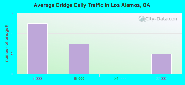
- 109,223Total average daily traffic
- 13,723Total average daily truck traffic
- National Bridge Inventory (NBI) Registered Bridges for Los Alamos
- No street view available for this location
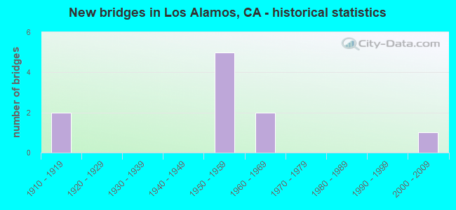
- New bridges - historical statistics
- 21910-1919
- 51950-1959
- 21960-1969
- 12000-2009
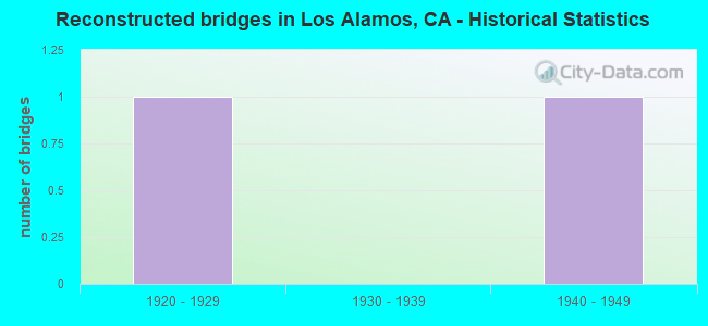
- Reconstructed bridges - Historical Statistics
- 11920-1929
- 01930-1939
- 11940-1949
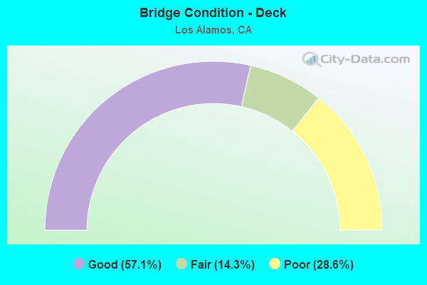
- Bridge Condition - Deck
- 57.1%Good
- 14.3%Fair
- 28.6%Poor
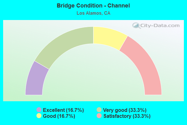
- Bridge Condition - Channel
- 16.7%Excellent
- 33.3%Very good
- 16.7%Good
- 33.3%Satisfactory
Find on map >> Show street view
Structure Number: 51 0008, Location: 05-SB-101-67.41 (Lat: 34.724000, Lng: -120.214125), Route carried "on" structure: US 101, Year Built: 1916, Year Reconstructed: 1954, Status: Open, Structure Length: 0.88m (2.89ft), Average Daily Traffic: 29,000 (year 2009), Truck Traffic: 13%, Average Future Daily Traffic: 58,406 (year 2042), Features Intersected: SAN ANTONIO CREEK
Minimum Vertical Clearance: 30+ m (98+ ft), Kilometerpoint: 67.410, Lanes on structure: 4, Base Highway Network: Yes (Inventory Route: 1, Subroute: 1), Owner: State Highway Agency, Approaching Roadway Width: 21.9m (71.9ft), Skew: 20 degrees, Material/Design: Concrete, Design/Construction: Girder and Floorbeam System, Number Of Spans In Main Unit: 1, Length of Maximum Span: 8.5m (27.9ft), Curb-To-Curb Width: 21.9m (71.9ft), Out-to-Out Width: 21.9m (71.9ft)
Condition: Deck: Good, Superstructure: Good, Substructure: Good, Channel: Very good, Operating Rating: 50.5 metric tons, Method Used To Determine Operating Rating: Load Factor (LF), Inventory Rating: 30.5 metric tons, Method Used To Determine Inventory Rating: Load Factor (LF), Structural Evaluation: Better than present minimum criteria, Deck Geometry: Superior to present desirable criteria, Waterway Adequacy: Equal to present minimum criteria, Approach Roadway Alignment: Equal to present desirable criteria, Designated Inspection Frequency: Every 24 months, Inspection Date: May 2021, Deck Structure Type: Concrete Cast-file-Place, Wearing Surface/Protective System: Wearing Surface: Bituminous
Find on map >> Show street view
Structure Number: 51 0009R, Location: 05-SB-101-67.09 (Lat: 34.721978, Lng: -120.209158), Route carried "on" structure: US 101, Year Built: 1916, Year Reconstructed: 1931, Status: Open, Structure Length: 0.85m (2.79ft), Average Daily Traffic: 14,500 (year 2009), Truck Traffic: 13%, Average Future Daily Traffic: 29,203 (year 2042), Features Intersected: SAN ANTONIO CREEK
Minimum Vertical Clearance: 30+ m (98+ ft), Kilometerpoint: 67.090, Lanes on structure: 2, Base Highway Network: Yes (Inventory Route: 1, Subroute: 1), Owner: State Highway Agency, Approaching Roadway Width: 11.5m (37.7ft), Material/Design: Concrete, Design/Construction: Tee Beam, Number Of Spans In Main Unit: 1, Length of Maximum Span: 8.2m (26.9ft), Curb-To-Curb Width: 11.5m (37.7ft), Out-to-Out Width: 15.2m (49.9ft)
Condition: Deck: Fair, Superstructure: Good, Substructure: Good, Channel: Very good, Operating Rating: 21.7 metric tons, Method Used To Determine Operating Rating: Load and Resistance Factor Rating (LRFR) rating reported by rating factor(RF) method using HL-93 loadings, Inventory Rating: 16.8 metric tons, Method Used To Determine Inventory Rating: Load and Resistance Factor Rating (LRFR) rating reported by rating factor(RF) method using HL-93 loadings, Structural Evaluation: Meets minimum limits, Deck Geometry: Equal to present minimum criteria, Waterway Adequacy: Equal to present minimum criteria, Approach Roadway Alignment: Equal to present desirable criteria, Designated Inspection Frequency: Every 24 months, Inspection Date: May 2021, Deck Structure Type: Concrete Cast-file-Place, Wearing Surface/Protective System: Wearing Surface: Bituminous
Find on map >> Show street view
Structure Number: 51 0067, Location: 05-SB-101-70.99 (Lat: 34.743286, Lng: -120.271625), Route carried "on" structure: US 101, Year Built: 1958, Status: Open, Structure Length: 1.04m (3.41ft), Average Daily Traffic: 29,000 (year 2009), Truck Traffic: 13%, Average Future Daily Traffic: 59,386 (year 2042), Features Intersected: SAN ANTONIO CREEK
Minimum Vertical Clearance: 30+ m (98+ ft), Kilometerpoint: 70.990, Lanes on structure: 4, Base Highway Network: Yes (Inventory Route: 1, Subroute: 1), Owner: State Highway Agency, Approaching Roadway Width: 14.6m (47.9ft), Skew: 1 degrees, Material/Design: Concrete continuous, Design/Construction: Culvert, Number Of Spans In Main Unit: 3, Length of Maximum Span: 3.0m (9.8ft)
Condition: Channel: Good, Culverts: Satisfactory, Operating Rating: 54.1 metric tons, Method Used To Determine Operating Rating: Field evaluation and documented engineering judgment, Inventory Rating: 32.4 metric tons, Method Used To Determine Inventory Rating: Field evaluation and documented engineering judgment, Structural Evaluation: Equal to present minimum criteria, Waterway Adequacy: Equal to present desirable criteria, Approach Roadway Alignment: Equal to present desirable criteria, Designated Inspection Frequency: Every 24 months, Inspection Date: December 2020
Find on map >> Show street view
Structure Number: 51 0073L, Location: 05-SB-101-70.91 (Lat: 34.742431, Lng: -120.270739), Route carried "on" structure: US 101, Year Built: 1958, Status: Open, Structure Length: 3.81m (12.50ft), Average Daily Traffic: 14,500 (year 2009), Truck Traffic: 13%, Average Future Daily Traffic: 29,692 (year 2042), Design Load: HS 20, Features Intersected: STATE ROUTE 135
Minimum Vertical Clearance: 30+ m (98+ ft), Kilometerpoint: 70.910, Lanes on structure: 2, Lanes under structure: 2, Base Highway Network: Yes (Inventory Route: 1, Subroute: 1), Owner: State Highway Agency, Approaching Roadway Width: 10.4m (34.1ft), Skew: 3 degrees, Material/Design: Concrete continuous, Design/Construction: Tee Beam, Number Of Spans In Main Unit: 3, Length of Maximum Span: 18.3m (60.0ft), Curb-To-Curb Width: 11.8m (38.7ft), Out-to-Out Width: 12.9m (42.3ft)
Condition: Deck: Poor, Superstructure: Good, Substructure: Good, Operating Rating: 44.1 metric tons, Method Used To Determine Operating Rating: Load and Resistance Factor Rating (LRFR) rating reported by rating factor(RF) method using HL-93 loadings, Inventory Rating: 34.0 metric tons, Method Used To Determine Inventory Rating: Load and Resistance Factor Rating (LRFR) rating reported by rating factor(RF) method using HL-93 loadings, Structural Evaluation: Better than present minimum criteria, Deck Geometry: Better than present minimum criteria, Underclear: Superior to present desirable criteria, Approach Roadway Alignment: Equal to present desirable criteria, Designated Inspection Frequency: Every 24 months, Inspection Date: December 2020, Deck Structure Type: Concrete Cast-file-Place
Find on map >> Show street view
Structure Number: 51 0073R, Location: 05-SB-101-70.91 (Lat: 34.742511, Lng: -120.270472), Route carried "on" structure: US 101, Year Built: 1958, Status: Open, Structure Length: 3.81m (12.50ft), Average Daily Traffic: 14,500 (year 2009), Truck Traffic: 13%, Average Future Daily Traffic: 29,692 (year 2042), Design Load: HS 20, Features Intersected: STATE ROUTE 135
Minimum Vertical Clearance: 30+ m (98+ ft), Kilometerpoint: 70.910, Lanes on structure: 2, Lanes under structure: 2, Base Highway Network: Yes (Inventory Route: 1, Subroute: 1), Owner: State Highway Agency, Approaching Roadway Width: 10.4m (34.1ft), Skew: 3 degrees, Material/Design: Concrete continuous, Design/Construction: Tee Beam, Number Of Spans In Main Unit: 3, Length of Maximum Span: 18.3m (60.0ft), Curb-To-Curb Width: 11.8m (38.7ft), Out-to-Out Width: 12.9m (42.3ft)
Condition: Deck: Poor, Superstructure: Good, Substructure: Good, Operating Rating: 44.1 metric tons, Method Used To Determine Operating Rating: Load and Resistance Factor Rating (LRFR) rating reported by rating factor(RF) method using HL-93 loadings, Inventory Rating: 34.0 metric tons, Method Used To Determine Inventory Rating: Load and Resistance Factor Rating (LRFR) rating reported by rating factor(RF) method using HL-93 loadings, Structural Evaluation: Better than present minimum criteria, Deck Geometry: Better than present minimum criteria, Underclear: Better than present minimum criteria, Approach Roadway Alignment: Equal to present desirable criteria, Designated Inspection Frequency: Every 24 months, Inspection Date: December 2020, Deck Structure Type: Concrete Cast-file-Place
Find on map >> Show street view
Structure Number: 51C0157, Location: 0.5 MI N OF SR 135 (Lat: 34.749753, Lng: -120.291100), Route carried "on" structure: ServiceCounty highway , Year Built: 2004, Status: Open, Structure Length: 3.45m (11.32ft), Average Daily Traffic: 815 (year 2005), Truck Traffic: 16%, Average Future Daily Traffic: 3,258 (year 2038), Design Load: HS 20+Mod, Features Intersected: SAN ANTONIO CREEK, Facility Carried by Structure: BELL ST
Minimum Vertical Clearance: 30+ m (98+ ft), Kilometerpoint: 0.000, Lanes on structure: 2, Owner: County Highway Agency, Approaching Roadway Width: 11.1m (36.4ft), Skew: 2 degrees, Material/Design: Prestressed concrete, Design/Construction: Box Beam or Girders - Multiple, Number Of Spans In Main Unit: 1, Length of Maximum Span: 34.5m (113.2ft), Curb-To-Curb Width: 10.2m (33.5ft), Out-to-Out Width: 11.1m (36.4ft)
Condition: Deck: Good, Superstructure: Good, Substructure: Good, Channel: Excellent, Operating Rating: 54.1 metric tons, Method Used To Determine Operating Rating: Assigned rating based on Load Factor Design (LFD) reported in metric tons, Inventory Rating: 32.4 metric tons, Method Used To Determine Inventory Rating: Assigned rating based on Load Factor Design (LFD) reported in metric tons, Structural Evaluation: Better than present minimum criteria, Deck Geometry: Equal to present minimum criteria, Waterway Adequacy: Superior to present desirable criteria, Approach Roadway Alignment: Equal to present desirable criteria, Designated Inspection Frequency: Every 24 months, Inspection Date: January 2021, Deck Structure Type: Concrete Cast-file-Place
Find on map >> Show street view
Structure Number: 51C0191, Location: 0.13 MI N OF SH 135 (Lat: 34.745919, Lng: -120.281178), Route carried "on" structure: County highway , Year Built: 1969, Status: Open, Structure Length: 2.19m (7.19ft), Average Daily Traffic: 380 (year 2006), Truck Traffic: 2%, Average Future Daily Traffic: 411 (year 2037), Design Load: HS 20, Features Intersected: SAN ANTONIO CREEK, Facility Carried by Structure: ST JOSEPH ST
Minimum Vertical Clearance: 30+ m (98+ ft), Kilometerpoint: 0.000, Lanes on structure: 2, Owner: County Highway Agency, Approaching Roadway Width: 9.8m (32.2ft), Material/Design: Concrete continuous, Design/Construction: Slab, Number Of Spans In Main Unit: 3, Length of Maximum Span: 8.8m (28.9ft), Curb-To-Curb Width: 9.8m (32.2ft), Out-to-Out Width: 10.0m (32.8ft)
Condition: Deck: Good, Superstructure: Good, Substructure: Good, Channel: Satisfactory, Operating Rating: 59.9 metric tons, Method Used To Determine Operating Rating: Load Factor (LF), Inventory Rating: 36.0 metric tons, Method Used To Determine Inventory Rating: Load Factor (LF), Structural Evaluation: Better than present minimum criteria, Deck Geometry: Better than present minimum criteria, Waterway Adequacy: Better than present minimum criteria, Approach Roadway Alignment: Equal to present desirable criteria, Designated Inspection Frequency: Every 48 months, Inspection Date: May 2019, Deck Structure Type: Concrete Cast-file-Place
Find on map >> Show street view
Structure Number: 51C0223, Location: 0.2 MI N OF SH 135 (Lat: 34.744544, Lng: -120.275914), Route carried "on" structure: County highway , Year Built: 1962, Status: Open, Structure Length: 0.90m (2.95ft), Average Daily Traffic: 428 (year 2006), Truck Traffic: 6%, Average Future Daily Traffic: 520 (year 2041), Features Intersected: SAN ANTONIO CREEK, Facility Carried by Structure: AUGUSTA ST
Minimum Vertical Clearance: 30+ m (98+ ft), Kilometerpoint: 0.000, Lanes on structure: 1, Owner: County Highway Agency, Approaching Roadway Width: 3.7m (12.1ft), Skew: 1 degrees, Material/Design: Wood or Timber, Design/Construction: Slab, Number Of Spans In Main Unit: 1, Length of Maximum Span: 8.8m (28.9ft), Curb-To-Curb Width: 3.9m (12.8ft), Out-to-Out Width: 4.1m (13.5ft)
Condition: Deck: Good, Superstructure: Good, Substructure: Good, Channel: Satisfactory, Operating Rating: 31.1 metric tons, Method Used To Determine Operating Rating: Allowable Stress (AS), Inventory Rating: 17.8 metric tons, Method Used To Determine Inventory Rating: Allowable Stress (AS), Structural Evaluation: Somewhat better than minimum adequacy, Deck Geometry: High priority of replacement, Waterway Adequacy: Better than present minimum criteria, Approach Roadway Alignment: Equal to present desirable criteria, Designated Inspection Frequency: Every 24 months, Inspection Date: May 2021, Deck Structure Type: Concrete Cast-file-Place, Wearing Surface/Protective System: Wearing Surface: Monolithic Concrete
Find on map >> Show street view
Structure Number: 51 0073L, Location: 05-SB-101-70.91 (Lat: 34.742431, Lng: -120.270739), Route carried "under" structure: State highway 135, Year Built: 1958, Structure Length: 0. m, Average Daily Traffic: 3,050 (year 2009), Truck Traffic: 6%, Features Intersected: STATE ROUTE 135, Facility Carried by Structure: US HIGHWAY 101 SB
Minimum Vertical Clearance: 5.10m (16.73ft), Kilometerpoint: 0.010, Lanes on structure: 2, Lanes under structure: 2, Material/Design: Concrete continuous, Design/Construction: Tee Beam, Length of Maximum Span: 18.3m (60.0ft)
Find on map >> Show street view
Structure Number: 51 0073R, Location: 05-SB-101-70.91 (Lat: 34.742511, Lng: -120.270472), Route carried "under" structure: State highway 135, Year Built: 1958, Structure Length: 0. m, Average Daily Traffic: 3,050 (year 2009), Truck Traffic: 6%, Features Intersected: STATE ROUTE 135, Facility Carried by Structure: US HIGHWAY 101 NB
Minimum Vertical Clearance: 4.72m (15.49ft), Kilometerpoint: 0.010, Lanes on structure: 2, Lanes under structure: 2, Material/Design: Concrete continuous, Design/Construction: Tee Beam, Length of Maximum Span: 18.3m (60.0ft)