Bridge Statistics for Los Alamitos, California (CA)
Condition, Traffic, Stress, Structural Evaluation, Project Costs
- National Bridge Inventory (NBI) Statistics
- 15Number of bridges
- 217ft / 66.5mTotal length
- $3,990,000Total costs
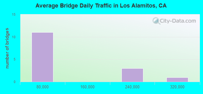
- 1,016,290Total average daily traffic
- 32,531Total average daily truck traffic
- National Bridge Inventory (NBI) Registered Bridges for Los Alamitos
- No street view available for this location
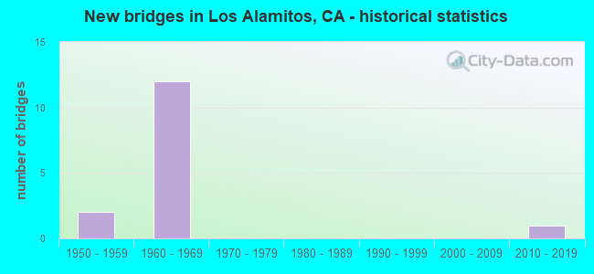
- New bridges - historical statistics
- 21950-1959
- 121960-1969
- 12010-2019
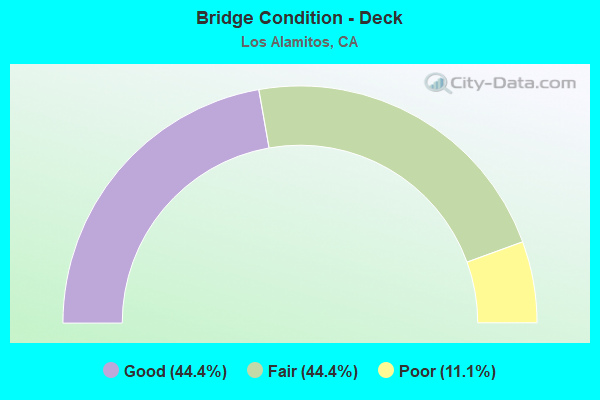
- Bridge Condition - Deck
- 44.4%Good
- 44.4%Fair
- 11.1%Poor
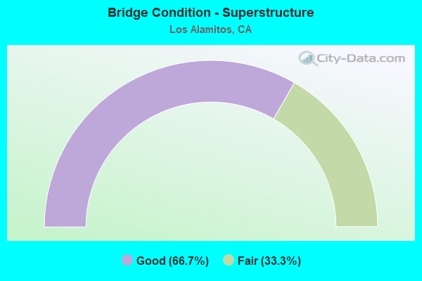
- Bridge Condition - Superstructure
- 66.7%Good
- 33.3%Fair
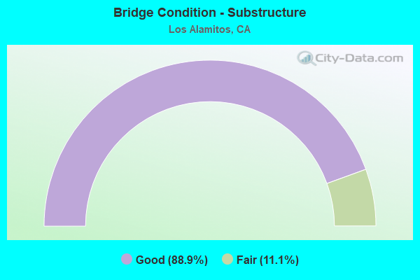
- Bridge Condition - Substructure
- 88.9%Good
- 11.1%Fair
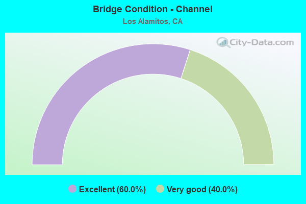
- Bridge Condition - Channel
- 60.0%Excellent
- 40.0%Very good
Find on map >> Show street view
Structure Number: 55 0347H, Location: 12-ORA-605-R0.18-LALM (Lat: 33.786992, Lng: -118.091756), Route carried "on" structure: Ramp Interstate 605, Year Built: 1966, Status: Open, Structure Length: 0.73m (2.40ft), Average Daily Traffic: 17,900 (year 2013), Truck Traffic: 3%, Average Future Daily Traffic: 21,116 (year 2038), Design Load: HS 20, Features Intersected: SERVICE RD
Minimum Vertical Clearance: 30+ m (98+ ft), Kilometerpoint: 0.180, Lanes on structure: 2, Lanes under structure: 1, Base Highway Network: Yes (Inventory Route: 6, Subroute: 1), Owner: State Highway Agency, Approaching Roadway Width: 13.7m (44.9ft), Skew: 24 degrees, Material/Design: Concrete, Design/Construction: Slab, Number Of Spans In Main Unit: 1, Length of Maximum Span: 6.7m (22.0ft), Curb-To-Curb Width: 13.7m (44.9ft), Out-to-Out Width: 13.7m (44.9ft)
Condition: Deck: Good, Superstructure: Good, Substructure: Good, Operating Rating: 54.1 metric tons, Method Used To Determine Operating Rating: Assigned rating based on Load Factor Design (LFD) reported in metric tons, Inventory Rating: 32.4 metric tons, Method Used To Determine Inventory Rating: Assigned rating based on Load Factor Design (LFD) reported in metric tons, Structural Evaluation: Better than present minimum criteria, Deck Geometry: Superior to present desirable criteria, Approach Roadway Alignment: Equal to present desirable criteria, Designated Inspection Frequency: Every 48 months, Inspection Date: September 2021
Find on map >> Show street view
Structure Number: 55 0405, Location: 12-ORA-605-R1.41-LALM (Lat: 33.802836, Lng: -118.081608), Route carried "on" structure: Interstate 605, Year Built: 1966, Status: Open, Structure Length: 6.73m (22.08ft), Average Daily Traffic: 187,000 (year 2013), Truck Traffic: 3%, Average Future Daily Traffic: 213,000 (year 2038), Design Load: HS 20, Features Intersected: KATELLA AVE
Minimum Vertical Clearance: 30+ m (98+ ft), Kilometerpoint: 1.410, Lanes on structure: 10, Lanes under structure: 5, Base Highway Network: Yes (Inventory Route: 6, Subroute: 2), Owner: State Highway Agency, Approaching Roadway Width: 45.7m (149.9ft), Skew: 1 degrees, Material/Design: Concrete continuous, Design/Construction: Box Beam or Girders - Multiple, Number Of Spans In Main Unit: 4, Length of Maximum Span: 22.3m (73.2ft), Curb-To-Curb Width: 45.7m (149.9ft), Out-to-Out Width: 46.7m (153.2ft)
Condition: Deck: Good, Superstructure: Good, Substructure: Fair, Operating Rating: 54.1 metric tons, Method Used To Determine Operating Rating: Assigned rating based on Load Factor Design (LFD) reported in metric tons, Inventory Rating: 32.4 metric tons, Method Used To Determine Inventory Rating: Assigned rating based on Load Factor Design (LFD) reported in metric tons, Structural Evaluation: Somewhat better than minimum adequacy, Deck Geometry: Superior to present desirable criteria, Underclear: Equal to present minimum criteria, Approach Roadway Alignment: Equal to present desirable criteria, Designated Inspection Frequency: Every 24 months, Inspection Date: September 2021, Deck Structure Type: Concrete Cast-file-Place
Find on map >> Show street view
Structure Number: 55 0405K, Location: 12-ORA-605-R1.41-LALM (Lat: 33.802839, Lng: -118.082167), Route carried "on" structure: Ramp Interstate 605, Year Built: 1966, Status: Open, Structure Length: 6.74m (22.11ft), Average Daily Traffic: 12,200 (year 2013), Truck Traffic: 3%, Average Future Daily Traffic: 14,391 (year 2038), Design Load: HS 20, Features Intersected: KATELLA AVE
Minimum Vertical Clearance: 30+ m (98+ ft), Kilometerpoint: 1.410, Lanes on structure: 2, Lanes under structure: 5, Owner: State Highway Agency, Approaching Roadway Width: 9.8m (32.2ft), Skew: 1 degrees, Material/Design: Concrete continuous, Design/Construction: Box Beam or Girders - Multiple, Number Of Spans In Main Unit: 4, Length of Maximum Span: 22.6m (74.1ft), Curb or Sidewalk Widths: Left: 0.6m (2.0ft), Right: 0.6m (2.0ft), Curb-To-Curb Width: 8.5m (27.9ft), Out-to-Out Width: 10.4m (34.1ft)
Condition: Deck: Fair, Superstructure: Fair, Substructure: Good, Operating Rating: 54.1 metric tons, Method Used To Determine Operating Rating: Assigned rating based on Load Factor Design (LFD) reported in metric tons, Inventory Rating: 32.4 metric tons, Method Used To Determine Inventory Rating: Assigned rating based on Load Factor Design (LFD) reported in metric tons, Structural Evaluation: Somewhat better than minimum adequacy, Deck Geometry: High priority of corrective action, Underclear: Equal to present minimum criteria, Approach Roadway Alignment: High priority of corrective action, Designated Inspection Frequency: Every 24 months, Inspection Date: September 2021, Deck Structure Type: Concrete Cast-file-Place
Find on map >> Show street view
Structure Number: 55 0405S, Location: 12-ORA-605-R1.41-LALM (Lat: 33.802836, Lng: -118.081450), Route carried "on" structure: Ramp Interstate 605, Year Built: 1966, Status: Open, Structure Length: 6.83m (22.41ft), Average Daily Traffic: 14,500 (year 2013), Truck Traffic: 3%, Average Future Daily Traffic: 17,104 (year 2038), Design Load: HS 20, Features Intersected: KATELLA AVE
Minimum Vertical Clearance: 30+ m (98+ ft), Kilometerpoint: 1.410, Lanes on structure: 1, Lanes under structure: 5, Owner: State Highway Agency, Approaching Roadway Width: 6.7m (22.0ft), Skew: 1 degrees, Material/Design: Concrete continuous, Design/Construction: Box Beam or Girders - Multiple, Number Of Spans In Main Unit: 4, Length of Maximum Span: 22.6m (74.1ft), Curb or Sidewalk Widths: Left: 0.6m (2.0ft), Right: 0.0m, Curb-To-Curb Width: 6.8m (22.3ft), Out-to-Out Width: 8.0m (26.2ft)
Condition: Deck: Fair, Superstructure: Fair, Substructure: Good, Operating Rating: 54.1 metric tons, Method Used To Determine Operating Rating: Assigned rating based on Load Factor Design (LFD) reported in metric tons, Inventory Rating: 32.4 metric tons, Method Used To Determine Inventory Rating: Assigned rating based on Load Factor Design (LFD) reported in metric tons, Structural Evaluation: Somewhat better than minimum adequacy, Deck Geometry: Equal to present minimum criteria, Underclear: Equal to present minimum criteria, Approach Roadway Alignment: Equal to present desirable criteria, Designated Inspection Frequency: Every 24 months, Inspection Date: September 2021, Deck Structure Type: Concrete Cast-file-Place, Wearing Surface/Protective System: Wearing Surface: Monolithic Concrete
Find on map >> Show street view
Structure Number: 55 0406, Location: 12-ORA-605-R1.60-LALM (Lat: 33.805850, Lng: -118.081175), Route carried "on" structure: Interstate 605, Year Built: 1966, Status: Open, Structure Length: 10.84m (35.56ft), Average Daily Traffic: 187,000 (year 2013), Truck Traffic: 3%, Average Future Daily Traffic: 216,574 (year 2038), Design Load: HS 20, Features Intersected: COYOTE CREEK
Minimum Vertical Clearance: 30+ m (98+ ft), Kilometerpoint: 1.600, Lanes on structure: 10, Base Highway Network: Yes (Inventory Route: 6, Subroute: 2), Owner: State Highway Agency, Approaching Roadway Width: 43.9m (144.0ft), Skew: 4 degrees, Material/Design: Concrete continuous, Design/Construction: Box Beam or Girders - Multiple, Number Of Spans In Main Unit: 4, Length of Maximum Span: 28.2m (92.5ft), Curb-To-Curb Width: 43.9m (144.0ft), Out-to-Out Width: 44.9m (147.3ft)
Condition: Deck: Good, Superstructure: Good, Substructure: Good, Channel: Very good, Operating Rating: 54.1 metric tons, Method Used To Determine Operating Rating: Assigned rating based on Load Factor Design (LFD) reported in metric tons, Inventory Rating: 32.4 metric tons, Method Used To Determine Inventory Rating: Assigned rating based on Load Factor Design (LFD) reported in metric tons, Structural Evaluation: Better than present minimum criteria, Deck Geometry: Better than present minimum criteria, Waterway Adequacy: Equal to present desirable criteria, Approach Roadway Alignment: Equal to present desirable criteria, Designated Inspection Frequency: Every 48 months, Inspection Date: September 2021, Deck Structure Type: Concrete Cast-file-Place, Wearing Surface/Protective System: Wearing Surface: Monolithic Concrete
Find on map >> Show street view
Structure Number: 55 0415, Location: 12-ORA-605-R0.16-LALM (Lat: 33.786139, Lng: -118.090469), Route carried "on" structure: Interstate 605, Year Built: 1966, Status: Open, Structure Length: 1.04m (3.41ft), Average Daily Traffic: 185,000 (year 2013), Truck Traffic: 5%, Average Future Daily Traffic: 213,000 (year 2038), Design Load: HS 20, Features Intersected: E22-N405 CONNECTOR RAMP
Minimum Vertical Clearance: 30+ m (98+ ft), Kilometerpoint: 0.160, Lanes on structure: 6, Lanes under structure: 1, Base Highway Network: Yes (Inventory Route: 6, Subroute: 1), Owner: State Highway Agency, Approaching Roadway Width: 32.3m (106.0ft), Skew: 2 degrees, Material/Design: Concrete, Design/Construction: Slab, Number Of Spans In Main Unit: 1, Length of Maximum Span: 10.4m (34.1ft), Curb-To-Curb Width: 32.3m (106.0ft), Out-to-Out Width: 51.8m (169.9ft)
Condition: Deck: Good, Superstructure: Good, Substructure: Good, Operating Rating: 54.1 metric tons, Method Used To Determine Operating Rating: Assigned rating based on Load Factor Design (LFD) reported in metric tons, Inventory Rating: 32.4 metric tons, Method Used To Determine Inventory Rating: Assigned rating based on Load Factor Design (LFD) reported in metric tons, Structural Evaluation: Better than present minimum criteria, Deck Geometry: Superior to present desirable criteria, Underclear: Meets minimum limits, Approach Roadway Alignment: Equal to present desirable criteria, Length Of Structure Improvement: 1.16m (3.81ft), Designated Inspection Frequency: Every 24 months, Inspection Date: September 2021
Find on map >> Show street view
Structure Number: 55 0471H, Location: 12-ORA-605-R0.19-LALM (Lat: 33.786944, Lng: -118.091925), Route carried "on" structure: Ramp Interstate 605, Year Built: 1966, Status: Open, Structure Length: 1.28m (4.20ft), Average Daily Traffic: 17,900 (year 2013), Truck Traffic: 3%, Average Future Daily Traffic: 21,116 (year 2038), Features Intersected: LOS ALAMITOS CHANNEL
Minimum Vertical Clearance: 30+ m (98+ ft), Kilometerpoint: 0.190, Lanes on structure: 2, Base Highway Network: Yes (Inventory Route: 6, Subroute: 1), Owner: State Highway Agency, Approaching Roadway Width: 13.7m (44.9ft), Skew: 4 degrees, Material/Design: Concrete, Design/Construction: Culvert, Number Of Spans In Main Unit: 3, Length of Maximum Span: 4.3m (14.1ft), Curb-To-Curb Width: 13.7m (44.9ft), Out-to-Out Width: 14.7m (48.2ft)
Condition: Channel: Very good, Culverts: Good, Operating Rating: 54.1 metric tons, Method Used To Determine Operating Rating: Field evaluation and documented engineering judgment, Inventory Rating: 32.4 metric tons, Method Used To Determine Inventory Rating: Field evaluation and documented engineering judgment, Structural Evaluation: Better than present minimum criteria, Deck Geometry: Superior to present desirable criteria, Waterway Adequacy: Equal to present desirable criteria, Approach Roadway Alignment: Equal to present desirable criteria, Designated Inspection Frequency: Every 48 months, Inspection Date: September 2021
Find on map >> Show street view
Structure Number: 55C0052, Location: 0.3 MI. N/O CERRITOS AVE. (Lat: 33.814194, Lng: -118.071728), Route carried "on" structure: City street , Year Built: 1955, Year Reconstructed: 1967, Status: Open, Structure Length: 12.98m (42.59ft), Average Daily Traffic: 24,008 (year 2014), Truck Traffic: 1%, Average Future Daily Traffic: 49,330 (year 2041), Design Load: HS 20, Features Intersected: COYOTE CREEK CHANNEL, Facility Carried by Structure: LOS ALAMITOS BLVD.
Minimum Vertical Clearance: 30+ m (98+ ft), Kilometerpoint: 0.000, Lanes on structure: 4, Base Highway Network: Yes, Owner: City or Municipal Highway Agency, Approaching Roadway Width: 23.8m (78.1ft), Skew: 5 degrees, Material/Design: Steel, Design/Construction: Stringer/Multi-beam, Number Of Spans In Main Unit: 6, Length of Maximum Span: 25.3m (83.0ft), Curb or Sidewalk Widths: Left: 0.0m, Right: 1.4m (4.6ft), Curb-To-Curb Width: 16.5m (54.1ft), Out-to-Out Width: 18.3m (60.0ft)
Condition: Deck: Poor, Superstructure: Good, Substructure: Good, Channel: Excellent, Operating Rating: 56.4 metric tons, Method Used To Determine Operating Rating: Load Factor (LF), Inventory Rating: 33.7 metric tons, Method Used To Determine Inventory Rating: Load Factor (LF), Structural Evaluation: Better than present minimum criteria, Deck Geometry: Meets minimum limits, Waterway Adequacy: Superior to present desirable criteria, Approach Roadway Alignment: Equal to present desirable criteria, Length Of Structure Improvement: 12.98m (42.59ft), Designated Inspection Frequency: Every 24 months, Inspection Date: Febuary 2021, Bridge Improvement Cost: $2,375,000, Roadway Improvement Cost: $475,000, Total Project Cost: $3,990,000 ( Estimate for 2020), Deck Structure Type: Concrete Cast-file-Place
Find on map >> Show street view
Structure Number: 55C0264L, Location: 0.2 MI W/O LOS ALAMITOS (Lat: 33.810475, Lng: -118.076253), Route carried "on" structure: City street , Year Built: 1962, Status: Open, Structure Length: 9.63m (31.59ft), Average Daily Traffic: 29,391 (year 2014), Truck Traffic: 1%, Average Future Daily Traffic: 34,431 (year 2041), Design Load: HS 20, Features Intersected: COYOTE CREEK CHANNEL, Facility Carried by Structure: WB CERRITOS AVE
Minimum Vertical Clearance: 30+ m (98+ ft), Kilometerpoint: 0.000, Lanes on structure: 2, Owner: City or Municipal Highway Agency, Approaching Roadway Width: 9.8m (32.2ft), Skew: 4 degrees, Material/Design: Steel, Design/Construction: Stringer/Multi-beam, Number Of Spans In Main Unit: 4, Length of Maximum Span: 24.1m (79.1ft), Curb-To-Curb Width: 9.0m (29.5ft), Out-to-Out Width: 9.1m (29.9ft)
Condition: Deck: Fair, Superstructure: Good, Substructure: Good, Channel: Excellent, Operating Rating: 71.9 metric tons, Method Used To Determine Operating Rating: Load Factor (LF), Inventory Rating: 43.1 metric tons, Method Used To Determine Inventory Rating: Load Factor (LF), Structural Evaluation: Better than present minimum criteria, Deck Geometry: High priority of corrective action, Waterway Adequacy: Superior to present desirable criteria, Approach Roadway Alignment: Equal to present desirable criteria, Designated Inspection Frequency: Every 24 months, Other Special Inspection Frequency: Every 48 months, Inspection Date: Febuary 2021, Other Special Inspection Date: July 2021, Deck Structure Type: Concrete Cast-file-Place
Find on map >> Show street view
Structure Number: 55C0264R, Location: 0.2 MI. W/O LOS ALAMITOS (Lat: 33.810314, Lng: -118.076389), Route carried "on" structure: City street , Year Built: 1956, Status: Open, Structure Length: 9.69m (31.79ft), Average Daily Traffic: 29,391 (year 2014), Truck Traffic: 1%, Average Future Daily Traffic: 34,431 (year 2041), Design Load: HS 20, Features Intersected: COYOTE CREEK CHANNEL, Facility Carried by Structure: EB CERRITOS AVE
Minimum Vertical Clearance: 30+ m (98+ ft), Kilometerpoint: 0.000, Lanes on structure: 2, Owner: City or Municipal Highway Agency, Approaching Roadway Width: 7.8m (25.6ft), Skew: 4 degrees, Material/Design: Steel, Design/Construction: Stringer/Multi-beam, Number Of Spans In Main Unit: 4, Length of Maximum Span: 24.1m (79.1ft), Curb or Sidewalk Widths: Left: 1.4m (4.6ft), Right: 1.4m (4.6ft), Curb-To-Curb Width: 7.8m (25.6ft), Out-to-Out Width: 11.3m (37.1ft)
Condition: Deck: Fair, Superstructure: Fair, Substructure: Good, Channel: Excellent, Operating Rating: 59.6 metric tons, Method Used To Determine Operating Rating: Load Factor (LF), Inventory Rating: 35.6 metric tons, Method Used To Determine Inventory Rating: Load Factor (LF), Structural Evaluation: Somewhat better than minimum adequacy, Deck Geometry: High priority of replacement, Waterway Adequacy: Superior to present desirable criteria, Approach Roadway Alignment: Equal to present desirable criteria, Designated Inspection Frequency: Every 24 months, Inspection Date: Febuary 2021, Deck Structure Type: Concrete Cast-file-Place
Find on map >> Show street view
Structure Number: 55 0405, Location: 12-ORA-605-R1.41-LALM (Lat: 33.802836, Lng: -118.081608), Route carried "under" structure: City street L030, Year Built: 1966, Structure Length: 0. m, Average Daily Traffic: 15,000 (year 2013), Truck Traffic: 3%, Features Intersected: KATELLA AVE, Facility Carried by Structure: INTERSTATE 605
Minimum Vertical Clearance: 4.77m (15.65ft), Kilometerpoint: 0.000, Lanes on structure: 10, Lanes under structure: 5, Material/Design: Concrete continuous, Design/Construction: Box Beam or Girders - Multiple, Length of Maximum Span: 22.3m (73.2ft)
Find on map >> Show street view
Structure Number: 55 0405K, Location: 12-ORA-605-R1.41-LALM (Lat: 33.802839, Lng: -118.082167), Route carried "under" structure: City street , Year Built: 1966, Structure Length: 0. m, Average Daily Traffic: 15,000 (year 2013), Truck Traffic: 3%, Features Intersected: KATELLA AVE, Facility Carried by Structure: S605-KATELLA OFF R
Minimum Vertical Clearance: 4.67m (15.32ft), Kilometerpoint: 0.000, Lanes on structure: 2, Lanes under structure: 5, Material/Design: Concrete continuous, Design/Construction: Box Beam or Girders - Multiple, Length of Maximum Span: 22.6m (74.1ft)
Find on map >> Show street view
Structure Number: 55 0405S, Location: 12-ORA-605-R1.41-LALM (Lat: 33.802836, Lng: -118.081450), Route carried "under" structure: City street , Year Built: 1966, Structure Length: 0. m, Average Daily Traffic: 15,000 (year 2013), Truck Traffic: 3%, Features Intersected: KATELLA AVE, Facility Carried by Structure: N605-KATELLA OFF R
Minimum Vertical Clearance: 4.67m (15.32ft), Kilometerpoint: 0.000, Lanes on structure: 1, Lanes under structure: 5, Material/Design: Concrete continuous, Design/Construction: Box Beam or Girders - Multiple, Length of Maximum Span: 22.6m (74.1ft)
Find on map >> Show street view
Structure Number: 55 0415, Location: 12-ORA-605-R0.16-LALM (Lat: 33.786139, Lng: -118.090469), Route carried "under" structure: Ramp State highway 22, Year Built: 1966, Structure Length: 0. m, Average Daily Traffic: 12,000 (year 2013), Truck Traffic: 3%, Features Intersected: E22-N405 CONNECTOR RAMP, Facility Carried by Structure: INTERSTATE 605
Minimum Vertical Clearance: 4.77m (15.65ft), Kilometerpoint: 0.600, Lanes on structure: 6, Lanes under structure: 1, Material/Design: Concrete, Design/Construction: Slab, Length of Maximum Span: 10.4m (34.1ft)
Find on map >> Show street view
Structure Number: 55 1100G, Location: 12-ORA-405-23.30-LALM (Lat: 33.774608, Lng: -118.086747), Route carried "under" structure: Interstate 405, Year Built: 2012, Structure Length: 0. m, Average Daily Traffic: 255,000 (year 2013), Truck Traffic: 3%, Features Intersected: INTERSTATE 405
Minimum Vertical Clearance: 6.50m (21.33ft), Kilometerpoint: 23.320, Lanes on structure: 2, Lanes under structure: 14, Material/Design: Prestressed concrete continuous, Design/Construction: Box Beam or Girders - Multiple, Length of Maximum Span: 81.5m (267.4ft)