Bridge Statistics for Loomis, Michigan (MI)
Condition, Traffic, Stress, Structural Evaluation, Project Costs
- National Bridge Inventory (NBI) Statistics
- 20Number of bridges
- 115ft / 34.9mTotal length
- $758,000Total costs
- 24,400Total average daily traffic
- 1,915Total average daily truck traffic
- National Bridge Inventory (NBI) Registered Bridges for Loomis
- No street view available for this location
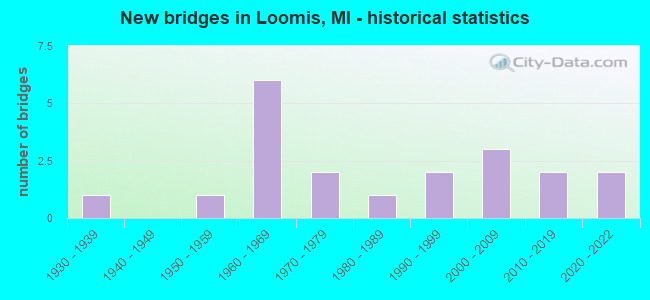
- New bridges - historical statistics
- 11930-1939
- 11950-1959
- 61960-1969
- 21970-1979
- 11980-1989
- 21990-1999
- 32000-2009
- 22010-2019
- 22020-2022


- Bridge Condition - Deck
- 27.3%Very good
- 27.3%Good
- 36.4%Satisfactory
- 9.1%Fair

- Bridge Condition - Superstructure
- 45.5%Very good
- 18.2%Good
- 27.3%Fair
- 9.1%Poor

- Bridge Condition - Substructure
- 45.5%Very good
- 18.2%Good
- 18.2%Satisfactory
- 18.2%Poor

- Bridge Condition - Channel
- 31.3%Very good
- 25.0%Good
- 37.5%Satisfactory
- 6.3%Serious

- Bridge Condition - Culverts
- 14.3%Very good
- 28.6%Good
- 14.3%Satisfactory
- 14.3%Fair
- 14.3%Poor
- 14.3%Serious
Find on map >> Show street view
Structure Number: 1734, Location: SHERIDAN TWP SEC 22, 27 (Lat: 43.844128, Lng: -84.661508), Route carried "on" structure: County highway , Year Built: 1998, Status: Open, Structure Length: 2.00m (6.56ft), Average Daily Traffic: 600 (year 2006), Truck Traffic: 3%, Average Future Daily Traffic: 1,100 (year 2026), Design Load: HS 20, Features Intersected: S BR TOBACCO RIVER, Facility Carried by Structure: COLONVILLE ROAD
Minimum Vertical Clearance: 30.48m (100.00ft), Kilometerpoint: 8.576, Lanes on structure: 2, Owner: County Highway Agency, Approaching Roadway Width: 8.5m (27.9ft), Skew: 1 degrees, Material/Design: Concrete, Number Of Spans In Main Unit: 1, Length of Maximum Span: 18.8m (61.7ft), Curb-To-Curb Width: 9.8m (32.2ft), Out-to-Out Width: 10.5m (34.4ft)
Condition: Deck: Satisfactory, Superstructure: Very good, Substructure: Very good, Channel: Very good, Operating Rating: 77.8 metric tons, Method Used To Determine Operating Rating: Load Factor (LF) rating reported by rating factor (RF) method using MS18 loading, Inventory Rating: 43.4 metric tons, Method Used To Determine Inventory Rating: Load Factor (LF) rating reported by rating factor (RF) method using MS18 loading, Structural Evaluation: Equal to present desirable criteria, Deck Geometry: Equal to present minimum criteria, Waterway Adequacy: Superior to present desirable criteria, Approach Roadway Alignment: Superior to present desirable criteria, Designated Inspection Frequency: Every 24 months, Inspection Date: August 2020, Bridge Improvement Cost: $260,000, Roadway Improvement Cost: $75,000, Total Project Cost: $335,000, Deck Structure Type: Concrete Precast Panels, Wearing Surface/Protective System: Wearing Surface: Monolithic Concrete, Deck Protection: Epoxy Coated Reinforcing
Find on map >> Show street view
Structure Number: 1742, Location: SHERIDAN TWP SEC 22 (Lat: 43.845164, Lng: -84.654422), Route carried "on" structure: County highway 1889, Year Built: 1959, Status: Open, Structure Length: 1.46m (4.79ft), Average Daily Traffic: 800 (year 2006), Average Future Daily Traffic: 1,430 (year 2026), Design Load: HS 20+Mod, Features Intersected: S BR TOBACCO RIVER, Facility Carried by Structure: TOBACCO DRIVE
Minimum Vertical Clearance: 30.48m (100.00ft), Kilometerpoint: 3.563, Lanes on structure: 2, Owner: County Highway Agency, Approaching Roadway Width: 8.5m (27.9ft), Material/Design: Steel, Design/Construction: Culvert, Number Of Spans In Main Unit: 3, Length of Maximum Span: 3.9m (12.8ft)
Condition: Channel: Satisfactory, Culverts: Satisfactory, Operating Rating: 77.4 metric tons, Method Used To Determine Operating Rating: Load Factor (LF) rating reported by rating factor (RF) method using MS18 loading, Inventory Rating: 46.3 metric tons, Method Used To Determine Inventory Rating: Load Factor (LF) rating reported by rating factor (RF) method using MS18 loading, Structural Evaluation: Equal to present minimum criteria, Waterway Adequacy: Equal to present desirable criteria, Approach Roadway Alignment: Equal to present minimum criteria, Designated Inspection Frequency: Every 24 months, Inspection Date: August 2020, Wearing Surface/Protective System: Wearing Surface: Bituminous
Find on map >> Show street view
Structure Number: 1771, Location: SEC 28-29 SHERIDAN TWP (Lat: 43.829339, Lng: -84.686875), Route carried "on" structure: ServiceCounty highway , Year Built: 1979, Status: Open, Structure Length: 2.43m (7.97ft), Average Daily Traffic: 290 (year 2006), Average Future Daily Traffic: 520 (year 2026), Design Load: HS 20+Mod, Features Intersected: S BR TOBACCO RIVER, Facility Carried by Structure: BRAND AVENUE
Minimum Vertical Clearance: 30.48m (100.00ft), Kilometerpoint: 1.580, Lanes on structure: 2, Owner: County Highway Agency, Approaching Roadway Width: 6.7m (22.0ft), Material/Design: Prestressed concrete, Design/Construction: Box Beam or Girders - Multiple, Number Of Spans In Main Unit: 2, Length of Maximum Span: 12.2m (40.0ft), Curb-To-Curb Width: 9.1m (29.9ft), Out-to-Out Width: 9.2m (30.2ft)
Condition: Deck: Good, Superstructure: Good, Substructure: Satisfactory, Channel: Satisfactory, Operating Rating: 65.1 metric tons, Method Used To Determine Operating Rating: Load Factor (LF) rating reported by rating factor (RF) method using MS18 loading, Inventory Rating: 38.9 metric tons, Method Used To Determine Inventory Rating: Load Factor (LF) rating reported by rating factor (RF) method using MS18 loading, Structural Evaluation: Equal to present minimum criteria, Deck Geometry: Equal to present minimum criteria, Waterway Adequacy: Better than present minimum criteria, Approach Roadway Alignment: Equal to present desirable criteria, Designated Inspection Frequency: Every 24 months, Inspection Date: August 2020, Deck Structure Type: Concrete Cast-file-Place, Wearing Surface/Protective System: Wearing Surface: Bituminous
Find on map >> Show street view
Structure Number: 3007, Location: SEC 33-34 ERWIN TWP (Lat: 46.344097, Lng: -90.052736), Route carried "on" structure: County highway , Year Built: 1994, Status: Open, Structure Length: 0.85m (2.79ft), Average Daily Traffic: 3 (year 1998), Design Load: HS 20, Features Intersected: BLACK RIVER, Facility Carried by Structure: KETOLA GRADE ROAD
Minimum Vertical Clearance: 30.48m (100.00ft), Kilometerpoint: 4.944, Lanes on structure: 1, Owner: County Highway Agency, Approaching Roadway Width: 3.7m (12.1ft), Material/Design: Steel, Design/Construction: Stringer/Multi-beam, Number Of Spans In Main Unit: 1, Length of Maximum Span: 7.3m (24.0ft), Curb-To-Curb Width: 3.7m (12.1ft), Out-to-Out Width: 4.3m (14.1ft)
Condition: Deck: Satisfactory, Superstructure: Fair, Substructure: Poor, Channel: Good, Operating Rating: 97.2 metric tons, Method Used To Determine Operating Rating: Load Factor (LF) rating reported by rating factor (RF) method using MS18 loading, Inventory Rating: 66.7 metric tons, Method Used To Determine Inventory Rating: Load Factor (LF) rating reported by rating factor (RF) method using MS18 loading, Structural Evaluation: Meets minimum limits, Deck Geometry: Meets minimum limits, Waterway Adequacy: Somewhat better than minimum adequacy, Approach Roadway Alignment: Meets minimum limits, Length Of Structure Improvement: 0.95m (3.12ft), Designated Inspection Frequency: Every 24 months, Inspection Date: September 2020, Bridge Improvement Cost: $133,000, Roadway Improvement Cost: $13,000, Total Project Cost: $183,000, Deck Structure Type: Wood or Timber, Wearing Surface/Protective System: Wearing Surface: Wood or Timber
Find on map >> Show street view
Structure Number: 427, Location: 3.4 MI NW OF MIDLAND COL (Lat: 43.799053, Lng: -84.666825), Route carried "on" structure: County highway 3787, Year Built: 1962, Year Reconstructed: 2006, Status: Open, Structure Length: 7.14m (23.43ft), Average Daily Traffic: 470 (year 1974), Truck Traffic: 3%, Average Future Daily Traffic: 470 (year 1977), Design Load: HS 20+Mod, Features Intersected: US-10, Facility Carried by Structure: LOOMIS RD
Minimum Vertical Clearance: 30.48m (100.00ft), Kilometerpoint: 11.127, Lanes on structure: 2, Lanes under structure: 4, Owner: State Highway Agency, Approaching Roadway Width: 10.9m (35.8ft), Skew: 2 degrees, Material/Design: Steel, Design/Construction: Stringer/Multi-beam, Number Of Spans In Main Unit: 4, Length of Maximum Span: 24.4m (80.1ft), Curb-To-Curb Width: 9.0m (29.5ft), Out-to-Out Width: 10.0m (32.8ft)
Condition: Deck: Good, Superstructure: Good, Substructure: Good, Operating Rating: 94.0 metric tons, Method Used To Determine Operating Rating: Load Factor (LF) rating reported by rating factor (RF) method using MS18 loading, Inventory Rating: 56.4 metric tons, Method Used To Determine Inventory Rating: Load Factor (LF) rating reported by rating factor (RF) method using MS18 loading, Structural Evaluation: Better than present minimum criteria, Deck Geometry: Somewhat better than minimum adequacy, Underclear: Somewhat better than minimum adequacy, Approach Roadway Alignment: Equal to present minimum criteria, Designated Inspection Frequency: Every 24 months, Inspection Date: March 2021, Deck Structure Type: Concrete Cast-file-Place, Wearing Surface/Protective System: Wearing Surface: Latex Concrete
Find on map >> Show street view
Structure Number: 4271, Location: 2.2 MI SE OF CLARE COL (Lat: 43.808078, Lng: -84.707206), Route carried "on" structure: County highway 3779, Year Built: 1961, Status: Open, Structure Length: 7.46m (24.48ft), Average Daily Traffic: 110 (year 1977), Truck Traffic: 3%, Average Future Daily Traffic: 110 (year 1977), Design Load: H 15, Features Intersected: US-10, Facility Carried by Structure: LEATON RD
Minimum Vertical Clearance: 30.48m (100.00ft), Kilometerpoint: 28.485, Lanes on structure: 2, Lanes under structure: 4, Owner: State Highway Agency, Approaching Roadway Width: 10.1m (33.1ft), Material/Design: Prestressed concrete, Design/Construction: Stringer/Multi-beam, Number Of Spans In Main Unit: 4, Length of Maximum Span: 21.1m (69.2ft), Curb-To-Curb Width: 8.4m (27.6ft), Out-to-Out Width: 9.4m (30.8ft)
Condition: Deck: Satisfactory, Superstructure: Fair, Substructure: Satisfactory, Operating Rating: 51.5 metric tons, Method Used To Determine Operating Rating: Load Factor (LF) rating reported by rating factor (RF) method using MS18 loading, Inventory Rating: 28.2 metric tons, Method Used To Determine Inventory Rating: Load Factor (LF) rating reported by rating factor (RF) method using MS18 loading, Structural Evaluation: Somewhat better than minimum adequacy, Deck Geometry: Somewhat better than minimum adequacy, Underclear: Somewhat better than minimum adequacy, Approach Roadway Alignment: Somewhat better than minimum adequacy, Designated Inspection Frequency: Every 24 months, Inspection Date: June 2020, Deck Structure Type: Concrete Cast-file-Place, Wearing Surface/Protective System: Wearing Surface: Epoxy Overlay
Find on map >> Show street view
Structure Number: 4292, Location: 0.2M W SE COR SEC 33 T16N (Lat: 43.728250, Lng: -84.670761), Route carried "on" structure: County highway , Year Built: 1980, Status: Open, Structure Length: 1.82m (5.97ft), Average Daily Traffic: 93 (year 2002), Average Future Daily Traffic: 140 (year 2022), Design Load: H 20, Features Intersected: NORTH BR SALT RIVER, Facility Carried by Structure: VERNON ROAD
Minimum Vertical Clearance: 30.48m (100.00ft), Kilometerpoint: 33.550, Lanes on structure: 2, Owner: County Highway Agency, Approaching Roadway Width: 9.1m (29.9ft), Material/Design: Prestressed concrete, Design/Construction: Box Beam or Girders - Multiple, Number Of Spans In Main Unit: 1, Length of Maximum Span: 17.0m (55.8ft), Curb-To-Curb Width: 9.4m (30.8ft), Out-to-Out Width: 9.4m (30.8ft)
Condition: Deck: Satisfactory, Superstructure: Fair, Substructure: Good, Channel: Satisfactory, Operating Rating: 48.0 metric tons, Method Used To Determine Operating Rating: Load Factor (LF), Inventory Rating: 28.8 metric tons, Method Used To Determine Inventory Rating: Load Factor (LF), Structural Evaluation: Somewhat better than minimum adequacy, Deck Geometry: Better than present minimum criteria, Waterway Adequacy: Better than present minimum criteria, Approach Roadway Alignment: Equal to present minimum criteria, Designated Inspection Frequency: Every 24 months, Inspection Date: May 2020, Deck Structure Type: Concrete Precast Panels, Wearing Surface/Protective System: Wearing Surface: Bituminous, Membrane: Other
Find on map >> Show street view
Structure Number: 4293, Location: 100 FT E NW SEC 29 T16N R (Lat: 43.757094, Lng: -84.706792), Route carried "on" structure: County highway 3782, Year Built: 2013, Status: Open, Structure Length: 1.37m (4.49ft), Average Daily Traffic: 693 (year 2009), Truck Traffic: 4%, Average Future Daily Traffic: 934 (year 2029), Design Load: Greater than HL93, Features Intersected: MCDONALD DRAIN, Facility Carried by Structure: COLEMAN ROAD
Minimum Vertical Clearance: 30.48m (100.00ft), Kilometerpoint: 4.902, Lanes on structure: 2, Owner: County Highway Agency, Approaching Roadway Width: 9.3m (30.5ft), Material/Design: Prestressed concrete, Design/Construction: Box Beam or Girders - Multiple, Number Of Spans In Main Unit: 1, Length of Maximum Span: 13.3m (43.6ft), Curb-To-Curb Width: 9.7m (31.8ft), Out-to-Out Width: 10.7m (35.1ft)
Condition: Deck: Good, Superstructure: Very good, Substructure: Very good, Channel: Good, Operating Rating: 71.9 metric tons, Method Used To Determine Operating Rating: Load and Resistance Factor Rating (LRFR) rating reported by rating factor(RF) method using HL-93 loadings, Inventory Rating: 54.8 metric tons, Method Used To Determine Inventory Rating: Load and Resistance Factor Rating (LRFR) rating reported by rating factor(RF) method using HL-93 loadings, Structural Evaluation: Equal to present desirable criteria, Deck Geometry: Equal to present minimum criteria, Waterway Adequacy: Better than present minimum criteria, Approach Roadway Alignment: Equal to present minimum criteria, Designated Inspection Frequency: Every 24 months, Inspection Date: May 2020, Deck Structure Type: Concrete Cast-file-Place, Wearing Surface/Protective System: Wearing Surface: Monolithic Concrete, Deck Protection: Epoxy Coated Reinforcing
Find on map >> Show street view
Structure Number: 4315, Location: 0.1 M S NE COR SEC 28 T16 (Lat: 43.756161, Lng: -84.667150), Route carried "on" structure: County highway , Year Built: 2010, Status: Open, Structure Length: 1.37m (4.49ft), Average Daily Traffic: 654 (year 2009), Truck Traffic: 4%, Average Future Daily Traffic: 881 (year 2029), Design Load: HS 20, Features Intersected: LOOMIS DRAIN, Facility Carried by Structure: LOOMIS ROAD
Minimum Vertical Clearance: 30.48m (100.00ft), Kilometerpoint: 6.364, Lanes on structure: 2, Owner: County Highway Agency, Approaching Roadway Width: 9.1m (29.9ft), Material/Design: Prestressed concrete, Design/Construction: Box Beam or Girders - Multiple, Number Of Spans In Main Unit: 1, Length of Maximum Span: 13.3m (43.6ft), Curb-To-Curb Width: 9.7m (31.8ft), Out-to-Out Width: 10.6m (34.8ft)
Condition: Deck: Very good, Superstructure: Very good, Substructure: Very good, Channel: Very good, Inventory Rating: 64.7 metric tons, Method Used To Determine Inventory Rating: Load Factor (LF), Structural Evaluation: Equal to present desirable criteria, Deck Geometry: Equal to present minimum criteria, Waterway Adequacy: Equal to present desirable criteria, Approach Roadway Alignment: Equal to present minimum criteria, Designated Inspection Frequency: Every 24 months, Inspection Date: June 2020, Deck Structure Type: Concrete Cast-file-Place, Wearing Surface/Protective System: Wearing Surface: Monolithic Concrete, Deck Protection: Epoxy Coated Reinforcing
Find on map >> Show street view
Structure Number: 4352, Location: SEC 4-9 DENVER TWP (Lat: 43.713439, Lng: -84.673153), Route carried "on" structure: ServiceCounty highway , Year Built: 1937, Status: Posted for load, Structure Length: 1.67m (5.48ft), Average Daily Traffic: 185 (year 2002), Average Future Daily Traffic: 225 (year 2022), Design Load: H 15, Features Intersected: NORTH BR SALT RIVER, Facility Carried by Structure: DENVER ROAD
Minimum Vertical Clearance: 30.48m (100.00ft), Kilometerpoint: 6.026, Lanes on structure: 2, Owner: County Highway Agency, Approaching Roadway Width: 8.5m (27.9ft), Material/Design: Steel, Design/Construction: Stringer/Multi-beam, Number Of Spans In Main Unit: 1, Length of Maximum Span: 15.5m (50.9ft), Curb-To-Curb Width: 6.1m (20.0ft), Out-to-Out Width: 6.7m (22.0ft)
Condition: Deck: Fair, Superstructure: Poor, Substructure: Poor, Channel: Serious, Operating Rating: 25.1 metric tons, Method Used To Determine Operating Rating: Load Factor (LF), Inventory Rating: 15.1 metric tons, Method Used To Determine Inventory Rating: Load Factor (LF), Structural Evaluation: Meets minimum limits, Deck Geometry: Meets minimum limits, Waterway Adequacy: Meets minimum limits, Approach Roadway Alignment: Equal to present minimum criteria, Bridge Posting: Required (Relationship of Operating Rating to Maximum Legal Load: 30.0 - 39.9% below), Length Of Structure Improvement: 2.38m (7.81ft), Designated Inspection Frequency: Every 12 months, Inspection Date: April 2021, Bridge Improvement Cost: $160,000, Roadway Improvement Cost: $16,000, Total Project Cost: $240,000, Deck Structure Type: Other, Wearing Surface/Protective System: Wearing Surface: Monolithic Concrete
Find on map >> Show street view
Structure Number: 13238, Location: WISE TWP SEC 19-20 (Lat: 43.760644, Lng: -84.707411), Route carried "on" structure: County highway , Year Built: 2003, Status: Open, Structure Length: 0.66m (2.17ft), Average Daily Traffic: 500 (year 2004), Average Future Daily Traffic: 903 (year 2024), Design Load: HS 20, Features Intersected: MCDONALD DRAIN, Facility Carried by Structure: LEATON ROAD
Minimum Vertical Clearance: 30.48m (100.00ft), Kilometerpoint: 23.216, Lanes on structure: 2, Owner: County Highway Agency, Approaching Roadway Width: 9.8m (32.2ft), Skew: 2 degrees, Material/Design: Concrete, Design/Construction: Culvert, Number Of Spans In Main Unit: 1, Length of Maximum Span: 6.6m (21.7ft), Curb-To-Curb Width: 9.8m (32.2ft), Out-to-Out Width: 19.5m (64.0ft)
Condition: Channel: Good, Culverts: Good, Operating Rating: 43.6 metric tons, Method Used To Determine Operating Rating: Field evaluation and documented engineering judgment, Inventory Rating: 32.7 metric tons, Method Used To Determine Inventory Rating: Field evaluation and documented engineering judgment, Structural Evaluation: Better than present minimum criteria, Deck Geometry: Equal to present minimum criteria, Waterway Adequacy: Equal to present desirable criteria, Approach Roadway Alignment: Equal to present desirable criteria, Designated Inspection Frequency: Every 24 months, Inspection Date: June 2020, Wearing Surface/Protective System: Wearing Surface: Bituminous
Find on map >> Show street view
Structure Number: 13394, Location: WISE TWP SEC 22 (Lat: 43.757139, Lng: -84.661667), Route carried "on" structure: County highway , Year Built: 2005, Status: Open, Structure Length: 0.71m (2.33ft), Average Daily Traffic: 828 (year 2007), Average Future Daily Traffic: 1,495 (year 2027), Design Load: HS 20, Features Intersected: CURTIS DRAIN, Facility Carried by Structure: COLEMAN ROAD
Minimum Vertical Clearance: 30.48m (100.00ft), Kilometerpoint: 8.536, Lanes on structure: 2, Owner: County Highway Agency, Approaching Roadway Width: 9.1m (29.9ft), Skew: 1 degrees, Material/Design: Concrete, Design/Construction: Culvert, Number Of Spans In Main Unit: 1, Length of Maximum Span: 6.5m (21.3ft), Curb-To-Curb Width: 9.1m (29.9ft), Out-to-Out Width: 19.5m (64.0ft)
Condition: Channel: Very good, Culverts: Good, Operating Rating: 43.6 metric tons, Method Used To Determine Operating Rating: Field evaluation and documented engineering judgment, Inventory Rating: 32.7 metric tons, Method Used To Determine Inventory Rating: Field evaluation and documented engineering judgment, Structural Evaluation: Better than present minimum criteria, Deck Geometry: Equal to present minimum criteria, Waterway Adequacy: Equal to present desirable criteria, Approach Roadway Alignment: Equal to present desirable criteria, Designated Inspection Frequency: Every 24 months, Inspection Date: May 2021, Wearing Surface/Protective System: Wearing Surface: Bituminous
Find on map >> Show street view
Structure Number: 14006, Location: 650 FT E LOOMIS ROAD (Lat: 43.742722, Lng: -84.664694), Route carried "on" structure: County highway , Year Built: 2021, Status: Open, Structure Length: 1.52m (4.99ft), Average Daily Traffic: 50 (year 2017), Average Future Daily Traffic: 100 (year 2037), Design Load: Greater than HL93, Features Intersected: N BR SALT RIVER, Facility Carried by Structure: BATTLE ROAD
Minimum Vertical Clearance: 30.48m (100.00ft), Kilometerpoint: 6.689, Lanes on structure: 2, Owner: County Highway Agency, Approaching Roadway Width: 6.1m (20.0ft), Material/Design: Prestressed concrete, Design/Construction: Box Beam or Girders - Single/Spread, Number Of Spans In Main Unit: 1, Length of Maximum Span: 14.8m (48.6ft), Curb-To-Curb Width: 9.1m (29.9ft), Out-to-Out Width: 10.0m (32.8ft)
Condition: Deck: Very good, Superstructure: Very good, Substructure: Very good, Channel: Very good, Operating Rating: 52.2 metric tons, Method Used To Determine Operating Rating: Load and Resistance Factor Rating (LRFR) rating reported by rating factor(RF) method using HL-93 loadings, Inventory Rating: 29.5 metric tons, Method Used To Determine Inventory Rating: Load and Resistance Factor Rating (LRFR) rating reported by rating factor(RF) method using HL-93 loadings, Structural Evaluation: Better than present minimum criteria, Deck Geometry: Better than present minimum criteria, Waterway Adequacy: Equal to present desirable criteria, Approach Roadway Alignment: Equal to present desirable criteria, Designated Inspection Frequency: Every 24 months, Inspection Date: July 2021, Deck Structure Type: Concrete Cast-file-Place, Wearing Surface/Protective System: Wearing Surface: Monolithic Concrete, Deck Protection: Epoxy Coated Reinforcing
Find on map >> Show street view
Structure Number: 14166, Location: 900 FT S OF BATTLE RD (Lat: 43.740400, Lng: -84.667200), Route carried "on" structure: County highway , Year Built: 2021, Status: Open, Structure Length: 1.52m (4.99ft), Average Daily Traffic: 423 (year 2016), Average Future Daily Traffic: 516 (year 2036), Design Load: Greater than HL93, Features Intersected: N BR SALT RIVER, Facility Carried by Structure: LOOMIS RD
Minimum Vertical Clearance: 30.48m (100.00ft), Kilometerpoint: 0.000, Lanes on structure: 2, Owner: County Highway Agency, Approaching Roadway Width: 6.7m (22.0ft), Material/Design: Prestressed concrete, Design/Construction: Box Beam or Girders - Single/Spread, Number Of Spans In Main Unit: 1, Length of Maximum Span: 14.8m (48.6ft), Curb-To-Curb Width: 9.8m (32.2ft), Out-to-Out Width: 10.6m (34.8ft)
Condition: Deck: Very good, Superstructure: Very good, Substructure: Very good, Channel: Very good, Operating Rating: 67.7 metric tons, Method Used To Determine Operating Rating: Load and Resistance Factor Rating (LRFR) rating reported by rating factor(RF) method using HL-93 loadings, Inventory Rating: 44.4 metric tons, Method Used To Determine Inventory Rating: Load and Resistance Factor Rating (LRFR) rating reported by rating factor(RF) method using HL-93 loadings, Structural Evaluation: Equal to present desirable criteria, Deck Geometry: Equal to present minimum criteria, Waterway Adequacy: Equal to present desirable criteria, Approach Roadway Alignment: Equal to present desirable criteria, Designated Inspection Frequency: Every 24 months, Inspection Date: July 2021, Deck Structure Type: Concrete Cast-file-Place, Wearing Surface/Protective System: Wearing Surface: Monolithic Concrete, Deck Protection: Epoxy Coated Reinforcing
Find on map >> Show street view
Structure Number: 144, Location: 600' W OF LOOMIS RD (Lat: 43.757200, Lng: -84.669500), Route carried "on" structure: County highway 3782, Year Built: 2009, Status: Open, Structure Length: 0.79m (2.59ft), Average Daily Traffic: 1,145 (year 2010), Truck Traffic: 2%, Average Future Daily Traffic: 1,234 (year 2030), Features Intersected: LOOMIS DRAIN, Facility Carried by Structure: COLEMAN RD
Minimum Vertical Clearance: 30.48m (100.00ft), Kilometerpoint: 7.906, Lanes on structure: 2, Owner: County Highway Agency, Approaching Roadway Width: 9.8m (32.2ft), Material/Design: Concrete, Design/Construction: Culvert, Number Of Spans In Main Unit: 1, Length of Maximum Span: 7.9m (25.9ft)
Condition: Channel: Good, Culverts: Very good, Operating Rating: 54.5 metric tons, Method Used To Determine Operating Rating: Field evaluation and documented engineering judgment, Inventory Rating: 32.7 metric tons, Method Used To Determine Inventory Rating: Field evaluation and documented engineering judgment, Structural Evaluation: Equal to present desirable criteria, Waterway Adequacy: Equal to present desirable criteria, Approach Roadway Alignment: Equal to present desirable criteria, Designated Inspection Frequency: Every 24 months, Inspection Date: April 2021, Wearing Surface/Protective System: Wearing Surface: Bituminous
Find on map >> Show street view
Structure Number: 14401, Location: 0.2 MI W OF LOOMIS RD (Lat: 43.742700, Lng: -84.671200), Route carried "on" structure: County highway , Year Built: 1970, Status: Open, Structure Length: 0.76m (2.49ft), Average Daily Traffic: 80 (year 2021), Truck Traffic: 2%, Average Future Daily Traffic: 92 (year 2041), Features Intersected: MCDONALD DRAIN, Facility Carried by Structure: BATTLE RD
Minimum Vertical Clearance: 30.48m (100.00ft), Kilometerpoint: 6.169, Lanes on structure: 2, Owner: County Highway Agency, Approaching Roadway Width: 6.7m (22.0ft), Material/Design: Steel, Design/Construction: Culvert, Number Of Spans In Main Unit: 2, Length of Maximum Span: 3.1m (10.2ft)
Condition: Channel: Satisfactory, Culverts: Fair, Operating Rating: 33.4 metric tons, Method Used To Determine Operating Rating: Load Factor (LF) rating reported by rating factor (RF) method using MS18 loading, Inventory Rating: 20.1 metric tons, Method Used To Determine Inventory Rating: Load Factor (LF) rating reported by rating factor (RF) method using MS18 loading, Structural Evaluation: Somewhat better than minimum adequacy, Waterway Adequacy: Equal to present minimum criteria, Approach Roadway Alignment: Equal to present desirable criteria, Designated Inspection Frequency: Every 24 months, Inspection Date: April 2021, Wearing Surface/Protective System: Wearing Surface: Gravel
Find on map >> Show street view
Structure Number: 14402, Location: 50 FT N OF VERNON RD (Lat: 43.728300, Lng: -84.687400), Route carried "on" structure: County highway , Year Built: 1969, Status: Open, Structure Length: 0.67m (2.20ft), Average Daily Traffic: 85 (year 2021), Truck Traffic: 2%, Average Future Daily Traffic: 98 (year 2041), Features Intersected: SHARPS CREEK, Facility Carried by Structure: SHEPHERD RD
Minimum Vertical Clearance: 30.48m (100.00ft), Kilometerpoint: 29.122, Lanes on structure: 2, Owner: County Highway Agency, Approaching Roadway Width: 7.3m (24.0ft), Material/Design: Steel, Design/Construction: Culvert, Number Of Spans In Main Unit: 3, Length of Maximum Span: 1.8m (5.9ft)
Condition: Channel: Satisfactory, Culverts: Poor, Operating Rating: 20.7 metric tons, Method Used To Determine Operating Rating: Load Factor (LF) rating reported by rating factor (RF) method using MS18 loading, Inventory Rating: 12.3 metric tons, Method Used To Determine Inventory Rating: Load Factor (LF) rating reported by rating factor (RF) method using MS18 loading, Structural Evaluation: Meets minimum limits, Waterway Adequacy: Equal to present minimum criteria, Approach Roadway Alignment: Equal to present desirable criteria, Designated Inspection Frequency: Every 12 months, Inspection Date: April 2021, Wearing Surface/Protective System: Wearing Surface: Gravel
Find on map >> Show street view
Structure Number: 14403, Location: 0.88 MI W OF N LOOMIS RD (Lat: 43.728300, Lng: -84.685100), Route carried "on" structure: County highway , Year Built: 1969, Status: Posted for load, Structure Length: 0.73m (2.40ft), Average Daily Traffic: 85 (year 2021), Average Future Daily Traffic: 98 (year 2041), Features Intersected: SHARPS CREEK, Facility Carried by Structure: VERNON RD
Minimum Vertical Clearance: 30.48m (100.00ft), Kilometerpoint: 32.395, Lanes on structure: 2, Owner: County Highway Agency, Approaching Roadway Width: 7.3m (24.0ft), Skew: 3 degrees, Material/Design: Steel, Design/Construction: Culvert, Number Of Spans In Main Unit: 2, Length of Maximum Span: 2.6m (8.5ft)
Condition: Channel: Satisfactory, Culverts: Serious, Operating Rating: 10.7 metric tons, Method Used To Determine Operating Rating: Load Factor (LF) rating reported by rating factor (RF) method using MS18 loading, Inventory Rating: 6.5 metric tons, Method Used To Determine Inventory Rating: Load Factor (LF) rating reported by rating factor (RF) method using MS18 loading, Structural Evaluation: High priority of corrective action, Waterway Adequacy: Equal to present minimum criteria, Approach Roadway Alignment: Equal to present desirable criteria, Bridge Posting: Required (Relationship of Operating Rating to Maximum Legal Load: > 39.9% below), Designated Inspection Frequency: Every 12 months, Inspection Date: April 2021, Wearing Surface/Protective System: Wearing Surface: Gravel
Find on map >> Show street view
Structure Number: 427, Location: 3.4 MI NW OF MIDLAND COL (Lat: 43.799053, Lng: -84.666825), Route carried "under" structure: US 10, Year Built: 1962, Structure Length: 0. m, Average Daily Traffic: 9,106 (year 2007), Truck Traffic: 9%, Features Intersected: US-10, Facility Carried by Structure: LOOMIS RD
Minimum Vertical Clearance: 4.90m (16.08ft), Kilometerpoint: 5.775, Lanes on structure: 2, Lanes under structure: 4, Material/Design: Steel, Design/Construction: Stringer/Multi-beam, Length of Maximum Span: 24.4m (80.1ft)
Find on map >> Show street view
Structure Number: 4271, Location: 2.2 MI SE OF CLARE COL (Lat: 43.808078, Lng: -84.707206), Route carried "under" structure: US 10, Year Built: 1961, Structure Length: 0. m, Average Daily Traffic: 8,200 (year 2011), Truck Traffic: 12%, Features Intersected: US-10, Facility Carried by Structure: LEATON RD
Minimum Vertical Clearance: 4.98m (16.34ft), Kilometerpoint: 2.289, Lanes on structure: 2, Lanes under structure: 4, Material/Design: Prestressed concrete, Design/Construction: Stringer/Multi-beam, Length of Maximum Span: 21.1m (69.2ft)