Bridge Statistics for Lone Tree, Colorado (CO)
Condition, Traffic, Stress, Structural Evaluation, Project Costs
- National Bridge Inventory (NBI) Statistics
- 42Number of bridges
- 735ft / 224mTotal length
- 2,581,984Total average daily traffic
- 152,851Total average daily truck traffic
- National Bridge Inventory (NBI) Registered Bridges for Lone Tree
- No street view available for this location
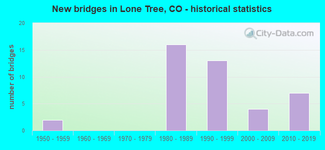
- New bridges - historical statistics
- 21950-1959
- 161980-1989
- 131990-1999
- 42000-2009
- 72010-2019
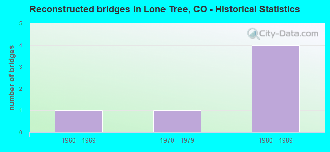
- Reconstructed bridges - Historical Statistics
- 11960-1969
- 11970-1979
- 41980-1989
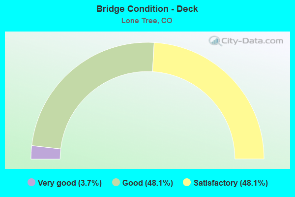
- Bridge Condition - Deck
- 3.7%Very good
- 48.1%Good
- 48.1%Satisfactory
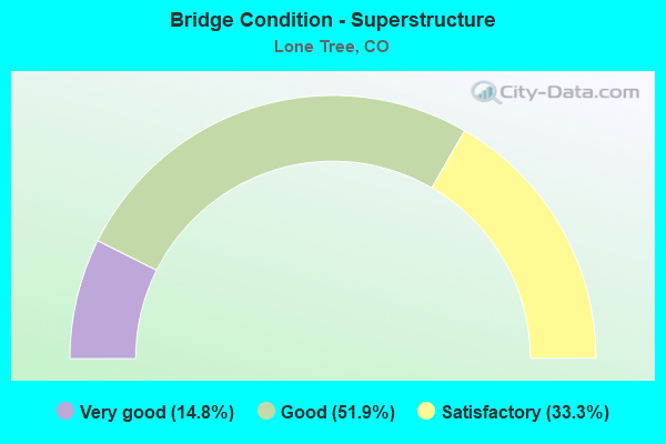
- Bridge Condition - Superstructure
- 14.8%Very good
- 51.9%Good
- 33.3%Satisfactory
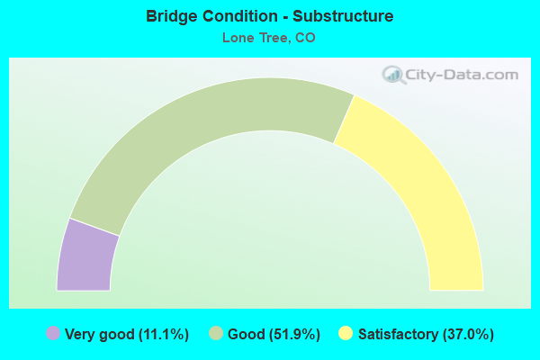
- Bridge Condition - Substructure
- 11.1%Very good
- 51.9%Good
- 37.0%Satisfactory
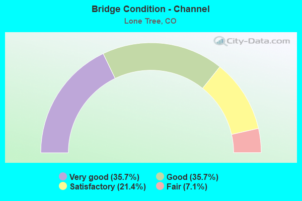
- Bridge Condition - Channel
- 35.7%Very good
- 35.7%Good
- 21.4%Satisfactory
- 7.1%Fair
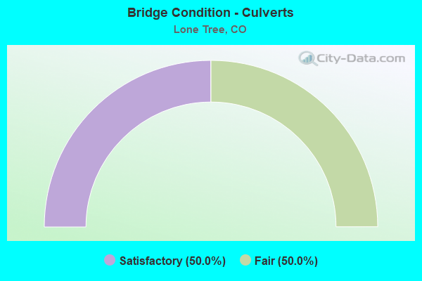
- Bridge Condition - Culverts
- 50.0%Satisfactory
- 50.0%Fair
Find on map >> Show street view
Structure Number: DOU06A-01., Location: AT INT OF LONE TREE PKWY (Lat: 39.546986, Lng: -104.885933), Route carried "on" structure: County highway , Year Built: 1985, Status: Open, Structure Length: 0.65m (2.13ft), Average Daily Traffic: 16,337 (year 2022), Truck Traffic: 4%, Average Future Daily Traffic: 21,891 (year 2042), Design Load: HS 20+Mod, Features Intersected: WILLOW CREEK, Facility Carried by Structure: YOSEMITE STREET
Minimum Vertical Clearance: 30.45m (99.90ft), Kilometerpoint: 0.016, Lanes on structure: 6, Owner: County Highway Agency, Approaching Roadway Width: 20.8m (68.2ft), Skew: 20 degrees, Material/Design: Aluminum, Iron, Design/Construction: Culvert, Number Of Spans In Main Unit: 2, Length of Maximum Span: 2.7m (8.9ft), Curb or Sidewalk Widths: Left: 2.1m (6.9ft), Right: 2.4m (7.9ft), Out-to-Out Width: 41.8m (137.1ft)
Condition: Channel: Satisfactory, Culverts: Satisfactory, Inventory Rating: 92.2 metric tons, Method Used To Determine Inventory Rating: Load Factor (LF), Structural Evaluation: Equal to present minimum criteria, Waterway Adequacy: Equal to present desirable criteria, Approach Roadway Alignment: Equal to present desirable criteria, Designated Inspection Frequency: Every 24 months, Inspection Date: January 2021
Find on map >> Show street view
Structure Number: DOU06B-00.1, Location: .1 MI WEST OF YOSEMITE ST (Lat: 39.554969, Lng: -104.885925), Route carried "on" structure: County highway , Year Built: 1985, Status: Open, Structure Length: 0.76m (2.49ft), Average Daily Traffic: 2,737 (year 2021), Truck Traffic: 4%, Average Future Daily Traffic: 3,667 (year 2041), Design Load: HS 20+Mod, Features Intersected: WILLOW CREEK, Facility Carried by Structure: MAXIMUS DR
Minimum Vertical Clearance: 30.45m (99.90ft), Kilometerpoint: 1.007, Lanes on structure: 2, Owner: County Highway Agency, Approaching Roadway Width: 14.9m (48.9ft), Material/Design: Aluminum, Iron, Design/Construction: Culvert, Number Of Spans In Main Unit: 2, Length of Maximum Span: 3.0m (9.8ft), Curb or Sidewalk Widths: Left: 0.0m, Right: 1.6m (5.2ft), Out-to-Out Width: 53.2m (174.5ft)
Condition: Channel: Satisfactory, Culverts: Fair, Structural Evaluation: Somewhat better than minimum adequacy, Waterway Adequacy: Equal to present desirable criteria, Approach Roadway Alignment: Equal to present desirable criteria, Designated Inspection Frequency: Every 24 months, Inspection Date: January 2021
Find on map >> Show street view
Structure Number: DOU06B-00.2, Location: 0.2 MI NW OF YOSEMITE AVE (Lat: 39.556936, Lng: -104.885011), Route carried "on" structure: County highway , Year Built: 1985, Status: Open, Structure Length: 1.56m (5.12ft), Average Daily Traffic: 7,538 (year 2021), Truck Traffic: 4%, Average Future Daily Traffic: 10,101 (year 2041), Design Load: HS 20+Mod, Features Intersected: WILLOW CREEK, Facility Carried by Structure: PARK MEADOWS DR
Minimum Vertical Clearance: 30.45m (99.90ft), Kilometerpoint: 2.071, Lanes on structure: 4, Owner: County Highway Agency, Approaching Roadway Width: 16.8m (55.1ft), Skew: 30 degrees, Material/Design: Steel, Design/Construction: Culvert, Number Of Spans In Main Unit: 4, Length of Maximum Span: 3.6m (11.8ft), Curb or Sidewalk Widths: Left: 1.7m (5.6ft), Right: 0.0m, Out-to-Out Width: 35.4m (116.1ft)
Condition: Channel: Satisfactory, Culverts: Fair, Structural Evaluation: Somewhat better than minimum adequacy, Waterway Adequacy: Better than present minimum criteria, Approach Roadway Alignment: Equal to present desirable criteria, Designated Inspection Frequency: Every 24 months, Inspection Date: January 2021
Find on map >> Show street view
Structure Number: DOUHESS-2.13, Location: 2.13M E. OF S. HAVANA ST. (Lat: 39.493306, Lng: -104.849511), Route carried "on" structure: County highway , Year Built: 2012, Status: Open, Structure Length: 2.80m (9.19ft), Average Daily Traffic: 9,535 (year 2021), Truck Traffic: 9%, Average Future Daily Traffic: 12,776 (year 2041), Design Load: HS 20, Features Intersected: LIVESTOCK CROSSING, Facility Carried by Structure: HESS ROAD
Minimum Vertical Clearance: 30.45m (99.90ft), Kilometerpoint: 2.562, Lanes on structure: 2, Owner: County Highway Agency, Approaching Roadway Width: 9.1m (29.9ft), Material/Design: Prestressed concrete, Design/Construction: Stringer/Multi-beam, Number Of Spans In Main Unit: 1, Length of Maximum Span: 26.5m (86.9ft), Curb-To-Curb Width: 11.0m (36.1ft), Out-to-Out Width: 11.9m (39.0ft)
Condition: Deck: Good, Superstructure: Good, Substructure: Good, Operating Rating: 73.5 metric tons, Method Used To Determine Operating Rating: Load Factor (LF), Inventory Rating: 47.9 metric tons, Method Used To Determine Inventory Rating: Load Factor (LF), Structural Evaluation: Better than present minimum criteria, Deck Geometry: Meets minimum limits, Approach Roadway Alignment: Equal to present desirable criteria, Designated Inspection Frequency: Every 24 months, Inspection Date: Febuary 2021, Deck Structure Type: Concrete Cast-file-Place, Wearing Surface/Protective System: Wearing Surface: Bituminous, Membrane: Built-up, Deck Protection: Epoxy Coated Reinforcing
Find on map >> Show street view
Structure Number: DOURDG-00.73, Location: 0.73 MI E OF I25 (Lat: 39.522022, Lng: -104.852903), Route carried "on" structure: City street , Year Built: 2010, Status: Open, Structure Length: 4.30m (14.11ft), Average Daily Traffic: 16,913 (year 2022), Truck Traffic: 2%, Average Future Daily Traffic: 22,663 (year 2042), Features Intersected: HAPPY CANYON CREEK, Facility Carried by Structure: EB RIDGEGATE PKWY
Minimum Vertical Clearance: 30.45m (99.90ft), Kilometerpoint: 0.789, Lanes on structure: 3, Owner: City or Municipal Highway Agency, Approaching Roadway Width: 11.9m (39.0ft), Material/Design: Prestressed concrete, Design/Construction: Box Beam or Girders - Single/Spread, Number Of Spans In Main Unit: 1, Length of Maximum Span: 41.1m (134.8ft), Curb or Sidewalk Widths: Left: 0.0m, Right: 1.7m (5.6ft), Curb-To-Curb Width: 10.7m (35.1ft), Out-to-Out Width: 16.0m (52.5ft)
Condition: Deck: Satisfactory, Superstructure: Satisfactory, Substructure: Good, Channel: Good, Operating Rating: 70.2 metric tons, Method Used To Determine Operating Rating: Load and Resistance Factor (LRFR), Inventory Rating: 42.1 metric tons, Method Used To Determine Inventory Rating: Load and Resistance Factor (LRFR), Structural Evaluation: Equal to present minimum criteria, Deck Geometry: High priority of replacement, Waterway Adequacy: Equal to present desirable criteria, Approach Roadway Alignment: Equal to present desirable criteria, Designated Inspection Frequency: Every 24 months, Inspection Date: January 2021, Deck Structure Type: Concrete Cast-file-Place, Wearing Surface/Protective System: Wearing Surface: Bituminous, Deck Protection: Epoxy Coated Reinforcing
Find on map >> Show street view
Structure Number: DOURDG-01.7, Location: 1.7 MI E OF I25 (Lat: 39.520403, Lng: -104.834847), Route carried "on" structure: City street , Year Built: 2010, Status: Open, Structure Length: 6.59m (21.62ft), Average Daily Traffic: 15,986 (year 2022), Truck Traffic: 12%, Average Future Daily Traffic: 21,421 (year 2042), Features Intersected: BADGER GULCH, Facility Carried by Structure: WB RIDGEGATE PKWY
Minimum Vertical Clearance: 30.45m (99.90ft), Kilometerpoint: 2.522, Lanes on structure: 2, Owner: City or Municipal Highway Agency, Approaching Roadway Width: 11.9m (39.0ft), Material/Design: Prestressed concrete continuous, Design/Construction: Box Beam or Girders - Single/Spread, Number Of Spans In Main Unit: 3, Length of Maximum Span: 20.6m (67.6ft), Curb or Sidewalk Widths: Left: 3.0m (9.8ft), Right: 0.0m, Curb-To-Curb Width: 10.5m (34.4ft), Out-to-Out Width: 16.0m (52.5ft)
Condition: Deck: Good, Superstructure: Satisfactory, Substructure: Good, Channel: Good, Operating Rating: 36.3 metric tons, Method Used To Determine Operating Rating: Field evaluation and documented engineering judgment, Inventory Rating: 32.7 metric tons, Method Used To Determine Inventory Rating: Field evaluation and documented engineering judgment, Structural Evaluation: Equal to present minimum criteria, Deck Geometry: Somewhat better than minimum adequacy, Waterway Adequacy: Equal to present desirable criteria, Approach Roadway Alignment: Equal to present desirable criteria, Designated Inspection Frequency: Every 24 months, Inspection Date: January 2021, Deck Structure Type: Concrete Cast-file-Place, Wearing Surface/Protective System: Wearing Surface: Bituminous, Membrane: Built-up, Deck Protection: Epoxy Coated Reinforcing
Find on map >> Show street view
Structure Number: F-17-CR, Location: 3.9 MI SO OF JCT I 470 (Lat: 39.509844, Lng: -104.870936), Route carried "on" structure: Interstate 25A, Year Built: 1999, Status: Open, Structure Length: 2.02m (6.63ft), Average Daily Traffic: 116,000 (year 2020), Truck Traffic: 5%, Average Future Daily Traffic: 165,880 (year 2040), Design Load: HS 20, Features Intersected: HAPPY CANYON CREEK, Facility Carried by Structure: I 25 ML
Minimum Vertical Clearance: 30+ m (98+ ft), Kilometerpoint: 307.367, Lanes on structure: 8, Base Highway Network: Yes, Owner: State Highway Agency, Approaching Roadway Width: 34.1m (111.9ft), Skew: 30 degrees, Material/Design: Prestressed concrete, Design/Construction: Box Beam or Girders - Multiple, Number Of Spans In Main Unit: 1, Length of Maximum Span: 19.6m (64.3ft), Curb-To-Curb Width: 40.8m (133.9ft), Out-to-Out Width: 42.2m (138.5ft)
Condition: Deck: Satisfactory, Superstructure: Good, Substructure: Satisfactory, Channel: Very good, Operating Rating: 59.2 metric tons, Method Used To Determine Operating Rating: Load Factor (LF), Inventory Rating: 33.7 metric tons, Method Used To Determine Inventory Rating: Load Factor (LF), Structural Evaluation: Equal to present minimum criteria, Deck Geometry: Superior to present desirable criteria, Waterway Adequacy: Equal to present desirable criteria, Approach Roadway Alignment: Equal to present desirable criteria, Designated Inspection Frequency: Every 24 months, Inspection Date: August 2021, Deck Structure Type: Concrete Cast-file-Place, Wearing Surface/Protective System: Wearing Surface: Monolithic Concrete, Deck Protection: Epoxy Coated Reinforcing
Find on map >> Show street view
Structure Number: F-17-DK, Location: .85 MI N OF JCT I-25 & (Lat: 39.566106, Lng: -104.871997), Route carried "on" structure: Interstate 25A, Year Built: 1958, Year Reconstructed: 1983, Status: Open, Structure Length: 5.52m (18.11ft), Average Daily Traffic: 171,000 (year 2020), Truck Traffic: 7%, Average Future Daily Traffic: 232,560 (year 2040), Design Load: HS 20+Mod, Features Intersected: COUNTY LINE ROAD, Facility Carried by Structure: I 25 ML
Minimum Vertical Clearance: 30+ m (98+ ft), Kilometerpoint: 313.684, Lanes on structure: 10, Lanes under structure: 7, Base Highway Network: Yes, Owner: State Highway Agency, Approaching Roadway Width: 45.7m (149.9ft), Skew: 30 degrees, Material/Design: Concrete continuous, Design/Construction: Tee Beam, Number Of Spans In Main Unit: 4, Length of Maximum Span: 15.8m (51.8ft), Curb-To-Curb Width: 45.7m (149.9ft), Out-to-Out Width: 47.3m (155.2ft)
Condition: Deck: Satisfactory, Superstructure: Satisfactory, Substructure: Satisfactory, Operating Rating: 24.4 metric tons, Method Used To Determine Operating Rating: Load Factor (LF), Inventory Rating: 14.6 metric tons, Method Used To Determine Inventory Rating: Load Factor (LF), Structural Evaluation: High priority of corrective action, Deck Geometry: Superior to present desirable criteria, Underclear: High priority of corrective action, Approach Roadway Alignment: Equal to present desirable criteria, Length Of Structure Improvement: 5.52m (18.11ft), Designated Inspection Frequency: Every 24 months, Inspection Date: Febuary 2022, Deck Structure Type: Other, Wearing Surface/Protective System: Wearing Surface: Bituminous, Membrane: Preformed Fabric
Find on map >> Show street view
Structure Number: F-17-HL, Location: 4.5 M E OF JCT SH 177 (Lat: 39.558386, Lng: -104.881503), Route carried "on" structure: State highway 470A, Year Built: 1984, Year Reconstructed: 1991, Status: Open, Structure Length: 5.02m (16.47ft), Average Daily Traffic: 47,500 (year 2020), Truck Traffic: 2%, Average Future Daily Traffic: 63,175 (year 2040), Design Load: HS 20+Mod, Features Intersected: YOSEMITE STREET, Facility Carried by Structure: SH 470 ML EBND
Minimum Vertical Clearance: 30+ m (98+ ft), Kilometerpoint: 41.225, Lanes on structure: 3, Lanes under structure: 8, Base Highway Network: Yes, Owner: State Highway Agency, Approaching Roadway Width: 15.2m (49.9ft), Skew: 11 degrees, Material/Design: Prestressed concrete continuous, Design/Construction: Stringer/Multi-beam, Number Of Spans In Main Unit: 2, Length of Maximum Span: 25.9m (85.0ft), Curb-To-Curb Width: 13.6m (44.6ft), Out-to-Out Width: 16.3m (53.5ft)
Condition: Deck: Good, Superstructure: Good, Substructure: Good, Operating Rating: 52.6 metric tons, Method Used To Determine Operating Rating: Load Factor (LF), Inventory Rating: 25.4 metric tons, Method Used To Determine Inventory Rating: Load Factor (LF), Structural Evaluation: Equal to present minimum criteria, Deck Geometry: High priority of corrective action, Underclear: Meets minimum limits, Approach Roadway Alignment: Equal to present desirable criteria, Designated Inspection Frequency: Every 24 months, Inspection Date: December 2021, Deck Structure Type: Concrete Cast-file-Place, Wearing Surface/Protective System: Wearing Surface: Bituminous, Membrane: Preformed Fabric, Deck Protection: Epoxy Coated Reinforcing
Find on map >> Show street view
Structure Number: F-17-HM, Location: .8 MI W OF JCT I 25 (Lat: 39.558581, Lng: -104.881331), Route carried "on" structure: State highway 470A, Year Built: 1984, Year Reconstructed: 1991, Status: Open, Structure Length: 5.01m (16.44ft), Average Daily Traffic: 47,500 (year 2020), Truck Traffic: 2%, Average Future Daily Traffic: 63,175 (year 2040), Design Load: HS 20+Mod, Features Intersected: YOSEMITE STREET, Facility Carried by Structure: SH 470 ML WBND
Minimum Vertical Clearance: 30+ m (98+ ft), Kilometerpoint: 41.220, Lanes on structure: 3, Lanes under structure: 8, Base Highway Network: Yes, Owner: State Highway Agency, Approaching Roadway Width: 23.2m (76.1ft), Skew: 11 degrees, Material/Design: Prestressed concrete continuous, Design/Construction: Stringer/Multi-beam, Number Of Spans In Main Unit: 2, Length of Maximum Span: 25.9m (85.0ft), Curb-To-Curb Width: 18.1m (59.4ft), Out-to-Out Width: 19.1m (62.7ft)
Condition: Deck: Good, Superstructure: Good, Substructure: Good, Operating Rating: 52.6 metric tons, Method Used To Determine Operating Rating: Load Factor (LF), Inventory Rating: 25.4 metric tons, Method Used To Determine Inventory Rating: Load Factor (LF), Structural Evaluation: Equal to present minimum criteria, Deck Geometry: Better than present minimum criteria, Underclear: Equal to present minimum criteria, Approach Roadway Alignment: Equal to present desirable criteria, Designated Inspection Frequency: Every 24 months, Inspection Date: December 2021, Deck Structure Type: Concrete Cast-file-Place, Wearing Surface/Protective System: Wearing Surface: Bituminous, Membrane: Preformed Fabric, Deck Protection: Epoxy Coated Reinforcing
Find on map >> Show street view
Structure Number: F-17-HN, Location: 3.5 M E OF JCT SH 177 (Lat: 39.563972, Lng: -104.897239), Route carried "on" structure: State highway 470A, Year Built: 1984, Status: Open, Structure Length: 4.25m (13.94ft), Average Daily Traffic: 47,500 (year 2020), Truck Traffic: 2%, Average Future Daily Traffic: 63,175 (year 2040), Design Load: HS 20, Features Intersected: ACRES GREEN DRIVE, Facility Carried by Structure: SH 470 ML EBND
Minimum Vertical Clearance: 30+ m (98+ ft), Kilometerpoint: 39.632, Lanes on structure: 3, Lanes under structure: 4, Base Highway Network: Yes, Owner: State Highway Agency, Approaching Roadway Width: 15.2m (49.9ft), Skew: 10 degrees, Material/Design: Prestressed concrete continuous, Design/Construction: Stringer/Multi-beam, Number Of Spans In Main Unit: 2, Length of Maximum Span: 21.5m (70.5ft), Curb-To-Curb Width: 11.8m (38.7ft), Out-to-Out Width: 16.1m (52.8ft)
Condition: Deck: Good, Superstructure: Satisfactory, Substructure: Good, Operating Rating: 56.7 metric tons, Method Used To Determine Operating Rating: Load Factor (LF), Inventory Rating: 34.0 metric tons, Method Used To Determine Inventory Rating: Load Factor (LF), Structural Evaluation: Equal to present minimum criteria, Deck Geometry: High priority of replacement, Underclear: Somewhat better than minimum adequacy, Approach Roadway Alignment: Equal to present desirable criteria, Designated Inspection Frequency: Every 24 months, Inspection Date: December 2021, Deck Structure Type: Concrete Cast-file-Place, Wearing Surface/Protective System: Wearing Surface: Bituminous, Membrane: Preformed Fabric, Deck Protection: Epoxy Coated Reinforcing
Find on map >> Show street view
Structure Number: F-17-HO, Location: 1.3 M W OF JCT I 25 (Lat: 39.564200, Lng: -104.897258), Route carried "on" structure: State highway 470A, Year Built: 1984, Status: Open, Structure Length: 4.25m (13.94ft), Average Daily Traffic: 47,500 (year 2020), Truck Traffic: 2%, Average Future Daily Traffic: 63,175 (year 2040), Design Load: HS 20, Features Intersected: ACRES GREEN DRIVE, Facility Carried by Structure: SH 470 ML WBND
Minimum Vertical Clearance: 30+ m (98+ ft), Kilometerpoint: 39.632, Lanes on structure: 3, Lanes under structure: 4, Base Highway Network: Yes, Owner: State Highway Agency, Approaching Roadway Width: 15.8m (51.8ft), Skew: 10 degrees, Material/Design: Prestressed concrete continuous, Design/Construction: Stringer/Multi-beam, Number Of Spans In Main Unit: 2, Length of Maximum Span: 21.5m (70.5ft), Curb-To-Curb Width: 11.6m (38.1ft), Out-to-Out Width: 16.8m (55.1ft)
Condition: Deck: Good, Superstructure: Good, Substructure: Good, Operating Rating: 56.7 metric tons, Method Used To Determine Operating Rating: Load Factor (LF), Inventory Rating: 34.0 metric tons, Method Used To Determine Inventory Rating: Load Factor (LF), Structural Evaluation: Better than present minimum criteria, Deck Geometry: High priority of replacement, Underclear: Somewhat better than minimum adequacy, Approach Roadway Alignment: Equal to present desirable criteria, Designated Inspection Frequency: Every 24 months, Inspection Date: December 2021, Deck Structure Type: Concrete Cast-file-Place, Wearing Surface/Protective System: Wearing Surface: Bituminous, Membrane: Preformed Fabric, Deck Protection: Epoxy Coated Reinforcing
Find on map >> Show street view
Structure Number: F-17-IC, Location: 1.5 MI W OF JCT I 25 (Lat: 39.563075, Lng: -104.887886), Route carried "on" structure: State highway 470A, Year Built: 1984, Status: Open, Structure Length: 1.49m (4.89ft), Average Daily Traffic: 95,000 (year 2020), Truck Traffic: 2%, Average Future Daily Traffic: 126,350 (year 2040), Design Load: HS 20, Features Intersected: WILLOW CREEK, Facility Carried by Structure: SH 470 ML
Minimum Vertical Clearance: 30+ m (98+ ft), Kilometerpoint: 40.457, Lanes on structure: 6, Base Highway Network: Yes, Owner: State Highway Agency, Approaching Roadway Width: 23.2m (76.1ft), Skew: 14 degrees, Material/Design: Concrete, Design/Construction: Culvert, Number Of Spans In Main Unit: 3, Length of Maximum Span: 4.8m (15.7ft), Out-to-Out Width: 69.6m (228.3ft)
Condition: Channel: Good, Culverts: Satisfactory, Operating Rating: 89.8 metric tons, Method Used To Determine Operating Rating: Field evaluation and documented engineering judgment, Inventory Rating: 89.8 metric tons, Method Used To Determine Inventory Rating: Field evaluation and documented engineering judgment, Structural Evaluation: Equal to present minimum criteria, Waterway Adequacy: Superior to present desirable criteria, Approach Roadway Alignment: Equal to present desirable criteria, Designated Inspection Frequency: Every 24 months, Inspection Date: December 2021
Find on map >> Show street view
Structure Number: F-17-ID, Location: NBND RAMP, N. OF JCT I-25 (Lat: 39.558419, Lng: -104.870200), Route carried "on" structure: Ramp Interstate 25A, Year Built: 1983, Year Reconstructed: 1991, Status: Open, Structure Length: 7.00m (22.97ft), Average Daily Traffic: 85,500 (year 2020), Truck Traffic: 7%, Average Future Daily Traffic: 116,280 (year 2040), Design Load: HS 20, Features Intersected: RAMP TO COUNTY LINE RD R, Facility Carried by Structure: 25NB TO CO LINE RD
Minimum Vertical Clearance: 30+ m (98+ ft), Kilometerpoint: 0.513, Lanes on structure: 4, Lanes under structure: 1, Base Highway Network: Yes, Owner: State Highway Agency, Approaching Roadway Width: 23.2m (76.1ft), Skew: 6 degrees, Material/Design: Prestressed concrete continuous, Design/Construction: Tee Beam, Number Of Spans In Main Unit: 3, Length of Maximum Span: 30.2m (99.1ft), Curb-To-Curb Width: 18.9m (62.0ft), Out-to-Out Width: 20.0m (65.6ft)
Condition: Deck: Satisfactory, Superstructure: Satisfactory, Substructure: Satisfactory, Operating Rating: 57.6 metric tons, Method Used To Determine Operating Rating: Load Factor (LF), Inventory Rating: 34.6 metric tons, Method Used To Determine Inventory Rating: Load Factor (LF), Structural Evaluation: Equal to present minimum criteria, Deck Geometry: Superior to present desirable criteria, Underclear: Better than present minimum criteria, Approach Roadway Alignment: Equal to present desirable criteria, Designated Inspection Frequency: Every 48 months, Inspection Date: July 2019, Deck Structure Type: Concrete Cast-file-Place, Wearing Surface/Protective System: Wearing Surface: Bituminous, Membrane: Preformed Fabric, Deck Protection: Epoxy Coated Reinforcing
Find on map >> Show street view
Structure Number: F-17-IE, Location: SB ONRAMP N.OF C470 (Lat: 39.558639, Lng: -104.871606), Route carried "on" structure: Ramp State highway 470A, Year Built: 1983, Year Reconstructed: 1991, Status: Open, Structure Length: 5.24m (17.19ft), Average Daily Traffic: 47,000 (year 2020), Truck Traffic: 2%, Average Future Daily Traffic: 63,450 (year 2040), Design Load: HS 20+Mod, Features Intersected: RMP TO I25 SBND, RTD, Facility Carried by Structure: I 25SB RMP C470 WB
Minimum Vertical Clearance: 30+ m (98+ ft), Kilometerpoint: 0.008, Lanes on structure: 4, Lanes under structure: 1, Base Highway Network: Yes, Owner: State Highway Agency, Approaching Roadway Width: 20.7m (67.9ft), Skew: 5 degrees, Material/Design: Prestressed concrete continuous, Design/Construction: Stringer/Multi-beam, Number Of Spans In Main Unit: 3, Length of Maximum Span: 19.8m (65.0ft), Curb-To-Curb Width: 20.7m (67.9ft), Out-to-Out Width: 21.8m (71.5ft)
Condition: Deck: Good, Superstructure: Good, Substructure: Satisfactory, Operating Rating: 59.0 metric tons, Method Used To Determine Operating Rating: Load Factor (LF), Inventory Rating: 37.2 metric tons, Method Used To Determine Inventory Rating: Load Factor (LF), Structural Evaluation: Equal to present minimum criteria, Deck Geometry: Superior to present desirable criteria, Underclear: Somewhat better than minimum adequacy, Approach Roadway Alignment: Equal to present desirable criteria, Designated Inspection Frequency: Every 24 months, Inspection Date: August 2021, Deck Structure Type: Concrete Cast-file-Place, Wearing Surface/Protective System: Wearing Surface: Bituminous, Membrane: Built-up, Deck Protection: Epoxy Coated Reinforcing
Find on map >> Show street view
Structure Number: F-17-IQ, Location: TOP FLYOVER, JCT I-25 &am (Lat: 39.554603, Lng: -104.869647), Route carried "on" structure: Ramp State highway 470A, Year Built: 1985, Status: Open, Structure Length: 23.82m (78.15ft), Average Daily Traffic: 47,000 (year 2020), Truck Traffic: 2%, Average Future Daily Traffic: 63,450 (year 2040), Design Load: HS 20+Mod, Features Intersected: I 25, SH 470 ML, RAMPS R, Facility Carried by Structure: I25NB TO C470WB
Minimum Vertical Clearance: 30+ m (98+ ft), Kilometerpoint: 0.292, Lanes on structure: 1, Lanes under structure: 12, Base Highway Network: Yes, Owner: State Highway Agency, Approaching Roadway Width: 8.2m (26.9ft), Skew: 10 degrees, Material/Design: Steel continuous, Design/Construction: Box Beam or Girders - Single/Spread, Number Of Spans In Main Unit: 6, Length of Maximum Span: 47.3m (155.2ft), Curb-To-Curb Width: 8.2m (26.9ft), Out-to-Out Width: 9.3m (30.5ft)
Condition: Deck: Satisfactory, Superstructure: Good, Substructure: Satisfactory, Operating Rating: 57.8 metric tons, Method Used To Determine Operating Rating: Load Factor (LF), Inventory Rating: 32.8 metric tons, Method Used To Determine Inventory Rating: Load Factor (LF), Structural Evaluation: Equal to present minimum criteria, Deck Geometry: Superior to present desirable criteria, Underclear: Equal to present desirable criteria, Approach Roadway Alignment: Equal to present desirable criteria, Designated Inspection Frequency: Every 24 months, Critical Feature Inspection Frequency: Every 24 months, Inspection Date: August 2021, Critical Feature Inspection Date: August 2021, Deck Structure Type: Concrete Cast-file-Place, Wearing Surface/Protective System: Wearing Surface: Bituminous, Membrane: Preformed Fabric, Deck Protection: Epoxy Coated Reinforcing
Find on map >> Show street view
Structure Number: F-17-IT, Location: MID-LEVEL ABOVE JCT I-25 (Lat: 39.554842, Lng: -104.871317), Route carried "on" structure: Ramp Interstate 25A, Year Built: 1985, Status: Open, Structure Length: 19.40m (63.65ft), Average Daily Traffic: 80,000 (year 2020), Truck Traffic: 6%, Average Future Daily Traffic: 110,400 (year 2040), Design Load: HS 20+Mod, Features Intersected: I 25, SH 470 ML R, Facility Carried by Structure: C470 EB TO 25 NB
Minimum Vertical Clearance: 5.56m (18.24ft), Kilometerpoint: 0.229, Lanes on structure: 2, Lanes under structure: 8, Base Highway Network: Yes, Owner: State Highway Agency, Approaching Roadway Width: 11.6m (38.1ft), Skew: 10 degrees, Material/Design: Steel continuous, Design/Construction: Box Beam or Girders - Single/Spread, Number Of Spans In Main Unit: 4, Length of Maximum Span: 56.4m (185.0ft), Curb-To-Curb Width: 11.6m (38.1ft), Out-to-Out Width: 12.6m (41.3ft)
Condition: Deck: Satisfactory, Superstructure: Satisfactory, Substructure: Satisfactory, Operating Rating: 69.9 metric tons, Method Used To Determine Operating Rating: Load Factor (LF), Inventory Rating: 41.7 metric tons, Method Used To Determine Inventory Rating: Load Factor (LF), Structural Evaluation: Equal to present minimum criteria, Deck Geometry: Superior to present desirable criteria, Underclear: Equal to present desirable criteria, Approach Roadway Alignment: Equal to present desirable criteria, Designated Inspection Frequency: Every 24 months, Critical Feature Inspection Frequency: Every 24 months, Inspection Date: August 2021, Critical Feature Inspection Date: August 2021, Deck Structure Type: Concrete Cast-file-Place, Wearing Surface/Protective System: Wearing Surface: Bituminous, Membrane: Preformed Fabric, Deck Protection: Epoxy Coated Reinforcing
Find on map >> Show street view
Structure Number: F-17-J, Location: GREENWOOD VILLAGE (Lat: 39.624164, Lng: -104.962156), Route carried "on" structure: State highway 88A, Year Built: 1959, Year Reconstructed: 1965, Status: Open, Structure Length: 2.28m (7.48ft), Average Daily Traffic: 28,000 (year 2020), Truck Traffic: 4%, Average Future Daily Traffic: 29,960 (year 2040), Design Load: H 20, Features Intersected: LITTLE DRY CREEK, Facility Carried by Structure: SH 88 ML
Minimum Vertical Clearance: 30+ m (98+ ft), Kilometerpoint: 18.334, Lanes on structure: 4, Base Highway Network: Yes, Owner: State Highway Agency, Approaching Roadway Width: 16.2m (53.1ft), Skew: 5 degrees, Material/Design: Concrete, Design/Construction: Culvert, Number Of Spans In Main Unit: 3, Length of Maximum Span: 8.3m (27.2ft), Curb or Sidewalk Widths: Left: 1.6m (5.2ft), Right: 0.0m, Curb-To-Curb Width: 16.2m (53.1ft), Out-to-Out Width: 20.1m (65.9ft)
Condition: Channel: Fair, Culverts: Fair, Operating Rating: 36.3 metric tons, Method Used To Determine Operating Rating: Field evaluation and documented engineering judgment, Inventory Rating: 32.7 metric tons, Method Used To Determine Inventory Rating: Field evaluation and documented engineering judgment, Structural Evaluation: Somewhat better than minimum adequacy, Deck Geometry: Meets minimum limits, Waterway Adequacy: Equal to present desirable criteria, Approach Roadway Alignment: Equal to present desirable criteria, Designated Inspection Frequency: Every 24 months, Inspection Date: June 2020
Find on map >> Show street view
Structure Number: F-17-JM, Location: 1.3 MI S OF C-470 (Lat: 39.536106, Lng: -104.869069), Route carried "on" structure: City street , Year Built: 1990, Status: Open, Structure Length: 8.62m (28.28ft), Average Daily Traffic: 65,017 (year 2021), Truck Traffic: 8%, Average Future Daily Traffic: 87,123 (year 2041), Design Load: HS 20+Mod, Features Intersected: I 25 ML, Facility Carried by Structure: LINCOLN AVE
Minimum Vertical Clearance: 5.72m (18.77ft), Kilometerpoint: 2.978, Lanes on structure: 7, Lanes under structure: 10, Owner: State Highway Agency, Approaching Roadway Width: 29.0m (95.1ft), Material/Design: Steel continuous, Design/Construction: Box Beam or Girders - Single/Spread, Number Of Spans In Main Unit: 2, Length of Maximum Span: 44.7m (146.7ft), Curb or Sidewalk Widths: Left: 2.4m (7.9ft), Right: 1.5m (4.9ft), Curb-To-Curb Width: 28.7m (94.2ft), Out-to-Out Width: 34.1m (111.9ft)
Condition: Deck: Good, Superstructure: Satisfactory, Substructure: Good, Operating Rating: 69.0 metric tons, Method Used To Determine Operating Rating: Load Factor (LF), Inventory Rating: 39.0 metric tons, Method Used To Determine Inventory Rating: Load Factor (LF), Structural Evaluation: Equal to present minimum criteria, Deck Geometry: Somewhat better than minimum adequacy, Underclear: Better than present minimum criteria, Approach Roadway Alignment: Equal to present desirable criteria, Designated Inspection Frequency: Every 24 months, Inspection Date: September 2021, Deck Structure Type: Concrete Cast-file-Place, Wearing Surface/Protective System: Wearing Surface: Bituminous, Membrane: Preformed Fabric, Deck Protection: Epoxy Coated Reinforcing
Find on map >> Show street view
Structure Number: F-17-JU, Location: JCT I 25 AND SH 470 (Lat: 39.555078, Lng: -104.870442), Route carried "on" structure: Interstate 25A, Year Built: 1990, Status: Open, Structure Length: 4.88m (16.01ft), Average Daily Traffic: 80,000 (year 2020), Truck Traffic: 6%, Average Future Daily Traffic: 110,400 (year 2040), Design Load: HS 20+Mod, Features Intersected: SH 470 ML, RAMPS, Facility Carried by Structure: I 25 ML SBND
Minimum Vertical Clearance: 5.54m (18.18ft), Kilometerpoint: 312.453, Lanes on structure: 4, Lanes under structure: 4, Base Highway Network: Yes, Owner: State Highway Agency, Approaching Roadway Width: 23.5m (77.1ft), Skew: 11 degrees, Material/Design: Prestressed concrete continuous, Design/Construction: Stringer/Multi-beam, Number Of Spans In Main Unit: 2, Length of Maximum Span: 23.0m (75.5ft), Curb-To-Curb Width: 20.6m (67.6ft), Out-to-Out Width: 21.5m (70.5ft)
Condition: Deck: Satisfactory, Superstructure: Good, Substructure: Satisfactory, Operating Rating: 64.4 metric tons, Method Used To Determine Operating Rating: Load Factor (LF), Inventory Rating: 38.1 metric tons, Method Used To Determine Inventory Rating: Load Factor (LF), Structural Evaluation: Equal to present minimum criteria, Deck Geometry: Equal to present minimum criteria, Underclear: Better than present minimum criteria, Approach Roadway Alignment: Equal to present desirable criteria, Designated Inspection Frequency: Every 24 months, Inspection Date: August 2021, Deck Structure Type: Concrete Cast-file-Place, Wearing Surface/Protective System: Wearing Surface: Bituminous, Membrane: Preformed Fabric, Deck Protection: Epoxy Coated Reinforcing
Find on map >> Show street view
Structure Number: F-17-JV, Location: JCT I 25 AND SH 470 (Lat: 39.555064, Lng: -104.870147), Route carried "on" structure: Interstate 25A, Year Built: 1990, Status: Open, Structure Length: 4.88m (16.01ft), Average Daily Traffic: 80,000 (year 2020), Truck Traffic: 6%, Average Future Daily Traffic: 110,400 (year 2040), Design Load: HS 20+Mod, Features Intersected: SH 470 ML, RAMPS, Facility Carried by Structure: I25 ML NBND
Minimum Vertical Clearance: 5.84m (19.16ft), Kilometerpoint: 312.448, Lanes on structure: 4, Lanes under structure: 4, Base Highway Network: Yes, Owner: State Highway Agency, Approaching Roadway Width: 16.5m (54.1ft), Skew: 11 degrees, Material/Design: Prestressed concrete continuous, Design/Construction: Stringer/Multi-beam, Number Of Spans In Main Unit: 2, Length of Maximum Span: 23.3m (76.4ft), Curb-To-Curb Width: 20.7m (67.9ft), Out-to-Out Width: 23.5m (77.1ft)
Condition: Deck: Satisfactory, Superstructure: Good, Substructure: Satisfactory, Operating Rating: 64.4 metric tons, Method Used To Determine Operating Rating: Load Factor (LF), Inventory Rating: 38.1 metric tons, Method Used To Determine Inventory Rating: Load Factor (LF), Structural Evaluation: Equal to present minimum criteria, Deck Geometry: Equal to present minimum criteria, Underclear: High priority of corrective action, Approach Roadway Alignment: Equal to present desirable criteria, Designated Inspection Frequency: Every 24 months, Inspection Date: August 2021, Deck Structure Type: Concrete Cast-file-Place, Wearing Surface/Protective System: Wearing Surface: Bituminous, Membrane: Preformed Fabric, Deck Protection: Epoxy Coated Reinforcing
Find on map >> Show street view
Structure Number: F-17-JW, Location: MID-LEVEL ABOVE JCT I-25 (Lat: 39.554567, Lng: -104.870864), Route carried "on" structure: Ramp Interstate 25A, Year Built: 1991, Status: Open, Structure Length: 19.45m (63.81ft), Average Daily Traffic: 80,000 (year 2020), Truck Traffic: 6%, Average Future Daily Traffic: 110,400 (year 2040), Design Load: HS 20+Mod, Features Intersected: I 25, SH 470 ML R, Facility Carried by Structure: E470WB TO 25SB
Minimum Vertical Clearance: 5.46m (17.91ft), Kilometerpoint: 0.277, Lanes on structure: 1, Lanes under structure: 8, Base Highway Network: Yes, Owner: State Highway Agency, Approaching Roadway Width: 8.2m (26.9ft), Material/Design: Steel continuous, Design/Construction: Box Beam or Girders - Single/Spread, Number Of Spans In Main Unit: 5, Length of Maximum Span: 45.0m (147.6ft), Curb-To-Curb Width: 8.2m (26.9ft), Out-to-Out Width: 9.3m (30.5ft)
Condition: Deck: Satisfactory, Superstructure: Good, Substructure: Satisfactory, Operating Rating: 69.9 metric tons, Method Used To Determine Operating Rating: Load Factor (LF), Inventory Rating: 41.7 metric tons, Method Used To Determine Inventory Rating: Load Factor (LF), Structural Evaluation: Equal to present minimum criteria, Deck Geometry: Superior to present desirable criteria, Underclear: Equal to present minimum criteria, Approach Roadway Alignment: Equal to present desirable criteria, Designated Inspection Frequency: Every 24 months, Critical Feature Inspection Frequency: Every 24 months, Inspection Date: August 2021, Critical Feature Inspection Date: August 2021, Deck Structure Type: Concrete Cast-file-Place, Wearing Surface/Protective System: Wearing Surface: Bituminous, Membrane: Preformed Fabric, Deck Protection: Epoxy Coated Reinforcing
Find on map >> Show street view
Structure Number: F-17-JX, Location: TOP FLYOVER, JCT I-25 & 4 (Lat: 39.556664, Lng: -104.871439), Route carried "on" structure: Ramp State highway 470A, Year Built: 1991, Status: Open, Structure Length: 36.45m (119.59ft), Average Daily Traffic: 47,000 (year 2020), Truck Traffic: 2%, Average Future Daily Traffic: 63,450 (year 2040), Design Load: HS 20+Mod, Features Intersected: I 25, SH 470 ML, RAMPS R, Facility Carried by Structure: 25 SB TO E470 EB
Minimum Vertical Clearance: 30+ m (98+ ft), Kilometerpoint: 0.232, Lanes on structure: 2, Lanes under structure: 14, Base Highway Network: Yes, Owner: State Highway Agency, Approaching Roadway Width: 11.6m (38.1ft), Material/Design: Steel continuous, Design/Construction: Box Beam or Girders - Single/Spread, Number Of Spans In Main Unit: 7, Length of Maximum Span: 59.0m (193.6ft), Curb-To-Curb Width: 11.6m (38.1ft), Out-to-Out Width: 12.6m (41.3ft)
Condition: Deck: Satisfactory, Superstructure: Good, Substructure: Good, Operating Rating: 79.8 metric tons, Method Used To Determine Operating Rating: Load Factor (LF), Inventory Rating: 34.5 metric tons, Method Used To Determine Inventory Rating: Load Factor (LF), Structural Evaluation: Better than present minimum criteria, Deck Geometry: Superior to present desirable criteria, Underclear: Superior to present desirable criteria, Approach Roadway Alignment: Equal to present desirable criteria, Designated Inspection Frequency: Every 24 months, Critical Feature Inspection Frequency: Every 24 months, Inspection Date: August 2021, Critical Feature Inspection Date: August 2021, Deck Structure Type: Concrete Cast-file-Place, Wearing Surface/Protective System: Wearing Surface: Bituminous, Membrane: Preformed Fabric, Deck Protection: Epoxy Coated Reinforcing
Find on map >> Show street view
Structure Number: F-17-JY, Location: .85 MI N OF JCT I-25/470 (Lat: 39.566114, Lng: -104.871833), Route carried "on" structure: Ramp Interstate 25A, Year Built: 1991, Status: Open, Structure Length: 5.52m (18.11ft), Average Daily Traffic: 85,500 (year 2020), Truck Traffic: 7%, Average Future Daily Traffic: 116,280 (year 2040), Design Load: HS 20, Features Intersected: COUNTY LINE ROAD R, Facility Carried by Structure: RAMP TO I 25 NBND
Minimum Vertical Clearance: 30+ m (98+ ft), Kilometerpoint: 0.311, Lanes on structure: 1, Lanes under structure: 7, Base Highway Network: Yes, Owner: State Highway Agency, Approaching Roadway Width: 8.2m (26.9ft), Material/Design: Prestressed concrete continuous, Design/Construction: Stringer/Multi-beam, Number Of Spans In Main Unit: 2, Length of Maximum Span: 28.1m (92.2ft), Curb-To-Curb Width: 8.2m (26.9ft), Out-to-Out Width: 9.1m (29.9ft)
Condition: Deck: Good, Superstructure: Good, Substructure: Good, Operating Rating: 87.4 metric tons, Method Used To Determine Operating Rating: Load Factor (LF), Inventory Rating: 52.3 metric tons, Method Used To Determine Inventory Rating: Load Factor (LF), Structural Evaluation: Better than present minimum criteria, Deck Geometry: Superior to present desirable criteria, Underclear: High priority of corrective action, Approach Roadway Alignment: Equal to present desirable criteria, Designated Inspection Frequency: Every 24 months, Inspection Date: December 2021, Deck Structure Type: Concrete Cast-file-Place, Wearing Surface/Protective System: Wearing Surface: Bituminous, Membrane: Preformed Fabric, Deck Protection: Epoxy Coated Reinforcing
Find on map >> Show street view
Structure Number: F-17-OY, Location: EB470/SB25 Ramp (Lat: 39.552803, Lng: -104.870944), Route carried "on" structure: Ramp Interstate 25A, Year Built: 2005, Status: Open, Structure Length: 1.14m (3.74ft), Average Daily Traffic: 85,500 (year 2020), Truck Traffic: 7%, Average Future Daily Traffic: 116,280 (year 2040), Design Load: HS 25 or greater, Features Intersected: LRT, Facility Carried by Structure: C470 EB TO I25 SB
Minimum Vertical Clearance: 30+ m (98+ ft), Kilometerpoint: 0.349, Lanes on structure: 1, Base Highway Network: Yes, Owner: State Highway Agency, Approaching Roadway Width: 7.6m (24.9ft), Skew: 9 degrees, Material/Design: Prestressed concrete, Design/Construction: Box Beam or Girders - Single/Spread, Number Of Spans In Main Unit: 1, Length of Maximum Span: 10.2m (33.5ft), Curb-To-Curb Width: 7.6m (24.9ft), Out-to-Out Width: 25.7m (84.3ft)
Condition: Deck: Satisfactory, Superstructure: Very good, Substructure: Good, Operating Rating: 68.3 metric tons, Method Used To Determine Operating Rating: Load Factor (LF), Inventory Rating: 40.9 metric tons, Method Used To Determine Inventory Rating: Load Factor (LF), Structural Evaluation: Better than present minimum criteria, Deck Geometry: Better than present minimum criteria, Underclear: High priority of corrective action, Approach Roadway Alignment: Equal to present desirable criteria, Designated Inspection Frequency: Every 24 months, Inspection Date: August 2021, Deck Structure Type: Concrete Precast Panels, Wearing Surface/Protective System: Wearing Surface: Monolithic Concrete, Deck Protection: Epoxy Coated Reinforcing
Find on map >> Show street view
Structure Number: F-17-PR, Location: I-25 at I-225 (Lat: 39.633647, Lng: -104.906347), Route carried "on" structure: Interstate 25A, Year Built: 2004, Status: Open, Structure Length: 1.73m (5.68ft), Average Daily Traffic: 223,000 (year 2020), Truck Traffic: 5%, Average Future Daily Traffic: 276,520 (year 2040), Design Load: HS 25 or greater, Features Intersected: I 225 LRT, Facility Carried by Structure: I 25 ML
Minimum Vertical Clearance: 30+ m (98+ ft), Kilometerpoint: 1.191, Lanes on structure: 9, Base Highway Network: Yes, Owner: State Highway Agency, Approaching Roadway Width: 41.5m (136.2ft), Skew: 4 degrees, Material/Design: Prestressed concrete, Design/Construction: Stringer/Multi-beam, Number Of Spans In Main Unit: 1, Length of Maximum Span: 16.4m (53.8ft), Curb-To-Curb Width: 44.2m (145.0ft), Out-to-Out Width: 49.2m (161.4ft)
Condition: Deck: Good, Superstructure: Good, Substructure: Good, Operating Rating: 71.6 metric tons, Method Used To Determine Operating Rating: Load Factor (LF), Inventory Rating: 42.5 metric tons, Method Used To Determine Inventory Rating: Load Factor (LF), Structural Evaluation: Better than present minimum criteria, Deck Geometry: Superior to present desirable criteria, Underclear: High priority of corrective action, Approach Roadway Alignment: Equal to present desirable criteria, Designated Inspection Frequency: Every 24 months, Inspection Date: March 2020, Deck Structure Type: Concrete Precast Panels, Wearing Surface/Protective System: Wearing Surface: Monolithic Concrete, Deck Protection: Epoxy Coated Reinforcing
Find on map >> Show street view
Structure Number: F-17-PT, Location: I25 AT RIDGEGATE PKWY (Lat: 39.522897, Lng: -104.867094), Route carried "on" structure: Interstate 25A, Year Built: 2008, Status: Open, Structure Length: 4.21m (13.81ft), Average Daily Traffic: 116,000 (year 2020), Truck Traffic: 5%, Average Future Daily Traffic: 165,880 (year 2040), Design Load: HL 93, Features Intersected: RIDGEGATE PKWY, Facility Carried by Structure: I 25 ML
Minimum Vertical Clearance: 30+ m (98+ ft), Kilometerpoint: 308.872, Lanes on structure: 9, Lanes under structure: 7, Base Highway Network: Yes, Owner: State Highway Agency, Approaching Roadway Width: 46.6m (152.9ft), Skew: 30 degrees, Material/Design: Prestressed concrete, Design/Construction: Box Beam or Girders - Single/Spread, Number Of Spans In Main Unit: 1, Length of Maximum Span: 40.9m (134.2ft), Curb-To-Curb Width: 46.6m (152.9ft), Out-to-Out Width: 48.2m (158.1ft)
Condition: Deck: Satisfactory, Superstructure: Satisfactory, Substructure: Satisfactory, Inventory Rating: 71.8 metric tons, Method Used To Determine Inventory Rating: Load Factor (LF), Structural Evaluation: Equal to present minimum criteria, Deck Geometry: Superior to present desirable criteria, Approach Roadway Alignment: Equal to present desirable criteria, Designated Inspection Frequency: Every 24 months, Inspection Date: August 2021, Deck Structure Type: Concrete Precast Panels, Wearing Surface/Protective System: Wearing Surface: Latex Concrete, Deck Protection: Epoxy Coated Reinforcing
Find on map >> Show street view
Structure Number: LONE TREE-1, Location: JUST W OF WILLOW STREET (Lat: 39.564111, Lng: -104.888169), Route carried "on" structure: City street , Year Built: 1985, Status: Open, Structure Length: 1.17m (3.84ft), Average Daily Traffic: 2,454 (year 2021), Truck Traffic: 4%, Average Future Daily Traffic: 3,289 (year 2041), Design Load: HS 20, Features Intersected: WILLOW CREEK, Facility Carried by Structure: PARKWAY DRIVE
Minimum Vertical Clearance: 30.45m (99.90ft), Kilometerpoint: 1.315, Lanes on structure: 4, Owner: City or Municipal Highway Agency, Approaching Roadway Width: 19.5m (64.0ft), Skew: 1 degrees, Material/Design: Concrete, Design/Construction: Culvert, Number Of Spans In Main Unit: 3, Length of Maximum Span: 3.7m (12.1ft), Curb or Sidewalk Widths: Left: 1.7m (5.6ft), Right: 0.0m, Out-to-Out Width: 46.5m (152.6ft)
Condition: Channel: Good, Culverts: Satisfactory, Operating Rating: 36.3 metric tons, Method Used To Determine Operating Rating: Field evaluation and documented engineering judgment, Inventory Rating: 32.7 metric tons, Method Used To Determine Inventory Rating: Field evaluation and documented engineering judgment, Structural Evaluation: Equal to present minimum criteria, Waterway Adequacy: Equal to present desirable criteria, Approach Roadway Alignment: Equal to present desirable criteria, Designated Inspection Frequency: Every 48 months, Inspection Date: January 2019
Find on map >> Show street view
Structure Number: LONE TREE-2, Location: .1 MI S OF LINCOLN AVE (Lat: 39.534328, Lng: -104.830094), Route carried "on" structure: City street , Year Built: 1990, Status: Open, Structure Length: 3.66m (12.01ft), Average Daily Traffic: 64 (year 2021), Truck Traffic: 4%, Average Future Daily Traffic: 86 (year 2041), Design Load: HS 20, Features Intersected: HAPPY CANYON CREEK, Facility Carried by Structure: WEST PARKER ROAD
Minimum Vertical Clearance: 30.45m (99.90ft), Kilometerpoint: 0.229, Lanes on structure: 2, Owner: City or Municipal Highway Agency, Approaching Roadway Width: 7.9m (25.9ft), Skew: 2 degrees, Material/Design: Prestressed concrete, Design/Construction: Tee Beam, Number Of Spans In Main Unit: 2, Length of Maximum Span: 17.1m (56.1ft), Curb-To-Curb Width: 11.0m (36.1ft), Out-to-Out Width: 11.7m (38.4ft)
Condition: Deck: Satisfactory, Superstructure: Satisfactory, Substructure: Good, Channel: Very good, Operating Rating: 62.2 metric tons, Method Used To Determine Operating Rating: Load Factor (LF), Inventory Rating: 34.9 metric tons, Method Used To Determine Inventory Rating: Load Factor (LF), Structural Evaluation: Equal to present minimum criteria, Deck Geometry: Superior to present desirable criteria, Waterway Adequacy: Equal to present desirable criteria, Approach Roadway Alignment: Equal to present desirable criteria, Designated Inspection Frequency: Every 24 months, Inspection Date: January 2021, Deck Structure Type: Concrete Cast-file-Place, Wearing Surface/Protective System: Wearing Surface: Bituminous, Membrane: Built-up, Deck Protection: Epoxy Coated Reinforcing
Find on map >> Show street view
Structure Number: LONE TREE-3, Location: 1.3 MI S OF RIDGEGATE (Lat: 39.509853, Lng: -104.870511), Route carried "on" structure: City street , Year Built: 2009, Status: Open, Structure Length: 3.66m (12.01ft), Average Daily Traffic: 1,145 (year 2021), Truck Traffic: 4%, Average Future Daily Traffic: 1,534 (year 2041), Features Intersected: HAPPY CANYON CREEK, Facility Carried by Structure: HAVANA STREET
Minimum Vertical Clearance: 30+ m (98+ ft), Kilometerpoint: 1.765, Lanes on structure: 2, Owner: City or Municipal Highway Agency, Approaching Roadway Width: 12.2m (40.0ft), Skew: 3 degrees, Material/Design: Prestressed concrete, Design/Construction: Box Beam or Girders - Multiple, Number Of Spans In Main Unit: 1, Length of Maximum Span: 35.1m (115.2ft), Curb-To-Curb Width: 12.2m (40.0ft), Out-to-Out Width: 13.1m (43.0ft)
Condition: Deck: Good, Superstructure: Very good, Substructure: Very good, Channel: Very good, Inventory Rating: 76.7 metric tons, Method Used To Determine Inventory Rating: Load and Resistance Factor (LRFR), Structural Evaluation: Equal to present desirable criteria, Deck Geometry: Better than present minimum criteria, Waterway Adequacy: Equal to present desirable criteria, Approach Roadway Alignment: Equal to present desirable criteria, Designated Inspection Frequency: Every 24 months, Inspection Date: January 2021, Deck Structure Type: Concrete Cast-file-Place, Wearing Surface/Protective System: Wearing Surface: Monolithic Concrete, Deck Protection: Epoxy Coated Reinforcing
Find on map >> Show street view
Structure Number: LONE TREE-4, Location: 0.4 MI S OF LINCOLN AVE (Lat: 39.530697, Lng: -104.867989), Route carried "on" structure: City street , Year Built: 2018, Status: Open, Structure Length: 15.24m (50.00ft), Average Daily Traffic: 4 (year 2021), Truck Traffic: 1%, Average Future Daily Traffic: 5 (year 2041), Design Load: HL 93, Features Intersected: I25 ML, Facility Carried by Structure: SKY RIDGE AVE.
Minimum Vertical Clearance: 30+ m (98+ ft), Kilometerpoint: 309.758, Lanes on structure: 4, Lanes under structure: 10, Owner: City or Municipal Highway Agency, Approaching Roadway Width: 16.5m (54.1ft), Material/Design: Prestressed concrete continuous, Design/Construction: Stringer/Multi-beam, Number Of Spans In Main Unit: 4, Length of Maximum Span: 37.6m (123.4ft), Curb or Sidewalk Widths: Left: 0.0m, Right: 3.0m (9.8ft), Curb-To-Curb Width: 16.5m (54.1ft), Out-to-Out Width: 20.4m (66.9ft)
Condition: Deck: Good, Superstructure: Good, Substructure: Good, Channel: Very good, Operating Rating: 53.8 metric tons, Method Used To Determine Operating Rating: Load and Resistance Factor Rating (LRFR) rating reported by rating factor(RF) method using HL-93 loadings, Inventory Rating: 41.5 metric tons, Method Used To Determine Inventory Rating: Load and Resistance Factor Rating (LRFR) rating reported by rating factor(RF) method using HL-93 loadings, Structural Evaluation: Better than present minimum criteria, Deck Geometry: Meets minimum limits, Underclear: Better than present minimum criteria, Waterway Adequacy: Superior to present desirable criteria, Approach Roadway Alignment: Equal to present minimum criteria, Designated Inspection Frequency: Every 24 months, Inspection Date: January 2021, Deck Structure Type: Concrete Cast-file-Place, Wearing Surface/Protective System: Wearing Surface: Bituminous, Membrane: Other, Deck Protection: Epoxy Coated Reinforcing
Find on map >> Show street view
Structure Number: LONE TREE-5, Location: 0.73 MI E OF I25 (Lat: 39.522169, Lng: -104.852744), Route carried "on" structure: City street , Year Built: 2019, Status: Open, Structure Length: 4.30m (14.11ft), Average Daily Traffic: 17,120 (year 2022), Truck Traffic: 2%, Average Future Daily Traffic: 22,941 (year 2042), Features Intersected: HAPPY CANYON CREEK, Facility Carried by Structure: WB RIDGEGATE PKWY
Minimum Vertical Clearance: 30+ m (98+ ft), Kilometerpoint: 0.814, Lanes on structure: 3, Owner: City or Municipal Highway Agency, Approaching Roadway Width: 11.0m (36.1ft), Material/Design: Prestressed concrete, Design/Construction: Box Beam or Girders - Single/Spread, Number Of Spans In Main Unit: 1, Length of Maximum Span: 41.1m (134.8ft), Curb or Sidewalk Widths: Left: 2.6m (8.5ft), Right: 0.0m, Curb-To-Curb Width: 11.0m (36.1ft), Out-to-Out Width: 14.6m (47.9ft)
Condition: Deck: Very good, Superstructure: Very good, Substructure: Very good, Channel: Good, Operating Rating: 67.7 metric tons, Method Used To Determine Operating Rating: Load and Resistance Factor Rating (LRFR) rating reported by rating factor(RF) method using HL-93 loadings, Inventory Rating: 38.2 metric tons, Method Used To Determine Inventory Rating: Load and Resistance Factor Rating (LRFR) rating reported by rating factor(RF) method using HL-93 loadings, Structural Evaluation: Equal to present desirable criteria, Deck Geometry: High priority of replacement, Waterway Adequacy: Equal to present desirable criteria, Approach Roadway Alignment: Equal to present desirable criteria, Designated Inspection Frequency: Every 24 months, Inspection Date: January 2021, Deck Structure Type: Concrete Cast-file-Place, Wearing Surface/Protective System: Wearing Surface: Bituminous, Membrane: Built-up, Deck Protection: Epoxy Coated Reinforcing
Find on map >> Show street view
Structure Number: LONE TREE-6, Location: 1.7 MI E OF I25 (Lat: 39.519592, Lng: -104.835708), Route carried "on" structure: City street , Year Built: 2019, Status: Open, Structure Length: 7.22m (23.69ft), Average Daily Traffic: 16,730 (year 2022), Truck Traffic: 12%, Average Future Daily Traffic: 22,418 (year 2042), Features Intersected: BADGER GULCH, Facility Carried by Structure: EB RIDGEGATE PKWY
Minimum Vertical Clearance: 30.45m (99.90ft), Kilometerpoint: 2.457, Lanes on structure: 2, Owner: City or Municipal Highway Agency, Approaching Roadway Width: 11.9m (39.0ft), Material/Design: Prestressed concrete continuous, Design/Construction: Box Beam or Girders - Single/Spread, Number Of Spans In Main Unit: 3, Length of Maximum Span: 27.4m (89.9ft), Curb or Sidewalk Widths: Left: 0.0m, Right: 5.6m (18.4ft), Curb-To-Curb Width: 11.0m (36.1ft), Out-to-Out Width: 17.7m (58.1ft)
Condition: Deck: Good, Superstructure: Very good, Substructure: Very good, Channel: Very good, Operating Rating: 60.3 metric tons, Method Used To Determine Operating Rating: Load and Resistance Factor Rating (LRFR) rating reported by rating factor(RF) method using HL-93 loadings, Inventory Rating: 33.7 metric tons, Method Used To Determine Inventory Rating: Load and Resistance Factor Rating (LRFR) rating reported by rating factor(RF) method using HL-93 loadings, Structural Evaluation: Equal to present desirable criteria, Deck Geometry: Equal to present minimum criteria, Waterway Adequacy: Equal to present desirable criteria, Approach Roadway Alignment: Equal to present minimum criteria, Designated Inspection Frequency: Every 24 months, Inspection Date: January 2021, Deck Structure Type: Concrete Cast-file-Place, Wearing Surface/Protective System: Wearing Surface: Bituminous, Membrane: Built-up, Deck Protection: Epoxy Coated Reinforcing
Find on map >> Show street view
Structure Number: F-17-IE, Location: SB ONRAMP N.OF C470 (Lat: 39.558639, Lng: -104.871606), Route carried "under" structure: Ramp Interstate 25A, Year Built: 1983, Structure Length: 0. m, Average Daily Traffic: 3,200 (year 2005), Truck Traffic: 8%, Features Intersected: RMP TO I25 SBND, RTD, Facility Carried by Structure: I 25SB RMP C470 WB
Minimum Vertical Clearance: 5.16m (16.93ft), Kilometerpoint: 313.000, Lanes on structure: 4, Lanes under structure: 1, Material/Design: Prestressed concrete continuous, Design/Construction: Stringer/Multi-beam, Length of Maximum Span: 19.8m (65.0ft)
Find on map >> Show street view
Structure Number: F-17-IQ, Location: TOP FLYOVER, JCT I-25 &am (Lat: 39.554603, Lng: -104.869647), Route carried "under" structure: Ramp Interstate 25A, Year Built: 1985, Structure Length: 0. m, Average Daily Traffic: 105,500 (year 2005), Truck Traffic: 9%, Features Intersected: I 25, SH 470 ML, RAMPS R, Facility Carried by Structure: I25NB TO C470WB
Minimum Vertical Clearance: 8.00m (26.25ft), Kilometerpoint: 313.000, Lanes on structure: 1, Lanes under structure: 8, Material/Design: Steel continuous, Design/Construction: Box Beam or Girders - Single/Spread, Length of Maximum Span: 47.3m (155.2ft)
Find on map >> Show street view
Structure Number: F-17-IT, Location: MID-LEVEL ABOVE JCT I-25 (Lat: 39.554842, Lng: -104.871317), Route carried "under" structure: Ramp Interstate 25A, Year Built: 1985, Structure Length: 0. m, Average Daily Traffic: 104,000 (year 2005), Truck Traffic: 21%, Features Intersected: I 25, SH 470 ML R, Facility Carried by Structure: C470 EB TO 25 NB
Minimum Vertical Clearance: 18.25m (59.88ft), Kilometerpoint: 312.760, Lanes on structure: 2, Lanes under structure: 8, Material/Design: Steel continuous, Design/Construction: Box Beam or Girders - Single/Spread, Length of Maximum Span: 56.4m (185.0ft)
Find on map >> Show street view
Structure Number: F-17-JM, Location: 1.3 MI S OF C-470 (Lat: 39.536106, Lng: -104.869069), Route carried "under" structure: Interstate 25A, Year Built: 1990, Structure Length: 0. m, Average Daily Traffic: 59,304 (year 2016), Truck Traffic: 6%, Features Intersected: I 25 ML, Facility Carried by Structure: LINCOLN AVE
Minimum Vertical Clearance: 5.79m (19.00ft), Kilometerpoint: 2.978, Lanes on structure: 7, Lanes under structure: 10, Material/Design: Steel continuous, Design/Construction: Box Beam or Girders - Single/Spread, Length of Maximum Span: 44.7m (146.7ft)
Find on map >> Show street view
Structure Number: F-17-JU, Location: JCT I 25 AND SH 470 (Lat: 39.555078, Lng: -104.870442), Route carried "under" structure: Ramp State highway 470A, Year Built: 1990, Structure Length: 0. m, Average Daily Traffic: 90,200 (year 2005), Truck Traffic: 5%, Features Intersected: SH 470 ML, RAMPS, Facility Carried by Structure: I 25 ML SBND
Minimum Vertical Clearance: 5.89m (19.32ft), Kilometerpoint: 41.754, Lanes on structure: 4, Lanes under structure: 4, Material/Design: Prestressed concrete continuous, Design/Construction: Stringer/Multi-beam, Length of Maximum Span: 23.0m (75.5ft)
Find on map >> Show street view
Structure Number: F-17-JV, Location: JCT I 25 AND SH 470 (Lat: 39.555064, Lng: -104.870147), Route carried "under" structure: State highway 470A, Year Built: 1990, Structure Length: 0. m, Average Daily Traffic: 96,000 (year 2011), Truck Traffic: 5%, Features Intersected: SH 470 ML, RAMPS, Facility Carried by Structure: I25 ML NBND
Minimum Vertical Clearance: 5.38m (17.65ft), Kilometerpoint: 41.770, Lanes on structure: 4, Lanes under structure: 4, Material/Design: Prestressed concrete continuous, Design/Construction: Stringer/Multi-beam, Length of Maximum Span: 23.3m (76.4ft)
Find on map >> Show street view
Structure Number: F-17-JW, Location: MID-LEVEL ABOVE JCT I-25 (Lat: 39.554567, Lng: -104.870864), Route carried "under" structure: Ramp State highway 470A, Year Built: 1991, Structure Length: 0. m, Average Daily Traffic: 90,200 (year 2005), Truck Traffic: 5%, Features Intersected: I 25, SH 470 ML R, Facility Carried by Structure: E470WB TO 25SB
Minimum Vertical Clearance: 6.00m (19.69ft), Kilometerpoint: 42.000, Lanes on structure: 1, Lanes under structure: 1, Material/Design: Steel continuous, Design/Construction: Box Beam or Girders - Single/Spread, Length of Maximum Span: 45.0m (147.6ft)
Find on map >> Show street view
Structure Number: F-17-JX, Location: TOP FLYOVER, JCT I-25 & 4 (Lat: 39.556664, Lng: -104.871439), Route carried "under" structure: Ramp Interstate 25A, Year Built: 1991, Structure Length: 0. m, Average Daily Traffic: 105,500 (year 2005), Truck Traffic: 9%, Features Intersected: I 25, SH 470 ML, RAMPS R, Facility Carried by Structure: 25 SB TO E470 EB
Minimum Vertical Clearance: 5.00m (16.40ft), Kilometerpoint: 313.000, Lanes on structure: 2, Lanes under structure: 14, Material/Design: Steel continuous, Design/Construction: Box Beam or Girders - Single/Spread, Length of Maximum Span: 59.0m (193.6ft)
Find on map >> Show street view
Structure Number: LONE TREE-4, Location: 0.4 MI S OF LINCOLN AVE (Lat: 39.530697, Lng: -104.867989), Route carried "under" structure: Interstate 25A, Year Built: 2018, Structure Length: 0. m, Average Daily Traffic: 100,000 (year 2018), Truck Traffic: 1%, Features Intersected: I25 ML, Facility Carried by Structure: SKY RIDGE AVE.
Minimum Vertical Clearance: 5.13m (16.83ft), Kilometerpoint: 310.282, Lanes on structure: 4, Lanes under structure: 9, Material/Design: Prestressed concrete continuous, Design/Construction: Stringer/Multi-beam, Length of Maximum Span: 37.6m (123.4ft)