Bridge Statistics for Loghill Village, Colorado (CO)
Condition, Traffic, Stress, Structural Evaluation, Project Costs
- National Bridge Inventory (NBI) Statistics
- 10Number of bridges
- 59ft / 17.9mTotal length
- $706,000Total costs
- 40,969Total average daily traffic
- 2,382Total average daily truck traffic
- 49,080Total future (year 2037) average daily traffic
- National Bridge Inventory (NBI) Registered Bridges for Loghill Village
- No street view available for this location
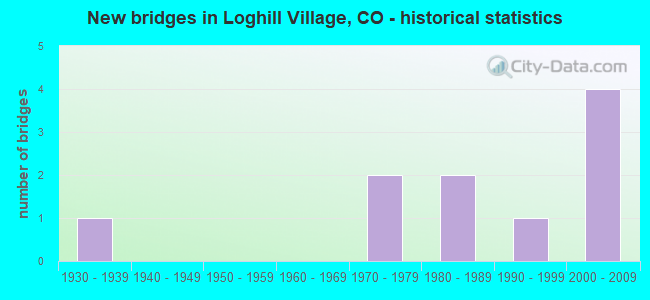
- New bridges - historical statistics
- 11930-1939
- 21970-1979
- 21980-1989
- 11990-1999
- 42000-2009


- Bridge Condition - Deck
- 25.0%Very good
- 25.0%Good
- 37.5%Satisfactory
- 12.5%Poor

- Bridge Condition - Superstructure
- 25.0%Very good
- 37.5%Good
- 25.0%Satisfactory
- 12.5%Fair

- Bridge Condition - Substructure
- 12.5%Very good
- 62.5%Good
- 12.5%Satisfactory
- 12.5%Fair

- Bridge Condition - Channel
- 50.0%Very good
- 10.0%Good
- 20.0%Satisfactory
- 20.0%Fair

- Bridge Condition - Culverts
- 50.0%Satisfactory
- 50.0%Fair
Find on map >> Show street view
Structure Number: K-05-AC, Location: 8.7 MI N OF JCT SH 62 (Lat: 38.263700, Lng: -107.758475), Route carried "on" structure: US 550B, Year Built: 1975, Status: Open, Structure Length: 2.49m (8.17ft), Average Daily Traffic: 8,300 (year 2020), Truck Traffic: 6%, Average Future Daily Traffic: 9,794 (year 2040), Design Load: HS 20, Features Intersected: CHAFFEE GULCH, Facility Carried by Structure: US 550 ML
Minimum Vertical Clearance: 30+ m (98+ ft), Kilometerpoint: 145.977, Lanes on structure: 2, Base Highway Network: Yes, Owner: State Highway Agency, Approaching Roadway Width: 12.8m (42.0ft), Skew: 2 degrees, Material/Design: Prestressed concrete, Design/Construction: Stringer/Multi-beam, Number Of Spans In Main Unit: 1, Length of Maximum Span: 24.0m (78.7ft), Curb-To-Curb Width: 12.8m (42.0ft), Out-to-Out Width: 13.6m (44.6ft)
Condition: Deck: Good, Superstructure: Good, Substructure: Good, Channel: Very good, Operating Rating: 57.8 metric tons, Method Used To Determine Operating Rating: Load Factor (LF), Inventory Rating: 24.8 metric tons, Method Used To Determine Inventory Rating: Load Factor (LF), Structural Evaluation: Equal to present minimum criteria, Deck Geometry: Somewhat better than minimum adequacy, Waterway Adequacy: Equal to present desirable criteria, Approach Roadway Alignment: Equal to present desirable criteria, Designated Inspection Frequency: Every 24 months, Inspection Date: June 2021, Deck Structure Type: Concrete Cast-file-Place, Wearing Surface/Protective System: Wearing Surface: Bituminous
Find on map >> Show street view
Structure Number: K-05-BS, Location: 8 MI OF SH62-RIDGWAY (Lat: 38.267075, Lng: -107.761453), Route carried "on" structure: US 550B, Year Built: 1989, Status: Open, Structure Length: 5.07m (16.63ft), Average Daily Traffic: 8,300 (year 2020), Truck Traffic: 6%, Average Future Daily Traffic: 9,794 (year 2040), Design Load: HS 20, Features Intersected: UNCOMPHAGRE RIVER, Facility Carried by Structure: US 550 ML
Minimum Vertical Clearance: 30+ m (98+ ft), Kilometerpoint: 146.436, Lanes on structure: 2, Base Highway Network: Yes, Owner: State Highway Agency, Approaching Roadway Width: 13.4m (44.0ft), Skew: 2 degrees, Material/Design: Prestressed concrete continuous, Design/Construction: Stringer/Multi-beam, Number Of Spans In Main Unit: 2, Length of Maximum Span: 24.7m (81.0ft), Curb-To-Curb Width: 13.4m (44.0ft), Out-to-Out Width: 14.2m (46.6ft)
Condition: Deck: Very good, Superstructure: Very good, Substructure: Good, Channel: Very good, Operating Rating: 45.6 metric tons, Method Used To Determine Operating Rating: Load Factor (LF), Inventory Rating: 27.3 metric tons, Method Used To Determine Inventory Rating: Load Factor (LF), Structural Evaluation: Equal to present minimum criteria, Deck Geometry: Equal to present minimum criteria, Waterway Adequacy: Equal to present desirable criteria, Approach Roadway Alignment: Equal to present desirable criteria, Designated Inspection Frequency: Every 48 months, Inspection Date: June 2021, Deck Structure Type: Concrete Cast-file-Place, Wearing Surface/Protective System: Wearing Surface: Bituminous, Membrane: Built-up, Deck Protection: Epoxy Coated Reinforcing
Find on map >> Show street view
Structure Number: L-05-C, Location: 7.5 MI NO.OF JCT SH 62 ML (Lat: 38.248042, Lng: -107.758817), Route carried "on" structure: ServiceUS 550B, Year Built: 1938, Status: Posted for load, Structure Length: 2.09m (6.86ft), Average Daily Traffic: 8,300 (year 2020), Truck Traffic: 6%, Average Future Daily Traffic: 9,794 (year 2040), Design Load: H 15, Features Intersected: COW CREEK AR, Facility Carried by Structure: FARM ACCESS TO 550
Minimum Vertical Clearance: 30+ m (98+ ft), Kilometerpoint: 144.192, Lanes on structure: 2, Base Highway Network: Yes, Owner: State Highway Agency, Approaching Roadway Width: 7.9m (25.9ft), Skew: 3 degrees, Material/Design: Steel, Design/Construction: Stringer/Multi-beam, Number Of Spans In Main Unit: 1, Length of Maximum Span: 19.5m (64.0ft), Curb-To-Curb Width: 7.9m (25.9ft), Out-to-Out Width: 10.2m (33.5ft)
Condition: Deck: Poor, Superstructure: Fair, Substructure: Fair, Channel: Fair, Operating Rating: 24.4 metric tons, Method Used To Determine Operating Rating: Load Factor (LF), Inventory Rating: 14.6 metric tons, Method Used To Determine Inventory Rating: Load Factor (LF), Structural Evaluation: High priority of replacement, Deck Geometry: High priority of replacement, Waterway Adequacy: Equal to present desirable criteria, Approach Roadway Alignment: Equal to present desirable criteria, Length Of Structure Improvement: 2.90m (9.51ft), Designated Inspection Frequency: Every 12 months, Inspection Date: April 2021, Bridge Improvement Cost: $471,000, Roadway Improvement Cost: $47,000, Total Project Cost: $706,000 ( Estimate for 2019), Deck Structure Type: Concrete Cast-file-Place, Wearing Surface/Protective System: Wearing Surface: Bituminous
Find on map >> Show street view
Structure Number: L-05-K, Location: 7.7 MI N OF SH 62 (Lat: 38.248214, Lng: -107.759128), Route carried "on" structure: US 550B, Year Built: 1979, Status: Open, Structure Length: 1.46m (4.79ft), Average Daily Traffic: 8,300 (year 2020), Truck Traffic: 6%, Average Future Daily Traffic: 9,794 (year 2040), Design Load: HS 20, Features Intersected: COW CREEK, Facility Carried by Structure: US 550 ML
Minimum Vertical Clearance: 30+ m (98+ ft), Kilometerpoint: 144.208, Lanes on structure: 2, Base Highway Network: Yes, Owner: State Highway Agency, Approaching Roadway Width: 13.4m (44.0ft), Skew: 2 degrees, Material/Design: Concrete, Design/Construction: Culvert, Number Of Spans In Main Unit: 3, Length of Maximum Span: 5.4m (17.7ft), Out-to-Out Width: 43.4m (142.4ft)
Condition: Channel: Satisfactory, Culverts: Fair, Operating Rating: 89.8 metric tons, Method Used To Determine Operating Rating: Field evaluation and documented engineering judgment, Inventory Rating: 89.8 metric tons, Method Used To Determine Inventory Rating: Field evaluation and documented engineering judgment, Structural Evaluation: Somewhat better than minimum adequacy, Waterway Adequacy: Equal to present desirable criteria, Approach Roadway Alignment: Equal to present desirable criteria, Designated Inspection Frequency: Every 24 months, Inspection Date: June 2021
Find on map >> Show street view
Structure Number: L-05-L, Location: 4 MI W OF RIDGWAY (Lat: 38.138414, Lng: -107.818089), Route carried "on" structure: State highway 62A, Year Built: 1980, Status: Open, Structure Length: 0.95m (3.12ft), Average Daily Traffic: 4,000 (year 2020), Truck Traffic: 8%, Average Future Daily Traffic: 4,440 (year 2040), Design Load: HS 20+Mod, Features Intersected: DALLAS CREEK, Facility Carried by Structure: SH 62 ML
Minimum Vertical Clearance: 30+ m (98+ ft), Kilometerpoint: 29.543, Lanes on structure: 2, Base Highway Network: Yes, Owner: State Highway Agency, Approaching Roadway Width: 10.4m (34.1ft), Skew: 4 degrees, Material/Design: Steel, Design/Construction: Culvert, Number Of Spans In Main Unit: 1, Length of Maximum Span: 9.5m (31.2ft), Out-to-Out Width: 26.3m (86.3ft)
Condition: Channel: Satisfactory, Culverts: Satisfactory, Operating Rating: 89.8 metric tons, Method Used To Determine Operating Rating: Load Factor (LF), Inventory Rating: 89.8 metric tons, Method Used To Determine Inventory Rating: Load Factor (LF), Structural Evaluation: Equal to present minimum criteria, Waterway Adequacy: Equal to present desirable criteria, Approach Roadway Alignment: Equal to present desirable criteria, Designated Inspection Frequency: Every 24 months, Inspection Date: June 2021
Find on map >> Show street view
Structure Number: OUR24-1.0-09A, Location: 3.2 MI W OF US 550 (Lat: 38.172167, Lng: -107.795500), Route carried "on" structure: County highway , Year Built: 1999, Status: Open, Structure Length: 0.82m (2.69ft), Average Daily Traffic: 398 (year 2017), Truck Traffic: 2%, Average Future Daily Traffic: 577 (year 2037), Features Intersected: DALLAS CREEK, Facility Carried by Structure: COUNTY ROAD 24
Minimum Vertical Clearance: 30+ m (98+ ft), Kilometerpoint: 10.711, Lanes on structure: 2, Owner: County Highway Agency, Approaching Roadway Width: 7.9m (25.9ft), Skew: 1 degrees, Material/Design: Concrete, Design/Construction: Arch - Deck, Number Of Spans In Main Unit: 1, Length of Maximum Span: 7.7m (25.3ft), Curb-To-Curb Width: 10.6m (34.8ft), Out-to-Out Width: 14.6m (47.9ft)
Condition: Deck: Good, Superstructure: Good, Substructure: Good, Channel: Fair, Operating Rating: 36.3 metric tons, Method Used To Determine Operating Rating: Field evaluation and documented engineering judgment, Inventory Rating: 32.7 metric tons, Method Used To Determine Inventory Rating: Field evaluation and documented engineering judgment, Structural Evaluation: Better than present minimum criteria, Deck Geometry: Better than present minimum criteria, Waterway Adequacy: Equal to present minimum criteria, Approach Roadway Alignment: Equal to present minimum criteria, Designated Inspection Frequency: Every 24 months, Inspection Date: October 2021, Deck Structure Type: Other, Wearing Surface/Protective System: Wearing Surface: Bituminous
Find on map >> Show street view
Structure Number: OUR24-4.1-18, Location: 4 MI W OF US 550 (Lat: 38.163306, Lng: -107.806056), Route carried "on" structure: County highway , Year Built: 2000, Status: Open, Structure Length: 0.91m (2.99ft), Average Daily Traffic: 645 (year 2017), Truck Traffic: 2%, Average Future Daily Traffic: 935 (year 2037), Design Load: HS 20, Features Intersected: DALLAS CREEK, Facility Carried by Structure: COUNTY ROAD 24
Minimum Vertical Clearance: 30+ m (98+ ft), Kilometerpoint: 9.255, Lanes on structure: 2, Owner: County Highway Agency, Approaching Roadway Width: 7.9m (25.9ft), Material/Design: Prestressed concrete, Design/Construction: Slab, Number Of Spans In Main Unit: 1, Length of Maximum Span: 7.9m (25.9ft), Curb-To-Curb Width: 8.5m (27.9ft), Out-to-Out Width: 9.3m (30.5ft)
Condition: Deck: Satisfactory, Superstructure: Satisfactory, Substructure: Good, Channel: Good, Operating Rating: 69.5 metric tons, Method Used To Determine Operating Rating: Load Factor (LF), Inventory Rating: 41.6 metric tons, Method Used To Determine Inventory Rating: Load Factor (LF), Structural Evaluation: Equal to present minimum criteria, Deck Geometry: Somewhat better than minimum adequacy, Waterway Adequacy: Equal to present desirable criteria, Approach Roadway Alignment: Equal to present minimum criteria, Designated Inspection Frequency: Every 24 months, Inspection Date: October 2021, Deck Structure Type: Other, Wearing Surface/Protective System: Wearing Surface: Bituminous, Membrane: Preformed Fabric
Find on map >> Show street view
Structure Number: OUR24-4.7-19, Location: 4.2 MI W OF US 550 (Lat: 38.163278, Lng: -107.817500), Route carried "on" structure: County highway , Year Built: 2000, Status: Open, Structure Length: 0.91m (2.99ft), Average Daily Traffic: 545 (year 2017), Truck Traffic: 2%, Average Future Daily Traffic: 790 (year 2037), Design Load: HS 20, Features Intersected: PLEASANT VALLEY CREEK, Facility Carried by Structure: COUNTY ROAD 24
Minimum Vertical Clearance: 30+ m (98+ ft), Kilometerpoint: 8.235, Lanes on structure: 2, Owner: County Highway Agency, Approaching Roadway Width: 7.9m (25.9ft), Material/Design: Prestressed concrete, Design/Construction: Slab, Number Of Spans In Main Unit: 1, Length of Maximum Span: 7.9m (25.9ft), Curb-To-Curb Width: 8.5m (27.9ft), Out-to-Out Width: 9.3m (30.5ft)
Condition: Deck: Satisfactory, Superstructure: Satisfactory, Substructure: Good, Channel: Very good, Operating Rating: 69.5 metric tons, Method Used To Determine Operating Rating: Load Factor (LF), Inventory Rating: 41.6 metric tons, Method Used To Determine Inventory Rating: Load Factor (LF), Structural Evaluation: Equal to present minimum criteria, Deck Geometry: Somewhat better than minimum adequacy, Waterway Adequacy: Better than present minimum criteria, Approach Roadway Alignment: Better than present minimum criteria, Designated Inspection Frequency: Every 24 months, Inspection Date: October 2021, Deck Structure Type: Other, Wearing Surface/Protective System: Wearing Surface: Bituminous, Membrane: Preformed Fabric
Find on map >> Show street view
Structure Number: OUR24A-0.9-17, Location: 0.2 MI S OF SH 62 (Lat: 38.172361, Lng: -107.778083), Route carried "on" structure: County highway , Year Built: 2000, Status: Open, Structure Length: 1.34m (4.40ft), Average Daily Traffic: 2,096 (year 2017), Truck Traffic: 2%, Average Future Daily Traffic: 3,039 (year 2037), Design Load: HS 20, Features Intersected: DALLAS CREEK, Facility Carried by Structure: COUNTY ROAD 24A
Minimum Vertical Clearance: 30+ m (98+ ft), Kilometerpoint: 1.450, Lanes on structure: 2, Owner: County Highway Agency, Approaching Roadway Width: 7.9m (25.9ft), Material/Design: Steel, Design/Construction: Stringer/Multi-beam, Number Of Spans In Main Unit: 1, Length of Maximum Span: 12.2m (40.0ft), Curb-To-Curb Width: 8.5m (27.9ft), Out-to-Out Width: 8.7m (28.5ft)
Condition: Deck: Very good, Superstructure: Good, Substructure: Satisfactory, Channel: Very good, Operating Rating: 83.5 metric tons, Method Used To Determine Operating Rating: Load Factor (LF), Inventory Rating: 50.1 metric tons, Method Used To Determine Inventory Rating: Load Factor (LF), Structural Evaluation: Equal to present minimum criteria, Deck Geometry: Meets minimum limits, Waterway Adequacy: Better than present minimum criteria, Approach Roadway Alignment: Better than present minimum criteria, Designated Inspection Frequency: Every 24 months, Inspection Date: October 2021, Deck Structure Type: Concrete Cast-file-Place, Wearing Surface/Protective System: Wearing Surface: Bituminous, Membrane: Preformed Fabric
Find on map >> Show street view
Structure Number: OUR8A-0.5-04A, Location: 0.4 MI EAST OF US 550 (Lat: 38.224917, Lng: -107.720306), Route carried "on" structure: County highway , Year Built: 2000, Status: Open, Structure Length: 1.82m (5.97ft), Average Daily Traffic: 85 (year 2017), Average Future Daily Traffic: 123 (year 2037), Design Load: HS 20, Features Intersected: COW CREEK, Facility Carried by Structure: COUNTY ROAD 8A
Minimum Vertical Clearance: 30+ m (98+ ft), Kilometerpoint: 0.698, Lanes on structure: 1, Owner: County Highway Agency, Approaching Roadway Width: 4.9m (16.1ft), Material/Design: Steel, Design/Construction: Stringer/Multi-beam, Number Of Spans In Main Unit: 1, Length of Maximum Span: 16.7m (54.8ft), Curb-To-Curb Width: 4.8m (15.7ft), Out-to-Out Width: 5.6m (18.4ft)
Condition: Deck: Satisfactory, Superstructure: Very good, Substructure: Very good, Channel: Very good, Inventory Rating: 66.1 metric tons, Method Used To Determine Inventory Rating: Load Factor (LF), Structural Evaluation: Equal to present desirable criteria, Deck Geometry: Equal to present desirable criteria, Waterway Adequacy: Equal to present minimum criteria, Approach Roadway Alignment: Equal to present minimum criteria, Designated Inspection Frequency: Every 24 months, Inspection Date: October 2021, Deck Structure Type: Concrete Cast-file-Place, Wearing Surface/Protective System: Wearing Surface: Monolithic Concrete, Deck Protection: Epoxy Coated Reinforcing