Bridge Statistics for Loganville, Pennsylvania (PA)
Condition, Traffic, Stress, Structural Evaluation, Project Costs
- National Bridge Inventory (NBI) Statistics
- 18Number of bridges
- 72ft / 22.1mTotal length
- $3,822,000Total costs
- 256,015Total average daily traffic
- 41,392Total average daily truck traffic
- National Bridge Inventory (NBI) Registered Bridges for Loganville
- No street view available for this location
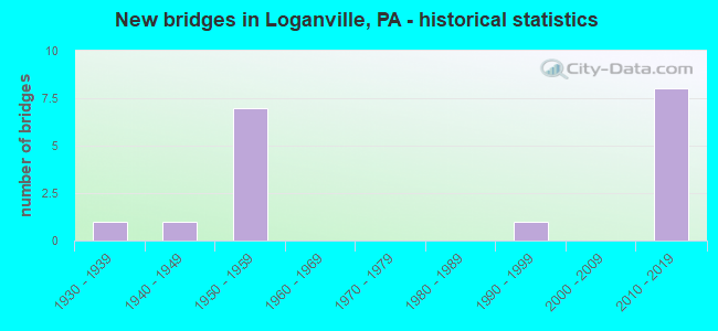
- New bridges - historical statistics
- 11930-1939
- 11940-1949
- 71950-1959
- 11990-1999
- 82010-2019


- Bridge Condition - Deck
- 55.6%Good
- 22.2%Satisfactory
- 22.2%Fair

- Bridge Condition - Superstructure
- 44.4%Very good
- 11.1%Satisfactory
- 33.3%Fair
- 11.1%Poor

- Bridge Condition - Substructure
- 11.1%Very good
- 33.3%Good
- 11.1%Satisfactory
- 44.4%Fair

- Bridge Condition - Channel
- 28.6%Very good
- 14.3%Good
- 28.6%Satisfactory
- 14.3%Fair
- 14.3%Poor
Find on map >> Show street view
Structure Number: 37411, Location: 4 MI.E. OF GLEN ROCK (Lat: 39.827158, Lng: -76.684442), Route carried "on" structure: Interstate 83, Year Built: 1958, Status: Open, Structure Length: 1.04m (3.41ft), Average Daily Traffic: 47,106 (year 2022), Truck Traffic: 17%, Average Future Daily Traffic: 51,767 (year 2032), Design Load: HS 20, Features Intersected: 216 Seaks Run Rd
Minimum Vertical Clearance: 30+ m (98+ ft), Kilometerpoint: 12.117, Lanes on structure: 4, Lanes under structure: 2, Base Highway Network: Yes, Owner: State Highway Agency, Approaching Roadway Width: 26.8m (87.9ft), Skew: 30 degrees, Material/Design: Concrete, Design/Construction: Tee Beam, Number Of Spans In Main Unit: 1, Length of Maximum Span: 9.4m (30.8ft), Curb or Sidewalk Widths: Left: 0.2m (0.7ft), Right: 0.2m (0.7ft), Curb-To-Curb Width: 25.0m (82.0ft), Out-to-Out Width: 26.7m (87.6ft)
Condition: Deck: Fair, Superstructure: Fair, Substructure: Fair, Operating Rating: 84.4 metric tons, Method Used To Determine Operating Rating: Load Factor (LF), Inventory Rating: 49.9 metric tons, Method Used To Determine Inventory Rating: Load Factor (LF), Structural Evaluation: Somewhat better than minimum adequacy, Deck Geometry: Superior to present desirable criteria, Underclear: Better than present minimum criteria, Approach Roadway Alignment: Better than present minimum criteria, Length Of Structure Improvement: 1.70m (5.58ft), Designated Inspection Frequency: Every 24 months, Inspection Date: July 2021, Bridge Improvement Cost: $22,000, Roadway Improvement Cost: $64,000, Total Project Cost: $292,000, Deck Structure Type: Concrete Cast-file-Place, Wearing Surface/Protective System: Wearing Surface: Latex Concrete
Find on map >> Show street view
Structure Number: 37414, Location: 1 MI.E. OF LOGANVILLE (Lat: 39.857014, Lng: -76.691225), Route carried "on" structure: Interstate 83, Year Built: 1958, Status: Open, Structure Length: 3.11m (10.20ft), Average Daily Traffic: 47,106 (year 2022), Truck Traffic: 17%, Average Future Daily Traffic: 51,767 (year 2035), Design Load: HS 20, Features Intersected: PA 214; SR 0214
Minimum Vertical Clearance: 30+ m (98+ ft), Kilometerpoint: 15.292, Lanes on structure: 4, Lanes under structure: 2, Base Highway Network: Yes, Owner: State Highway Agency, Approaching Roadway Width: 25.6m (84.0ft), Skew: 30 degrees, Material/Design: Steel continuous, Design/Construction: Stringer/Multi-beam, Number Of Spans In Main Unit: 3, Length of Maximum Span: 11.0m (36.1ft), Curb or Sidewalk Widths: Left: 0.2m (0.7ft), Right: 0.2m (0.7ft), Curb-To-Curb Width: 25.2m (82.7ft), Out-to-Out Width: 26.7m (87.6ft)
Condition: Deck: Good, Superstructure: Fair, Substructure: Satisfactory, Operating Rating: 77.1 metric tons, Method Used To Determine Operating Rating: Load Factor (LF), Inventory Rating: 46.3 metric tons, Method Used To Determine Inventory Rating: Load Factor (LF), Structural Evaluation: Somewhat better than minimum adequacy, Deck Geometry: Superior to present desirable criteria, Underclear: Meets minimum limits, Approach Roadway Alignment: Equal to present desirable criteria, Length Of Structure Improvement: 3.90m (12.80ft), Designated Inspection Frequency: Every 24 months, Inspection Date: September 2021, Bridge Improvement Cost: $211,000, Roadway Improvement Cost: $622,000, Total Project Cost: $2,850,000, Deck Structure Type: Concrete Cast-file-Place, Wearing Surface/Protective System: Wearing Surface: Monolithic Concrete, Membrane: Preformed Fabric, Deck Protection: Epoxy Coated Reinforcing
Find on map >> Show street view
Structure Number: 37415, Location: 1 MI.E. OF LOGANVILLE (Lat: 39.857781, Lng: -76.691428), Route carried "on" structure: Interstate 83, Year Built: 1958, Status: Open, Structure Length: 0.76m (2.49ft), Average Daily Traffic: 47,106 (year 2022), Truck Traffic: 17%, Average Future Daily Traffic: 51,767 (year 2032), Design Load: HS 20, Features Intersected: TRIB OF E BR CODORUS CRK
Minimum Vertical Clearance: 30+ m (98+ ft), Kilometerpoint: 15.292, Lanes on structure: 4, Base Highway Network: Yes, Owner: State Highway Agency, Approaching Roadway Width: 25.6m (84.0ft), Skew: 31 degrees, Material/Design: Concrete, Design/Construction: Culvert, Number Of Spans In Main Unit: 1, Length of Maximum Span: 7.6m (24.9ft)
Condition: Channel: Very good, Culverts: Satisfactory, Operating Rating: 63.5 metric tons, Method Used To Determine Operating Rating: Allowable Stress (AS), Inventory Rating: 42.6 metric tons, Method Used To Determine Inventory Rating: Allowable Stress (AS), Structural Evaluation: Equal to present minimum criteria, Waterway Adequacy: Superior to present desirable criteria, Approach Roadway Alignment: Equal to present desirable criteria, Length Of Structure Improvement: 1.50m (4.92ft), Designated Inspection Frequency: Every 24 months, Inspection Date: July 2021
Find on map >> Show street view
Structure Number: 37527, Location: .5 MI. E. LOGANVILLE (Lat: 39.856956, Lng: -76.692144), Route carried "on" structure: State highway 214, Year Built: 1958, Status: Open, Structure Length: 0.76m (2.49ft), Average Daily Traffic: 2,548 (year 2020), Truck Traffic: 8%, Average Future Daily Traffic: 2,556 (year 2032), Design Load: HS 20, Features Intersected: TRIB E BR CODORUS CR
Minimum Vertical Clearance: 30+ m (98+ ft), Kilometerpoint: 10.424, Lanes on structure: 2, Owner: State Highway Agency, Approaching Roadway Width: 7.3m (24.0ft), Skew: 3 degrees, Material/Design: Concrete, Design/Construction: Culvert, Number Of Spans In Main Unit: 1, Length of Maximum Span: 7.6m (24.9ft)
Condition: Channel: Satisfactory, Culverts: Satisfactory, Operating Rating: 69.9 metric tons, Method Used To Determine Operating Rating: Allowable Stress (AS), Inventory Rating: 46.3 metric tons, Method Used To Determine Inventory Rating: Allowable Stress (AS), Structural Evaluation: Equal to present minimum criteria, Waterway Adequacy: Superior to present desirable criteria, Approach Roadway Alignment: Equal to present desirable criteria, Length Of Structure Improvement: 1.50m (4.92ft), Designated Inspection Frequency: Every 24 months, Inspection Date: August 2021
Find on map >> Show street view
Structure Number: 37548, Location: 2 MILE SE OF LOGANVILLE (Lat: 39.831161, Lng: -76.676558), Route carried "on" structure: State highway 216, Year Built: 1992, Status: Open, Structure Length: 0.82m (2.69ft), Average Daily Traffic: 932 (year 2022), Truck Traffic: 12%, Average Future Daily Traffic: 1,240 (year 2032), Design Load: HS 25 or greater, Features Intersected: SEAKS RUN
Minimum Vertical Clearance: 30+ m (98+ ft), Kilometerpoint: 34.144, Lanes on structure: 2, Owner: State Highway Agency, Approaching Roadway Width: 8.5m (27.9ft), Skew: 3 degrees, Material/Design: Prestressed concrete, Design/Construction: Box Beam or Girders - Single/Spread, Number Of Spans In Main Unit: 1, Length of Maximum Span: 7.6m (24.9ft), Curb or Sidewalk Widths: Left: 0.2m (0.7ft), Right: 0.2m (0.7ft), Curb-To-Curb Width: 8.5m (27.9ft), Out-to-Out Width: 9.6m (31.5ft)
Condition: Deck: Good, Superstructure: Very good, Substructure: Good, Channel: Good, Operating Rating: 84.4 metric tons, Method Used To Determine Operating Rating: Load Factor (LF), Inventory Rating: 51.7 metric tons, Method Used To Determine Inventory Rating: Load Factor (LF), Structural Evaluation: Better than present minimum criteria, Deck Geometry: Somewhat better than minimum adequacy, Waterway Adequacy: Better than present minimum criteria, Approach Roadway Alignment: Equal to present desirable criteria, Length Of Structure Improvement: 1.40m (4.59ft), Designated Inspection Frequency: Every 48 months, Inspection Date: July 2021, Deck Structure Type: Concrete Cast-file-Place, Wearing Surface/Protective System: Wearing Surface: Monolithic Concrete, Deck Protection: Epoxy Coated Reinforcing
Find on map >> Show street view
Structure Number: 37549, Location: 4 MILE W OF WINTERSTOWN (Lat: 39.837392, Lng: -76.670631), Route carried "on" structure: State highway 216, Year Built: 1948, Status: Open, Structure Length: 0.82m (2.69ft), Average Daily Traffic: 932 (year 2022), Truck Traffic: 12%, Average Future Daily Traffic: 1,240 (year 2032), Features Intersected: SEAKS RUN
Minimum Vertical Clearance: 30+ m (98+ ft), Kilometerpoint: 35.690, Lanes on structure: 2, Owner: State Highway Agency, Approaching Roadway Width: 6.4m (21.0ft), Skew: 3 degrees, Material/Design: Concrete, Design/Construction: Slab, Number Of Spans In Main Unit: 1, Length of Maximum Span: 7.3m (24.0ft), Curb or Sidewalk Widths: Left: 0.3m (1.0ft), Right: 0.3m (1.0ft), Curb-To-Curb Width: 7.3m (24.0ft), Out-to-Out Width: 8.4m (27.6ft)
Condition: Deck: Satisfactory, Superstructure: Satisfactory, Substructure: Fair, Channel: Fair, Operating Rating: 49.0 metric tons, Method Used To Determine Operating Rating: Field evaluation and documented engineering judgment, Inventory Rating: 32.7 metric tons, Method Used To Determine Inventory Rating: Field evaluation and documented engineering judgment, Structural Evaluation: Somewhat better than minimum adequacy, Deck Geometry: Meets minimum limits, Waterway Adequacy: Better than present minimum criteria, Approach Roadway Alignment: Equal to present desirable criteria, Length Of Structure Improvement: 1.40m (4.59ft), Designated Inspection Frequency: Every 24 months, Inspection Date: July 2021, Wearing Surface/Protective System: Wearing Surface: Bituminous
Find on map >> Show street view
Structure Number: 3781, Location: 2 MILE EAST OF LOGANVILLE (Lat: 39.872036, Lng: -76.678594), Route carried "on" structure: State highway , Year Built: 1934, Status: Open, Structure Length: 1.98m (6.50ft), Average Daily Traffic: 526 (year 2022), Truck Traffic: 9%, Average Future Daily Traffic: 1,186 (year 2032), Design Load: H 20, Features Intersected: EAST BRANCH CODORUS CR, Facility Carried by Structure: SR 2087
Minimum Vertical Clearance: 30+ m (98+ ft), Kilometerpoint: 0.884, Lanes on structure: 2, Owner: State Highway Agency, Approaching Roadway Width: 5.5m (18.0ft), Skew: 3 degrees, Material/Design: Steel, Design/Construction: Stringer/Multi-beam, Number Of Spans In Main Unit: 1, Length of Maximum Span: 18.3m (60.0ft), Curb-To-Curb Width: 6.7m (22.0ft), Out-to-Out Width: 7.6m (24.9ft)
Condition: Deck: Fair, Superstructure: Fair, Substructure: Fair, Channel: Satisfactory, Operating Rating: 40.8 metric tons, Method Used To Determine Operating Rating: Load Factor (LF), Inventory Rating: 24.5 metric tons, Method Used To Determine Inventory Rating: Load Factor (LF), Structural Evaluation: Somewhat better than minimum adequacy, Deck Geometry: Meets minimum limits, Waterway Adequacy: Better than present minimum criteria, Approach Roadway Alignment: Better than present minimum criteria, Length Of Structure Improvement: 2.70m (8.86ft), Designated Inspection Frequency: Every 24 months, Underwater Inspection Frequency: Every 24 months, Inspection Date: July 2021, Underwater Inspection Date: April 2020, Bridge Improvement Cost: $44,000, Roadway Improvement Cost: $128,000, Total Project Cost: $588,000, Deck Structure Type: Concrete Cast-file-Place, Wearing Surface/Protective System: Wearing Surface: Bituminous
Find on map >> Show street view
Structure Number: 38037, Location: @ LK.REDMAN/E.BR.CODORUS (Lat: 39.875661, Lng: -76.684056), Route carried "on" structure: City street , Year Built: 1954, Year Reconstructed: 1984, Status: Posted for load, Structure Length: 0.98m (3.22ft), Average Daily Traffic: 1,288 (year 2012), Truck Traffic: 5%, Average Future Daily Traffic: 313 (year 2032), Design Load: HS 20, Features Intersected: EAST BRANCH CODORUS CR, Facility Carried by Structure: LOG ROAD
Minimum Vertical Clearance: 30+ m (98+ ft), Kilometerpoint: 0.000, Lanes on structure: 1, Owner: County Highway Agency, Approaching Roadway Width: 5.5m (18.0ft), Material/Design: Prestressed concrete, Design/Construction: Box Beam or Girders - Multiple, Number Of Spans In Main Unit: 1, Length of Maximum Span: 8.8m (28.9ft), Curb or Sidewalk Widths: Left: 0.2m (0.7ft), Right: 0.2m (0.7ft), Curb-To-Curb Width: 5.1m (16.7ft), Out-to-Out Width: 5.5m (18.0ft)
Condition: Deck: Satisfactory, Superstructure: Poor, Substructure: Fair, Channel: Poor, Operating Rating: 20.0 metric tons, Method Used To Determine Operating Rating: Load Factor (LF), Inventory Rating: 8.2 metric tons, Method Used To Determine Inventory Rating: Load Factor (LF), Structural Evaluation: High priority of corrective action, Deck Geometry: High priority of replacement, Waterway Adequacy: Equal to present minimum criteria, Approach Roadway Alignment: Equal to present minimum criteria, Bridge Posting: Required (Relationship of Operating Rating to Maximum Legal Load: > 39.9% below), Length Of Structure Improvement: 1.60m (5.25ft), Designated Inspection Frequency: Every 24 months, Other Special Inspection Frequency: Every 6 months, Inspection Date: May 2021, Other Special Inspection Date: May 2021, Bridge Improvement Cost: $7,000, Roadway Improvement Cost: $20,000, Total Project Cost: $92,000, Deck Structure Type: Concrete Cast-file-Place, Wearing Surface/Protective System: Wearing Surface: Monolithic Concrete, Deck Protection: Epoxy Coated Reinforcing
Find on map >> Show street view
Structure Number: 45835, Location: JOCOBUS (Lat: 39.862278, Lng: -76.710683), Route carried "on" structure: State highway 214, Year Built: 2010, Status: Open, Structure Length: 1.34m (4.40ft), Average Daily Traffic: 4,022 (year 2020), Truck Traffic: 5%, Average Future Daily Traffic: 2,641 (year 2032), Design Load: HL 93, Features Intersected: Trib Codorus Ck/ WaterSt
Minimum Vertical Clearance: 30+ m (98+ ft), Kilometerpoint: 7.804, Lanes on structure: 2, Lanes under structure: 2, Owner: State Highway Agency, Approaching Roadway Width: 7.3m (24.0ft), Skew: 2 degrees, Material/Design: Prestressed concrete, Design/Construction: Box Beam or Girders - Single/Spread, Number Of Spans In Main Unit: 1, Length of Maximum Span: 12.2m (40.0ft), Curb or Sidewalk Widths: Left: 0.0m, Right: 3.0m (9.8ft), Curb-To-Curb Width: 12.8m (42.0ft), Out-to-Out Width: 16.2m (53.1ft)
Condition: Deck: Good, Superstructure: Very good, Substructure: Good, Channel: Very good, Operating Rating: 52.6 metric tons, Method Used To Determine Operating Rating: Load and Resistance Factor (LRFR), Inventory Rating: 39.0 metric tons, Method Used To Determine Inventory Rating: Load and Resistance Factor (LRFR), Structural Evaluation: Better than present minimum criteria, Deck Geometry: Equal to present minimum criteria, Underclear: Equal to present minimum criteria, Waterway Adequacy: Superior to present desirable criteria, Approach Roadway Alignment: Equal to present desirable criteria, Designated Inspection Frequency: Every 48 months, Inspection Date: August 2019, Deck Structure Type: Concrete Cast-file-Place, Wearing Surface/Protective System: Wearing Surface: Monolithic Concrete, Deck Protection: Epoxy Coated Reinforcing
Find on map >> Show street view
Structure Number: 4646, Location: 1 mi SE of Loganville (Lat: 39.844533, Lng: -76.688367), Route carried "on" structure: State highway , Year Built: 2010, Status: Open, Structure Length: 6.16m (20.21ft), Average Daily Traffic: 1,014 (year 2021), Truck Traffic: 13%, Average Future Daily Traffic: 979 (year 2032), Design Load: HL 93, Features Intersected: I-83 NB & SB, Facility Carried by Structure: Ridge View Road
Minimum Vertical Clearance: 30+ m (98+ ft), Kilometerpoint: 1.439, Lanes on structure: 2, Lanes under structure: 4, Owner: State Highway Agency, Approaching Roadway Width: 9.1m (29.9ft), Skew: 1 degrees, Material/Design: Prestressed concrete, Design/Construction: Box Beam or Girders - Single/Spread, Number Of Spans In Main Unit: 2, Length of Maximum Span: 30.5m (100.1ft), Curb or Sidewalk Widths: Left: 0.2m (0.7ft), Right: 0.2m (0.7ft), Curb-To-Curb Width: 9.1m (29.9ft), Out-to-Out Width: 10.2m (33.5ft)
Condition: Deck: Good, Superstructure: Very good, Substructure: Very good, Operating Rating: 71.7 metric tons, Method Used To Determine Operating Rating: Load and Resistance Factor (LRFR), Inventory Rating: 41.7 metric tons, Method Used To Determine Inventory Rating: Load and Resistance Factor (LRFR), Structural Evaluation: Equal to present desirable criteria, Deck Geometry: Somewhat better than minimum adequacy, Underclear: High priority of corrective action, Approach Roadway Alignment: Better than present minimum criteria, Designated Inspection Frequency: Every 24 months, Inspection Date: October 2019, Deck Structure Type: Concrete Cast-file-Place, Wearing Surface/Protective System: Wearing Surface: Monolithic Concrete, Deck Protection: Epoxy Coated Reinforcing
Find on map >> Show street view
Structure Number: 48471, Location: 1 MI. NE OF LOGANVILLE (Lat: 39.865836, Lng: -76.697944), Route carried "on" structure: Spur State highway , Year Built: 2014, Status: Open, Structure Length: 4.33m (14.21ft), Average Daily Traffic: 5,743 (year 2022), Truck Traffic: 3%, Average Future Daily Traffic: 9,030 (year 2032), Design Load: HL 93, Features Intersected: I-83, Facility Carried by Structure: 3100/North Street
Minimum Vertical Clearance: 30+ m (98+ ft), Kilometerpoint: 0.406, Lanes on structure: 2, Lanes under structure: 8, Owner: State Highway Agency, Approaching Roadway Width: 11.6m (38.1ft), Material/Design: Prestressed concrete continuous, Design/Construction: Stringer/Multi-beam, Number Of Spans In Main Unit: 2, Length of Maximum Span: 21.6m (70.9ft), Curb or Sidewalk Widths: Left: 0.2m (0.7ft), Right: 3.0m (9.8ft), Curb-To-Curb Width: 13.1m (43.0ft), Out-to-Out Width: 17.5m (57.4ft)
Condition: Deck: Good, Superstructure: Very good, Substructure: Good, Operating Rating: 56.7 metric tons, Method Used To Determine Operating Rating: Assigned ratings based on Load and Resistance Factor Design (LRFD) reported by rating factor (RF) using HL93 loadings, Inventory Rating: 35.6 metric tons, Method Used To Determine Inventory Rating: Assigned ratings based on Load and Resistance Factor Design (LRFD) reported by rating factor (RF) using HL93 loadings, Structural Evaluation: Better than present minimum criteria, Deck Geometry: Somewhat better than minimum adequacy, Underclear: Better than present minimum criteria, Approach Roadway Alignment: Equal to present desirable criteria, Designated Inspection Frequency: Every 24 months, Inspection Date: October 2019, Deck Structure Type: Concrete Cast-file-Place, Wearing Surface/Protective System: Wearing Surface: Latex Concrete, Deck Protection: Epoxy Coated Reinforcing
Find on map >> Show street view
Structure Number: 37411, Location: 4 MI.E. OF GLEN ROCK (Lat: 39.827158, Lng: -76.684442), Route carried "under" structure: State highway 216, Year Built: 1958, Structure Length: 0. m, Average Daily Traffic: 932 (year 2022), Truck Traffic: 12%, Features Intersected: 216 Seaks Run Rd, Facility Carried by Structure: I-83 Veteran's Hwy
Minimum Vertical Clearance: 4.75m (15.58ft), Kilometerpoint: 33.352, Lanes on structure: 4, Lanes under structure: 2, Material/Design: Concrete, Design/Construction: Tee Beam, Length of Maximum Span: 9.4m (30.8ft)
Find on map >> Show street view
Structure Number: 37414, Location: 1 MI.E. OF LOGANVILLE (Lat: 39.857014, Lng: -76.691225), Route carried "under" structure: State highway 214, Year Built: 1958, Structure Length: 0. m, Average Daily Traffic: 2,548 (year 2020), Truck Traffic: 8%, Features Intersected: PA 214; SR 0214, Facility Carried by Structure: I-83; SR 0083
Minimum Vertical Clearance: 4.80m (15.75ft), Kilometerpoint: 10.424, Lanes on structure: 4, Lanes under structure: 2, Material/Design: Steel continuous, Design/Construction: Stringer/Multi-beam, Length of Maximum Span: 11.0m (36.1ft)
Find on map >> Show street view
Structure Number: 45835, Location: JOCOBUS (Lat: 39.862278, Lng: -76.710683), Route carried "under" structure: City street , Year Built: 2010, Structure Length: 0. m, Features Intersected: Trib Codorus Ck/ WaterSt, Facility Carried by Structure: SR0214
Minimum Vertical Clearance: 30+ m (98+ ft), Kilometerpoint: 0.000, Lanes on structure: 2, Lanes under structure: 2, Material/Design: Prestressed concrete, Design/Construction: Box Beam or Girders - Single/Spread, Length of Maximum Span: 12.2m (40.0ft)
Find on map >> Show street view
Structure Number: 4646, Location: 1 mi SE of Loganville (Lat: 39.844533, Lng: -76.688367), Route carried "under" structure: Interstate 83, Year Built: 2010, Structure Length: 0. m, Average Daily Traffic: 23,503 (year 2022), Truck Traffic: 17%, Features Intersected: I-83 NB & SB, Facility Carried by Structure: Ridge View Road
Minimum Vertical Clearance: 5.33m (17.49ft), Kilometerpoint: 13.683, Lanes on structure: 2, Lanes under structure: 2, Material/Design: Prestressed concrete, Design/Construction: Box Beam or Girders - Single/Spread, Length of Maximum Span: 30.5m (100.1ft)
Find on map >> Show street view
Structure Number: 4646, Location: 1 mi SE of Loganville (Lat: 39.844533, Lng: -76.688367), Route carried "under" structure: Interstate 83, Year Built: 2010, Structure Length: 0. m, Average Daily Traffic: 23,603 (year 2022), Truck Traffic: 17%, Features Intersected: I-83 NB & SB, Facility Carried by Structure: Ridge View Road
Minimum Vertical Clearance: 5.51m (18.08ft), Kilometerpoint: 13.689, Lanes on structure: 2, Lanes under structure: 2, Material/Design: Prestressed concrete, Design/Construction: Box Beam or Girders - Single/Spread, Length of Maximum Span: 30.5m (100.1ft)
Find on map >> Show street view
Structure Number: 48471, Location: 1 MI. NE OF LOGANVILLE (Lat: 39.865836, Lng: -76.697944), Route carried "under" structure: Interstate 83, Year Built: 2014, Structure Length: 0. m, Average Daily Traffic: 23,503 (year 2022), Truck Traffic: 17%, Features Intersected: I-83, Facility Carried by Structure: 3100/North Street
Minimum Vertical Clearance: 5.21m (17.09ft), Kilometerpoint: 16.097, Lanes on structure: 2, Lanes under structure: 4, Material/Design: Prestressed concrete continuous, Design/Construction: Stringer/Multi-beam, Length of Maximum Span: 21.6m (70.9ft)
Find on map >> Show street view
Structure Number: 48471, Location: 1 MI. NE OF LOGANVILLE (Lat: 39.865836, Lng: -76.697944), Route carried "under" structure: Interstate 83, Year Built: 2014, Structure Length: 0. m, Average Daily Traffic: 23,603 (year 2022), Truck Traffic: 17%, Features Intersected: I-83, Facility Carried by Structure: 3100/North Street
Minimum Vertical Clearance: 5.21m (17.09ft), Kilometerpoint: 16.093, Lanes on structure: 2, Lanes under structure: 4, Material/Design: Prestressed concrete continuous, Design/Construction: Stringer/Multi-beam, Length of Maximum Span: 21.6m (70.9ft)