Bridge Statistics for Logan, West Virginia (WV)
Condition, Traffic, Stress, Structural Evaluation, Project Costs
- National Bridge Inventory (NBI) Statistics
- 16Number of bridges
- 456ft / 139mTotal length
- $13,771,000Total costs
- 103,565Total average daily traffic
- 9,809Total average daily truck traffic
- National Bridge Inventory (NBI) Registered Bridges for Logan
- No street view available for this location
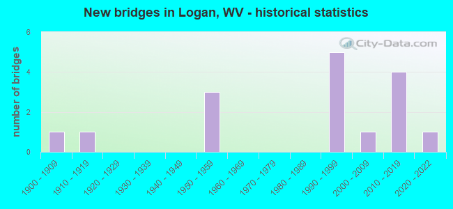
- New bridges - historical statistics
- 11900-1909
- 11910-1919
- 31950-1959
- 51990-1999
- 12000-2009
- 42010-2019
- 12020-2022


- Bridge Condition - Deck
- 10.0%Very good
- 80.0%Satisfactory
- 10.0%Poor

- Bridge Condition - Superstructure
- 9.1%Very good
- 36.4%Good
- 18.2%Satisfactory
- 18.2%Fair
- 18.2%Poor

- Bridge Condition - Substructure
- 9.1%Very good
- 9.1%Good
- 45.5%Satisfactory
- 9.1%Fair
- 27.3%Poor

- Bridge Condition - Channel
- 9.1%Very good
- 81.8%Good
- 9.1%Poor
Find on map >> Show street view
Structure Number: 23A04, Location: 0.01 MI NORTH OF WV 73 (Lat: 37.847600, Lng: -81.999219), Route carried "on" structure: State highway 1000, Year Built: 1953, Year Reconstructed: 1990, Status: Posted for load, Structure Length: 20.54m (67.39ft), Average Daily Traffic: 9,800 (year 2018), Truck Traffic: 8%, Average Future Daily Traffic: 17,052 (year 2038), Design Load: HS 15, Features Intersected: ISLAND CK,CR 119/26, CSX, Facility Carried by Structure: WV 10
Minimum Vertical Clearance: 30+ m (98+ ft), Kilometerpoint: 35.502, Lanes on structure: 2, Lanes under structure: 2, Base Highway Network: Yes, Owner: State Highway Agency, Approaching Roadway Width: 13.4m (44.0ft), Skew: 1 degrees, Material/Design: Steel continuous, Design/Construction: Stringer/Multi-beam, Number Of Spans In Main Unit: 3, Number Of Approach Spans: 8, Length of Maximum Span: 26.5m (86.9ft), Curb or Sidewalk Widths: Left: 0.0m, Right: 1.8m (5.9ft), Curb-To-Curb Width: 8.5m (27.9ft), Out-to-Out Width: 11.1m (36.4ft)
Condition: Deck: Satisfactory, Superstructure: Satisfactory, Substructure: Poor, Channel: Good, Operating Rating: 58.0 metric tons, Method Used To Determine Operating Rating: Load Factor (LF), Inventory Rating: 34.5 metric tons, Method Used To Determine Inventory Rating: Load Factor (LF), Structural Evaluation: Meets minimum limits, Deck Geometry: Meets minimum limits, Underclear: Meets minimum limits, Waterway Adequacy: Equal to present minimum criteria, Approach Roadway Alignment: Equal to present minimum criteria, Length Of Structure Improvement: 20.57m (67.49ft), Designated Inspection Frequency: Every 24 months, Inspection Date: July 2020, Bridge Improvement Cost: $2,184,000, Roadway Improvement Cost: $1,965,000, Total Project Cost: $4,649,000 ( Estimate for 2018), Deck Structure Type: Concrete Cast-file-Place, Wearing Surface/Protective System: Wearing Surface: Monolithic Concrete
Find on map >> Show street view
Structure Number: 23A15, Location: 0.12 MI WEST OF CR 5 (Lat: 37.845211, Lng: -82.008861), Route carried "on" structure: County highway 11926, Year Built: 1917, Status: Posted for load, Structure Length: 3.90m (12.80ft), Average Daily Traffic: 2,600 (year 2018), Truck Traffic: 6%, Average Future Daily Traffic: 3,432 (year 2038), Features Intersected: ISLAND CREEK, Facility Carried by Structure: CR 119/26
Minimum Vertical Clearance: 30+ m (98+ ft), Kilometerpoint: 0.531, Lanes on structure: 2, Owner: State Highway Agency, Approaching Roadway Width: 6.4m (21.0ft), Material/Design: Concrete, Design/Construction: Arch - Deck, Number Of Spans In Main Unit: 2, Length of Maximum Span: 17.4m (57.1ft), Curb-To-Curb Width: 4.9m (16.1ft), Out-to-Out Width: 5.4m (17.7ft)
Condition: Superstructure: Poor, Substructure: Poor, Channel: Poor, Operating Rating: 24.5 metric tons, Method Used To Determine Operating Rating: Field evaluation and documented engineering judgment, Inventory Rating: 10.0 metric tons, Method Used To Determine Inventory Rating: Field evaluation and documented engineering judgment, Structural Evaluation: High priority of replacement, Deck Geometry: High priority of replacement, Waterway Adequacy: Somewhat better than minimum adequacy, Approach Roadway Alignment: Somewhat better than minimum adequacy, Bridge Posting: Required (Relationship of Operating Rating to Maximum Legal Load: 10.0 - 19.9% below), Length Of Structure Improvement: 3.96m (12.99ft), Designated Inspection Frequency: Every 24 months, Underwater Inspection Frequency: Every 60 months, Inspection Date: April 2020, Underwater Inspection Date: July 2020, Bridge Improvement Cost: $352,000, Roadway Improvement Cost: $34,000, Total Project Cost: $422,000 ( Estimate for 2016), Deck Structure Type: Concrete Cast-file-Place, Wearing Surface/Protective System: Wearing Surface: Bituminous
Find on map >> Show street view
Structure Number: 23A209, Location: 0.01 MI WEST OF US 119 (Lat: 37.846731, Lng: -82.010731), Route carried "on" structure: State highway 7300, Year Built: 1994, Status: Open, Structure Length: 18.99m (62.30ft), Average Daily Traffic: 8,600 (year 2020), Truck Traffic: 6%, Average Future Daily Traffic: 9,030 (year 2040), Design Load: HS 25 or greater, Features Intersected: RT 5, 119/14, RR, MUD FK, Facility Carried by Structure: WV 73
Minimum Vertical Clearance: 30+ m (98+ ft), Kilometerpoint: 3.460, Lanes on structure: 5, Lanes under structure: 2, Base Highway Network: Yes, Owner: State Highway Agency, Approaching Roadway Width: 30.5m (100.1ft), Skew: 22 degrees, Material/Design: Prestressed concrete continuous, Design/Construction: Box Beam or Girders - Multiple, Number Of Spans In Main Unit: 2, Number Of Approach Spans: 4, Length of Maximum Span: 35.1m (115.2ft), Curb-To-Curb Width: 27.4m (89.9ft), Out-to-Out Width: 28.1m (92.2ft)
Condition: Deck: Satisfactory, Superstructure: Fair, Substructure: Fair, Channel: Good, Operating Rating: 55.3 metric tons, Method Used To Determine Operating Rating: Load Factor (LF), Inventory Rating: 32.7 metric tons, Method Used To Determine Inventory Rating: Load Factor (LF), Structural Evaluation: Somewhat better than minimum adequacy, Deck Geometry: Superior to present desirable criteria, Underclear: High priority of replacement, Waterway Adequacy: Equal to present minimum criteria, Approach Roadway Alignment: Better than present minimum criteria, Length Of Structure Improvement: 18.99m (62.30ft), Designated Inspection Frequency: Every 24 months, Other Special Inspection Frequency: Every 12 months, Inspection Date: September 2021, Other Special Inspection Date: September 2021, Bridge Improvement Cost: $6,000,000, Roadway Improvement Cost: $500,000, Total Project Cost: $6,500,000 ( Estimate for 2018), Deck Structure Type: Concrete Cast-file-Place, Wearing Surface/Protective System: Wearing Surface: Integral Concrete, Deck Protection: Epoxy Coated Reinforcing
Find on map >> Show street view
Structure Number: 23A257, Location: 0.01 MILE WEST OF WV 10 (Lat: 37.842689, Lng: -81.975119), Route carried "on" structure: County highway 1073, Year Built: 1997, Status: Open, Structure Length: 9.80m (32.15ft), Average Daily Traffic: 10 (year 2016), Truck Traffic: 6%, Average Future Daily Traffic: 12 (year 2036), Design Load: HS 25 or greater, Features Intersected: GUYANDOTTE RIVER, Facility Carried by Structure: CR 10/73
Minimum Vertical Clearance: 30+ m (98+ ft), Kilometerpoint: 0.016, Lanes on structure: 2, Owner: State Highway Agency, Approaching Roadway Width: 7.6m (24.9ft), Material/Design: Steel continuous, Design/Construction: Stringer/Multi-beam, Number Of Spans In Main Unit: 1, Number Of Approach Spans: 2, Length of Maximum Span: 37.5m (123.0ft), Curb or Sidewalk Widths: Left: 1.4m (4.6ft), Right: 0.0m, Curb-To-Curb Width: 7.7m (25.3ft), Out-to-Out Width: 10.1m (33.1ft)
Condition: Deck: Satisfactory, Superstructure: Good, Substructure: Satisfactory, Channel: Good, Operating Rating: 88.9 metric tons, Method Used To Determine Operating Rating: Load Factor (LF), Inventory Rating: 55.3 metric tons, Method Used To Determine Inventory Rating: Load Factor (LF), Structural Evaluation: Equal to present minimum criteria, Deck Geometry: Equal to present minimum criteria, Waterway Adequacy: Better than present minimum criteria, Approach Roadway Alignment: Equal to present minimum criteria, Designated Inspection Frequency: Every 24 months, Underwater Inspection Frequency: Every 60 months, Inspection Date: October 2020, Underwater Inspection Date: August 2019, Deck Structure Type: Concrete Precast Panels, Wearing Surface/Protective System: Wearing Surface: Integral Concrete, Membrane: Epoxy, Deck Protection: Epoxy Coated Reinforcing
Find on map >> Show street view
Structure Number: 23A266, Location: 0.01 MILE EAST OF WV 10 (Lat: 37.850581, Lng: -81.996981), Route carried "on" structure: County highway 11020, Year Built: 1998, Status: Open, Structure Length: 7.59m (24.90ft), Average Daily Traffic: 30 (year 2016), Truck Traffic: 6%, Average Future Daily Traffic: 40 (year 2038), Design Load: HS 25 or greater, Features Intersected: GUYANDOTTE RIVER, Facility Carried by Structure: CR 110/20
Minimum Vertical Clearance: 30+ m (98+ ft), Kilometerpoint: 0.016, Lanes on structure: 2, Owner: State Highway Agency, Approaching Roadway Width: 12.2m (40.0ft), Material/Design: Steel continuous, Design/Construction: Stringer/Multi-beam, Number Of Spans In Main Unit: 1, Number Of Approach Spans: 2, Length of Maximum Span: 31.0m (101.7ft), Curb or Sidewalk Widths: Left: 0.0m, Right: 1.7m (5.6ft), Curb-To-Curb Width: 8.4m (27.6ft), Out-to-Out Width: 10.9m (35.8ft)
Condition: Deck: Satisfactory, Superstructure: Good, Substructure: Satisfactory, Channel: Good, Operating Rating: 88.0 metric tons, Method Used To Determine Operating Rating: Load Factor (LF), Inventory Rating: 52.6 metric tons, Method Used To Determine Inventory Rating: Load Factor (LF), Structural Evaluation: Equal to present minimum criteria, Deck Geometry: Equal to present minimum criteria, Waterway Adequacy: Better than present minimum criteria, Approach Roadway Alignment: Better than present minimum criteria, Designated Inspection Frequency: Every 24 months, Inspection Date: July 2020, Deck Structure Type: Concrete Cast-file-Place, Wearing Surface/Protective System: Wearing Surface: Latex Concrete, Membrane: Epoxy, Deck Protection: Epoxy Coated Reinforcing
Find on map >> Show street view
Structure Number: 23A28, Location: 0.13 MILE EAST OF WV 10 (Lat: 37.848931, Lng: -81.996800), Route carried "on" structure: County highway 11926, Year Built: 2000, Status: Open, Structure Length: 18.57m (60.93ft), Average Daily Traffic: 7,100 (year 2020), Truck Traffic: 7%, Average Future Daily Traffic: 7,455 (year 2040), Design Load: HS 25 or greater, Features Intersected: GUYAN. RIVER & ISLAND CK, Facility Carried by Structure: CR 119/26
Minimum Vertical Clearance: 30+ m (98+ ft), Kilometerpoint: 1.867, Lanes on structure: 2, Owner: State Highway Agency, Approaching Roadway Width: 9.1m (29.9ft), Skew: 3 degrees, Material/Design: Concrete continuous, Design/Construction: Girder and Floorbeam System, Number Of Spans In Main Unit: 3, Number Of Approach Spans: 2, Length of Maximum Span: 40.2m (131.9ft), Curb or Sidewalk Widths: Left: 1.5m (4.9ft), Right: 0.0m, Curb-To-Curb Width: 9.1m (29.9ft), Out-to-Out Width: 11.3m (37.1ft)
Condition: Deck: Satisfactory, Superstructure: Fair, Substructure: Satisfactory, Channel: Good, Operating Rating: 71.7 metric tons, Method Used To Determine Operating Rating: Load Factor (LF), Inventory Rating: 27.2 metric tons, Method Used To Determine Inventory Rating: Load Factor (LF), Structural Evaluation: Somewhat better than minimum adequacy, Deck Geometry: Meets minimum limits, Waterway Adequacy: Better than present minimum criteria, Approach Roadway Alignment: Better than present minimum criteria, Designated Inspection Frequency: Every 24 months, Other Special Inspection Frequency: Every 12 months, Inspection Date: July 2021, Other Special Inspection Date: July 2021, Deck Structure Type: Concrete Cast-file-Place, Wearing Surface/Protective System: Wearing Surface: Monolithic Concrete, Membrane: Epoxy, Deck Protection: Epoxy Coated Reinforcing
Find on map >> Show street view
Structure Number: 23A289, Location: 0.05 MI N. OF CR 119/26 (Lat: 37.849011, Lng: -81.995119), Route carried "on" structure: County highway 11020, Year Built: 1954, Status: Posted for load, Structure Length: 5.55m (18.21ft), Average Daily Traffic: 500 (year 2019), Truck Traffic: 6%, Average Future Daily Traffic: 660 (year 2039), Features Intersected: GUYANDOTTE SIDE CHANNEL, Facility Carried by Structure: CR 110/20
Minimum Vertical Clearance: 30+ m (98+ ft), Kilometerpoint: 0.370, Lanes on structure: 2, Owner: State Highway Agency, Approaching Roadway Width: 7.3m (24.0ft), Skew: 3 degrees, Material/Design: Steel continuous, Design/Construction: Stringer/Multi-beam, Number Of Spans In Main Unit: 1, Number Of Approach Spans: 2, Length of Maximum Span: 18.3m (60.0ft), Curb or Sidewalk Widths: Left: 1.5m (4.9ft), Right: 1.5m (4.9ft), Curb-To-Curb Width: 7.3m (24.0ft), Out-to-Out Width: 10.3m (33.8ft)
Condition: Deck: Poor, Superstructure: Poor, Substructure: Poor, Channel: Good, Operating Rating: 29.0 metric tons, Method Used To Determine Operating Rating: Load Factor (LF), Inventory Rating: 17.2 metric tons, Method Used To Determine Inventory Rating: Load Factor (LF), Structural Evaluation: Meets minimum limits, Deck Geometry: Meets minimum limits, Waterway Adequacy: Better than present minimum criteria, Approach Roadway Alignment: Better than present minimum criteria, Bridge Posting: Required (Relationship of Operating Rating to Maximum Legal Load: 30.0 - 39.9% below), Length Of Structure Improvement: 5.55m (18.21ft), Designated Inspection Frequency: Every 24 months, Other Special Inspection Frequency: Every 12 months, Inspection Date: January 2021, Other Special Inspection Date: January 2021, Bridge Improvement Cost: $2,000,000, Roadway Improvement Cost: $150,000, Total Project Cost: $2,200,000 ( Estimate for 2017), Deck Structure Type: Concrete Cast-file-Place, Wearing Surface/Protective System: Wearing Surface: Monolithic Concrete
Find on map >> Show street view
Structure Number: 23A362, Location: 0.03 MILE NORTH OF WV 44 (Lat: 37.845861, Lng: -82.009250), Route carried "on" structure: State highway 73, Year Built: 2012, Status: Open, Structure Length: 15.20m (49.87ft), Average Daily Traffic: 10,100 (year 2019), Truck Traffic: 8%, Average Future Daily Traffic: 17,574 (year 2039), Design Load: HL 93, Features Intersected: CR119/26;ISLAND CK;CSXRR
Minimum Vertical Clearance: 30+ m (98+ ft), Kilometerpoint: 3.718, Lanes on structure: 5, Lanes under structure: 2, Base Highway Network: Yes, Owner: State Highway Agency, Approaching Roadway Width: 7.6m (24.9ft), Skew: 23 degrees, Material/Design: Steel continuous, Design/Construction: Stringer/Multi-beam, Number Of Spans In Main Unit: 1, Number Of Approach Spans: 3, Length of Maximum Span: 46.3m (151.9ft), Curb or Sidewalk Widths: Left: 0.0m, Right: 1.5m (4.9ft), Curb-To-Curb Width: 23.2m (76.1ft), Out-to-Out Width: 26.1m (85.6ft)
Condition: Deck: Satisfactory, Superstructure: Good, Substructure: Satisfactory, Channel: Good, Operating Rating: 39.0 metric tons, Method Used To Determine Operating Rating: Load and Resistance Factor (LRFR), Inventory Rating: 29.9 metric tons, Method Used To Determine Inventory Rating: Load and Resistance Factor (LRFR), Structural Evaluation: Equal to present minimum criteria, Deck Geometry: Better than present minimum criteria, Underclear: High priority of corrective action, Waterway Adequacy: Equal to present desirable criteria, Approach Roadway Alignment: Equal to present desirable criteria, Designated Inspection Frequency: Every 24 months, Inspection Date: January 2021, Deck Structure Type: Concrete Cast-file-Place, Wearing Surface/Protective System: Wearing Surface: Integral Concrete, Membrane: Epoxy, Deck Protection: Epoxy Coated Reinforcing
Find on map >> Show street view
Structure Number: 23A365, Location: 0.25 MI NORTH OF CO 10/73 (Lat: 37.841881, Lng: -81.976939), Route carried "on" structure: State highway 1000, Year Built: 2014, Status: Open, Structure Length: 25.91m (85.01ft), Average Daily Traffic: 3,650 (year 2018), Truck Traffic: 8%, Average Future Daily Traffic: 6,825 (year 2038), Design Load: HL 93, Features Intersected: Guyandotte River, Facility Carried by Structure: WV 10
Minimum Vertical Clearance: 30+ m (98+ ft), Kilometerpoint: 31.205, Lanes on structure: 4, Owner: State Highway Agency, Approaching Roadway Width: 9.8m (32.2ft), Skew: 30 degrees, Material/Design: Steel continuous, Design/Construction: Stringer/Multi-beam, Number Of Spans In Main Unit: 1, Number Of Approach Spans: 3, Length of Maximum Span: 73.2m (240.2ft), Curb-To-Curb Width: 9.8m (32.2ft), Out-to-Out Width: 20.9m (68.6ft)
Condition: Deck: Satisfactory, Superstructure: Satisfactory, Substructure: Satisfactory, Channel: Good, Operating Rating: 59.9 metric tons, Method Used To Determine Operating Rating: Load and Resistance Factor (LRFR), Inventory Rating: 46.3 metric tons, Method Used To Determine Inventory Rating: Load and Resistance Factor (LRFR), Structural Evaluation: Equal to present minimum criteria, Deck Geometry: High priority of replacement, Waterway Adequacy: Equal to present desirable criteria, Approach Roadway Alignment: Equal to present desirable criteria, Designated Inspection Frequency: Every 24 months, Inspection Date: October 2020, Deck Structure Type: Concrete Cast-file-Place, Wearing Surface/Protective System: Wearing Surface: Monolithic Concrete, Deck Protection: Epoxy Coated Reinforcing
Find on map >> Show street view
Structure Number: 23A381, Location: 0.08 mile south of WV 73 (Lat: 37.844881, Lng: -82.009919), Route carried "on" structure: State highway 44, Year Built: 2018, Status: Open, Structure Length: 3.05m (10.01ft), Average Daily Traffic: 7,575 (year 2016), Truck Traffic: 7%, Average Future Daily Traffic: 9,241 (year 2040), Design Load: HL 93, Features Intersected: ISLAND CREEK
Minimum Vertical Clearance: 30+ m (98+ ft), Kilometerpoint: 27.343, Lanes on structure: 2, Owner: State Highway Agency, Approaching Roadway Width: 9.8m (32.2ft), Skew: 1 degrees, Material/Design: Prestressed concrete, Design/Construction: Stringer/Multi-beam, Number Of Spans In Main Unit: 1, Length of Maximum Span: 30.5m (100.1ft), Curb or Sidewalk Widths: Left: 0.0m, Right: 1.7m (5.6ft), Curb-To-Curb Width: 9.8m (32.2ft), Out-to-Out Width: 12.0m (39.4ft)
Condition: Deck: Satisfactory, Superstructure: Good, Substructure: Good, Channel: Good, Operating Rating: 67.1 metric tons, Method Used To Determine Operating Rating: Load and Resistance Factor (LRFR), Inventory Rating: 51.7 metric tons, Method Used To Determine Inventory Rating: Load and Resistance Factor (LRFR), Structural Evaluation: Better than present minimum criteria, Deck Geometry: Meets minimum limits, Waterway Adequacy: Equal to present desirable criteria, Approach Roadway Alignment: Better than present minimum criteria, Designated Inspection Frequency: Every 24 months, Inspection Date: May 2020, Deck Structure Type: Concrete Cast-file-Place, Wearing Surface/Protective System: Wearing Surface: Integral Concrete, Deck Protection: Epoxy Coated Reinforcing
Find on map >> Show street view
Structure Number: 23A382, Location: 0.06 MI. N. OF CR. 119/26 (Lat: 37.847161, Lng: -81.995211), Route carried "on" structure: State highway 1000, Year Built: 2020, Status: Open, Structure Length: 10.03m (32.91ft), Average Daily Traffic: 15,700 (year 2019), Truck Traffic: 7%, Average Future Daily Traffic: 27,318 (year 2039), Design Load: HL 93, Features Intersected: GUYANDOTTE RIVER, Facility Carried by Structure: WV 10
Minimum Vertical Clearance: 30+ m (98+ ft), Kilometerpoint: 35.068, Lanes on structure: 5, Base Highway Network: Yes, Owner: State Highway Agency, Approaching Roadway Width: 24.4m (80.1ft), Skew: 3 degrees, Material/Design: Steel continuous, Design/Construction: Stringer/Multi-beam, Number Of Spans In Main Unit: 1, Number Of Approach Spans: 2, Length of Maximum Span: 40.5m (132.9ft), Curb or Sidewalk Widths: Left: 1.9m (6.2ft), Right: 0.0m, Curb-To-Curb Width: 21.8m (71.5ft), Out-to-Out Width: 24.4m (80.1ft)
Condition: Deck: Very good, Superstructure: Very good, Substructure: Very good, Channel: Very good, Operating Rating: 62.9 metric tons, Method Used To Determine Operating Rating: Load and Resistance Factor (LRFR), Inventory Rating: 48.6 metric tons, Method Used To Determine Inventory Rating: Load and Resistance Factor (LRFR), Structural Evaluation: Equal to present desirable criteria, Deck Geometry: Somewhat better than minimum adequacy, Waterway Adequacy: Equal to present desirable criteria, Approach Roadway Alignment: Equal to present minimum criteria, Designated Inspection Frequency: Every 24 months, Inspection Date: August 2020, Deck Structure Type: Concrete Cast-file-Place, Wearing Surface/Protective System: Wearing Surface: Integral Concrete, Deck Protection: Epoxy Coated Reinforcing
Find on map >> Show street view
Structure Number: 23A04, Location: 0.01 MI NORTH OF WV 73 (Lat: 37.847600, Lng: -81.999219), Route carried "under" structure: County highway 11926, Year Built: 1953, Structure Length: 0. m, Average Daily Traffic: 12,500 (year 0007), Truck Traffic: 6%, Features Intersected: ISLAND CK,CR 119/26, CSX, Facility Carried by Structure: WV 10
Minimum Vertical Clearance: 4.37m (14.34ft), Kilometerpoint: 1.658, Lanes on structure: 2, Lanes under structure: 2, Length of Maximum Span: 26.5m (86.9ft)
Find on map >> Show street view
Structure Number: 23A152, Location: 0.09 MI WEST OF CR 119/14 (Lat: 37.846800, Lng: -82.008369), Route carried "under" structure: County highway 11926, Year Built: 1904, Structure Length: 0. m, Average Daily Traffic: 2,600 (year 2017), Truck Traffic: 6%, Features Intersected: CSX RAILROAD, Facility Carried by Structure: CSX RAILROAD
Minimum Vertical Clearance: 3.58m (11.75ft), Kilometerpoint: 0.756, Lanes under structure: 2, Length of Maximum Span: 10.5m (34.4ft)
Find on map >> Show street view
Structure Number: 23A209, Location: 0.01 MI WEST OF US 119 (Lat: 37.846731, Lng: -82.010731), Route carried "under" structure: County highway 11904, Year Built: 1994, Structure Length: 0. m, Average Daily Traffic: 10,100 (year 2016), Truck Traffic: 8%, Features Intersected: RT 5, 119/14, RR, MUD FK, Facility Carried by Structure: WV 73
Minimum Vertical Clearance: 7.47m (24.51ft), Kilometerpoint: 0.048, Lanes on structure: 5, Lanes under structure: 2, Length of Maximum Span: 35.1m (115.2ft)
Find on map >> Show street view
Structure Number: 23A209, Location: 0.01 MI WEST OF US 119 (Lat: 37.846731, Lng: -82.010731), Route carried "under" structure: County highway 500, Year Built: 1994, Structure Length: 0. m, Average Daily Traffic: 10,100 (year 2016), Truck Traffic: 8%, Features Intersected: RT 5, 119/14, RR, MUD FK, Facility Carried by Structure: WV 73
Minimum Vertical Clearance: 4.14m (13.58ft), Kilometerpoint: 0.032, Lanes on structure: 5, Lanes under structure: 2, Length of Maximum Span: 35.1m (115.2ft)
Find on map >> Show street view
Structure Number: 23A362, Location: 0.03 MILE NORTH OF WV 44 (Lat: 37.845861, Lng: -82.009461), Route carried "under" structure: County highway 11926, Year Built: 2012, Structure Length: 0. m, Average Daily Traffic: 2,600 (year 2010), Truck Traffic: 99%, Features Intersected: CR119/26;ISLAND CK;CSXRR, Facility Carried by Structure: STATE ROUTE 73
Minimum Vertical Clearance: 6.15m (20.18ft), Kilometerpoint: 0.676, Lanes on structure: 5, Lanes under structure: 2, Length of Maximum Span: 46.3m (151.9ft)