Bridge Statistics for Logan, Utah (UT)
Condition, Traffic, Stress, Structural Evaluation, Project Costs
- National Bridge Inventory (NBI) Statistics
- 26Number of bridges
- 148ft / 45.5mTotal length
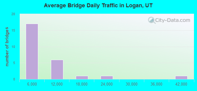
- 185,314Total average daily traffic
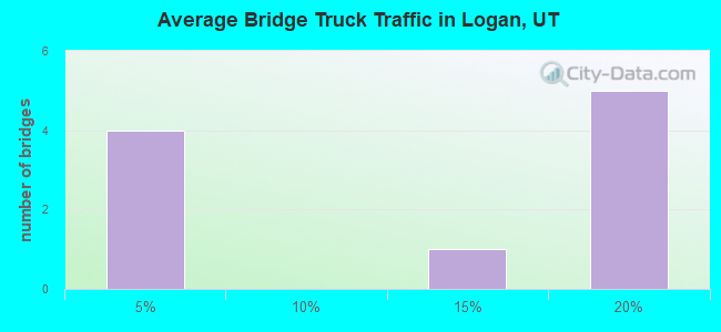
- 15,138Total average daily truck traffic
- 231,213Total future (year 2040) average daily traffic
- National Bridge Inventory (NBI) Registered Bridges for Logan
- No street view available for this location
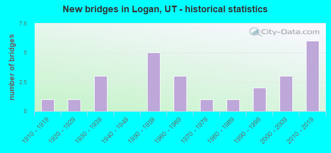
- New bridges - historical statistics
- 11910-1919
- 11920-1929
- 31930-1939
- 51950-1959
- 31960-1969
- 11970-1979
- 11980-1989
- 21990-1999
- 32000-2009
- 62010-2019
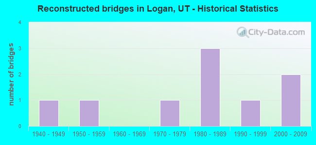
- Reconstructed bridges - Historical Statistics
- 11940-1949
- 11950-1959
- 01960-1969
- 11970-1979
- 31980-1989
- 11990-1999
- 22000-2009
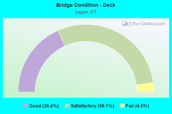
- Bridge Condition - Deck
- 36.4%Good
- 59.1%Satisfactory
- 4.5%Fair
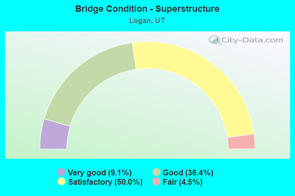
- Bridge Condition - Superstructure
- 9.1%Very good
- 36.4%Good
- 50.0%Satisfactory
- 4.5%Fair
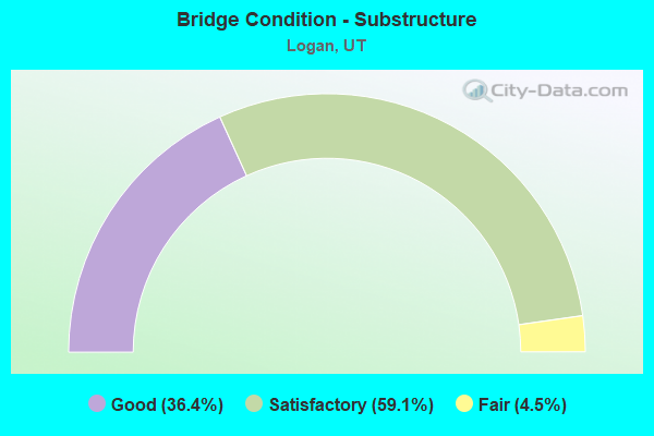
- Bridge Condition - Substructure
- 36.4%Good
- 59.1%Satisfactory
- 4.5%Fair
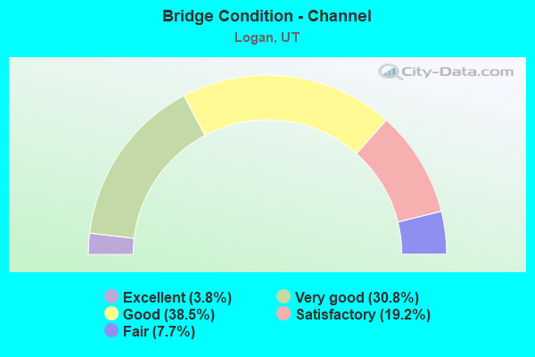
- Bridge Condition - Channel
- 3.8%Excellent
- 30.8%Very good
- 38.5%Good
- 19.2%Satisfactory
- 7.7%Fair
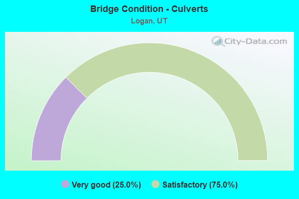
- Bridge Condition - Culverts
- 25.0%Very good
- 75.0%Satisfactory
Find on map >> Show street view
Structure Number: 5002D, Location: 1550 SO. PARK AVE, LOGAN (Lat: 41.706200, Lng: -111.853100), Route carried "on" structure: City street 1200, Year Built: 1953, Status: Posted for load, Structure Length: 1.82m (5.97ft), Average Daily Traffic: 6,318 (year 2020), Average Future Daily Traffic: 7,898 (year 2040), Design Load: H 15, Features Intersected: LOGAN RIVER, Facility Carried by Structure: LOGAN CITY STREET
Minimum Vertical Clearance: 30+ m (98+ ft), Kilometerpoint: 0.349, Lanes on structure: 2, Owner: City or Municipal Highway Agency, Approaching Roadway Width: 7.3m (24.0ft), Material/Design: Concrete, Design/Construction: Frame, Number Of Spans In Main Unit: 1, Length of Maximum Span: 16.8m (55.1ft), Curb or Sidewalk Widths: Left: 0.9m (3.0ft), Right: 0.9m (3.0ft), Curb-To-Curb Width: 7.3m (24.0ft), Out-to-Out Width: 9.2m (30.2ft)
Condition: Deck: Good, Superstructure: Good, Substructure: Good, Channel: Satisfactory, Operating Rating: 26.6 metric tons, Method Used To Determine Operating Rating: Load Factor (LF) rating reported by rating factor (RF) method using MS18 loading, Inventory Rating: 16.8 metric tons, Method Used To Determine Inventory Rating: Load Factor (LF) rating reported by rating factor (RF) method using MS18 loading, Structural Evaluation: Meets minimum limits, Deck Geometry: High priority of replacement, Waterway Adequacy: Meets minimum limits, Approach Roadway Alignment: Equal to present desirable criteria, Bridge Posting: Required (Relationship of Operating Rating to Maximum Legal Load: 10.0 - 19.9% below), Designated Inspection Frequency: Every 24 months, Inspection Date: May 2020, Deck Structure Type: Concrete Cast-file-Place, Wearing Surface/Protective System: Wearing Surface: Bituminous
Find on map >> Show street view
Structure Number: 5009F, Location: 500 S.100 E., LOGAN (Lat: 41.722361, Lng: -111.832675), Route carried "on" structure: ServiceCity street 1223, Year Built: 2007, Status: Open, Structure Length: 2.62m (8.60ft), Average Daily Traffic: 7,858 (year 2020), Average Future Daily Traffic: 9,823 (year 2040), Design Load: HL 93, Features Intersected: LOGAN RIVER, Facility Carried by Structure: 100 EAST STREET
Minimum Vertical Clearance: 30+ m (98+ ft), Kilometerpoint: 1.464, Lanes on structure: 3, Owner: City or Municipal Highway Agency, Approaching Roadway Width: 18.0m (59.1ft), Skew: 3 degrees, Material/Design: Prestressed concrete, Design/Construction: Stringer/Multi-beam, Number Of Spans In Main Unit: 1, Length of Maximum Span: 25.8m (84.6ft), Curb or Sidewalk Widths: Left: 1.8m (5.9ft), Right: 1.8m (5.9ft), Curb-To-Curb Width: 18.0m (59.1ft), Out-to-Out Width: 22.5m (73.8ft)
Condition: Deck: Good, Superstructure: Good, Substructure: Good, Channel: Very good, Operating Rating: 57.3 metric tons, Method Used To Determine Operating Rating: Load and Resistance Factor Rating (LRFR) rating reported by rating factor(RF) method using HL-93 loadings, Inventory Rating: 46.7 metric tons, Method Used To Determine Inventory Rating: Load Factor (LF) rating reported by rating factor (RF) method using MS18 loading, Structural Evaluation: Better than present minimum criteria, Deck Geometry: Superior to present desirable criteria, Waterway Adequacy: Equal to present desirable criteria, Approach Roadway Alignment: Equal to present desirable criteria, Designated Inspection Frequency: Every 24 months, Inspection Date: May 2020, Deck Structure Type: Concrete Cast-file-Place, Wearing Surface/Protective System: Wearing Surface: Monolithic Concrete, Deck Protection: Epoxy Coated Reinforcing
Find on map >> Show street view
Structure Number: 5018D, Location: 250 SO. 300 W., LOGAN (Lat: 41.727208, Lng: -111.842875), Route carried "on" structure: City street , Year Built: 1950, Year Reconstructed: 1994, Status: Posted for load, Structure Length: 0.66m (2.17ft), Average Daily Traffic: 2,772 (year 2020), Truck Traffic: 2%, Average Future Daily Traffic: 3,368 (year 2040), Design Load: HL 93, Features Intersected: BENSON CANAL, Facility Carried by Structure: 300 W. ST. LOGAN
Minimum Vertical Clearance: 30+ m (98+ ft), Kilometerpoint: 0.128, Lanes on structure: 2, Owner: City or Municipal Highway Agency, Approaching Roadway Width: 11.4m (37.4ft), Material/Design: Concrete, Design/Construction: Frame, Number Of Spans In Main Unit: 1, Length of Maximum Span: 6.1m (20.0ft), Curb or Sidewalk Widths: Left: 4.3m (14.1ft), Right: 3.7m (12.1ft), Curb-To-Curb Width: 11.4m (37.4ft), Out-to-Out Width: 19.4m (63.6ft)
Condition: Deck: Good, Superstructure: Good, Substructure: Good, Channel: Good, Operating Rating: 32.4 metric tons, Method Used To Determine Operating Rating: Load and Resistance Factor Rating (LRFR) rating reported by rating factor(RF) method using HL-93 loadings, Inventory Rating: 19.4 metric tons, Method Used To Determine Inventory Rating: Load Factor (LF) rating reported by rating factor (RF) method using MS18 loading, Structural Evaluation: Somewhat better than minimum adequacy, Deck Geometry: Somewhat better than minimum adequacy, Waterway Adequacy: Equal to present minimum criteria, Approach Roadway Alignment: Equal to present desirable criteria, Designated Inspection Frequency: Every 24 months, Inspection Date: May 2020, Deck Structure Type: Concrete Cast-file-Place, Wearing Surface/Protective System: Wearing Surface: Bituminous
Find on map >> Show street view
Structure Number: 5019D, Location: 150 S. 100 W., LOGAN (Lat: 41.728725, Lng: -111.837653), Route carried "on" structure: City street 1220, Year Built: 1950, Year Reconstructed: 1994, Status: Open, Structure Length: 0.79m (2.59ft), Average Daily Traffic: 3,018 (year 2020), Average Future Daily Traffic: 3,773 (year 2040), Design Load: HS 20+Mod, Features Intersected: BENSON CANAL, Facility Carried by Structure: 100 W. ST. LOGAN
Minimum Vertical Clearance: 30+ m (98+ ft), Kilometerpoint: 0.523, Lanes on structure: 2, Owner: City or Municipal Highway Agency, Approaching Roadway Width: 17.2m (56.4ft), Skew: 1 degrees, Material/Design: Concrete, Design/Construction: Frame, Number Of Spans In Main Unit: 2, Length of Maximum Span: 7.0m (23.0ft), Curb or Sidewalk Widths: Left: 2.1m (6.9ft), Right: 2.7m (8.9ft), Curb-To-Curb Width: 17.2m (56.4ft), Out-to-Out Width: 30.8m (101.0ft)
Condition: Deck: Satisfactory, Superstructure: Satisfactory, Substructure: Satisfactory, Channel: Good, Operating Rating: 74.5 metric tons, Method Used To Determine Operating Rating: Load and Resistance Factor Rating (LRFR) rating reported by rating factor(RF) method using HL-93 loadings, Inventory Rating: 32.4 metric tons, Method Used To Determine Inventory Rating: Load Factor (LF) rating reported by rating factor (RF) method using MS18 loading, Structural Evaluation: Equal to present minimum criteria, Deck Geometry: Superior to present desirable criteria, Waterway Adequacy: Meets minimum limits, Approach Roadway Alignment: Equal to present desirable criteria, Designated Inspection Frequency: Every 24 months, Inspection Date: May 2020, Deck Structure Type: Concrete Cast-file-Place, Wearing Surface/Protective System: Wearing Surface: Bituminous
Find on map >> Show street view
Structure Number: 5029C, Location: 900 E. 100 N., LOGAN (Lat: 41.732917, Lng: -111.811942), Route carried "on" structure: City street , Year Built: 1960, Year Reconstructed: 1975, Status: Posted for load, Structure Length: 1.08m (3.54ft), Average Daily Traffic: 2,520 (year 2020), Truck Traffic: 2%, Average Future Daily Traffic: 3,062 (year 2040), Design Load: HL 93, Features Intersected: LOGAN RIVER, Facility Carried by Structure: 100 NO. ST. LOGAN
Minimum Vertical Clearance: 30+ m (98+ ft), Kilometerpoint: 0.010, Lanes on structure: 2, Owner: City or Municipal Highway Agency, Approaching Roadway Width: 9.6m (31.5ft), Skew: 9 degrees, Material/Design: Steel, Design/Construction: Stringer/Multi-beam, Number Of Spans In Main Unit: 1, Length of Maximum Span: 10.3m (33.8ft), Curb or Sidewalk Widths: Left: 1.7m (5.6ft), Right: 1.1m (3.6ft), Curb-To-Curb Width: 9.6m (31.5ft), Out-to-Out Width: 16.0m (52.5ft)
Condition: Deck: Fair, Superstructure: Fair, Substructure: Satisfactory, Channel: Good, Operating Rating: 24.6 metric tons, Method Used To Determine Operating Rating: Load Factor (LF) rating reported by rating factor (RF) method using MS18 loading, Inventory Rating: 19.1 metric tons, Method Used To Determine Inventory Rating: Load Factor (LF) rating reported by rating factor (RF) method using MS18 loading, Structural Evaluation: Somewhat better than minimum adequacy, Deck Geometry: Meets minimum limits, Waterway Adequacy: Equal to present minimum criteria, Approach Roadway Alignment: Better than present minimum criteria, Bridge Posting: Required (Relationship of Operating Rating to Maximum Legal Load: 20.0 - 29.9% below), Designated Inspection Frequency: Every 24 months, Inspection Date: May 2020, Deck Structure Type: Concrete Cast-file-Place, Wearing Surface/Protective System: Wearing Surface: Bituminous
Find on map >> Show street view
Structure Number: 5038F, Location: 800 E. CENTER ST., LOGAN (Lat: 41.731058, Lng: -111.814786), Route carried "on" structure: City street 1192, Year Built: 1983, Year Reconstructed: 1991, Status: Open, Structure Length: 2.03m (6.66ft), Average Daily Traffic: 7,449 (year 2020), Average Future Daily Traffic: 9,311 (year 2040), Features Intersected: LOGAN RIVER, Facility Carried by Structure: LOGAN CITY STREET
Minimum Vertical Clearance: 30+ m (98+ ft), Kilometerpoint: 3.647, Lanes on structure: 2, Owner: City or Municipal Highway Agency, Approaching Roadway Width: 13.0m (42.7ft), Skew: 3 degrees, Material/Design: Prestressed concrete, Design/Construction: Tee Beam, Number Of Spans In Main Unit: 1, Length of Maximum Span: 16.1m (52.8ft), Curb or Sidewalk Widths: Left: 1.8m (5.9ft), Right: 1.8m (5.9ft), Curb-To-Curb Width: 13.0m (42.7ft), Out-to-Out Width: 18.9m (62.0ft)
Condition: Deck: Satisfactory, Superstructure: Satisfactory, Substructure: Fair, Channel: Fair, Operating Rating: 32.4 metric tons, Method Used To Determine Operating Rating: Load and Resistance Factor Rating (LRFR) rating reported by rating factor(RF) method using HL-93 loadings, Inventory Rating: 21.7 metric tons, Method Used To Determine Inventory Rating: Load and Resistance Factor Rating (LRFR) rating reported by rating factor(RF) method using HL-93 loadings, Structural Evaluation: Somewhat better than minimum adequacy, Deck Geometry: Somewhat better than minimum adequacy, Waterway Adequacy: Better than present minimum criteria, Approach Roadway Alignment: Equal to present desirable criteria, Designated Inspection Frequency: Every 24 months, Inspection Date: May 2020, Deck Structure Type: Concrete Cast-file-Place, Wearing Surface/Protective System: Wearing Surface: Bituminous, Deck Protection: Epoxy Coated Reinforcing
Find on map >> Show street view
Structure Number: 5040D, Location: 750 N. 600 E., LOGAN (Lat: 41.744997, Lng: -111.819122), Route carried "on" structure: City street 1238, Year Built: 1995, Status: Open, Structure Length: 0.68m (2.23ft), Average Daily Traffic: 2,819 (year 2020), Average Future Daily Traffic: 3,524 (year 2040), Design Load: HL 93, Features Intersected: LOGAN-NORTHERN CANAL, Facility Carried by Structure: 600 EAST STREET
Minimum Vertical Clearance: 30+ m (98+ ft), Kilometerpoint: 0.688, Lanes on structure: 2, Owner: City or Municipal Highway Agency, Approaching Roadway Width: 15.2m (49.9ft), Skew: 4 degrees, Material/Design: Concrete, Design/Construction: Frame, Number Of Spans In Main Unit: 1, Length of Maximum Span: 4.3m (14.1ft), Curb-To-Curb Width: 15.2m (49.9ft), Out-to-Out Width: 27.4m (89.9ft)
Condition: Deck: Satisfactory, Superstructure: Satisfactory, Substructure: Satisfactory, Channel: Good, Operating Rating: 32.4 metric tons, Method Used To Determine Operating Rating: Load and Resistance Factor Rating (LRFR) rating reported by rating factor(RF) method using HL-93 loadings, Inventory Rating: 21.1 metric tons, Method Used To Determine Inventory Rating: Load and Resistance Factor Rating (LRFR) rating reported by rating factor(RF) method using HL-93 loadings, Structural Evaluation: Somewhat better than minimum adequacy, Deck Geometry: Superior to present desirable criteria, Waterway Adequacy: Equal to present minimum criteria, Approach Roadway Alignment: Equal to present desirable criteria, Designated Inspection Frequency: Every 24 months, Inspection Date: May 2020, Deck Structure Type: Concrete Precast Panels, Wearing Surface/Protective System: Wearing Surface: Bituminous
Find on map >> Show street view
Structure Number: 5043D, Location: 250 E. 500 N., LOGAN (Lat: 41.740856, Lng: -111.828222), Route carried "on" structure: City street 1236, Year Built: 1935, Status: Open, Structure Length: 0.80m (2.62ft), Average Daily Traffic: 5,868 (year 2020), Average Future Daily Traffic: 7,335 (year 2040), Design Load: HL 93, Features Intersected: HYDE PARK CANAL, Facility Carried by Structure: 500 NO. ST. LOGAN
Minimum Vertical Clearance: 30+ m (98+ ft), Kilometerpoint: 0.539, Lanes on structure: 2, Owner: City or Municipal Highway Agency, Approaching Roadway Width: 16.8m (55.1ft), Skew: 1 degrees, Material/Design: Concrete continuous, Design/Construction: Slab, Number Of Spans In Main Unit: 2, Length of Maximum Span: 3.8m (12.5ft), Curb-To-Curb Width: 16.8m (55.1ft), Out-to-Out Width: 18.1m (59.4ft)
Condition: Deck: Satisfactory, Superstructure: Satisfactory, Substructure: Satisfactory, Channel: Very good, Operating Rating: 32.4 metric tons, Method Used To Determine Operating Rating: Load and Resistance Factor Rating (LRFR) rating reported by rating factor(RF) method using HL-93 loadings, Inventory Rating: 17.8 metric tons, Method Used To Determine Inventory Rating: Load Factor (LF) rating reported by rating factor (RF) method using MS18 loading, Structural Evaluation: Meets minimum limits, Deck Geometry: Superior to present desirable criteria, Waterway Adequacy: Meets minimum limits, Approach Roadway Alignment: Equal to present desirable criteria, Designated Inspection Frequency: Every 24 months, Inspection Date: May 2020, Deck Structure Type: Concrete Cast-file-Place, Wearing Surface/Protective System: Wearing Surface: Bituminous
Find on map >> Show street view
Structure Number: 5044D, Location: 270 E. 600 N., LOGAN (Lat: 41.742792, Lng: -111.827869), Route carried "on" structure: City street , Year Built: 1935, Status: Posted for load, Structure Length: 1.01m (3.31ft), Average Daily Traffic: 4,536 (year 2020), Truck Traffic: 2%, Average Future Daily Traffic: 5,511 (year 2040), Design Load: HL 93, Features Intersected: HYDE PARK CANAL, Facility Carried by Structure: 600 NO. ST. LOGAN
Minimum Vertical Clearance: 30+ m (98+ ft), Kilometerpoint: 0.135, Lanes on structure: 2, Owner: City or Municipal Highway Agency, Approaching Roadway Width: 15.3m (50.2ft), Skew: 2 degrees, Material/Design: Concrete continuous, Design/Construction: Slab, Number Of Spans In Main Unit: 2, Length of Maximum Span: 4.6m (15.1ft), Curb or Sidewalk Widths: Left: 2.4m (7.9ft), Right: 2.4m (7.9ft), Curb-To-Curb Width: 15.3m (50.2ft), Out-to-Out Width: 20.1m (65.9ft)
Condition: Deck: Satisfactory, Superstructure: Satisfactory, Substructure: Satisfactory, Channel: Good, Operating Rating: 32.4 metric tons, Method Used To Determine Operating Rating: Load and Resistance Factor Rating (LRFR) rating reported by rating factor(RF) method using HL-93 loadings, Inventory Rating: 18.5 metric tons, Method Used To Determine Inventory Rating: Load Factor (LF) rating reported by rating factor (RF) method using MS18 loading, Structural Evaluation: Somewhat better than minimum adequacy, Deck Geometry: Superior to present desirable criteria, Waterway Adequacy: Somewhat better than minimum adequacy, Approach Roadway Alignment: Equal to present desirable criteria, Designated Inspection Frequency: Every 24 months, Inspection Date: May 2020, Deck Structure Type: Concrete Cast-file-Place, Wearing Surface/Protective System: Wearing Surface: Bituminous
Find on map >> Show street view
Structure Number: 5045D, Location: 900 E. 1400 N., LOGAN (Lat: 41.757244, Lng: -111.811228), Route carried "on" structure: City street 1244, Year Built: 1969, Year Reconstructed: 2000, Status: Open, Structure Length: 1.02m (3.35ft), Average Daily Traffic: 7,914 (year 2020), Average Future Daily Traffic: 9,893 (year 2040), Design Load: HL 93, Features Intersected: LOGAN NORTHERN CANAL, Facility Carried by Structure: 1400 NORTH STREET
Minimum Vertical Clearance: 30+ m (98+ ft), Kilometerpoint: 3.229, Lanes on structure: 2, Owner: City or Municipal Highway Agency, Approaching Roadway Width: 14.6m (47.9ft), Skew: 6 degrees, Material/Design: Concrete, Design/Construction: Slab, Number Of Spans In Main Unit: 1, Length of Maximum Span: 8.5m (27.9ft), Curb or Sidewalk Widths: Left: 0.0m, Right: 3.7m (12.1ft), Curb-To-Curb Width: 14.6m (47.9ft), Out-to-Out Width: 50.9m (167.0ft)
Condition: Deck: Satisfactory, Superstructure: Satisfactory, Substructure: Good, Channel: Good, Operating Rating: 32.4 metric tons, Method Used To Determine Operating Rating: Load and Resistance Factor Rating (LRFR) rating reported by rating factor(RF) method using HL-93 loadings, Inventory Rating: 20.7 metric tons, Method Used To Determine Inventory Rating: Load Factor (LF) rating reported by rating factor (RF) method using MS18 loading, Structural Evaluation: Somewhat better than minimum adequacy, Deck Geometry: Superior to present desirable criteria, Waterway Adequacy: Somewhat better than minimum adequacy, Approach Roadway Alignment: Equal to present desirable criteria, Designated Inspection Frequency: Every 24 months, Inspection Date: May 2020, Deck Structure Type: Concrete Cast-file-Place, Wearing Surface/Protective System: Wearing Surface: Bituminous
Find on map >> Show street view
Structure Number: 5046D, Location: 210 N. 200 E., LOGAN (Lat: 41.736681, Lng: -111.829631), Route carried "on" structure: City street 1232, Year Built: 1920, Status: Posted for load, Structure Length: 1.58m (5.18ft), Average Daily Traffic: 8,853 (year 2020), Average Future Daily Traffic: 11,066 (year 2040), Design Load: HL 93, Features Intersected: HYDE PARK CANAL, Facility Carried by Structure: 200 E. ST. LOGAN
Minimum Vertical Clearance: 30+ m (98+ ft), Kilometerpoint: 0.597, Lanes on structure: 2, Owner: City or Municipal Highway Agency, Approaching Roadway Width: 16.6m (54.5ft), Skew: 7 degrees, Material/Design: Concrete continuous, Design/Construction: Frame, Number Of Spans In Main Unit: 2, Length of Maximum Span: 14.0m (45.9ft), Curb or Sidewalk Widths: Left: 1.2m (3.9ft), Right: 1.2m (3.9ft), Curb-To-Curb Width: 16.6m (54.5ft), Out-to-Out Width: 30.9m (101.4ft)
Condition: Deck: Good, Superstructure: Good, Substructure: Good, Channel: Satisfactory, Operating Rating: 32.4 metric tons, Method Used To Determine Operating Rating: Load and Resistance Factor Rating (LRFR) rating reported by rating factor(RF) method using HL-93 loadings, Inventory Rating: 22.7 metric tons, Method Used To Determine Inventory Rating: Load Factor (LF) rating reported by rating factor (RF) method using MS18 loading, Structural Evaluation: Somewhat better than minimum adequacy, Deck Geometry: Superior to present desirable criteria, Waterway Adequacy: Meets minimum limits, Approach Roadway Alignment: Equal to present desirable criteria, Designated Inspection Frequency: Every 24 months, Inspection Date: May 2020, Deck Structure Type: Concrete Cast-file-Place, Wearing Surface/Protective System: Wearing Surface: Bituminous
Find on map >> Show street view
Structure Number: 5048D, Location: 500 E. 200 N., LOGAN (Lat: 41.734989, Lng: -111.821975), Route carried "on" structure: City street , Year Built: 1965, Year Reconstructed: 1995, Status: Posted for load, Structure Length: 0.75m (2.46ft), Average Daily Traffic: 2,520 (year 2020), Truck Traffic: 1%, Average Future Daily Traffic: 3,062 (year 2040), Design Load: H 15, Features Intersected: HYDE PARK CANAL, Facility Carried by Structure: 200 NORTH STREET
Minimum Vertical Clearance: 30+ m (98+ ft), Kilometerpoint: 0.010, Lanes on structure: 2, Owner: City or Municipal Highway Agency, Approaching Roadway Width: 11.0m (36.1ft), Skew: 3 degrees, Material/Design: Concrete, Design/Construction: Slab, Number Of Spans In Main Unit: 1, Length of Maximum Span: 7.0m (23.0ft), Curb or Sidewalk Widths: Left: 1.1m (3.6ft), Right: 2.1m (6.9ft), Curb-To-Curb Width: 11.0m (36.1ft), Out-to-Out Width: 24.8m (81.4ft)
Condition: Deck: Satisfactory, Superstructure: Satisfactory, Substructure: Satisfactory, Channel: Satisfactory, Operating Rating: 32.4 metric tons, Method Used To Determine Operating Rating: Load and Resistance Factor Rating (LRFR) rating reported by rating factor(RF) method using HL-93 loadings, Inventory Rating: 19.8 metric tons, Method Used To Determine Inventory Rating: Load Factor (LF) rating reported by rating factor (RF) method using MS18 loading, Structural Evaluation: Somewhat better than minimum adequacy, Deck Geometry: Somewhat better than minimum adequacy, Waterway Adequacy: Somewhat better than minimum adequacy, Approach Roadway Alignment: Meets minimum limits, Designated Inspection Frequency: Every 24 months, Inspection Date: May 2020, Deck Structure Type: Concrete Cast-file-Place, Wearing Surface/Protective System: Wearing Surface: Bituminous
Find on map >> Show street view
Structure Number: 5058D, Location: 350 S. 400 E., LOGAN (Lat: 41.725053, Lng: -111.825711), Route carried "on" structure: City street 1197, Year Built: 1958, Status: Open, Structure Length: 1.89m (6.20ft), Average Daily Traffic: 4,585 (year 2020), Average Future Daily Traffic: 5,731 (year 2040), Design Load: H 15, Features Intersected: LOGAN RIVER, Facility Carried by Structure: 400 EAST STREET
Minimum Vertical Clearance: 30+ m (98+ ft), Kilometerpoint: 6.747, Lanes on structure: 2, Owner: City or Municipal Highway Agency, Approaching Roadway Width: 9.8m (32.2ft), Material/Design: Concrete, Design/Construction: Frame, Number Of Spans In Main Unit: 1, Length of Maximum Span: 16.8m (55.1ft), Curb or Sidewalk Widths: Left: 1.5m (4.9ft), Right: 1.5m (4.9ft), Curb-To-Curb Width: 9.8m (32.2ft), Out-to-Out Width: 12.9m (42.3ft)
Condition: Deck: Satisfactory, Superstructure: Satisfactory, Substructure: Good, Channel: Fair, Operating Rating: 35.0 metric tons, Method Used To Determine Operating Rating: Load and Resistance Factor Rating (LRFR) rating reported by rating factor(RF) method using HL-93 loadings, Inventory Rating: 24.3 metric tons, Method Used To Determine Inventory Rating: Load Factor (LF) rating reported by rating factor (RF) method using MS18 loading, Structural Evaluation: Equal to present minimum criteria, Deck Geometry: Meets minimum limits, Waterway Adequacy: Equal to present desirable criteria, Approach Roadway Alignment: Equal to present desirable criteria, Designated Inspection Frequency: Every 24 months, Inspection Date: May 2020, Deck Structure Type: Concrete Cast-file-Place, Wearing Surface/Protective System: Wearing Surface: Bituminous
Find on map >> Show street view
Structure Number: 5060D, Location: 1280 N. 800 E., LOGAN (Lat: 41.754942, Lng: -111.813858), Route carried "on" structure: City street 1267, Year Built: 2010, Status: Open, Structure Length: 0.78m (2.56ft), Average Daily Traffic: 5,636 (year 2020), Average Future Daily Traffic: 7,045 (year 2040), Design Load: HS 20+Mod, Features Intersected: LOGAN-NORTHERN CANAL, Facility Carried by Structure: 800 E (Old SR 237)
Minimum Vertical Clearance: 30+ m (98+ ft), Kilometerpoint: 1.161, Lanes on structure: 5, Owner: City or Municipal Highway Agency, Approaching Roadway Width: 23.5m (77.1ft), Skew: 4 degrees, Material/Design: Concrete, Design/Construction: Frame, Number Of Spans In Main Unit: 1, Length of Maximum Span: 7.0m (23.0ft), Curb or Sidewalk Widths: Left: 0.0m, Right: 2.0m (6.6ft), Curb-To-Curb Width: 23.5m (77.1ft), Out-to-Out Width: 24.7m (81.0ft)
Condition: Deck: Satisfactory, Superstructure: Satisfactory, Substructure: Satisfactory, Channel: Good, Operating Rating: 38.9 metric tons, Method Used To Determine Operating Rating: Load Factor (LF) rating reported by rating factor (RF) method using MS18 loading, Inventory Rating: 28.8 metric tons, Method Used To Determine Inventory Rating: Load Factor (LF) rating reported by rating factor (RF) method using MS18 loading, Structural Evaluation: Equal to present minimum criteria, Deck Geometry: Better than present minimum criteria, Waterway Adequacy: Somewhat better than minimum adequacy, Approach Roadway Alignment: Equal to present desirable criteria, Designated Inspection Frequency: Every 24 months, Inspection Date: May 2020, Deck Structure Type: Concrete Cast-file-Place, Wearing Surface/Protective System: Wearing Surface: Bituminous
Find on map >> Show street view
Structure Number: 5061V, Location: 1450 S. PARK AVE., LOGAN (Lat: 41.707200, Lng: -111.853100), Route carried "on" structure: Alternate County highway 1200, Year Built: 2012, Status: Open, Structure Length: 1.18m (3.87ft), Average Daily Traffic: 6,318 (year 2020), Average Future Daily Traffic: 7,898 (year 2040), Design Load: HS 20+Mod, Features Intersected: FLOOD CONTROL, Facility Carried by Structure: PARK AVENUE
Minimum Vertical Clearance: 30+ m (98+ ft), Kilometerpoint: 0.469, Lanes on structure: 2, Owner: City or Municipal Highway Agency, Approaching Roadway Width: 8.5m (27.9ft), Material/Design: Concrete, Design/Construction: Culvert, Number Of Spans In Main Unit: 5, Length of Maximum Span: 1.5m (4.9ft)
Condition: Channel: Good, Culverts: Very good, Operating Rating: 51.8 metric tons, Method Used To Determine Operating Rating: Load and Resistance Factor Rating (LRFR) rating reported by rating factor(RF) method using HL-93 loadings, Inventory Rating: 26.2 metric tons, Method Used To Determine Inventory Rating: Load and Resistance Factor Rating (LRFR) rating reported by rating factor(RF) method using HL-93 loadings, Structural Evaluation: Equal to present minimum criteria, Waterway Adequacy: Better than present minimum criteria, Approach Roadway Alignment: Equal to present desirable criteria, Designated Inspection Frequency: Every 24 months, Inspection Date: May 2020
Find on map >> Show street view
Structure Number: 5063E, Location: 1700 S. BLACKSMITH FORK R (Lat: 41.702669, Lng: -111.844442), Route carried "on" structure: County highway 1193, Year Built: 2014, Status: Open, Structure Length: 1.22m (4.00ft), Average Daily Traffic: 4,987 (year 2020), Average Future Daily Traffic: 6,234 (year 2040), Design Load: HL 93, Features Intersected: BLACKSMITH FORK RIVER, Facility Carried by Structure: 1700 SOUTH
Minimum Vertical Clearance: 30+ m (98+ ft), Kilometerpoint: 0.610, Lanes on structure: 3, Owner: City or Municipal Highway Agency, Approaching Roadway Width: 11.0m (36.1ft), Skew: 4 degrees, Material/Design: Concrete, Design/Construction: Culvert, Number Of Spans In Main Unit: 1, Length of Maximum Span: 5.2m (17.1ft), Curb or Sidewalk Widths: Left: 1.5m (4.9ft), Right: 1.5m (4.9ft)
Condition: Channel: Very good, Culverts: Satisfactory, Operating Rating: 43.7 metric tons, Method Used To Determine Operating Rating: Load and Resistance Factor Rating (LRFR) rating reported by rating factor(RF) method using HL-93 loadings, Inventory Rating: 30.5 metric tons, Method Used To Determine Inventory Rating: Load and Resistance Factor Rating (LRFR) rating reported by rating factor(RF) method using HL-93 loadings, Structural Evaluation: Equal to present minimum criteria, Waterway Adequacy: Equal to present desirable criteria, Approach Roadway Alignment: Equal to present desirable criteria, Designated Inspection Frequency: Every 24 months, Inspection Date: May 2020
Find on map >> Show street view
Structure Number: 5064F, Location: 1 MILE SOUTH OF LOGAN (Lat: 41.702817, Lng: -111.842733), Route carried "on" structure: County highway 1193, Year Built: 2014, Status: Open, Structure Length: 3.06m (10.04ft), Average Daily Traffic: 4,987 (year 2020), Average Future Daily Traffic: 6,234 (year 2040), Design Load: HL 93, Features Intersected: BLACKSMITH FORK RIVER, Facility Carried by Structure: 1700 S. COUNTY RD.
Minimum Vertical Clearance: 30+ m (98+ ft), Kilometerpoint: 0.753, Lanes on structure: 3, Owner: City or Municipal Highway Agency, Approaching Roadway Width: 13.4m (44.0ft), Skew: 2 degrees, Material/Design: Concrete, Design/Construction: Stringer/Multi-beam, Number Of Spans In Main Unit: 1, Length of Maximum Span: 29.9m (98.1ft), Curb or Sidewalk Widths: Left: 1.7m (5.6ft), Right: 1.7m (5.6ft), Curb-To-Curb Width: 13.4m (44.0ft), Out-to-Out Width: 17.7m (58.1ft)
Condition: Deck: Satisfactory, Superstructure: Very good, Substructure: Satisfactory, Channel: Very good, Operating Rating: 48.0 metric tons, Method Used To Determine Operating Rating: Load and Resistance Factor Rating (LRFR) rating reported by rating factor(RF) method using HL-93 loadings, Inventory Rating: 28.8 metric tons, Method Used To Determine Inventory Rating: Load and Resistance Factor Rating (LRFR) rating reported by rating factor(RF) method using HL-93 loadings, Structural Evaluation: Equal to present minimum criteria, Deck Geometry: Somewhat better than minimum adequacy, Waterway Adequacy: Superior to present desirable criteria, Approach Roadway Alignment: Equal to present desirable criteria, Designated Inspection Frequency: Every 24 months, Inspection Date: May 2020, Wearing Surface/Protective System: Wearing Surface: Bituminous, Membrane: Preformed Fabric, Deck Protection: Epoxy Coated Reinforcing
Find on map >> Show street view
Structure Number: 5065F, Location: CACHE CO. HIGH SCHOOL #3 (Lat: 41.685586, Lng: -111.832742), Route carried "on" structure: County highway , Year Built: 2015, Status: Open, Structure Length: 2.77m (9.09ft), Average Daily Traffic: 500 (year 2020), Average Future Daily Traffic: 625 (year 2040), Design Load: HL 93, Features Intersected: BLACKSMITH FORK RIVER, Facility Carried by Structure: 2600 SOUTH
Minimum Vertical Clearance: 30.18m (99.02ft), Kilometerpoint: 0.090, Lanes on structure: 2, Owner: County Highway Agency, Approaching Roadway Width: 17.4m (57.1ft), Skew: 10 degrees, Material/Design: Prestressed concrete, Design/Construction: Tee Beam, Number Of Spans In Main Unit: 1, Length of Maximum Span: 27.7m (90.9ft), Curb or Sidewalk Widths: Left: 2.3m (7.5ft), Right: 2.3m (7.5ft), Curb-To-Curb Width: 17.4m (57.1ft), Out-to-Out Width: 18.3m (60.0ft)
Condition: Deck: Good, Superstructure: Very good, Substructure: Good, Channel: Very good, Operating Rating: 86.2 metric tons, Method Used To Determine Operating Rating: Load and Resistance Factor Rating (LRFR) rating reported by rating factor(RF) method using HL-93 loadings, Inventory Rating: 48.0 metric tons, Method Used To Determine Inventory Rating: Load and Resistance Factor Rating (LRFR) rating reported by rating factor(RF) method using HL-93 loadings, Structural Evaluation: Better than present minimum criteria, Deck Geometry: Superior to present desirable criteria, Waterway Adequacy: Equal to present desirable criteria, Approach Roadway Alignment: Equal to present desirable criteria, Designated Inspection Frequency: Every 24 months, Inspection Date: May 2020, Deck Structure Type: Other, Wearing Surface/Protective System: Wearing Surface: Monolithic Concrete, Membrane: Preformed Fabric, Deck Protection: Epoxy Coated Reinforcing
Find on map >> Show street view
Structure Number: D 54, Location: 600 SOUTH MAIN IN LOGAN (Lat: 41.720858, Lng: -111.835264), Route carried "on" structure: US 91, Year Built: 1918, Year Reconstructed: 1951, Status: Open, Structure Length: 2.99m (9.81ft), Average Daily Traffic: 39,080 (year 2020), Truck Traffic: 18%, Average Future Daily Traffic: 48,850 (year 2040), Design Load: H 15, Features Intersected: LOGAN RIVER
Minimum Vertical Clearance: 30+ m (98+ ft), Kilometerpoint: 41.636, Lanes on structure: 5, Base Highway Network: Yes, Owner: State Highway Agency, Approaching Roadway Width: 21.9m (71.9ft), Skew: 3 degrees, Material/Design: Concrete, Design/Construction: Arch - Deck, Number Of Spans In Main Unit: 1, Length of Maximum Span: 21.3m (69.9ft), Curb or Sidewalk Widths: Left: 1.6m (5.2ft), Right: 1.6m (5.2ft), Curb-To-Curb Width: 21.9m (71.9ft), Out-to-Out Width: 25.8m (84.6ft)
Condition: Deck: Good, Superstructure: Satisfactory, Substructure: Satisfactory, Channel: Satisfactory, Operating Rating: 97.2 metric tons, Method Used To Determine Operating Rating: Load and Resistance Factor Rating (LRFR) rating reported by rating factor(RF) method using HL-93 loadings, Inventory Rating: 96.9 metric tons, Method Used To Determine Inventory Rating: Load and Resistance Factor Rating (LRFR) rating reported by rating factor(RF) method using HL-93 loadings, Structural Evaluation: Equal to present minimum criteria, Deck Geometry: Somewhat better than minimum adequacy, Waterway Adequacy: Equal to present minimum criteria, Approach Roadway Alignment: Equal to present desirable criteria, Designated Inspection Frequency: Every 24 months, Inspection Date: July 2021, Deck Structure Type: Concrete Cast-file-Place, Wearing Surface/Protective System: Wearing Surface: Bituminous
Find on map >> Show street view
Structure Number: D 597, Location: SOUTH EDGE of LOGAN (Lat: 41.704136, Lng: -111.850619), Route carried "on" structure: US 91, Year Built: 1958, Status: Open, Structure Length: 1.73m (5.68ft), Average Daily Traffic: 19,377 (year 2020), Truck Traffic: 18%, Average Future Daily Traffic: 24,221 (year 2040), Design Load: HS 20+Mod, Features Intersected: BLACKSMITH FORK RIVER
Minimum Vertical Clearance: 30+ m (98+ ft), Kilometerpoint: 39.283, Lanes on structure: 5, Base Highway Network: Yes, Owner: State Highway Agency, Approaching Roadway Width: 22.6m (74.1ft), Skew: 1 degrees, Material/Design: Concrete, Design/Construction: Frame, Number Of Spans In Main Unit: 1, Length of Maximum Span: 15.2m (49.9ft), Curb-To-Curb Width: 22.6m (74.1ft), Out-to-Out Width: 24.4m (80.1ft)
Condition: Deck: Good, Superstructure: Good, Substructure: Good, Channel: Satisfactory, Operating Rating: 37.3 metric tons, Method Used To Determine Operating Rating: Load and Resistance Factor Rating (LRFR) rating reported by rating factor(RF) method using HL-93 loadings, Inventory Rating: 24.6 metric tons, Method Used To Determine Inventory Rating: Load and Resistance Factor Rating (LRFR) rating reported by rating factor(RF) method using HL-93 loadings, Structural Evaluation: Equal to present minimum criteria, Deck Geometry: Equal to present minimum criteria, Waterway Adequacy: Equal to present minimum criteria, Approach Roadway Alignment: Equal to present desirable criteria, Designated Inspection Frequency: Every 24 months, Inspection Date: July 2021, Deck Structure Type: Concrete Cast-file-Place, Wearing Surface/Protective System: Wearing Surface: Bituminous
Find on map >> Show street view
Structure Number: E1233, Location: 1 MILE UP LOGAN CANYON (Lat: 41.743303, Lng: -111.761867), Route carried "on" structure: US 89, Year Built: 1931, Year Reconstructed: 1962, Status: Open, Structure Length: 1.92m (6.30ft), Average Daily Traffic: 4,956 (year 2020), Truck Traffic: 16%, Average Future Daily Traffic: 6,195 (year 2040), Design Load: H 15, Features Intersected: HYDE PARK CANAL
Minimum Vertical Clearance: 30+ m (98+ ft), Kilometerpoint: 744.641, Lanes on structure: 2, Base Highway Network: Yes, Owner: State Highway Agency, Approaching Roadway Width: 10.1m (33.1ft), Skew: 8 degrees, Material/Design: Concrete, Design/Construction: Culvert, Number Of Spans In Main Unit: 1, Length of Maximum Span: 16.6m (54.5ft)
Condition: Channel: Very good, Culverts: Satisfactory, Operating Rating: 32.4 metric tons, Method Used To Determine Operating Rating: Load and Resistance Factor Rating (LRFR) rating reported by rating factor(RF) method using HL-93 loadings, Inventory Rating: 13.0 metric tons, Method Used To Determine Inventory Rating: Load Factor (LF) rating reported by rating factor (RF) method using MS18 loading, Structural Evaluation: Meets minimum limits, Waterway Adequacy: Somewhat better than minimum adequacy, Approach Roadway Alignment: Equal to present desirable criteria, Designated Inspection Frequency: Every 24 months, Inspection Date: March 2021
Find on map >> Show street view
Structure Number: F 4, Location: 1200 So.1000 West (Lat: 41.706008, Lng: -111.860461), Route carried "on" structure: State highway 252, Year Built: 1978, Year Reconstructed: 2011, Status: Open, Structure Length: 3.06m (10.04ft), Average Daily Traffic: 15,548 (year 2020), Truck Traffic: 13%, Average Future Daily Traffic: 19,435 (year 2040), Design Load: HS 20+Mod, Features Intersected: LOGAN RIVER
Minimum Vertical Clearance: 30+ m (98+ ft), Kilometerpoint: 0.963, Lanes on structure: 5, Owner: State Highway Agency, Approaching Roadway Width: 25.6m (84.0ft), Skew: 20 degrees, Material/Design: Prestressed concrete, Design/Construction: Stringer/Multi-beam, Number Of Spans In Main Unit: 1, Length of Maximum Span: 30.0m (98.4ft), Curb or Sidewalk Widths: Left: 2.0m (6.6ft), Right: 2.0m (6.6ft), Curb-To-Curb Width: 25.6m (84.0ft), Out-to-Out Width: 30.5m (100.1ft)
Condition: Deck: Satisfactory, Superstructure: Good, Substructure: Satisfactory, Channel: Good, Operating Rating: 43.7 metric tons, Method Used To Determine Operating Rating: Load and Resistance Factor Rating (LRFR) rating reported by rating factor(RF) method using HL-93 loadings, Inventory Rating: 31.1 metric tons, Method Used To Determine Inventory Rating: Load Factor (LF) rating reported by rating factor (RF) method using MS18 loading, Structural Evaluation: Equal to present minimum criteria, Deck Geometry: Superior to present desirable criteria, Waterway Adequacy: Better than present minimum criteria, Approach Roadway Alignment: Equal to present desirable criteria, Designated Inspection Frequency: Every 24 months, Inspection Date: July 2021, Deck Structure Type: Concrete Precast Panels, Wearing Surface/Protective System: Wearing Surface: Epoxy Overlay
Find on map >> Show street view
Structure Number: F 723, Location: 3.3 miles E. of Logan (Lat: 41.741653, Lng: -111.774647), Route carried "on" structure: US 89, Year Built: 2005, Status: Open, Structure Length: 3.27m (10.73ft), Average Daily Traffic: 4,956 (year 2020), Truck Traffic: 16%, Average Future Daily Traffic: 6,195 (year 2040), Design Load: HL 93, Features Intersected: LOGAN RIVER
Minimum Vertical Clearance: 30+ m (98+ ft), Kilometerpoint: 743.553, Lanes on structure: 2, Base Highway Network: Yes, Owner: State Highway Agency, Approaching Roadway Width: 12.5m (41.0ft), Skew: 3 degrees, Material/Design: Prestressed concrete, Design/Construction: Stringer/Multi-beam, Number Of Spans In Main Unit: 1, Length of Maximum Span: 31.9m (104.7ft), Curb-To-Curb Width: 12.5m (41.0ft), Out-to-Out Width: 13.5m (44.3ft)
Condition: Deck: Satisfactory, Superstructure: Good, Substructure: Satisfactory, Channel: Very good, Operating Rating: 43.7 metric tons, Method Used To Determine Operating Rating: Load and Resistance Factor Rating (LRFR) rating reported by rating factor(RF) method using HL-93 loadings, Inventory Rating: 42.8 metric tons, Method Used To Determine Inventory Rating: Load and Resistance Factor Rating (LRFR) rating reported by rating factor(RF) method using HL-93 loadings, Structural Evaluation: Equal to present minimum criteria, Deck Geometry: Equal to present minimum criteria, Waterway Adequacy: Better than present minimum criteria, Approach Roadway Alignment: Equal to present desirable criteria, Designated Inspection Frequency: Every 24 months, Inspection Date: July 2021, Deck Structure Type: Concrete Cast-file-Place, Wearing Surface/Protective System: Wearing Surface: Epoxy Overlay, Deck Protection: Epoxy Coated Reinforcing
Find on map >> Show street view
Structure Number: F 729, Location: At mouth of Logan Canyon (Lat: 41.742958, Lng: -111.786825), Route carried "on" structure: US 89, Year Built: 2005, Status: Open, Structure Length: 3.29m (10.79ft), Average Daily Traffic: 4,956 (year 2020), Truck Traffic: 16%, Average Future Daily Traffic: 6,195 (year 2040), Design Load: HL 93, Features Intersected: LOGAN RIVER
Minimum Vertical Clearance: 30+ m (98+ ft), Kilometerpoint: 742.492, Lanes on structure: 3, Owner: State Highway Agency, Approaching Roadway Width: 17.1m (56.1ft), Skew: 3 degrees, Material/Design: Prestressed concrete, Design/Construction: Stringer/Multi-beam, Number Of Spans In Main Unit: 1, Length of Maximum Span: 32.3m (106.0ft), Curb-To-Curb Width: 17.1m (56.1ft), Out-to-Out Width: 18.0m (59.1ft)
Condition: Deck: Satisfactory, Superstructure: Good, Substructure: Satisfactory, Channel: Very good, Operating Rating: 48.3 metric tons, Method Used To Determine Operating Rating: Load and Resistance Factor Rating (LRFR) rating reported by rating factor(RF) method using HL-93 loadings, Inventory Rating: 47.0 metric tons, Method Used To Determine Inventory Rating: Load and Resistance Factor Rating (LRFR) rating reported by rating factor(RF) method using HL-93 loadings, Structural Evaluation: Equal to present minimum criteria, Deck Geometry: Superior to present desirable criteria, Waterway Adequacy: Equal to present desirable criteria, Approach Roadway Alignment: Equal to present desirable criteria, Designated Inspection Frequency: Every 24 months, Inspection Date: July 2021, Deck Structure Type: Concrete Cast-file-Place, Wearing Surface/Protective System: Wearing Surface: Epoxy Overlay, Deck Protection: Epoxy Coated Reinforcing
Find on map >> Show street view
Structure Number: F 794, Location: 250 W. 1000 S., LOGAN (Lat: 41.716078, Lng: -111.839950), Route carried "on" structure: City street 1204, Year Built: 1994, Status: Open, Structure Length: 2.35m (7.71ft), Average Daily Traffic: 1,036 (year 2020), Average Future Daily Traffic: 1,295 (year 2040), Design Load: H 20, Features Intersected: LOGAN RIVER, Facility Carried by Structure: 1000 SOUTH ST.
Minimum Vertical Clearance: 30+ m (98+ ft), Kilometerpoint: 1.780, Lanes on structure: 2, Owner: City or Municipal Highway Agency, Approaching Roadway Width: 11.4m (37.4ft), Skew: 2 degrees, Material/Design: Prestressed concrete, Design/Construction: Tee Beam, Number Of Spans In Main Unit: 1, Length of Maximum Span: 23.2m (76.1ft), Curb or Sidewalk Widths: Left: 3.0m (9.8ft), Right: 3.0m (9.8ft), Curb-To-Curb Width: 11.4m (37.4ft), Out-to-Out Width: 18.3m (60.0ft)
Condition: Deck: Good, Superstructure: Satisfactory, Substructure: Satisfactory, Channel: Good, Operating Rating: 32.4 metric tons, Method Used To Determine Operating Rating: Load and Resistance Factor Rating (LRFR) rating reported by rating factor(RF) method using HL-93 loadings, Inventory Rating: 20.1 metric tons, Method Used To Determine Inventory Rating: Load and Resistance Factor Rating (LRFR) rating reported by rating factor(RF) method using HL-93 loadings, Structural Evaluation: Somewhat better than minimum adequacy, Deck Geometry: Equal to present minimum criteria, Waterway Adequacy: Equal to present desirable criteria, Approach Roadway Alignment: Equal to present desirable criteria, Designated Inspection Frequency: Every 24 months, Inspection Date: May 2020, Deck Structure Type: Concrete Precast Panels, Wearing Surface/Protective System: Wearing Surface: Bituminous, Membrane: Preformed Fabric, Deck Protection: Epoxy Coated Reinforcing
Find on map >> Show street view
Structure Number: 5062E, Location: 200 E. CENTER ST., LOGAN (Lat: 41.730514, Lng: -111.829819), Route carried "on" structure: City street 1201, Year Built: 2013, Status: Open, Structure Length: 1.10m (3.61ft), Average Daily Traffic: 5,947 (year 2020), Average Future Daily Traffic: 7,434 (year 2040), Design Load: HL 93, Features Intersected: LOGAN RIVER CANAL, Facility Carried by Structure: 200 EAST
Minimum Vertical Clearance: 30+ m (98+ ft), Kilometerpoint: 0.519, Lanes on structure: 3, Owner: City or Municipal Highway Agency, Approaching Roadway Width: 16.2m (53.1ft), Material/Design: Concrete, Design/Construction: Culvert, Number Of Spans In Main Unit: 1, Length of Maximum Span: 9.8m (32.2ft), Curb or Sidewalk Widths: Left: 4.6m (15.1ft), Right: 4.6m (15.1ft)
Condition: Channel: Excellent, Culverts: Satisfactory, Operating Rating: 97.2 metric tons, Method Used To Determine Operating Rating: Load and Resistance Factor Rating (LRFR) rating reported by rating factor(RF) method using HL-93 loadings, Inventory Rating: 72.3 metric tons, Method Used To Determine Inventory Rating: Load and Resistance Factor Rating (LRFR) rating reported by rating factor(RF) method using HL-93 loadings, Structural Evaluation: Equal to present minimum criteria, Waterway Adequacy: Equal to present minimum criteria, Approach Roadway Alignment: Equal to present desirable criteria, Designated Inspection Frequency: Every 24 months, Inspection Date: May 2020