Bridge Statistics for Lloyd, Florida (FL)
Condition, Traffic, Stress, Structural Evaluation, Project Costs
- National Bridge Inventory (NBI) Statistics
- 21Number of bridges
- 253ft / 76.6mTotal length
- 171,872Total average daily traffic
- 40,171Total average daily truck traffic
- National Bridge Inventory (NBI) Registered Bridges for Lloyd
- No street view available for this location
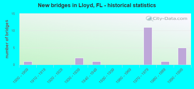
- New bridges - historical statistics
- 11900-1909
- 21930-1939
- 11940-1949
- 111970-1979
- 11980-1989
- 51990-1999

- Reconstructed bridges - Historical Statistics
- 11950-1959
- 01960-1969
- 01970-1979
- 21980-1989
- 11990-1999


- Bridge Condition - Deck
- 25.0%Good
- 66.7%Satisfactory
- 8.3%Fair

- Bridge Condition - Superstructure
- 41.7%Good
- 50.0%Satisfactory
- 8.3%Fair

- Bridge Condition - Substructure
- 41.7%Good
- 50.0%Satisfactory
- 8.3%Fair

- Bridge Condition - Channel
- 6.7%Very good
- 13.3%Good
- 40.0%Satisfactory
- 26.7%Fair
- 13.3%Poor

- Bridge Condition - Culverts
- 16.7%Good
- 66.7%Fair
- 16.7%Poor
Find on map >> Show street view
Structure Number: 540006, Location: 1 Mile N of Lloyd (Lat: 30.487825, Lng: -84.025428), Route carried "on" structure: Interstate 10, Year Built: 1974, Status: Open, Structure Length: 6.16m (20.21ft), Average Daily Traffic: 13,250 (year 2020), Truck Traffic: 29%, Average Future Daily Traffic: 22,989 (year 2042), Design Load: HS 20, Features Intersected: SR59
Minimum Vertical Clearance: 30+ m (98+ ft), Kilometerpoint: 1.543, Lanes on structure: 2, Lanes under structure: 2, Base Highway Network: Yes, Owner: State Highway Agency, Approaching Roadway Width: 11.6m (38.1ft), Material/Design: Prestressed concrete, Design/Construction: Stringer/Multi-beam, Number Of Spans In Main Unit: 2, Length of Maximum Span: 31.1m (102.0ft), Curb-To-Curb Width: 12.2m (40.0ft), Out-to-Out Width: 13.2m (43.3ft)
Condition: Deck: Satisfactory, Superstructure: Satisfactory, Substructure: Good, Inventory Rating: 69.3 metric tons, Method Used To Determine Inventory Rating: Load Factor (LF), Structural Evaluation: Equal to present minimum criteria, Deck Geometry: Better than present minimum criteria, Underclear: Equal to present minimum criteria, Approach Roadway Alignment: Equal to present desirable criteria, Designated Inspection Frequency: Every 24 months, Inspection Date: Febuary 2022, Deck Structure Type: Concrete Cast-file-Place
Find on map >> Show street view
Structure Number: 540019, Location: 2.2MI East of County Line (Lat: 30.489592, Lng: -84.005125), Route carried "on" structure: Interstate 10, Year Built: 1974, Status: Open, Structure Length: 12.65m (41.50ft), Average Daily Traffic: 12,250 (year 2020), Truck Traffic: 27%, Average Future Daily Traffic: 21,254 (year 2042), Design Load: HS 20, Features Intersected: Lloyd Creek
Minimum Vertical Clearance: 30+ m (98+ ft), Kilometerpoint: 3.486, Lanes on structure: 2, Base Highway Network: Yes, Owner: State Highway Agency, Approaching Roadway Width: 9.8m (32.2ft), Material/Design: Prestressed concrete, Design/Construction: Stringer/Multi-beam, Number Of Spans In Main Unit: 6, Length of Maximum Span: 22.9m (75.1ft), Curb-To-Curb Width: 12.2m (40.0ft), Out-to-Out Width: 13.1m (43.0ft)
Condition: Deck: Satisfactory, Superstructure: Satisfactory, Substructure: Satisfactory, Channel: Satisfactory, Operating Rating: 70.2 metric tons, Method Used To Determine Operating Rating: Load Factor (LF), Inventory Rating: 42.2 metric tons, Method Used To Determine Inventory Rating: Load Factor (LF), Structural Evaluation: Equal to present minimum criteria, Deck Geometry: Better than present minimum criteria, Waterway Adequacy: Equal to present desirable criteria, Approach Roadway Alignment: Equal to present desirable criteria, Designated Inspection Frequency: Every 24 months, Underwater Inspection Frequency: Every 24 months, Inspection Date: August 2020, Underwater Inspection Date: August 2020, Deck Structure Type: Concrete Cast-file-Place
Find on map >> Show street view
Structure Number: 540047, Location: 2 Miles East of SR59 (Lat: 30.489022, Lng: -83.983022), Route carried "on" structure: County highway 158, Year Built: 1974, Status: Open, Structure Length: 8.60m (28.22ft), Average Daily Traffic: 2,400 (year 2020), Truck Traffic: 16%, Average Future Daily Traffic: 4,164 (year 2042), Design Load: HS 20, Features Intersected: I10 SR8
Minimum Vertical Clearance: 30.45m (99.90ft), Kilometerpoint: 5.975, Lanes on structure: 2, Lanes under structure: 4, Owner: State Highway Agency, Approaching Roadway Width: 7.3m (24.0ft), Skew: 2 degrees, Material/Design: Prestressed concrete, Design/Construction: Stringer/Multi-beam, Number Of Spans In Main Unit: 4, Length of Maximum Span: 29.3m (96.1ft), Curb-To-Curb Width: 9.8m (32.2ft), Out-to-Out Width: 10.5m (34.4ft)
Condition: Deck: Satisfactory, Superstructure: Good, Substructure: Good, Operating Rating: 59.7 metric tons, Method Used To Determine Operating Rating: Load Factor (LF), Inventory Rating: 35.8 metric tons, Method Used To Determine Inventory Rating: Load Factor (LF), Structural Evaluation: Better than present minimum criteria, Deck Geometry: Meets minimum limits, Underclear: Meets minimum limits, Approach Roadway Alignment: Equal to present desirable criteria, Designated Inspection Frequency: Every 24 months, Inspection Date: Febuary 2022, Deck Structure Type: Concrete Cast-file-Place
Find on map >> Show street view
Structure Number: 540049, Location: 1Mile N of Lloyd (Lat: 30.487586, Lng: -84.025375), Route carried "on" structure: Interstate 10, Year Built: 1974, Status: Open, Structure Length: 6.16m (20.21ft), Average Daily Traffic: 13,250 (year 2020), Truck Traffic: 29%, Average Future Daily Traffic: 22,989 (year 2042), Design Load: HS 20, Features Intersected: SR59
Minimum Vertical Clearance: 30+ m (98+ ft), Kilometerpoint: 1.543, Lanes on structure: 2, Lanes under structure: 2, Base Highway Network: Yes, Owner: State Highway Agency, Approaching Roadway Width: 11.6m (38.1ft), Material/Design: Prestressed concrete, Design/Construction: Stringer/Multi-beam, Number Of Spans In Main Unit: 2, Length of Maximum Span: 31.1m (102.0ft), Curb-To-Curb Width: 12.2m (40.0ft), Out-to-Out Width: 13.2m (43.3ft)
Condition: Deck: Satisfactory, Superstructure: Good, Substructure: Good, Inventory Rating: 69.3 metric tons, Method Used To Determine Inventory Rating: Load Factor (LF), Structural Evaluation: Better than present minimum criteria, Deck Geometry: Better than present minimum criteria, Underclear: Equal to present minimum criteria, Approach Roadway Alignment: Equal to present desirable criteria, Designated Inspection Frequency: Every 24 months, Inspection Date: Febuary 2022, Deck Structure Type: Concrete Cast-file-Place
Find on map >> Show street view
Structure Number: 54005, Location: 1.23 Mi E of SR 59 (Lat: 30.489344, Lng: -84.004933), Route carried "on" structure: Interstate 10, Year Built: 1974, Status: Open, Structure Length: 14.94m (49.02ft), Average Daily Traffic: 12,250 (year 2020), Truck Traffic: 27%, Average Future Daily Traffic: 21,254 (year 2042), Design Load: HS 20, Features Intersected: Lloyd Creek
Minimum Vertical Clearance: 30+ m (98+ ft), Kilometerpoint: 3.486, Lanes on structure: 2, Base Highway Network: Yes, Owner: State Highway Agency, Approaching Roadway Width: 9.8m (32.2ft), Material/Design: Prestressed concrete, Design/Construction: Stringer/Multi-beam, Number Of Spans In Main Unit: 7, Length of Maximum Span: 22.9m (75.1ft), Curb-To-Curb Width: 12.2m (40.0ft), Out-to-Out Width: 13.1m (43.0ft)
Condition: Deck: Satisfactory, Superstructure: Good, Substructure: Good, Channel: Fair, Operating Rating: 70.2 metric tons, Method Used To Determine Operating Rating: Load Factor (LF), Inventory Rating: 42.2 metric tons, Method Used To Determine Inventory Rating: Load Factor (LF), Structural Evaluation: Better than present minimum criteria, Deck Geometry: Better than present minimum criteria, Waterway Adequacy: Equal to present desirable criteria, Approach Roadway Alignment: Equal to present desirable criteria, Designated Inspection Frequency: Every 24 months, Underwater Inspection Frequency: Every 24 months, Inspection Date: August 2020, Underwater Inspection Date: August 2020, Deck Structure Type: Concrete Cast-file-Place
Find on map >> Show street view
Structure Number: 540061, Location: 1.0MI S of SR8 I10 (Lat: 30.474725, Lng: -84.022036), Route carried "on" structure: State highway 59, Year Built: 1977, Status: Open, Structure Length: 6.34m (20.80ft), Average Daily Traffic: 1,381 (year 2020), Truck Traffic: 17%, Average Future Daily Traffic: 2,396 (year 2042), Design Load: HS 20, Features Intersected: Lloyd Creek
Minimum Vertical Clearance: 30+ m (98+ ft), Kilometerpoint: 14.017, Lanes on structure: 2, Owner: State Highway Agency, Approaching Roadway Width: 9.8m (32.2ft), Material/Design: Concrete continuous, Design/Construction: Slab, Number Of Spans In Main Unit: 8, Length of Maximum Span: 7.9m (25.9ft), Curb-To-Curb Width: 13.3m (43.6ft), Out-to-Out Width: 14.1m (46.3ft)
Condition: Deck: Fair, Superstructure: Fair, Substructure: Good, Channel: Satisfactory, Operating Rating: 49.4 metric tons, Method Used To Determine Operating Rating: Load Testing, Inventory Rating: 29.8 metric tons, Method Used To Determine Inventory Rating: Load Testing, Structural Evaluation: Somewhat better than minimum adequacy, Deck Geometry: Better than present minimum criteria, Waterway Adequacy: Equal to present desirable criteria, Approach Roadway Alignment: Equal to present desirable criteria, Designated Inspection Frequency: Every 24 months, Critical Feature Inspection Frequency: Every 24 months, Underwater Inspection Frequency: Every 24 months, Inspection Date: December 2021, Critical Feature Inspection Date: December 2021, Underwater Inspection Date: December 2021, Deck Structure Type: Concrete Cast-file-Place
Find on map >> Show street view
Structure Number: 540068, Location: 3.6 Miles South I-10/SR8 (Lat: 30.438972, Lng: -84.019194), Route carried "on" structure: State highway 59, Year Built: 1984, Year Reconstructed: 1993, Status: Open, Structure Length: 0.78m (2.56ft), Average Daily Traffic: 1,381 (year 2020), Truck Traffic: 17%, Average Future Daily Traffic: 2,396 (year 2042), Design Load: HS 20, Features Intersected: Polar Branch
Minimum Vertical Clearance: 30+ m (98+ ft), Kilometerpoint: 10.044, Lanes on structure: 2, Base Highway Network: Yes, Owner: State Highway Agency, Approaching Roadway Width: 9.8m (32.2ft), Material/Design: Aluminum, Iron, Design/Construction: Culvert, Number Of Spans In Main Unit: 4, Length of Maximum Span: 2.1m (6.9ft)
Condition: Channel: Fair, Culverts: Fair, Structural Evaluation: Somewhat better than minimum adequacy, Waterway Adequacy: Equal to present minimum criteria, Approach Roadway Alignment: Equal to present desirable criteria, Designated Inspection Frequency: Every 24 months, Inspection Date: May 2021
Find on map >> Show street view
Structure Number: 540072, Location: 2.8 Miles East of SR 59 (Lat: 30.528769, Lng: -83.978208), Route carried "on" structure: US 90, Year Built: 1997, Status: Open, Structure Length: 5.97m (19.59ft), Average Daily Traffic: 3,300 (year 2020), Truck Traffic: 8%, Average Future Daily Traffic: 5,726 (year 2042), Design Load: HS 20+Mod, Features Intersected: Lake Miccosukee
Minimum Vertical Clearance: 30+ m (98+ ft), Kilometerpoint: 6.170, Lanes on structure: 2, Base Highway Network: Yes, Owner: State Highway Agency, Approaching Roadway Width: 9.8m (32.2ft), Material/Design: Concrete continuous, Design/Construction: Slab, Number Of Spans In Main Unit: 6, Length of Maximum Span: 10.6m (34.8ft), Curb-To-Curb Width: 13.4m (44.0ft), Out-to-Out Width: 14.3m (46.9ft)
Condition: Deck: Satisfactory, Superstructure: Satisfactory, Substructure: Satisfactory, Channel: Very good, Operating Rating: 62.1 metric tons, Method Used To Determine Operating Rating: Load Factor (LF), Inventory Rating: 37.3 metric tons, Method Used To Determine Inventory Rating: Load Factor (LF), Structural Evaluation: Equal to present minimum criteria, Deck Geometry: Better than present minimum criteria, Waterway Adequacy: Equal to present desirable criteria, Approach Roadway Alignment: Equal to present desirable criteria, Designated Inspection Frequency: Every 24 months, Underwater Inspection Frequency: Every 24 months, Inspection Date: November 2020, Underwater Inspection Date: November 2020, Deck Structure Type: Concrete Cast-file-Place
Find on map >> Show street view
Structure Number: 550008, Location: 7.5 mi East of I10 (Lat: 30.518375, Lng: -84.041883), Route carried "on" structure: US 90, Year Built: 1949, Year Reconstructed: 1990, Status: Open, Structure Length: 2.32m (7.61ft), Average Daily Traffic: 4,000 (year 2020), Truck Traffic: 8%, Average Future Daily Traffic: 6,940 (year 2042), Design Load: HS 20, Features Intersected: Patty Creek
Minimum Vertical Clearance: 30+ m (98+ ft), Kilometerpoint: 25.061, Lanes on structure: 2, Base Highway Network: Yes, Owner: State Highway Agency, Approaching Roadway Width: 10.4m (34.1ft), Material/Design: Concrete, Design/Construction: Slab, Number Of Spans In Main Unit: 5, Length of Maximum Span: 4.6m (15.1ft), Curb-To-Curb Width: 9.1m (29.9ft), Out-to-Out Width: 10.1m (33.1ft)
Condition: Deck: Good, Superstructure: Good, Substructure: Satisfactory, Channel: Satisfactory, Operating Rating: 43.5 metric tons, Method Used To Determine Operating Rating: Load Factor (LF), Inventory Rating: 26.3 metric tons, Method Used To Determine Inventory Rating: Load Factor (LF), Structural Evaluation: Equal to present minimum criteria, Deck Geometry: Meets minimum limits, Waterway Adequacy: Equal to present desirable criteria, Approach Roadway Alignment: Equal to present desirable criteria, Designated Inspection Frequency: Every 24 months, Inspection Date: November 2021, Deck Structure Type: Concrete Cast-file-Place, Wearing Surface/Protective System: Wearing Surface: Bituminous
Find on map >> Show street view
Structure Number: 550012, Location: 0.48 Miles N of US90/SR10 (Lat: 30.525886, Lng: -84.048981), Route carried "on" structure: County highway 59, Year Built: 1901, Year Reconstructed: 1955, Status: Temporarily open, Structure Length: 0.89m (2.92ft), Average Daily Traffic: 1,500 (year 2019), Truck Traffic: 14%, Average Future Daily Traffic: 1,650 (year 2039), Design Load: HL 93, Features Intersected: Unnamed Branch
Minimum Vertical Clearance: 30+ m (98+ ft), Kilometerpoint: 3.970, Lanes on structure: 2, Owner: County Highway Agency, Approaching Roadway Width: 7.0m (23.0ft), Material/Design: Steel, Design/Construction: Culvert, Number Of Spans In Main Unit: 2, Length of Maximum Span: 4.5m (14.8ft)
Condition: Channel: Satisfactory, Culverts: Poor, Structural Evaluation: Meets minimum limits, Waterway Adequacy: Better than present minimum criteria, Approach Roadway Alignment: Equal to present desirable criteria, Designated Inspection Frequency: Every 24 months, Other Special Inspection Frequency: Every 12 months, Inspection Date: Febuary 2022, Other Special Inspection Date: Febuary 2022
Find on map >> Show street view
Structure Number: 550043, Location: 1.0mi West of County Line (Lat: 30.479361, Lng: -84.058500), Route carried "on" structure: Interstate 10, Year Built: 1972, Status: Open, Structure Length: 1.48m (4.86ft), Average Daily Traffic: 26,500 (year 2020), Truck Traffic: 29%, Average Future Daily Traffic: 45,978 (year 2042), Design Load: HS 20, Features Intersected: Black Creek
Minimum Vertical Clearance: 30+ m (98+ ft), Kilometerpoint: 33.983, Lanes on structure: 4, Base Highway Network: Yes, Owner: State Highway Agency, Approaching Roadway Width: 23.2m (76.1ft), Skew: 12 degrees, Material/Design: Concrete, Design/Construction: Culvert, Number Of Spans In Main Unit: 4, Length of Maximum Span: 3.5m (11.5ft)
Condition: Channel: Good, Culverts: Good, Inventory Rating: 64.0 metric tons, Method Used To Determine Inventory Rating: Load Factor (LF), Structural Evaluation: Better than present minimum criteria, Waterway Adequacy: Better than present minimum criteria, Approach Roadway Alignment: Equal to present desirable criteria, Designated Inspection Frequency: Every 24 months, Underwater Inspection Frequency: Every 24 months, Inspection Date: Febuary 2021, Underwater Inspection Date: Febuary 2021
Find on map >> Show street view
Structure Number: 550044, Location: 0.5 mi W. of Countyline (Lat: 30.481694, Lng: -84.049389), Route carried "on" structure: Interstate 8, Year Built: 1972, Status: Open, Structure Length: 1.09m (3.58ft), Average Daily Traffic: 26,500 (year 2020), Truck Traffic: 29%, Average Future Daily Traffic: 45,978 (year 2042), Design Load: HS 20, Features Intersected: Still Creek
Minimum Vertical Clearance: 30+ m (98+ ft), Kilometerpoint: 34.966, Lanes on structure: 4, Base Highway Network: Yes, Owner: State Highway Agency, Approaching Roadway Width: 23.2m (76.1ft), Skew: 11 degrees, Material/Design: Concrete, Design/Construction: Culvert, Number Of Spans In Main Unit: 3, Length of Maximum Span: 3.4m (11.2ft)
Condition: Channel: Fair, Culverts: Fair, Inventory Rating: 76.2 metric tons, Method Used To Determine Inventory Rating: Load Factor (LF), Structural Evaluation: Somewhat better than minimum adequacy, Waterway Adequacy: Equal to present desirable criteria, Approach Roadway Alignment: Equal to present desirable criteria, Designated Inspection Frequency: Every 24 months, Underwater Inspection Frequency: Every 24 months, Inspection Date: November 2021, Underwater Inspection Date: November 2021
Find on map >> Show street view
Structure Number: 550056, Location: 0.96 Mi. S. of US90/SR10 (Lat: 30.501025, Lng: -84.080739), Route carried "on" structure: County highway 364, Year Built: 1935, Status: Open, Structure Length: 0.95m (3.12ft), Average Daily Traffic: 700 (year 2019), Truck Traffic: 7%, Average Future Daily Traffic: 770 (year 2039), Design Load: HS 20, Features Intersected: Black Creek, Facility Carried by Structure: Wadesboro Road
Minimum Vertical Clearance: 30+ m (98+ ft), Kilometerpoint: 5.998, Lanes on structure: 2, Owner: County Highway Agency, Approaching Roadway Width: 6.7m (22.0ft), Material/Design: Concrete, Design/Construction: Culvert, Number Of Spans In Main Unit: 3, Length of Maximum Span: 3.2m (10.5ft)
Condition: Channel: Satisfactory, Culverts: Fair, Operating Rating: 44.5 metric tons, Method Used To Determine Operating Rating: Load Factor (LF), Inventory Rating: 26.3 metric tons, Method Used To Determine Inventory Rating: Load Factor (LF), Structural Evaluation: Somewhat better than minimum adequacy, Waterway Adequacy: Better than present minimum criteria, Approach Roadway Alignment: Equal to present desirable criteria, Designated Inspection Frequency: Every 24 months, Underwater Inspection Frequency: Every 24 months, Inspection Date: May 2020, Underwater Inspection Date: May 2020
Find on map >> Show street view
Structure Number: 554005, Location: 0.8 Mi East of Baum Road (Lat: 30.457431, Lng: -84.079328), Route carried "on" structure: County highway , Year Built: 1938, Year Reconstructed: 1980, Status: Open, Structure Length: 1.61m (5.28ft), Average Daily Traffic: 4,400 (year 2018), Truck Traffic: 6%, Average Future Daily Traffic: 4,840 (year 2038), Design Load: HS 20, Features Intersected: Unnamed Stream, Facility Carried by Structure: Capitola Road
Minimum Vertical Clearance: 30+ m (98+ ft), Kilometerpoint: 6.062, Lanes on structure: 2, Owner: County Highway Agency, Approaching Roadway Width: 6.6m (21.7ft), Material/Design: Concrete, Design/Construction: Culvert, Number Of Spans In Main Unit: 5, Length of Maximum Span: 3.3m (10.8ft)
Condition: Channel: Good, Culverts: Fair, Operating Rating: 30.8 metric tons, Method Used To Determine Operating Rating: Load Factor (LF), Inventory Rating: 19.1 metric tons, Method Used To Determine Inventory Rating: Load Factor (LF), Structural Evaluation: Somewhat better than minimum adequacy, Waterway Adequacy: Better than present minimum criteria, Approach Roadway Alignment: Equal to present desirable criteria, Designated Inspection Frequency: Every 24 months, Inspection Date: March 2020
Find on map >> Show street view
Structure Number: 554033, Location: 0.7 Miles E Baum Rd (Lat: 30.454731, Lng: -84.082058), Route carried "on" structure: County highway , Year Built: 1992, Status: Open, Structure Length: 3.01m (9.88ft), Average Daily Traffic: 5,800 (year 2020), Truck Traffic: 6%, Average Future Daily Traffic: 6,380 (year 2040), Design Load: HS 20, Features Intersected: Unnamed Branch, Facility Carried by Structure: Capitola Road
Minimum Vertical Clearance: 30+ m (98+ ft), Kilometerpoint: 5.652, Lanes on structure: 2, Owner: County Highway Agency, Approaching Roadway Width: 6.7m (22.0ft), Material/Design: Wood or Timber, Design/Construction: Stringer/Multi-beam, Number Of Spans In Main Unit: 9, Length of Maximum Span: 3.6m (11.8ft), Curb or Sidewalk Widths: Left: 0.1m (0.3ft), Right: 0.1m (0.3ft), Curb-To-Curb Width: 10.5m (34.4ft), Out-to-Out Width: 11.0m (36.1ft)
Condition: Deck: Good, Superstructure: Satisfactory, Substructure: Fair, Channel: Poor, Operating Rating: 45.4 metric tons, Method Used To Determine Operating Rating: Allowable Stress (AS), Inventory Rating: 33.6 metric tons, Method Used To Determine Inventory Rating: Allowable Stress (AS), Structural Evaluation: Somewhat better than minimum adequacy, Deck Geometry: High priority of corrective action, Waterway Adequacy: Better than present minimum criteria, Approach Roadway Alignment: Equal to present desirable criteria, Designated Inspection Frequency: Every 24 months, Other Special Inspection Frequency: Every 12 months, Inspection Date: July 2021, Other Special Inspection Date: July 2021, Deck Structure Type: Wood or Timber, Wearing Surface/Protective System: Wearing Surface: Bituminous
Find on map >> Show street view
Structure Number: 554034, Location: 2.34 Miles West of SR 59 (Lat: 30.473922, Lng: -84.057825), Route carried "on" structure: County highway , Year Built: 1992, Status: Open, Structure Length: 1.45m (4.76ft), Average Daily Traffic: 5,800 (year 2019), Truck Traffic: 6%, Average Future Daily Traffic: 6,380 (year 2039), Design Load: HS 20, Features Intersected: Black Creek, Facility Carried by Structure: Capitola Road
Minimum Vertical Clearance: 30+ m (98+ ft), Kilometerpoint: 8.867, Lanes on structure: 2, Owner: County Highway Agency, Approaching Roadway Width: 6.7m (22.0ft), Material/Design: Wood or Timber, Design/Construction: Slab, Number Of Spans In Main Unit: 2, Length of Maximum Span: 7.3m (24.0ft), Curb-To-Curb Width: 10.7m (35.1ft), Out-to-Out Width: 11.3m (37.1ft)
Condition: Deck: Satisfactory, Superstructure: Satisfactory, Substructure: Satisfactory, Channel: Fair, Operating Rating: 47.2 metric tons, Method Used To Determine Operating Rating: Load Factor (LF), Inventory Rating: 33.6 metric tons, Method Used To Determine Inventory Rating: Load Factor (LF), Structural Evaluation: Equal to present minimum criteria, Deck Geometry: High priority of corrective action, Waterway Adequacy: Equal to present minimum criteria, Approach Roadway Alignment: Equal to present desirable criteria, Designated Inspection Frequency: Every 24 months, Underwater Inspection Frequency: Every 24 months, Inspection Date: June 2020, Underwater Inspection Date: June 2020, Deck Structure Type: Wood or Timber, Wearing Surface/Protective System: Wearing Surface: Bituminous
Find on map >> Show street view
Structure Number: 554035, Location: 2.16 Miles West of SR 59 (Lat: 30.474844, Lng: -84.055244), Route carried "on" structure: County highway , Year Built: 1992, Status: Open, Structure Length: 1.48m (4.86ft), Average Daily Traffic: 5,800 (year 2019), Truck Traffic: 6%, Average Future Daily Traffic: 6,380 (year 2039), Design Load: HS 20, Features Intersected: Still Creek, Facility Carried by Structure: Capitola Road
Minimum Vertical Clearance: 30+ m (98+ ft), Kilometerpoint: 9.136, Lanes on structure: 2, Owner: County Highway Agency, Approaching Roadway Width: 6.7m (22.0ft), Material/Design: Wood or Timber, Design/Construction: Slab, Number Of Spans In Main Unit: 2, Length of Maximum Span: 7.5m (24.6ft), Curb-To-Curb Width: 10.7m (35.1ft), Out-to-Out Width: 11.3m (37.1ft)
Condition: Deck: Satisfactory, Superstructure: Satisfactory, Substructure: Satisfactory, Channel: Satisfactory, Operating Rating: 47.2 metric tons, Method Used To Determine Operating Rating: Load Factor (LF), Inventory Rating: 33.6 metric tons, Method Used To Determine Inventory Rating: Load Factor (LF), Structural Evaluation: Equal to present minimum criteria, Deck Geometry: High priority of corrective action, Waterway Adequacy: Better than present minimum criteria, Approach Roadway Alignment: Equal to present desirable criteria, Designated Inspection Frequency: Every 24 months, Underwater Inspection Frequency: Every 24 months, Inspection Date: June 2020, Underwater Inspection Date: June 2020, Deck Structure Type: Wood or Timber, Wearing Surface/Protective System: Wearing Surface: Bituminous
Find on map >> Show street view
Structure Number: 554036, Location: 0.79 Mi E of Baum Rd (Lat: 30.506444, Lng: -84.067667), Route carried "on" structure: County highway , Year Built: 1992, Status: Posted for load, Structure Length: 0.73m (2.40ft), Average Daily Traffic: 110 (year 2020), Truck Traffic: 1%, Average Future Daily Traffic: 120 (year 2040), Features Intersected: Unnamed Branch, Facility Carried by Structure: CR1541-WadesboroRd
Minimum Vertical Clearance: 30+ m (98+ ft), Kilometerpoint: 1.268, Lanes on structure: 2, Owner: County Highway Agency, Approaching Roadway Width: 6.1m (20.0ft), Material/Design: Wood or Timber, Design/Construction: Slab, Number Of Spans In Main Unit: 1, Length of Maximum Span: 7.3m (24.0ft), Curb-To-Curb Width: 10.8m (35.4ft), Out-to-Out Width: 11.4m (37.4ft)
Condition: Deck: Good, Superstructure: Good, Substructure: Satisfactory, Channel: Poor, Operating Rating: 40.8 metric tons, Method Used To Determine Operating Rating: Allowable Stress (AS), Inventory Rating: 29.9 metric tons, Method Used To Determine Inventory Rating: Allowable Stress (AS), Structural Evaluation: Equal to present minimum criteria, Deck Geometry: High priority of corrective action, Waterway Adequacy: Better than present minimum criteria, Approach Roadway Alignment: Equal to present desirable criteria, Bridge Posting: Required (Relationship of Operating Rating to Maximum Legal Load: 0.1 - 9.9% below), Designated Inspection Frequency: Every 24 months, Underwater Inspection Frequency: Every 12 months, Other Special Inspection Frequency: Every 12 months, Inspection Date: July 2021, Underwater Inspection Date: July 2021, Other Special Inspection Date: July 2021, Deck Structure Type: Wood or Timber, Wearing Surface/Protective System: Wearing Surface: Bituminous
Find on map >> Show street view
Structure Number: 540006, Location: 1 Mile N of Lloyd (Lat: 30.487825, Lng: -84.025428), Route carried "under" structure: State highway 59, Year Built: 1974, Structure Length: 0. m, Average Daily Traffic: 3,400 (year 2020), Truck Traffic: 13%, Features Intersected: SR59, Facility Carried by Structure: I10 SR8
Minimum Vertical Clearance: 4.72m (15.49ft), Kilometerpoint: 15.548, Lanes on structure: 2, Lanes under structure: 2, Material/Design: Prestressed concrete, Design/Construction: Stringer/Multi-beam, Length of Maximum Span: 31.1m (102.0ft)
Find on map >> Show street view
Structure Number: 540047, Location: 2 Miles East of SR59 (Lat: 30.489022, Lng: -83.983022), Route carried "under" structure: Interstate 10, Year Built: 1974, Structure Length: 0. m, Average Daily Traffic: 24,500 (year 2020), Truck Traffic: 27%, Features Intersected: I10 SR8, Facility Carried by Structure: CR158
Minimum Vertical Clearance: 4.91m (16.11ft), Kilometerpoint: 5.658, Lanes on structure: 2, Lanes under structure: 4, Material/Design: Prestressed concrete, Design/Construction: Stringer/Multi-beam, Length of Maximum Span: 29.3m (96.1ft)
Find on map >> Show street view
Structure Number: 540049, Location: 1Mile N of Lloyd (Lat: 30.487586, Lng: -84.025375), Route carried "under" structure: State highway 59, Year Built: 1974, Structure Length: 0. m, Average Daily Traffic: 3,400 (year 2020), Truck Traffic: 13%, Features Intersected: SR59, Facility Carried by Structure: I10 SR8
Minimum Vertical Clearance: 4.67m (15.32ft), Kilometerpoint: 15.521, Lanes on structure: 2, Lanes under structure: 2, Material/Design: Prestressed concrete, Design/Construction: Stringer/Multi-beam, Length of Maximum Span: 31.1m (102.0ft)