Bridge Statistics for Livonia, Louisiana (LA)
Condition, Traffic, Stress, Structural Evaluation, Project Costs
- National Bridge Inventory (NBI) Statistics
- 11Number of bridges
- 390ft / 119mTotal length
- $168,000Total costs
- 49,517Total average daily traffic
- 7,523Total average daily truck traffic
- 31,786Total future (year 2036) average daily traffic
- National Bridge Inventory (NBI) Registered Bridges for Livonia
- No street view available for this location
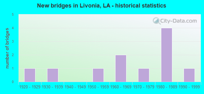
- New bridges - historical statistics
- 11920-1929
- 11930-1939
- 11950-1959
- 21960-1969
- 11970-1979
- 41980-1989
- 11990-1999


- Bridge Condition - Deck
- 42.9%Good
- 42.9%Satisfactory
- 14.3%Serious

- Bridge Condition - Superstructure
- 14.3%Good
- 71.4%Satisfactory
- 14.3%Poor

- Bridge Condition - Substructure
- 14.3%Very good
- 28.6%Good
- 14.3%Satisfactory
- 14.3%Fair
- 28.6%Poor

- Bridge Condition - Channel
- 55.6%Good
- 44.4%Satisfactory

- Bridge Condition - Culverts
- 25.0%Very good
- 25.0%Good
- 50.0%Satisfactory
Find on map >> Show street view
Structure Number: 613900080205401, Location: US0190 (Lat: 30.553481, Lng: -91.502750), Route carried "on" structure: US 190, Year Built: 1951, Status: Open, Structure Length: 0.64m (2.10ft), Average Daily Traffic: 15,100 (year 2016), Truck Traffic: 17%, Average Future Daily Traffic: 8,880 (year 2036), Design Load: H 15, Features Intersected: BAYOU TOMMY
Minimum Vertical Clearance: 30+ m (98+ ft), Kilometerpoint: 8.769, Lanes on structure: 4, Base Highway Network: Yes (Inventory Route: 8-02-1, Subroute: 10), Owner: State Highway Agency, Approaching Roadway Width: 20.7m (67.9ft), Skew: 30 degrees, Material/Design: Concrete, Design/Construction: Culvert, Number Of Spans In Main Unit: 4, Length of Maximum Span: 1.5m (4.9ft), Curb-To-Curb Width: 20.7m (67.9ft), Out-to-Out Width: 30.5m (100.1ft)
Condition: Channel: Good, Culverts: Good, Operating Rating: 42.1 metric tons, Method Used To Determine Operating Rating: Load and Resistance Factor Rating (LRFR) rating reported by rating factor(RF) method using HL-93 loadings, Inventory Rating: 32.4 metric tons, Method Used To Determine Inventory Rating: Load and Resistance Factor Rating (LRFR) rating reported by rating factor(RF) method using HL-93 loadings, Structural Evaluation: Better than present minimum criteria, Deck Geometry: Superior to present desirable criteria, Waterway Adequacy: Equal to present desirable criteria, Approach Roadway Alignment: Equal to present desirable criteria, Designated Inspection Frequency: Every 24 months, Inspection Date: July 2020, Deck Structure Type: Concrete Cast-file-Place
Find on map >> Show street view
Structure Number: 613900080301181, Location: 0.75 MI W JCT LA 77 (Lat: 30.555339, Lng: -91.576531), Route carried "on" structure: US 190, Year Built: 1984, Status: Open, Structure Length: 46.30m (151.90ft), Average Daily Traffic: 5,950 (year 2016), Truck Traffic: 17%, Average Future Daily Traffic: 4,212 (year 2036), Design Load: HS 20, Features Intersected: M.P. RR @ LIVONIA
Minimum Vertical Clearance: 30+ m (98+ ft), Kilometerpoint: 1.802, Lanes on structure: 2, Lanes under structure: 1, Base Highway Network: Yes (Inventory Route: 8-03-1, Subroute: 10), Owner: State Highway Agency, Approaching Roadway Width: 19.8m (65.0ft), Skew: 10 degrees, Material/Design: Prestressed concrete, Design/Construction: Stringer/Multi-beam, Number Of Spans In Main Unit: 22, Length of Maximum Span: 26.8m (87.9ft), Curb-To-Curb Width: 12.2m (40.0ft), Out-to-Out Width: 13.0m (42.7ft)
Condition: Deck: Good, Superstructure: Satisfactory, Substructure: Good, Operating Rating: 57.1 metric tons, Method Used To Determine Operating Rating: Load Factor (LF), Inventory Rating: 32.7 metric tons, Method Used To Determine Inventory Rating: Load Factor (LF), Structural Evaluation: Equal to present minimum criteria, Deck Geometry: Better than present minimum criteria, Underclear: Better than present minimum criteria, Approach Roadway Alignment: Equal to present desirable criteria, Designated Inspection Frequency: Every 24 months, Inspection Date: January 2022, Deck Structure Type: Concrete Cast-file-Place, Wearing Surface/Protective System: Wearing Surface: Monolithic Concrete
Find on map >> Show street view
Structure Number: 613900080301182, Location: 0.75 MI W JCT LA 77 (Lat: 30.555131, Lng: -91.576550), Route carried "on" structure: US 190, Year Built: 1984, Status: Open, Structure Length: 46.30m (151.90ft), Average Daily Traffic: 5,950 (year 2016), Truck Traffic: 17%, Average Future Daily Traffic: 4,212 (year 2036), Design Load: HS 20, Features Intersected: M.P. RR @ LIVONIA
Minimum Vertical Clearance: 30+ m (98+ ft), Kilometerpoint: 15.736, Lanes on structure: 2, Base Highway Network: Yes (Inventory Route: 8-03-2, Subroute: 10), Owner: State Highway Agency, Approaching Roadway Width: 19.8m (65.0ft), Skew: 10 degrees, Material/Design: Prestressed concrete continuous, Design/Construction: Stringer/Multi-beam, Number Of Spans In Main Unit: 22, Length of Maximum Span: 26.8m (87.9ft), Curb-To-Curb Width: 12.2m (40.0ft), Out-to-Out Width: 13.0m (42.7ft)
Condition: Deck: Good, Superstructure: Satisfactory, Substructure: Good, Operating Rating: 57.1 metric tons, Method Used To Determine Operating Rating: Load Factor (LF), Inventory Rating: 32.7 metric tons, Method Used To Determine Inventory Rating: Load Factor (LF), Structural Evaluation: Equal to present minimum criteria, Deck Geometry: Better than present minimum criteria, Underclear: Better than present minimum criteria, Approach Roadway Alignment: Equal to present desirable criteria, Designated Inspection Frequency: Every 24 months, Inspection Date: January 2022, Deck Structure Type: Concrete Cast-file-Place, Wearing Surface/Protective System: Wearing Surface: Monolithic Concrete
Find on map >> Show street view
Structure Number: 613900080301951, Location: 1.82 M W of LA 77@US 190 (Lat: 30.555550, Lng: -91.590639), Route carried "on" structure: US 190, Year Built: 1933, Status: Open, Structure Length: 0.70m (2.30ft), Average Daily Traffic: 11,900 (year 2016), Truck Traffic: 17%, Average Future Daily Traffic: 7,020 (year 2036), Design Load: H 15, Features Intersected: STREAM
Minimum Vertical Clearance: 30+ m (98+ ft), Kilometerpoint: 3.156, Lanes on structure: 4, Base Highway Network: Yes (Inventory Route: 8-03-1, Subroute: 10), Owner: State Highway Agency, Approaching Roadway Width: 14.6m (47.9ft), Skew: 30 degrees, Material/Design: Concrete, Design/Construction: Culvert, Number Of Spans In Main Unit: 5, Length of Maximum Span: 1.2m (3.9ft), Curb-To-Curb Width: 21.0m (68.9ft), Out-to-Out Width: 24.4m (80.1ft)
Condition: Channel: Good, Culverts: Satisfactory, Operating Rating: 42.1 metric tons, Method Used To Determine Operating Rating: Load and Resistance Factor Rating (LRFR) rating reported by rating factor(RF) method using HL-93 loadings, Inventory Rating: 32.4 metric tons, Method Used To Determine Inventory Rating: Load and Resistance Factor Rating (LRFR) rating reported by rating factor(RF) method using HL-93 loadings, Structural Evaluation: Equal to present minimum criteria, Deck Geometry: Superior to present desirable criteria, Waterway Adequacy: Equal to present desirable criteria, Approach Roadway Alignment: Equal to present desirable criteria, Designated Inspection Frequency: Every 24 months, Inspection Date: September 2020, Deck Structure Type: Concrete Cast-file-Place
Find on map >> Show street view
Structure Number: 613902190500041, Location: 0.05 M N of LA 19 (Lat: 30.555219, Lng: -91.558769), Route carried "on" structure: State highway 77, Year Built: 1923, Status: Open, Structure Length: 0.88m (2.89ft), Average Daily Traffic: 2,100 (year 2016), Truck Traffic: 10%, Average Future Daily Traffic: 1,260 (year 2036), Design Load: H 15, Features Intersected: STREAM
Minimum Vertical Clearance: 30+ m (98+ ft), Kilometerpoint: 0.061, Lanes on structure: 2, Owner: State Highway Agency, Approaching Roadway Width: 11.3m (37.1ft), Material/Design: Concrete, Design/Construction: Culvert, Number Of Spans In Main Unit: 5, Length of Maximum Span: 1.5m (4.9ft), Curb-To-Curb Width: 11.3m (37.1ft), Out-to-Out Width: 11.6m (38.1ft)
Condition: Channel: Satisfactory, Culverts: Satisfactory, Operating Rating: 42.1 metric tons, Method Used To Determine Operating Rating: Load and Resistance Factor Rating (LRFR) rating reported by rating factor(RF) method using HL-93 loadings, Inventory Rating: 32.4 metric tons, Method Used To Determine Inventory Rating: Load and Resistance Factor Rating (LRFR) rating reported by rating factor(RF) method using HL-93 loadings, Structural Evaluation: Equal to present minimum criteria, Deck Geometry: Somewhat better than minimum adequacy, Waterway Adequacy: Equal to present minimum criteria, Approach Roadway Alignment: Equal to present desirable criteria, Designated Inspection Frequency: Every 24 months, Inspection Date: September 2020, Deck Structure Type: Concrete Cast-file-Place
Find on map >> Show street view
Structure Number: 613902290503021, Location: LA0078 (Lat: 30.585161, Lng: -91.525389), Route carried "on" structure: State highway 78, Year Built: 1980, Status: Open, Structure Length: 7.32m (24.02ft), Average Daily Traffic: 3,900 (year 2016), Truck Traffic: 10%, Average Future Daily Traffic: 2,340 (year 2036), Design Load: HS 20, Features Intersected: B.GROSSE TETE
Minimum Vertical Clearance: 30+ m (98+ ft), Kilometerpoint: 4.823, Lanes on structure: 2, Owner: State Highway Agency, Approaching Roadway Width: 12.2m (40.0ft), Skew: 9 degrees, Material/Design: Concrete, Design/Construction: Slab, Number Of Spans In Main Unit: 12, Length of Maximum Span: 6.1m (20.0ft), Curb-To-Curb Width: 12.2m (40.0ft), Out-to-Out Width: 13.0m (42.7ft)
Condition: Deck: Satisfactory, Superstructure: Satisfactory, Substructure: Satisfactory, Channel: Satisfactory, Operating Rating: 38.2 metric tons, Method Used To Determine Operating Rating: Load and Resistance Factor Rating (LRFR) rating reported by rating factor(RF) method using HL-93 loadings, Inventory Rating: 29.5 metric tons, Method Used To Determine Inventory Rating: Load and Resistance Factor Rating (LRFR) rating reported by rating factor(RF) method using HL-93 loadings, Structural Evaluation: Equal to present minimum criteria, Deck Geometry: Equal to present minimum criteria, Waterway Adequacy: Equal to present desirable criteria, Approach Roadway Alignment: Equal to present minimum criteria, Designated Inspection Frequency: Every 24 months, Inspection Date: Febuary 2021, Deck Structure Type: Concrete Cast-file-Place, Wearing Surface/Protective System: Wearing Surface: Monolithic Concrete
Find on map >> Show street view
Structure Number: 613908390601691, Location: 0.8 M W of LA 978 (Lat: 30.573481, Lng: -91.501750), Route carried "on" structure: State highway 979, Year Built: 1980, Status: Open, Structure Length: 3.47m (11.38ft), Average Daily Traffic: 680 (year 2016), Truck Traffic: 10%, Average Future Daily Traffic: 408 (year 2036), Design Load: HS 20, Features Intersected: FALSE RIVER CANAL
Minimum Vertical Clearance: 30+ m (98+ ft), Kilometerpoint: 2.725, Lanes on structure: 2, Owner: State Highway Agency, Approaching Roadway Width: 10.7m (35.1ft), Material/Design: Concrete, Design/Construction: Slab, Number Of Spans In Main Unit: 6, Length of Maximum Span: 5.8m (19.0ft), Curb-To-Curb Width: 9.8m (32.2ft), Out-to-Out Width: 10.7m (35.1ft)
Condition: Deck: Satisfactory, Superstructure: Satisfactory, Substructure: Poor, Channel: Satisfactory, Operating Rating: 31.8 metric tons, Method Used To Determine Operating Rating: Load and Resistance Factor Rating (LRFR) rating reported by rating factor(RF) method using HL-93 loadings, Inventory Rating: 25.3 metric tons, Method Used To Determine Inventory Rating: Load and Resistance Factor Rating (LRFR) rating reported by rating factor(RF) method using HL-93 loadings, Structural Evaluation: Meets minimum limits, Deck Geometry: Equal to present minimum criteria, Waterway Adequacy: Equal to present desirable criteria, Approach Roadway Alignment: Equal to present desirable criteria, Designated Inspection Frequency: Every 24 months, Other Special Inspection Frequency: Every 12 months, Inspection Date: November 2020, Other Special Inspection Date: November 2019, Deck Structure Type: Concrete Cast-file-Place, Wearing Surface/Protective System: Wearing Surface: Monolithic Concrete
Find on map >> Show street view
Structure Number: 613908390801971, Location: 1.97 M W of LA 77 (Lat: 30.547100, Lng: -91.590200), Route carried "on" structure: State highway 81, Year Built: 1969, Status: Posted for load, Structure Length: 1.19m (3.90ft), Average Daily Traffic: 510 (year 2016), Truck Traffic: 14%, Average Future Daily Traffic: 300 (year 2036), Design Load: H 15, Features Intersected: W-11 LATERAL #2
Minimum Vertical Clearance: 30+ m (98+ ft), Kilometerpoint: 3.154, Lanes on structure: 2, Owner: State Highway Agency, Approaching Roadway Width: 10.1m (33.1ft), Material/Design: Concrete, Design/Construction: Slab, Number Of Spans In Main Unit: 2, Length of Maximum Span: 5.8m (19.0ft), Curb-To-Curb Width: 7.3m (24.0ft), Out-to-Out Width: 8.7m (28.5ft)
Condition: Deck: Satisfactory, Superstructure: Satisfactory, Substructure: Fair, Channel: Good, Operating Rating: 23.0 metric tons, Method Used To Determine Operating Rating: Load and Resistance Factor Rating (LRFR) rating reported by rating factor(RF) method using HL-93 loadings, Inventory Rating: 17.8 metric tons, Method Used To Determine Inventory Rating: Load and Resistance Factor Rating (LRFR) rating reported by rating factor(RF) method using HL-93 loadings, Structural Evaluation: Meets minimum limits, Deck Geometry: Meets minimum limits, Waterway Adequacy: Equal to present desirable criteria, Approach Roadway Alignment: Equal to present desirable criteria, Bridge Posting: Required (Relationship of Operating Rating to Maximum Legal Load: 0.1 - 9.9% below), Designated Inspection Frequency: Every 24 months, Inspection Date: January 2022, Deck Structure Type: Concrete Cast-file-Place, Wearing Surface/Protective System: Wearing Surface: Bituminous
Find on map >> Show street view
Structure Number: 613908391201091, Location: LA0978 (Lat: 30.568650, Lng: -91.489800), Route carried "on" structure: State highway 978, Year Built: 1962, Status: Open, Structure Length: 3.05m (10.01ft), Average Daily Traffic: 1,230 (year 2016), Truck Traffic: 14%, Average Future Daily Traffic: 738 (year 2036), Design Load: HS 20, Features Intersected: BAYOU GROSSE TETE
Minimum Vertical Clearance: 30+ m (98+ ft), Kilometerpoint: 1.740, Lanes on structure: 2, Owner: State Highway Agency, Approaching Roadway Width: 9.1m (29.9ft), Material/Design: Concrete, Design/Construction: Slab, Number Of Spans In Main Unit: 5, Length of Maximum Span: 6.1m (20.0ft), Curb-To-Curb Width: 7.4m (24.3ft), Out-to-Out Width: 9.0m (29.5ft)
Condition: Deck: Good, Superstructure: Good, Substructure: Very good, Channel: Good, Operating Rating: 39.0 metric tons, Method Used To Determine Operating Rating: Load Factor (LF), Inventory Rating: 23.6 metric tons, Method Used To Determine Inventory Rating: Load Factor (LF), Structural Evaluation: Equal to present minimum criteria, Deck Geometry: Meets minimum limits, Waterway Adequacy: Equal to present desirable criteria, Approach Roadway Alignment: Equal to present desirable criteria, Designated Inspection Frequency: Every 24 months, Inspection Date: Febuary 2020, Deck Structure Type: Concrete Cast-file-Place, Wearing Surface/Protective System: Wearing Surface: Monolithic Concrete
Find on map >> Show street view
Structure Number: 613930335913331, Location: LIVONIA (Lat: 30.559431, Lng: -91.556931), Route carried "on" structure: County highway , Year Built: 1979, Status: Posted for load, Structure Length: 7.56m (24.80ft), Average Daily Traffic: 1,540 (year 2019), Average Future Daily Traffic: 1,694 (year 2039), Design Load: HS 20, Features Intersected: BAYOU GROSSE TETE, Facility Carried by Structure: Bridge Rd
Minimum Vertical Clearance: 30+ m (98+ ft), Kilometerpoint: 0.000, Lanes on structure: 2, Owner: County Highway Agency, Approaching Roadway Width: 9.1m (29.9ft), Material/Design: Concrete, Design/Construction: Slab, Number Of Spans In Main Unit: 13, Length of Maximum Span: 5.8m (19.0ft), Curb or Sidewalk Widths: Left: 0.0m, Right: 1.5m (4.9ft), Curb-To-Curb Width: 7.3m (24.0ft), Out-to-Out Width: 9.4m (30.8ft)
Condition: Deck: Serious, Superstructure: Poor, Substructure: Poor, Channel: Satisfactory, Operating Rating: 19.4 metric tons, Method Used To Determine Operating Rating: Load and Resistance Factor Rating (LRFR) rating reported by rating factor(RF) method using HL-93 loadings, Inventory Rating: 14.9 metric tons, Method Used To Determine Inventory Rating: Load and Resistance Factor Rating (LRFR) rating reported by rating factor(RF) method using HL-93 loadings, Structural Evaluation: Meets minimum limits, Deck Geometry: Meets minimum limits, Waterway Adequacy: Better than present minimum criteria, Approach Roadway Alignment: Better than present minimum criteria, Bridge Posting: Required (Relationship of Operating Rating to Maximum Legal Load: 30.0 - 39.9% below), Designated Inspection Frequency: Every 24 months, Underwater Inspection Frequency: Every 60 months, Other Special Inspection Frequency: Every 12 months, Inspection Date: August 2020, Underwater Inspection Date: April 2019, Other Special Inspection Date: August 2021, Deck Structure Type: Concrete Precast Panels
Find on map >> Show street view
Structure Number: 613930343913021, Location: .4 MI NE OF LIVONIA (Lat: 30.571881, Lng: -91.503931), Route carried "on" structure: County highway , Year Built: 1999, Status: Open, Structure Length: 1.22m (4.00ft), Average Daily Traffic: 657 (year 2019), Average Future Daily Traffic: 722 (year 2039), Design Load: HS 20, Features Intersected: BAYOU TOMMY, Facility Carried by Structure: Gremillion Rd
Minimum Vertical Clearance: 30+ m (98+ ft), Kilometerpoint: 0.000, Lanes on structure: 2, Base Highway Network: Yes, Owner: County Highway Agency, Approaching Roadway Width: 5.5m (18.0ft), Material/Design: Concrete, Design/Construction: Culvert, Number Of Spans In Main Unit: 3, Length of Maximum Span: 3.7m (12.1ft), Curb-To-Curb Width: 5.5m (18.0ft), Out-to-Out Width: 13.7m (44.9ft)
Condition: Channel: Good, Culverts: Very good, Operating Rating: 42.1 metric tons, Method Used To Determine Operating Rating: Load and Resistance Factor Rating (LRFR) rating reported by rating factor(RF) method using HL-93 loadings, Inventory Rating: 32.4 metric tons, Method Used To Determine Inventory Rating: Load and Resistance Factor Rating (LRFR) rating reported by rating factor(RF) method using HL-93 loadings, Structural Evaluation: Equal to present desirable criteria, Deck Geometry: High priority of replacement, Waterway Adequacy: Better than present minimum criteria, Approach Roadway Alignment: Somewhat better than minimum adequacy, Length Of Structure Improvement: 1.89m (6.20ft), Designated Inspection Frequency: Every 24 months, Inspection Date: November 2020, Bridge Improvement Cost: $112,000, Total Project Cost: $168,000 ( Estimate for 2016), Deck Structure Type: Concrete Cast-file-Place