Bridge Statistics for Livingston, Illinois (IL)
Condition, Traffic, Stress, Structural Evaluation, Project Costs
- National Bridge Inventory (NBI) Statistics
- 22Number of bridges
- 223ft / 68.4mTotal length
- $1,966,000Total costs
- 187,025Total average daily traffic
- 42,384Total average daily truck traffic
- National Bridge Inventory (NBI) Registered Bridges for Livingston
- No street view available for this location
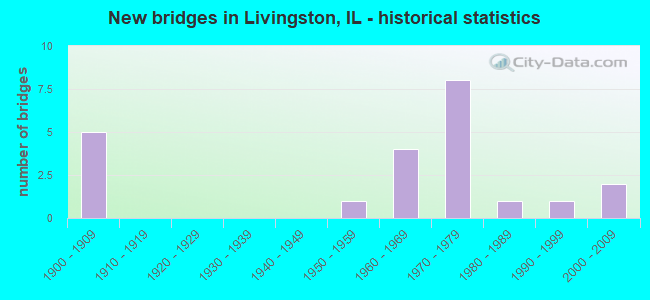
- New bridges - historical statistics
- 51900-1909
- 11950-1959
- 41960-1969
- 81970-1979
- 11980-1989
- 11990-1999
- 22000-2009

- Reconstructed bridges - Historical Statistics
- 11960-1969
- 11970-1979
- 11980-1989
- 01990-1999
- 02000-2009
- 02010-2019
- 12020-2022


- Bridge Condition - Deck
- 13.3%Very good
- 20.0%Good
- 20.0%Satisfactory
- 40.0%Fair
- 6.7%Poor

- Bridge Condition - Superstructure
- 13.3%Very good
- 20.0%Good
- 53.3%Fair
- 6.7%Poor
- 6.7%Serious

- Bridge Condition - Substructure
- 20.0%Very good
- 33.3%Good
- 26.7%Satisfactory
- 20.0%Fair

- Bridge Condition - Channel
- 21.4%Very good
- 7.1%Good
- 21.4%Satisfactory
- 50.0%Fair

- Bridge Condition - Culverts
- 25.0%Good
- 75.0%Satisfactory
Find on map >> Show street view
Structure Number: 450006, Location: 1 BLOCK W OF IL 25 (Lat: 42.020186, Lng: -88.269411), Route carried "on" structure: US 20, Year Built: 1960, Status: Temporarily open, Structure Length: 4.88m (16.01ft), Average Daily Traffic: 38,100 (year 2021), Truck Traffic: 16%, Average Future Daily Traffic: 54,996 (year 2032), Design Load: HS 20, Features Intersected: ST CHARLES ST
Minimum Vertical Clearance: 30+ m (98+ ft), Kilometerpoint: 233.799, Lanes on structure: 4, Lanes under structure: 4, Base Highway Network: Yes, Owner: State Highway Agency, Approaching Roadway Width: 19.8m (65.0ft), Skew: 30 degrees, Material/Design: Steel continuous, Design/Construction: Stringer/Multi-beam, Number Of Spans In Main Unit: 3, Length of Maximum Span: 24.4m (80.1ft), Curb-To-Curb Width: 15.8m (51.8ft), Out-to-Out Width: 15.8m (51.8ft)
Condition: Deck: Poor, Superstructure: Poor, Substructure: Good, Structural Evaluation: High priority of replacement, Deck Geometry: High priority of replacement, Underclear: Superior to present desirable criteria, Approach Roadway Alignment: Equal to present desirable criteria, Length Of Structure Improvement: 5.85m (19.19ft), Designated Inspection Frequency: Every 12 months, Other Special Inspection Frequency: Every 6 months, Inspection Date: December 2021, Other Special Inspection Date: December 2021, Bridge Improvement Cost: $1,283,000, Roadway Improvement Cost: $128,000, Total Project Cost: $1,925,000, Deck Structure Type: Concrete Cast-file-Place, Wearing Surface/Protective System: Wearing Surface: Other
Find on map >> Show street view
Structure Number: 450008, Location: 2.6 M W OF IL 31 (Lat: 42.031269, Lng: -88.334281), Route carried "on" structure: Other road , Year Built: 1961, Status: Open, Structure Length: 5.86m (19.23ft), Average Daily Traffic: 8,600 (year 2018), Truck Traffic: 4%, Average Future Daily Traffic: 6,189 (year 2032), Design Load: HS 20, Features Intersected: US 20 WB, Facility Carried by Structure: US 20 EB (LARKIN)
Minimum Vertical Clearance: 30+ m (98+ ft), Kilometerpoint: 0.177, Lanes on structure: 1, Lanes under structure: 2, Base Highway Network: Yes, Owner: State Highway Agency, Approaching Roadway Width: 7.9m (25.9ft), Skew: 4 degrees, Material/Design: Steel, Design/Construction: Stringer/Multi-beam, Number Of Spans In Main Unit: 3, Length of Maximum Span: 22.9m (75.1ft), Curb-To-Curb Width: 7.9m (25.9ft), Out-to-Out Width: 8.9m (29.2ft)
Condition: Deck: Satisfactory, Superstructure: Fair, Substructure: Good, Operating Rating: 67.1 metric tons, Method Used To Determine Operating Rating: Load Factor (LF) rating reported by rating factor (RF) method using MS18 loading, Inventory Rating: 40.2 metric tons, Method Used To Determine Inventory Rating: Load Factor (LF) rating reported by rating factor (RF) method using MS18 loading, Structural Evaluation: Somewhat better than minimum adequacy, Deck Geometry: High priority of replacement, Underclear: High priority of corrective action, Approach Roadway Alignment: Equal to present minimum criteria, Designated Inspection Frequency: Every 24 months, Inspection Date: April 2021, Deck Structure Type: Concrete Cast-file-Place, Wearing Surface/Protective System: Wearing Surface: Other
Find on map >> Show street view
Structure Number: 450009, Location: 2.9 M W OF IL 47 (Lat: 41.897633, Lng: -88.528922), Route carried "on" structure: State highway 38, Year Built: 1964, Year Reconstructed: 2020, Status: Open, Structure Length: 14.08m (46.19ft), Average Daily Traffic: 8,550 (year 2021), Truck Traffic: 6%, Average Future Daily Traffic: 10,272 (year 2032), Design Load: HS 20, Features Intersected: RR - UP
Minimum Vertical Clearance: 30+ m (98+ ft), Kilometerpoint: 88.286, Lanes on structure: 2, Base Highway Network: Yes, Owner: State Highway Agency, Approaching Roadway Width: 7.3m (24.0ft), Skew: 6 degrees, Material/Design: Steel continuous, Design/Construction: Stringer/Multi-beam, Number Of Spans In Main Unit: 5, Length of Maximum Span: 43.2m (141.7ft), Curb or Sidewalk Widths: Left: 0.6m (2.0ft), Right: 0.6m (2.0ft), Curb-To-Curb Width: 9.1m (29.9ft), Out-to-Out Width: 10.9m (35.8ft)
Condition: Deck: Good, Superstructure: Fair, Substructure: Good, Operating Rating: 61.2 metric tons, Method Used To Determine Operating Rating: Load Factor (LF) rating reported by rating factor (RF) method using MS18 loading, Inventory Rating: 36.6 metric tons, Method Used To Determine Inventory Rating: Load Factor (LF) rating reported by rating factor (RF) method using MS18 loading, Structural Evaluation: Somewhat better than minimum adequacy, Deck Geometry: Meets minimum limits, Underclear: Superior to present desirable criteria, Approach Roadway Alignment: Equal to present desirable criteria, Designated Inspection Frequency: Every 24 months, Other Special Inspection Frequency: Every 24 months, Inspection Date: October 2021, Other Special Inspection Date: October 2021, Deck Structure Type: Concrete Cast-file-Place, Wearing Surface/Protective System: Deck Protection: Epoxy Coated Reinforcing
Find on map >> Show street view
Structure Number: 600195, Location: 0.3 MI SE LIVINGSTON (Lat: 38.958614, Lng: -89.765597), Route carried "on" structure: County highway , Year Built: 1973, Status: Open, Structure Length: 10.45m (34.28ft), Average Daily Traffic: 525 (year 2021), Truck Traffic: 13%, Average Future Daily Traffic: 398 (year 2032), Design Load: HS 15, Features Intersected: I-55 & E FRONTAGE RD, Facility Carried by Structure: ALHAMBRA RD (FAS77
Minimum Vertical Clearance: 30+ m (98+ ft), Kilometerpoint: 0.290, Lanes on structure: 2, Lanes under structure: 6, Owner: State Highway Agency, Approaching Roadway Width: 9.1m (29.9ft), Skew: 1 degrees, Material/Design: Steel continuous, Design/Construction: Stringer/Multi-beam, Number Of Spans In Main Unit: 3, Length of Maximum Span: 33.5m (109.9ft), Curb-To-Curb Width: 8.7m (28.5ft), Out-to-Out Width: 9.8m (32.2ft)
Condition: Deck: Satisfactory, Superstructure: Good, Substructure: Satisfactory, Operating Rating: 73.5 metric tons, Method Used To Determine Operating Rating: Load Factor (LF) rating reported by rating factor (RF) method using MS18 loading, Inventory Rating: 38.6 metric tons, Method Used To Determine Inventory Rating: Load Factor (LF) rating reported by rating factor (RF) method using MS18 loading, Structural Evaluation: Equal to present minimum criteria, Deck Geometry: Somewhat better than minimum adequacy, Underclear: Equal to present minimum criteria, Approach Roadway Alignment: Equal to present desirable criteria, Designated Inspection Frequency: Every 24 months, Inspection Date: Febuary 2022, Deck Structure Type: Concrete Cast-file-Place, Wearing Surface/Protective System: Wearing Surface: Other
Find on map >> Show street view
Structure Number: 600198, Location: AT LIVINGSTON (Lat: 38.967539, Lng: -89.754214), Route carried "on" structure: County highway , Year Built: 1974, Status: Open, Structure Length: 7.19m (23.59ft), Average Daily Traffic: 1,550 (year 2021), Truck Traffic: 9%, Average Future Daily Traffic: 2,067 (year 2032), Design Load: HS 20, Features Intersected: FAI 55, Facility Carried by Structure: FAS777-LVNGSTN-ND
Minimum Vertical Clearance: 30+ m (98+ ft), Kilometerpoint: 4.587, Lanes on structure: 2, Lanes under structure: 4, Owner: State Highway Agency, Approaching Roadway Width: 20.1m (65.9ft), Skew: 33 degrees, Material/Design: Steel continuous, Design/Construction: Stringer/Multi-beam, Number Of Spans In Main Unit: 2, Number Of Approach Spans: 2, Length of Maximum Span: 35.7m (117.1ft), Curb-To-Curb Width: 19.7m (64.6ft), Out-to-Out Width: 20.7m (67.9ft)
Condition: Deck: Satisfactory, Superstructure: Good, Substructure: Satisfactory, Operating Rating: 67.7 metric tons, Method Used To Determine Operating Rating: Allowable Stress (AS) rating reported by rating factor (RF) method using MS18 loading, Inventory Rating: 36.9 metric tons, Method Used To Determine Inventory Rating: Allowable Stress (AS) rating reported by rating factor (RF) method using MS18 loading, Structural Evaluation: Equal to present minimum criteria, Deck Geometry: Superior to present desirable criteria, Underclear: High priority of corrective action, Approach Roadway Alignment: Equal to present desirable criteria, Designated Inspection Frequency: Every 24 months, Inspection Date: Febuary 2022, Deck Structure Type: Concrete Cast-file-Place, Wearing Surface/Protective System: Wearing Surface: Other
Find on map >> Show street view
Structure Number: 600235, Location: .6 MI EAST OF I-55 (Lat: 38.968447, Lng: -89.741300), Route carried "on" structure: County highway , Year Built: 2002, Status: Open, Structure Length: 2.88m (9.45ft), Average Daily Traffic: 1,700 (year 2021), Truck Traffic: 6%, Average Future Daily Traffic: 1,590 (year 2032), Design Load: HS 20, Features Intersected: TRIB. TO SILVER CRK, Facility Carried by Structure: FAS 777 NEW DOUGLA
Minimum Vertical Clearance: 30+ m (98+ ft), Kilometerpoint: 5.745, Lanes on structure: 2, Owner: State Highway Agency, Approaching Roadway Width: 7.9m (25.9ft), Skew: 3 degrees, Material/Design: Steel, Design/Construction: Stringer/Multi-beam, Number Of Spans In Main Unit: 1, Length of Maximum Span: 28.2m (92.5ft), Curb-To-Curb Width: 12.2m (40.0ft), Out-to-Out Width: 13.2m (43.3ft)
Condition: Deck: Very good, Superstructure: Very good, Substructure: Very good, Channel: Very good, Operating Rating: 84.6 metric tons, Method Used To Determine Operating Rating: Load Factor (LF) rating reported by rating factor (RF) method using MS18 loading, Inventory Rating: 50.9 metric tons, Method Used To Determine Inventory Rating: Load Factor (LF) rating reported by rating factor (RF) method using MS18 loading, Structural Evaluation: Equal to present desirable criteria, Deck Geometry: Better than present minimum criteria, Waterway Adequacy: Equal to present desirable criteria, Approach Roadway Alignment: Equal to present desirable criteria, Designated Inspection Frequency: Every 48 months, Inspection Date: August 2020, Deck Structure Type: Concrete Cast-file-Place, Wearing Surface/Protective System: Deck Protection: Epoxy Coated Reinforcing
Find on map >> Show street view
Structure Number: 600257, Location: 1.7 MI E. I-55 (Lat: 38.968419, Lng: -89.720661), Route carried "on" structure: County highway , Year Built: 1991, Status: Open, Structure Length: 3.85m (12.63ft), Average Daily Traffic: 1,400 (year 2021), Truck Traffic: 6%, Average Future Daily Traffic: 1,325 (year 2032), Design Load: HS 20, Features Intersected: SILVER CREEK, Facility Carried by Structure: LIVINGSTON ROAD
Minimum Vertical Clearance: 30+ m (98+ ft), Kilometerpoint: 7.548, Lanes on structure: 2, Owner: State Highway Agency, Approaching Roadway Width: 7.4m (24.3ft), Material/Design: Prestressed concrete, Design/Construction: Box Beam or Girders - Multiple, Number Of Spans In Main Unit: 3, Length of Maximum Span: 17.1m (56.1ft), Curb-To-Curb Width: 8.5m (27.9ft), Out-to-Out Width: 8.5m (27.9ft)
Condition: Deck: Fair, Superstructure: Fair, Substructure: Satisfactory, Channel: Very good, Operating Rating: 67.4 metric tons, Method Used To Determine Operating Rating: Load Factor (LF) rating reported by rating factor (RF) method using MS18 loading, Inventory Rating: 40.2 metric tons, Method Used To Determine Inventory Rating: Load Factor (LF) rating reported by rating factor (RF) method using MS18 loading, Structural Evaluation: Somewhat better than minimum adequacy, Deck Geometry: Somewhat better than minimum adequacy, Waterway Adequacy: Equal to present desirable criteria, Approach Roadway Alignment: Equal to present desirable criteria, Designated Inspection Frequency: Every 24 months, Inspection Date: August 2020, Deck Structure Type: Concrete Precast Panels, Wearing Surface/Protective System: Wearing Surface: Bituminous, Membrane: Built-up
Find on map >> Show street view
Structure Number: 602, Location: 0.45MI S ALHAMBRA RD (Lat: 38.955297, Lng: -89.769408), Route carried "on" structure: Interstate 55, Year Built: 1955, Year Reconstructed: 1973, Status: Open, Structure Length: 1.15m (3.77ft), Average Daily Traffic: 31,900 (year 2021), Truck Traffic: 27%, Average Future Daily Traffic: 27,454 (year 2032), Design Load: HS 20, Features Intersected: TRIB TO SILVER CREEK
Minimum Vertical Clearance: 30+ m (98+ ft), Kilometerpoint: 57.114, Lanes on structure: 4, Base Highway Network: Yes, Owner: State Highway Agency, Approaching Roadway Width: 26.8m (87.9ft), Skew: 14 degrees, Material/Design: Concrete continuous, Design/Construction: Culvert, Number Of Spans In Main Unit: 2, Length of Maximum Span: 5.2m (17.1ft)
Condition: Channel: Fair, Culverts: Satisfactory, Operating Rating: 74.5 metric tons, Method Used To Determine Operating Rating: Load Factor (LF) rating reported by rating factor (RF) method using MS18 loading, Inventory Rating: 44.7 metric tons, Method Used To Determine Inventory Rating: Load Factor (LF) rating reported by rating factor (RF) method using MS18 loading, Structural Evaluation: Equal to present minimum criteria, Waterway Adequacy: Equal to present desirable criteria, Approach Roadway Alignment: Equal to present desirable criteria, Designated Inspection Frequency: Every 24 months, Inspection Date: Febuary 2022
Find on map >> Show street view
Structure Number: 602016, Location: N OF NEW DOUGLAS RD (Lat: 38.969319, Lng: -89.751242), Route carried "on" structure: Interstate 55, Year Built: 1970, Status: Open, Structure Length: 0.71m (2.33ft), Average Daily Traffic: 30,300 (year 2021), Truck Traffic: 29%, Average Future Daily Traffic: 26,712 (year 2032), Design Load: HS 20+Mod, Features Intersected: TRIB TO SILVER CREEK
Minimum Vertical Clearance: 30+ m (98+ ft), Kilometerpoint: 59.496, Lanes on structure: 4, Base Highway Network: Yes, Owner: State Highway Agency, Approaching Roadway Width: 25.6m (84.0ft), Skew: 11 degrees, Material/Design: Concrete continuous, Design/Construction: Culvert, Number Of Spans In Main Unit: 2, Length of Maximum Span: 3.2m (10.5ft)
Condition: Channel: Fair, Culverts: Satisfactory, Operating Rating: 65.1 metric tons, Method Used To Determine Operating Rating: Load Factor (LF) rating reported by rating factor (RF) method using MS18 loading, Inventory Rating: 38.9 metric tons, Method Used To Determine Inventory Rating: Load Factor (LF) rating reported by rating factor (RF) method using MS18 loading, Structural Evaluation: Equal to present minimum criteria, Waterway Adequacy: Equal to present desirable criteria, Approach Roadway Alignment: Equal to present minimum criteria, Designated Inspection Frequency: Every 24 months, Inspection Date: Febuary 2022
Find on map >> Show street view
Structure Number: 602017, Location: SE FAI 55 LIVINGSTON (Lat: 38.966281, Lng: -89.748361), Route carried "on" structure: Other road , Year Built: 1973, Status: Open, Structure Length: 0.74m (2.43ft), Average Daily Traffic: 200 (year 2021), Truck Traffic: 11%, Average Future Daily Traffic: 159 (year 2032), Design Load: HS 20, Features Intersected: STREAM, Facility Carried by Structure: FAI 55 FR#1709
Minimum Vertical Clearance: 30+ m (98+ ft), Kilometerpoint: 2.044, Lanes on structure: 2, Owner: State Highway Agency, Approaching Roadway Width: 9.1m (29.9ft), Skew: 2 degrees, Material/Design: Concrete continuous, Design/Construction: Culvert, Number Of Spans In Main Unit: 2, Length of Maximum Span: 3.2m (10.5ft)
Condition: Channel: Fair, Culverts: Good, Operating Rating: 89.1 metric tons, Method Used To Determine Operating Rating: Field evaluation and documented engineering judgment, Inventory Rating: 89.1 metric tons, Method Used To Determine Inventory Rating: Field evaluation and documented engineering judgment, Structural Evaluation: Better than present minimum criteria, Waterway Adequacy: Superior to present desirable criteria, Approach Roadway Alignment: Equal to present desirable criteria, Designated Inspection Frequency: Every 24 months, Inspection Date: Febuary 2022
Find on map >> Show street view
Structure Number: 602028, Location: 1.5ME OF IL 4&LIV RD (Lat: 38.961389, Lng: -89.771972), Route carried "on" structure: County highway , Year Built: 1985, Status: Open, Structure Length: 1.25m (4.10ft), Average Daily Traffic: 525 (year 2018), Truck Traffic: 6%, Average Future Daily Traffic: 477 (year 2032), Design Load: HS 20, Features Intersected: TRIB TO SILVER CREEK, Facility Carried by Structure: FAS 777-LIV. ND RO
Minimum Vertical Clearance: 30+ m (98+ ft), Kilometerpoint: 2.543, Lanes on structure: 2, Owner: State Highway Agency, Approaching Roadway Width: 7.3m (24.0ft), Material/Design: Concrete continuous, Design/Construction: Culvert, Number Of Spans In Main Unit: 3, Length of Maximum Span: 3.4m (11.2ft)
Condition: Channel: Fair, Culverts: Satisfactory, Operating Rating: 56.4 metric tons, Method Used To Determine Operating Rating: Load Factor (LF) rating reported by rating factor (RF) method using MS18 loading, Inventory Rating: 33.7 metric tons, Method Used To Determine Inventory Rating: Load Factor (LF) rating reported by rating factor (RF) method using MS18 loading, Structural Evaluation: Equal to present minimum criteria, Waterway Adequacy: Equal to present minimum criteria, Approach Roadway Alignment: Equal to present desirable criteria, Designated Inspection Frequency: Every 24 months, Inspection Date: August 2020
Find on map >> Show street view
Structure Number: 603059, Location: 1.0 E LIVINGSTON (Lat: 38.972700, Lng: -89.740425), Route carried "on" structure: County highway , Year Built: 1901, Status: Open, Structure Length: 1.31m (4.30ft), Average Daily Traffic: 175 (year 2021), Truck Traffic: 13%, Average Future Daily Traffic: 133 (year 2032), Features Intersected: TRIB TO SILVER CK, Facility Carried by Structure: OLD HILLSBORO/ TR
Minimum Vertical Clearance: 30+ m (98+ ft), Kilometerpoint: 0.885, Lanes on structure: 1, Owner: Town or Township Highway Agency, Approaching Roadway Width: 4.9m (16.1ft), Material/Design: Concrete, Number Of Spans In Main Unit: 1, Length of Maximum Span: 12.2m (40.0ft), Curb-To-Curb Width: 5.4m (17.7ft), Out-to-Out Width: 5.5m (18.0ft)
Condition: Deck: Fair, Superstructure: Fair, Substructure: Fair, Channel: Satisfactory, Operating Rating: 32.4 metric tons, Method Used To Determine Operating Rating: Field evaluation and documented engineering judgment, Inventory Rating: 17.5 metric tons, Method Used To Determine Inventory Rating: Field evaluation and documented engineering judgment, Structural Evaluation: Somewhat better than minimum adequacy, Deck Geometry: High priority of replacement, Waterway Adequacy: Equal to present minimum criteria, Approach Roadway Alignment: Meets minimum limits, Length Of Structure Improvement: 1.31m (4.30ft), Designated Inspection Frequency: Every 24 months, Inspection Date: May 2021, Bridge Improvement Cost: $37,000, Roadway Improvement Cost: $4,000, Total Project Cost: $41,000, Deck Structure Type: Concrete Cast-file-Place, Wearing Surface/Protective System: Wearing Surface: Gravel
Find on map >> Show street view
Structure Number: 603063, Location: 2.0MI E LIVINGSTON (Lat: 38.965358, Lng: -89.718744), Route carried "on" structure: County highway , Year Built: 1901, Year Reconstructed: 1985, Status: Open, Structure Length: 1.58m (5.18ft), Average Daily Traffic: 50 (year 2021), Truck Traffic: 26%, Average Future Daily Traffic: 27 (year 2032), Features Intersected: SILVER CK, Facility Carried by Structure: LARCHER RD/ TR 49
Minimum Vertical Clearance: 30+ m (98+ ft), Kilometerpoint: 0.435, Lanes on structure: 1, Owner: Town or Township Highway Agency, Approaching Roadway Width: 3.7m (12.1ft), Material/Design: Steel, Design/Construction: Stringer/Multi-beam, Number Of Spans In Main Unit: 1, Length of Maximum Span: 14.9m (48.9ft), Curb-To-Curb Width: 5.7m (18.7ft), Out-to-Out Width: 5.9m (19.4ft)
Condition: Deck: Fair, Superstructure: Fair, Substructure: Good, Channel: Satisfactory, Operating Rating: 80.0 metric tons, Method Used To Determine Operating Rating: Allowable Stress (AS) rating reported by rating factor (RF) method using MS18 loading, Inventory Rating: 57.7 metric tons, Method Used To Determine Inventory Rating: Allowable Stress (AS) rating reported by rating factor (RF) method using MS18 loading, Structural Evaluation: Somewhat better than minimum adequacy, Deck Geometry: Meets minimum limits, Waterway Adequacy: Somewhat better than minimum adequacy, Approach Roadway Alignment: Meets minimum limits, Designated Inspection Frequency: Every 24 months, Inspection Date: May 2021, Deck Structure Type: Wood or Timber, Wearing Surface/Protective System: Wearing Surface: Wood or Timber
Find on map >> Show street view
Structure Number: 603067, Location: 1.0MI SE LIVINGSTON (Lat: 38.953917, Lng: -89.739558), Route carried "on" structure: County highway , Year Built: 1974, Status: Open, Structure Length: 1.89m (6.20ft), Average Daily Traffic: 100 (year 2021), Truck Traffic: 22%, Average Future Daily Traffic: 53 (year 2032), Design Load: HS 20, Features Intersected: TRIB TO SILVER CK, Facility Carried by Structure: LIBBRA RD/TR 67
Minimum Vertical Clearance: 30+ m (98+ ft), Kilometerpoint: 2.655, Lanes on structure: 1, Owner: Town or Township Highway Agency, Approaching Roadway Width: 5.8m (19.0ft), Material/Design: Prestressed concrete, Design/Construction: Box Beam or Girders - Multiple, Number Of Spans In Main Unit: 1, Length of Maximum Span: 18.3m (60.0ft), Curb-To-Curb Width: 6.9m (22.6ft), Out-to-Out Width: 7.5m (24.6ft)
Condition: Deck: Good, Superstructure: Good, Substructure: Very good, Channel: Satisfactory, Operating Rating: 44.4 metric tons, Method Used To Determine Operating Rating: Load Factor (LF) rating reported by rating factor (RF) method using MS18 loading, Inventory Rating: 32.4 metric tons, Method Used To Determine Inventory Rating: Load Factor (LF) rating reported by rating factor (RF) method using MS18 loading, Structural Evaluation: Better than present minimum criteria, Deck Geometry: Somewhat better than minimum adequacy, Waterway Adequacy: Better than present minimum criteria, Approach Roadway Alignment: Equal to present minimum criteria, Designated Inspection Frequency: Every 24 months, Inspection Date: May 2021, Deck Structure Type: Concrete Precast Panels, Wearing Surface/Protective System: Wearing Surface: Gravel
Find on map >> Show street view
Structure Number: 603074, Location: 1.5MI S LIVINGSTON (Lat: 38.939650, Lng: -89.775428), Route carried "on" structure: County highway , Year Built: 1901, Status: Open, Structure Length: 1.04m (3.41ft), Average Daily Traffic: 100 (year 2021), Truck Traffic: 13%, Average Future Daily Traffic: 106 (year 2032), Features Intersected: TRIB TO SILVER CK, Facility Carried by Structure: SILVER CRK RD/TR 1
Minimum Vertical Clearance: 30+ m (98+ ft), Kilometerpoint: 1.271, Lanes on structure: 1, Owner: Town or Township Highway Agency, Approaching Roadway Width: 4.3m (14.1ft), Material/Design: Concrete, Number Of Spans In Main Unit: 1, Length of Maximum Span: 9.1m (29.9ft), Curb-To-Curb Width: 5.2m (17.1ft), Out-to-Out Width: 6.3m (20.7ft)
Condition: Deck: Fair, Superstructure: Fair, Substructure: Satisfactory, Channel: Fair, Operating Rating: 32.4 metric tons, Method Used To Determine Operating Rating: Field evaluation and documented engineering judgment, Inventory Rating: 17.5 metric tons, Method Used To Determine Inventory Rating: Field evaluation and documented engineering judgment, Structural Evaluation: Somewhat better than minimum adequacy, Deck Geometry: High priority of corrective action, Waterway Adequacy: Equal to present minimum criteria, Approach Roadway Alignment: Equal to present minimum criteria, Designated Inspection Frequency: Every 24 months, Inspection Date: May 2021, Deck Structure Type: Concrete Cast-file-Place, Wearing Surface/Protective System: Wearing Surface: Gravel
Find on map >> Show street view
Structure Number: 603076, Location: 2.0MI SE LIVINGSTON (Lat: 38.940408, Lng: -89.734258), Route carried "on" structure: County highway , Year Built: 1901, Year Reconstructed: 1983, Status: Open, Structure Length: 1.71m (5.61ft), Average Daily Traffic: 125 (year 2021), Truck Traffic: 22%, Average Future Daily Traffic: 106 (year 2032), Features Intersected: SILVER CK, Facility Carried by Structure: SILVER CRK RD/TR 1
Minimum Vertical Clearance: 30+ m (98+ ft), Kilometerpoint: 4.924, Lanes on structure: 1, Owner: Town or Township Highway Agency, Approaching Roadway Width: 5.2m (17.1ft), Material/Design: Steel, Design/Construction: Stringer/Multi-beam, Number Of Spans In Main Unit: 1, Length of Maximum Span: 16.8m (55.1ft), Curb-To-Curb Width: 5.9m (19.4ft), Out-to-Out Width: 6.1m (20.0ft)
Condition: Deck: Good, Superstructure: Serious, Substructure: Fair, Channel: Good, Operating Rating: 38.9 metric tons, Method Used To Determine Operating Rating: Load Factor (LF) rating reported by rating factor (RF) method using MS18 loading, Inventory Rating: 26.2 metric tons, Method Used To Determine Inventory Rating: Load Factor (LF) rating reported by rating factor (RF) method using MS18 loading, Structural Evaluation: High priority of corrective action, Deck Geometry: High priority of corrective action, Waterway Adequacy: Meets minimum limits, Approach Roadway Alignment: Meets minimum limits, Designated Inspection Frequency: Every 24 months, Inspection Date: May 2021, Deck Structure Type: Wood or Timber, Wearing Surface/Protective System: Wearing Surface: Wood or Timber
Find on map >> Show street view
Structure Number: 603142, Location: 0.25MI W LIVINGSTON (Lat: 38.970339, Lng: -89.778161), Route carried "on" structure: County highway , Year Built: 1901, Status: Open, Structure Length: 1.01m (3.31ft), Average Daily Traffic: 150 (year 2021), Truck Traffic: 9%, Average Future Daily Traffic: 186 (year 2032), Features Intersected: TR1B TO SILVER CK, Facility Carried by Structure: TR 268
Minimum Vertical Clearance: 30+ m (98+ ft), Kilometerpoint: 0.628, Lanes on structure: 2, Owner: Town or Township Highway Agency, Approaching Roadway Width: 4.9m (16.1ft), Skew: 4 degrees, Material/Design: Concrete, Number Of Spans In Main Unit: 1, Length of Maximum Span: 9.8m (32.2ft), Curb-To-Curb Width: 6.2m (20.3ft), Out-to-Out Width: 6.6m (21.7ft)
Condition: Deck: Fair, Superstructure: Fair, Substructure: Fair, Channel: Fair, Operating Rating: 32.4 metric tons, Method Used To Determine Operating Rating: Field evaluation and documented engineering judgment, Inventory Rating: 17.5 metric tons, Method Used To Determine Inventory Rating: Field evaluation and documented engineering judgment, Structural Evaluation: Somewhat better than minimum adequacy, Deck Geometry: Meets minimum limits, Waterway Adequacy: Better than present minimum criteria, Approach Roadway Alignment: Meets minimum limits, Designated Inspection Frequency: Every 24 months, Inspection Date: May 2021, Deck Structure Type: Concrete Cast-file-Place, Wearing Surface/Protective System: Wearing Surface: Gravel
Find on map >> Show street view
Structure Number: 603211, Location: 1.5MI S LIVINGSTON (Lat: 38.939589, Lng: -89.771881), Route carried "on" structure: County highway , Year Built: 1969, Status: Open, Structure Length: 1.28m (4.20ft), Average Daily Traffic: 100 (year 2021), Truck Traffic: 13%, Average Future Daily Traffic: 106 (year 2032), Design Load: HS 20, Features Intersected: TR1B TO SILVER CK, Facility Carried by Structure: SILVER CRK RD/TR 1
Minimum Vertical Clearance: 30+ m (98+ ft), Kilometerpoint: 1.577, Lanes on structure: 2, Owner: Town or Township Highway Agency, Approaching Roadway Width: 4.9m (16.1ft), Skew: 3 degrees, Material/Design: Prestressed concrete, Design/Construction: Box Beam or Girders - Multiple, Number Of Spans In Main Unit: 1, Length of Maximum Span: 11.8m (38.7ft), Curb-To-Curb Width: 7.3m (24.0ft), Out-to-Out Width: 7.9m (25.9ft)
Condition: Deck: Fair, Superstructure: Fair, Substructure: Good, Channel: Fair, Operating Rating: 52.8 metric tons, Method Used To Determine Operating Rating: Load Factor (LF) rating reported by rating factor (RF) method using MS18 loading, Inventory Rating: 31.8 metric tons, Method Used To Determine Inventory Rating: Load Factor (LF) rating reported by rating factor (RF) method using MS18 loading, Structural Evaluation: Somewhat better than minimum adequacy, Deck Geometry: Equal to present minimum criteria, Waterway Adequacy: Equal to present desirable criteria, Approach Roadway Alignment: Equal to present desirable criteria, Designated Inspection Frequency: Every 24 months, Inspection Date: May 2021, Deck Structure Type: Concrete Precast Panels, Wearing Surface/Protective System: Wearing Surface: Gravel
Find on map >> Show street view
Structure Number: 603347, Location: 1.5MI SE LIVINGSTON (Lat: 38.953775, Lng: -89.730289), Route carried "on" structure: County highway , Year Built: 2009, Status: Open, Structure Length: 5.53m (18.14ft), Average Daily Traffic: 100 (year 2021), Truck Traffic: 22%, Average Future Daily Traffic: 80 (year 2032), Design Load: HS 20+Mod, Features Intersected: SILVER CK, Facility Carried by Structure: LIBBRA RD/TR67
Minimum Vertical Clearance: 30+ m (98+ ft), Kilometerpoint: 3.460, Lanes on structure: 2, Owner: Town or Township Highway Agency, Approaching Roadway Width: 7.0m (23.0ft), Material/Design: Prestressed concrete, Design/Construction: Box Beam or Girders - Multiple, Number Of Spans In Main Unit: 3, Length of Maximum Span: 18.3m (60.0ft), Curb-To-Curb Width: 9.2m (30.2ft), Out-to-Out Width: 9.2m (30.2ft)
Condition: Deck: Very good, Superstructure: Very good, Substructure: Very good, Channel: Very good, Operating Rating: 44.1 metric tons, Method Used To Determine Operating Rating: Assigned rating based on Load Factor Design (LFD) reported by rating factor (RF) using MS18 loading, Inventory Rating: 32.4 metric tons, Method Used To Determine Inventory Rating: Assigned rating based on Load Factor Design (LFD) reported by rating factor (RF) using MS18 loading, Structural Evaluation: Equal to present desirable criteria, Deck Geometry: Better than present minimum criteria, Waterway Adequacy: Equal to present minimum criteria, Approach Roadway Alignment: Equal to present desirable criteria, Designated Inspection Frequency: Every 48 months, Inspection Date: May 2021, Deck Structure Type: Concrete Precast Panels, Wearing Surface/Protective System: Wearing Surface: Bituminous, Membrane: Built-up
Find on map >> Show street view
Structure Number: 600195, Location: 0.3 MI SE LIVINGSTON (Lat: 38.958361, Lng: -89.765369), Route carried "under" structure: Interstate 55, Year Built: 1973, Structure Length: 0. m, Average Daily Traffic: 31,900 (year 2021), Truck Traffic: 27%, Features Intersected: I-55 & E FRONTAGE RD, Facility Carried by Structure: ALHAMBRA RD (FAS77
Minimum Vertical Clearance: 5.03m (16.50ft), Kilometerpoint: 57.613, Lanes on structure: 2, Lanes under structure: 4, Material/Design: Steel continuous, Design/Construction: Stringer/Multi-beam, Length of Maximum Span: 33.5m (109.9ft)
Find on map >> Show street view
Structure Number: 600195, Location: 0.3 MI SE LIVINGSTON (Lat: 38.958819, Lng: -89.765781), Route carried "under" structure: Other road , Year Built: 1973, Structure Length: 0. m, Average Daily Traffic: 575 (year 2021), Truck Traffic: 7%, Features Intersected: I-55 & E FRONTAGE RD, Facility Carried by Structure: ALHAMBRA RD (FAS77
Minimum Vertical Clearance: 5.46m (17.91ft), Kilometerpoint: 4.120, Lanes on structure: 2, Lanes under structure: 2, Material/Design: Steel continuous, Design/Construction: Stringer/Multi-beam, Length of Maximum Span: 33.5m (109.9ft)
Find on map >> Show street view
Structure Number: 600198, Location: AT LIVINGSTON (Lat: 38.967403, Lng: -89.753489), Route carried "under" structure: Interstate 55, Year Built: 1974, Structure Length: 0. m, Average Daily Traffic: 30,300 (year 2021), Truck Traffic: 29%, Features Intersected: FAI 55, Facility Carried by Structure: FAS777-LVNGSTN-ND
Minimum Vertical Clearance: 5.08m (16.67ft), Kilometerpoint: 59.093, Lanes on structure: 2, Lanes under structure: 4, Material/Design: Steel continuous, Design/Construction: Stringer/Multi-beam, Length of Maximum Span: 35.7m (117.1ft)