Bridge Statistics for Litchfield, Michigan (MI)
Condition, Traffic, Stress, Structural Evaluation, Project Costs
- National Bridge Inventory (NBI) Statistics
- 14Number of bridges
- 62ft / 18.9mTotal length
- $34,000Total costs
- 9,704Total average daily traffic
- 778Total average daily truck traffic
- 17,448Total future (year 2018) average daily traffic
- National Bridge Inventory (NBI) Registered Bridges for Litchfield
- No street view available for this location
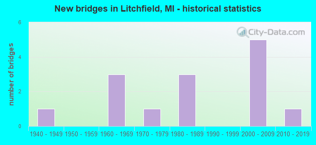
- New bridges - historical statistics
- 11940-1949
- 31960-1969
- 11970-1979
- 31980-1989
- 52000-2009
- 12010-2019


- Bridge Condition - Deck
- 83.3%Good
- 16.7%Satisfactory

- Bridge Condition - Superstructure
- 16.7%Very good
- 83.3%Good

- Bridge Condition - Substructure
- 16.7%Very good
- 83.3%Good

- Bridge Condition - Channel
- 28.6%Very good
- 35.7%Good
- 35.7%Satisfactory

- Bridge Condition - Culverts
- 25.0%Good
- 62.5%Satisfactory
- 12.5%Serious
Find on map >> Show street view
Structure Number: 3261, Location: IN LITCHFIELD (Lat: 42.041333, Lng: -84.758394), Route carried "on" structure: State highway 49, Year Built: 1949, Status: Open, Structure Length: 1.98m (6.50ft), Average Daily Traffic: 1,900 (year 2008), Truck Traffic: 9%, Average Future Daily Traffic: 2,320 (year 2028), Design Load: HS 20, Features Intersected: ST JOSEPH RIVER
Minimum Vertical Clearance: 30.48m (100.00ft), Kilometerpoint: 9.924, Lanes on structure: 2, Base Highway Network: Yes (Inventory Route: 330, Subroute: 1), Owner: State Highway Agency, Approaching Roadway Width: 8.5m (27.9ft), Skew: 2 degrees, Material/Design: Steel, Design/Construction: Stringer/Multi-beam, Number Of Spans In Main Unit: 1, Length of Maximum Span: 19.8m (65.0ft), Curb or Sidewalk Widths: Left: 1.6m (5.2ft), Right: 1.6m (5.2ft), Curb-To-Curb Width: 8.5m (27.9ft), Out-to-Out Width: 12.6m (41.3ft)
Condition: Deck: Satisfactory, Superstructure: Good, Substructure: Good, Channel: Very good, Inventory Rating: 82.6 metric tons, Method Used To Determine Inventory Rating: Load Factor (LF), Structural Evaluation: Better than present minimum criteria, Deck Geometry: Somewhat better than minimum adequacy, Waterway Adequacy: Equal to present desirable criteria, Approach Roadway Alignment: Equal to present desirable criteria, Length Of Structure Improvement: 1.98m (6.50ft), Designated Inspection Frequency: Every 24 months, Inspection Date: May 2020, Bridge Improvement Cost: $29,000, Roadway Improvement Cost: $3,000, Total Project Cost: $34,000, Deck Structure Type: Concrete Cast-file-Place, Wearing Surface/Protective System: Wearing Surface: Latex Concrete
Find on map >> Show street view
Structure Number: 3262, Location: 3.1 M S OF LITCHFIELD (Lat: 42.000042, Lng: -84.745400), Route carried "on" structure: County highway , Year Built: 2002, Status: Open, Structure Length: 1.10m (3.61ft), Average Daily Traffic: 71 (year 2014), Truck Traffic: 17%, Average Future Daily Traffic: 116 (year 2038), Design Load: HS 20, Features Intersected: SAND CREEK, Facility Carried by Structure: GENESEE RD
Minimum Vertical Clearance: 30.48m (100.00ft), Kilometerpoint: 0.043, Lanes on structure: 2, Base Highway Network: Yes (Inventory Route: 330, Subroute: 74), Owner: County Highway Agency, Approaching Roadway Width: 11.0m (36.1ft), Material/Design: Concrete, Design/Construction: Culvert, Number Of Spans In Main Unit: 1, Length of Maximum Span: 11.0m (36.1ft), Curb-To-Curb Width: 8.5m (27.9ft), Out-to-Out Width: 16.4m (53.8ft)
Condition: Channel: Very good, Culverts: Satisfactory, Operating Rating: 54.6 metric tons, Method Used To Determine Operating Rating: Field evaluation and documented engineering judgment, Inventory Rating: 32.7 metric tons, Method Used To Determine Inventory Rating: Field evaluation and documented engineering judgment, Structural Evaluation: Equal to present minimum criteria, Deck Geometry: Better than present minimum criteria, Waterway Adequacy: Equal to present desirable criteria, Approach Roadway Alignment: Equal to present desirable criteria, Designated Inspection Frequency: Every 24 months, Inspection Date: November 2020, Wearing Surface/Protective System: Wearing Surface: Bituminous
Find on map >> Show street view
Structure Number: 3302, Location: 0.7 MILE WEST OF M-49 (Lat: 42.014714, Lng: -84.771536), Route carried "on" structure: County highway , Year Built: 1965, Status: Open, Structure Length: 0.94m (3.08ft), Average Daily Traffic: 465 (year 2013), Average Future Daily Traffic: 763 (year 2038), Design Load: HS 20+Mod, Features Intersected: SAND CREEK, Facility Carried by Structure: STERLING ROAD
Minimum Vertical Clearance: 30.48m (100.00ft), Kilometerpoint: 4.524, Lanes on structure: 2, Owner: County Highway Agency, Approaching Roadway Width: 10.1m (33.1ft), Skew: 1 degrees, Material/Design: Steel, Design/Construction: Culvert, Number Of Spans In Main Unit: 2, Length of Maximum Span: 3.9m (12.8ft)
Condition: Channel: Satisfactory, Culverts: Satisfactory, Operating Rating: 97.2 metric tons, Method Used To Determine Operating Rating: Load Factor (LF) rating reported by rating factor (RF) method using MS18 loading, Inventory Rating: 65.1 metric tons, Method Used To Determine Inventory Rating: Load Factor (LF) rating reported by rating factor (RF) method using MS18 loading, Structural Evaluation: Equal to present minimum criteria, Waterway Adequacy: Equal to present desirable criteria, Approach Roadway Alignment: Better than present minimum criteria, Designated Inspection Frequency: Every 24 months, Inspection Date: November 2020, Wearing Surface/Protective System: Wearing Surface: Bituminous
Find on map >> Show street view
Structure Number: 3303, Location: 0.1 MILE E OF HADLEY RD (Lat: 42.043864, Lng: -84.803347), Route carried "on" structure: County highway 3094, Year Built: 2015, Status: Open, Structure Length: 1.16m (3.81ft), Average Daily Traffic: 988 (year 2015), Truck Traffic: 2%, Average Future Daily Traffic: 1,800 (year 2035), Design Load: Greater than HL93, Features Intersected: SAND CREEK, Facility Carried by Structure: LITCHFIELD ROAD
Minimum Vertical Clearance: 30.48m (100.00ft), Kilometerpoint: 1.891, Lanes on structure: 2, Owner: County Highway Agency, Approaching Roadway Width: 10.4m (34.1ft), Material/Design: Prestressed concrete, Design/Construction: Box Beam or Girders - Multiple, Number Of Spans In Main Unit: 1, Length of Maximum Span: 11.2m (36.7ft), Curb-To-Curb Width: 10.5m (34.4ft), Out-to-Out Width: 11.6m (38.1ft)
Condition: Deck: Good, Superstructure: Very good, Substructure: Good, Channel: Very good, Operating Rating: 82.6 metric tons, Method Used To Determine Operating Rating: Load and Resistance Factor Rating (LRFR) rating reported by rating factor(RF) method using HL-93 loadings, Inventory Rating: 63.8 metric tons, Method Used To Determine Inventory Rating: Load and Resistance Factor Rating (LRFR) rating reported by rating factor(RF) method using HL-93 loadings, Structural Evaluation: Better than present minimum criteria, Deck Geometry: Equal to present minimum criteria, Waterway Adequacy: Equal to present desirable criteria, Approach Roadway Alignment: Equal to present desirable criteria, Designated Inspection Frequency: Every 24 months, Inspection Date: November 2020, Deck Structure Type: Concrete Cast-file-Place, Wearing Surface/Protective System: Wearing Surface: Monolithic Concrete, Deck Protection: Epoxy Coated Reinforcing
Find on map >> Show street view
Structure Number: 3304, Location: 0.25 MI E OF FRENCH RD (Lat: 42.043589, Lng: -84.690608), Route carried "on" structure: County highway 3094, Year Built: 1963, Status: Open, Structure Length: 0.67m (2.20ft), Average Daily Traffic: 1,136 (year 2013), Average Future Daily Traffic: 1,864 (year 2038), Design Load: HS 20+Mod, Features Intersected: CONGER DRAIN, Facility Carried by Structure: LITCHFIELD ROAD
Minimum Vertical Clearance: 30.48m (100.00ft), Kilometerpoint: 11.222, Lanes on structure: 2, Owner: County Highway Agency, Approaching Roadway Width: 7.9m (25.9ft), Material/Design: Steel, Design/Construction: Culvert, Number Of Spans In Main Unit: 3, Length of Maximum Span: 1.8m (5.9ft), Curb-To-Curb Width: 7.9m (25.9ft), Out-to-Out Width: 7.9m (25.9ft)
Condition: Channel: Satisfactory, Culverts: Satisfactory, Operating Rating: 68.7 metric tons, Method Used To Determine Operating Rating: Load Factor (LF) rating reported by rating factor (RF) method using MS18 loading, Inventory Rating: 41.1 metric tons, Method Used To Determine Inventory Rating: Load Factor (LF) rating reported by rating factor (RF) method using MS18 loading, Structural Evaluation: Equal to present minimum criteria, Deck Geometry: Meets minimum limits, Waterway Adequacy: Equal to present minimum criteria, Approach Roadway Alignment: Equal to present desirable criteria, Designated Inspection Frequency: Every 24 months, Inspection Date: November 2020, Wearing Surface/Protective System: Wearing Surface: Bituminous
Find on map >> Show street view
Structure Number: 3335, Location: 0.2 MILE W OF ALLEN RD (Lat: 42.000164, Lng: -84.777911), Route carried "on" structure: Alternate County highway , Year Built: 1982, Status: Open, Structure Length: 0.64m (2.10ft), Average Daily Traffic: 42 (year 2014), Average Future Daily Traffic: 69 (year 2038), Design Load: HS 20+Mod, Features Intersected: SOAP CREEK, Facility Carried by Structure: GENESEE ROAD
Minimum Vertical Clearance: 30.48m (100.00ft), Kilometerpoint: 3.996, Lanes on structure: 2, Owner: County Highway Agency, Approaching Roadway Width: 7.3m (24.0ft), Skew: 3 degrees, Material/Design: Steel, Design/Construction: Culvert, Number Of Spans In Main Unit: 2, Length of Maximum Span: 2.7m (8.9ft), Curb-To-Curb Width: 7.3m (24.0ft), Out-to-Out Width: 9.4m (30.8ft)
Condition: Channel: Satisfactory, Culverts: Satisfactory, Operating Rating: 45.0 metric tons, Method Used To Determine Operating Rating: Load Factor (LF) rating reported by rating factor (RF) method using MS18 loading, Inventory Rating: 26.9 metric tons, Method Used To Determine Inventory Rating: Load Factor (LF) rating reported by rating factor (RF) method using MS18 loading, Structural Evaluation: Equal to present minimum criteria, Deck Geometry: Equal to present minimum criteria, Waterway Adequacy: Equal to present desirable criteria, Approach Roadway Alignment: Better than present minimum criteria, Designated Inspection Frequency: Every 24 months, Inspection Date: November 2020, Wearing Surface/Protective System: Wearing Surface: Gravel
Find on map >> Show street view
Structure Number: 3336, Location: 0.4 MILE W OF RAINEY RD (Lat: 41.999947, Lng: -84.717353), Route carried "on" structure: County highway , Year Built: 1987, Status: Open, Structure Length: 0.79m (2.59ft), Average Daily Traffic: 51 (year 2014), Average Future Daily Traffic: 84 (year 2038), Design Load: HS 20+Mod, Features Intersected: TRIB TO ST JOSEPH RIVER, Facility Carried by Structure: GENESEE ROAD
Minimum Vertical Clearance: 30.48m (100.00ft), Kilometerpoint: 3.425, Lanes on structure: 2, Owner: County Highway Agency, Approaching Roadway Width: 9.8m (32.2ft), Skew: 1 degrees, Material/Design: Steel, Design/Construction: Culvert, Number Of Spans In Main Unit: 3, Length of Maximum Span: 3.0m (9.8ft)
Condition: Channel: Good, Culverts: Good, Operating Rating: 41.5 metric tons, Method Used To Determine Operating Rating: Load Factor (LF) rating reported by rating factor (RF) method using MS18 loading, Inventory Rating: 24.9 metric tons, Method Used To Determine Inventory Rating: Load Factor (LF) rating reported by rating factor (RF) method using MS18 loading, Structural Evaluation: Equal to present minimum criteria, Waterway Adequacy: Equal to present desirable criteria, Approach Roadway Alignment: Equal to present desirable criteria, Designated Inspection Frequency: Every 24 months, Inspection Date: November 2020, Wearing Surface/Protective System: Wearing Surface: Gravel
Find on map >> Show street view
Structure Number: 3337, Location: 0.2 MILE E OF CRONK ROAD (Lat: 42.014481, Lng: -84.720975), Route carried "on" structure: Alternate County highway , Year Built: 2000, Status: Open, Structure Length: 3.40m (11.15ft), Average Daily Traffic: 74 (year 2014), Average Future Daily Traffic: 121 (year 2038), Design Load: HS 20, Features Intersected: ST JOSEPH RIVER, Facility Carried by Structure: STERLING ROAD
Minimum Vertical Clearance: 30.48m (100.00ft), Kilometerpoint: 8.712, Lanes on structure: 2, Owner: County Highway Agency, Approaching Roadway Width: 7.9m (25.9ft), Skew: 4 degrees, Material/Design: Prestressed concrete, Design/Construction: Box Beam or Girders - Multiple, Number Of Spans In Main Unit: 1, Length of Maximum Span: 33.6m (110.2ft), Curb-To-Curb Width: 8.8m (28.9ft), Out-to-Out Width: 8.9m (29.2ft)
Condition: Deck: Good, Superstructure: Good, Substructure: Good, Channel: Satisfactory, Operating Rating: 99.0 metric tons, Method Used To Determine Operating Rating: Load Factor (LF), Inventory Rating: 80.7 metric tons, Method Used To Determine Inventory Rating: Load Factor (LF), Structural Evaluation: Better than present minimum criteria, Deck Geometry: Better than present minimum criteria, Waterway Adequacy: Equal to present desirable criteria, Approach Roadway Alignment: Equal to present desirable criteria, Designated Inspection Frequency: Every 24 months, Inspection Date: November 2020, Deck Structure Type: Concrete Cast-file-Place, Wearing Surface/Protective System: Wearing Surface: Monolithic Concrete, Deck Protection: Epoxy Coated Reinforcing
Find on map >> Show street view
Structure Number: 3338, Location: 0.4 MI E OF MCLAIN ROAD (Lat: 42.029253, Lng: -84.779597), Route carried "on" structure: Alternate County highway , Year Built: 1979, Status: Open, Structure Length: 0.79m (2.59ft), Average Daily Traffic: 129 (year 2014), Average Future Daily Traffic: 212 (year 2038), Design Load: HS 20+Mod, Features Intersected: SAND CREEK, Facility Carried by Structure: HERRING ROAD
Minimum Vertical Clearance: 30.48m (100.00ft), Kilometerpoint: 3.859, Lanes on structure: 2, Owner: County Highway Agency, Approaching Roadway Width: 9.4m (30.8ft), Skew: 1 degrees, Material/Design: Steel, Design/Construction: Culvert, Number Of Spans In Main Unit: 2, Length of Maximum Span: 3.6m (11.8ft), Curb-To-Curb Width: 9.1m (29.9ft), Out-to-Out Width: 9.1m (29.9ft)
Condition: Channel: Good, Culverts: Satisfactory, Operating Rating: 46.7 metric tons, Method Used To Determine Operating Rating: Load Factor (LF) rating reported by rating factor (RF) method using MS18 loading, Inventory Rating: 27.9 metric tons, Method Used To Determine Inventory Rating: Load Factor (LF) rating reported by rating factor (RF) method using MS18 loading, Structural Evaluation: Equal to present minimum criteria, Deck Geometry: Equal to present minimum criteria, Waterway Adequacy: Equal to present desirable criteria, Approach Roadway Alignment: Better than present minimum criteria, Designated Inspection Frequency: Every 24 months, Inspection Date: November 2020, Wearing Surface/Protective System: Wearing Surface: Gravel
Find on map >> Show street view
Structure Number: 3339, Location: 0.2 MILE W OF CRONK RD (Lat: 42.029081, Lng: -84.732964), Route carried "on" structure: Alternate County highway , Year Built: 2002, Status: Open, Structure Length: 1.92m (6.30ft), Average Daily Traffic: 1,673 (year 2013), Truck Traffic: 15%, Average Future Daily Traffic: 2,745 (year 2038), Design Load: HS 20, Features Intersected: ST JOSEPH RIVER, Facility Carried by Structure: HERRING ROAD
Minimum Vertical Clearance: 30.48m (100.00ft), Kilometerpoint: 7.720, Lanes on structure: 2, Owner: County Highway Agency, Approaching Roadway Width: 9.1m (29.9ft), Skew: 1 degrees, Material/Design: Prestressed concrete, Design/Construction: Box Beam or Girders - Multiple, Number Of Spans In Main Unit: 1, Length of Maximum Span: 19.2m (63.0ft), Curb-To-Curb Width: 9.4m (30.8ft), Out-to-Out Width: 9.5m (31.2ft)
Condition: Deck: Good, Superstructure: Good, Substructure: Very good, Channel: Good, Operating Rating: 99.0 metric tons, Method Used To Determine Operating Rating: Load Factor (LF), Inventory Rating: 60.6 metric tons, Method Used To Determine Inventory Rating: Load Factor (LF), Structural Evaluation: Better than present minimum criteria, Deck Geometry: Somewhat better than minimum adequacy, Waterway Adequacy: Equal to present desirable criteria, Approach Roadway Alignment: Equal to present desirable criteria, Designated Inspection Frequency: Every 24 months, Inspection Date: November 2020, Deck Structure Type: Concrete Cast-file-Place, Wearing Surface/Protective System: Wearing Surface: Monolithic Concrete, Deck Protection: Epoxy Coated Reinforcing
Find on map >> Show street view
Structure Number: 3342, Location: 0.3 MI S OF HERRING RD (Lat: 42.023125, Lng: -84.729017), Route carried "on" structure: Alternate County highway , Year Built: 1987, Status: Open, Structure Length: 1.82m (5.97ft), Average Daily Traffic: 130 (year 2014), Average Future Daily Traffic: 213 (year 2038), Design Load: HS 20, Features Intersected: ST JOSEPH RIVER, Facility Carried by Structure: CRONK ROAD
Minimum Vertical Clearance: 30.48m (100.00ft), Kilometerpoint: 13.899, Lanes on structure: 2, Owner: County Highway Agency, Approaching Roadway Width: 8.2m (26.9ft), Material/Design: Prestressed concrete, Design/Construction: Box Beam or Girders - Multiple, Number Of Spans In Main Unit: 1, Length of Maximum Span: 17.6m (57.7ft), Curb-To-Curb Width: 9.1m (29.9ft), Out-to-Out Width: 9.4m (30.8ft)
Condition: Deck: Good, Superstructure: Good, Substructure: Good, Channel: Good, Operating Rating: 53.3 metric tons, Method Used To Determine Operating Rating: Load Factor (LF), Inventory Rating: 32.0 metric tons, Method Used To Determine Inventory Rating: Load Factor (LF), Structural Evaluation: Better than present minimum criteria, Deck Geometry: Equal to present minimum criteria, Waterway Adequacy: Equal to present desirable criteria, Approach Roadway Alignment: Equal to present desirable criteria, Designated Inspection Frequency: Every 24 months, Inspection Date: November 2020, Deck Structure Type: Concrete Precast Panels, Wearing Surface/Protective System: Wearing Surface: Bituminous, Deck Protection: Epoxy Coated Reinforcing
Find on map >> Show street view
Structure Number: 3343, Location: 0.1 MI N OF STERLING RD (Lat: 42.016050, Lng: -84.826200), Route carried "on" structure: Alternate County highway , Year Built: 1960, Status: Posted for load, Structure Length: 0.73m (2.40ft), Average Daily Traffic: 96 (year 2014), Average Future Daily Traffic: 157 (year 2038), Design Load: HS 20+Mod, Features Intersected: SOAP CREEK, Facility Carried by Structure: SQUIRES ROAD
Minimum Vertical Clearance: 30.48m (100.00ft), Kilometerpoint: 7.487, Lanes on structure: 2, Owner: County Highway Agency, Approaching Roadway Width: 7.6m (24.9ft), Skew: 3 degrees, Material/Design: Steel, Design/Construction: Culvert, Number Of Spans In Main Unit: 2, Length of Maximum Span: 3.0m (9.8ft), Curb-To-Curb Width: 6.7m (22.0ft), Out-to-Out Width: 6.7m (22.0ft)
Condition: Channel: Satisfactory, Culverts: Serious, Operating Rating: 14.6 metric tons, Method Used To Determine Operating Rating: Load Factor (LF) rating reported by rating factor (RF) method using MS18 loading, Inventory Rating: 8.7 metric tons, Method Used To Determine Inventory Rating: Load Factor (LF) rating reported by rating factor (RF) method using MS18 loading, Structural Evaluation: High priority of corrective action, Deck Geometry: Somewhat better than minimum adequacy, Waterway Adequacy: Somewhat better than minimum adequacy, Approach Roadway Alignment: Better than present minimum criteria, Bridge Posting: Required (Relationship of Operating Rating to Maximum Legal Load: > 39.9% below), Designated Inspection Frequency: Every 12 months, Inspection Date: November 2021, Wearing Surface/Protective System: Wearing Surface: Gravel
Find on map >> Show street view
Structure Number: 3376, Location: IN LITCHFIELD W. OF M-49 (Lat: 42.043889, Lng: -84.764353), Route carried "on" structure: City street 3094, Year Built: 2002, Status: Open, Structure Length: 1.78m (5.84ft), Average Daily Traffic: 1,450 (year 2004), Truck Traffic: 5%, Average Future Daily Traffic: 1,920 (year 2018), Design Load: HS 25 or greater, Features Intersected: NO. BR. ST. JOSEPH RIVER, Facility Carried by Structure: ST. JOSEPH STREET
Minimum Vertical Clearance: 30.48m (100.00ft), Kilometerpoint: 5.120, Lanes on structure: 2, Owner: City or Municipal Highway Agency, Approaching Roadway Width: 11.3m (37.1ft), Skew: 3 degrees, Material/Design: Prestressed concrete, Design/Construction: Box Beam or Girders - Single/Spread, Number Of Spans In Main Unit: 1, Length of Maximum Span: 17.8m (58.4ft), Curb-To-Curb Width: 11.3m (37.1ft), Out-to-Out Width: 12.3m (40.4ft)
Condition: Deck: Good, Superstructure: Good, Substructure: Good, Channel: Good, Operating Rating: 85.0 metric tons, Method Used To Determine Operating Rating: Load Factor (LF), Inventory Rating: 51.0 metric tons, Method Used To Determine Inventory Rating: Load Factor (LF), Structural Evaluation: Better than present minimum criteria, Deck Geometry: Equal to present minimum criteria, Waterway Adequacy: Equal to present desirable criteria, Approach Roadway Alignment: Equal to present desirable criteria, Designated Inspection Frequency: Every 24 months, Inspection Date: August 2020, Deck Structure Type: Concrete Cast-file-Place, Wearing Surface/Protective System: Wearing Surface: Monolithic Concrete, Deck Protection: Epoxy Coated Reinforcing
Find on map >> Show street view
Structure Number: 1306, Location: 3.1 MI S OF LITCHFIELD (Lat: 42.000083, Lng: -84.758269), Route carried "on" structure: State highway 49, Year Built: 2001, Status: Open, Structure Length: 1.17m (3.84ft), Average Daily Traffic: 1,499 (year 2007), Truck Traffic: 17%, Average Future Daily Traffic: 5,064 (year 2022), Design Load: HS 25 or greater, Features Intersected: SAND CREEK
Minimum Vertical Clearance: 30.48m (100.00ft), Kilometerpoint: 5.427, Lanes on structure: 3, Base Highway Network: Yes (Inventory Route: 330, Subroute: 1), Owner: State Highway Agency, Approaching Roadway Width: 9.8m (32.2ft), Material/Design: Concrete, Design/Construction: Culvert, Number Of Spans In Main Unit: 1, Length of Maximum Span: 11.0m (36.1ft), Curb-To-Curb Width: 19.5m (64.0ft), Out-to-Out Width: 20.5m (67.3ft)
Condition: Channel: Very good, Culverts: Good, Operating Rating: 97.2 metric tons, Method Used To Determine Operating Rating: Load Factor (LF) rating reported by rating factor (RF) method using MS18 loading, Inventory Rating: 93.3 metric tons, Method Used To Determine Inventory Rating: Load Factor (LF) rating reported by rating factor (RF) method using MS18 loading, Structural Evaluation: Better than present minimum criteria, Deck Geometry: Superior to present desirable criteria, Waterway Adequacy: Superior to present desirable criteria, Approach Roadway Alignment: Equal to present minimum criteria, Designated Inspection Frequency: Every 24 months, Inspection Date: May 2020, Wearing Surface/Protective System: Wearing Surface: Bituminous