Bridge Statistics for Lisbon, Illinois (IL)
Condition, Traffic, Stress, Structural Evaluation, Project Costs
- National Bridge Inventory (NBI) Statistics
- 15Number of bridges
- 59ft / 17.8mTotal length
- 27,500Total average daily traffic
- 6,444Total average daily truck traffic
- 38,741Total future (year 2030) average daily traffic
- National Bridge Inventory (NBI) Registered Bridges for Lisbon
- No street view available for this location
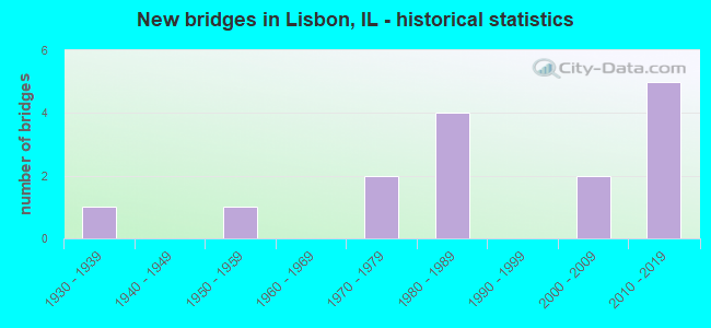
- New bridges - historical statistics
- 11930-1939
- 11950-1959
- 21970-1979
- 41980-1989
- 22000-2009
- 52010-2019


- Bridge Condition - Deck
- 33.3%Very good
- 33.3%Good
- 11.1%Satisfactory
- 11.1%Poor
- 11.1%Serious

- Bridge Condition - Superstructure
- 33.3%Very good
- 33.3%Good
- 11.1%Satisfactory
- 11.1%Poor
- 11.1%Serious

- Bridge Condition - Substructure
- 55.6%Very good
- 22.2%Good
- 22.2%Satisfactory

- Bridge Condition - Channel
- 20.0%Excellent
- 13.3%Very good
- 33.3%Good
- 20.0%Satisfactory
- 6.7%Fair
- 6.7%Poor

- Bridge Condition - Culverts
- 66.7%Very good
- 33.3%Satisfactory
Find on map >> Show street view
Structure Number: 320123, Location: 3.5 MI S/MINOOKA RD (Lat: 41.439533, Lng: -88.423392), Route carried "on" structure: State highway 47, Year Built: 2016, Status: Open, Structure Length: 2.91m (9.55ft), Average Daily Traffic: 5,450 (year 2021), Truck Traffic: 26%, Average Future Daily Traffic: 6,507 (year 2038), Features Intersected: VALLEY RUN Creek
Minimum Vertical Clearance: 30+ m (98+ ft), Kilometerpoint: 150.453, Lanes on structure: 4, Base Highway Network: Yes, Owner: State Highway Agency, Approaching Roadway Width: 24.4m (80.1ft), Skew: 33 degrees, Material/Design: Prestressed concrete, Design/Construction: Stringer/Multi-beam, Number Of Spans In Main Unit: 1, Length of Maximum Span: 27.8m (91.2ft), Curb-To-Curb Width: 24.4m (80.1ft), Out-to-Out Width: 33.9m (111.2ft)
Condition: Deck: Very good, Superstructure: Very good, Substructure: Very good, Channel: Excellent, Operating Rating: 66.4 metric tons, Method Used To Determine Operating Rating: Load and Resistance Factor Rating (LRFR) rating reported by rating factor(RF) method using HL-93 loadings, Inventory Rating: 49.6 metric tons, Method Used To Determine Inventory Rating: Load and Resistance Factor Rating (LRFR) rating reported by rating factor(RF) method using HL-93 loadings, Structural Evaluation: Equal to present desirable criteria, Deck Geometry: Superior to present desirable criteria, Waterway Adequacy: Superior to present desirable criteria, Approach Roadway Alignment: Equal to present desirable criteria, Designated Inspection Frequency: Every 48 months, Inspection Date: Febuary 2019, Deck Structure Type: Concrete Cast-file-Place, Wearing Surface/Protective System: Deck Protection: Epoxy Coated Reinforcing
Find on map >> Show street view
Structure Number: 323001, Location: .46 MILE W IL 47 (Lat: 41.459142, Lng: -88.432589), Route carried "on" structure: County highway , Year Built: 2013, Status: Open, Structure Length: 1.65m (5.41ft), Average Daily Traffic: 150 (year 2019), Truck Traffic: 10%, Average Future Daily Traffic: 171 (year 2032), Design Load: HS 25 or greater, Features Intersected: VALLEY RUN, Facility Carried by Structure: CH 16C(SHERRILL RD
Minimum Vertical Clearance: 30+ m (98+ ft), Kilometerpoint: 4.088, Lanes on structure: 2, Owner: County Highway Agency, Approaching Roadway Width: 6.1m (20.0ft), Material/Design: Prestressed concrete, Design/Construction: Box Beam or Girders - Multiple, Number Of Spans In Main Unit: 1, Length of Maximum Span: 15.5m (50.9ft), Curb-To-Curb Width: 9.1m (29.9ft), Out-to-Out Width: 9.1m (29.9ft)
Condition: Deck: Good, Superstructure: Good, Substructure: Very good, Channel: Good, Operating Rating: 49.2 metric tons, Method Used To Determine Operating Rating: Load and Resistance Factor Rating (LRFR) rating reported by rating factor(RF) method using HL-93 loadings, Inventory Rating: 38.9 metric tons, Method Used To Determine Inventory Rating: Load and Resistance Factor Rating (LRFR) rating reported by rating factor(RF) method using HL-93 loadings, Structural Evaluation: Better than present minimum criteria, Deck Geometry: Equal to present minimum criteria, Waterway Adequacy: Superior to present desirable criteria, Approach Roadway Alignment: Equal to present desirable criteria, Designated Inspection Frequency: Every 48 months, Inspection Date: October 2020, Deck Structure Type: Concrete Precast Panels, Wearing Surface/Protective System: Wearing Surface: Bituminous, Membrane: Built-up
Find on map >> Show street view
Structure Number: 323025, Location: 0.71 MI S SHERRIL RD (Lat: 41.447617, Lng: -88.481492), Route carried "on" structure: County highway , Year Built: 1985, Status: Open, Structure Length: 1.53m (5.02ft), Average Daily Traffic: 1,000 (year 2019), Truck Traffic: 8%, Average Future Daily Traffic: 967 (year 2032), Design Load: HS 20, Features Intersected: SARATOGA CREEK, Facility Carried by Structure: CH 27 LISBON RD
Minimum Vertical Clearance: 30+ m (98+ ft), Kilometerpoint: 1.143, Lanes on structure: 2, Owner: County Highway Agency, Approaching Roadway Width: 9.1m (29.9ft), Material/Design: Prestressed concrete, Design/Construction: Box Beam or Girders - Multiple, Number Of Spans In Main Unit: 1, Length of Maximum Span: 14.6m (47.9ft), Curb-To-Curb Width: 8.9m (29.2ft), Out-to-Out Width: 9.1m (29.9ft)
Condition: Deck: Poor, Superstructure: Poor, Substructure: Very good, Channel: Good, Operating Rating: 38.2 metric tons, Method Used To Determine Operating Rating: Load Factor (LF) rating reported by rating factor (RF) method using MS18 loading, Inventory Rating: 23.0 metric tons, Method Used To Determine Inventory Rating: Load Factor (LF) rating reported by rating factor (RF) method using MS18 loading, Structural Evaluation: Meets minimum limits, Deck Geometry: Somewhat better than minimum adequacy, Waterway Adequacy: Equal to present desirable criteria, Approach Roadway Alignment: Equal to present desirable criteria, Designated Inspection Frequency: Every 24 months, Other Special Inspection Frequency: Every 12 months, Inspection Date: October 2020, Other Special Inspection Date: October 2021, Deck Structure Type: Concrete Precast Panels, Wearing Surface/Protective System: Wearing Surface: Bituminous
Find on map >> Show street view
Structure Number: 323055, Location: 0.65 MI W OF TR 86 (Lat: 41.428761, Lng: -88.493872), Route carried "on" structure: County highway , Year Built: 1980, Status: Open, Structure Length: 1.76m (5.77ft), Average Daily Traffic: 225 (year 2019), Truck Traffic: 9%, Average Future Daily Traffic: 313 (year 2032), Design Load: HS 20, Features Intersected: EAST FORK NETTLE CR, Facility Carried by Structure: TR-7 (Airport Road
Minimum Vertical Clearance: 30+ m (98+ ft), Kilometerpoint: 8.449, Lanes on structure: 2, Owner: Town or Township Highway Agency, Approaching Roadway Width: 7.9m (25.9ft), Skew: 1 degrees, Material/Design: Concrete, Design/Construction: Channel Beam, Number Of Spans In Main Unit: 2, Length of Maximum Span: 8.3m (27.2ft), Curb-To-Curb Width: 7.9m (25.9ft), Out-to-Out Width: 8.0m (26.2ft)
Condition: Deck: Serious, Superstructure: Serious, Substructure: Satisfactory, Channel: Satisfactory, Operating Rating: 60.6 metric tons, Method Used To Determine Operating Rating: Load Factor (LF) rating reported by rating factor (RF) method using MS18 loading, Inventory Rating: 25.3 metric tons, Method Used To Determine Inventory Rating: Load Factor (LF) rating reported by rating factor (RF) method using MS18 loading, Structural Evaluation: High priority of corrective action, Deck Geometry: Somewhat better than minimum adequacy, Waterway Adequacy: Better than present minimum criteria, Approach Roadway Alignment: Equal to present desirable criteria, Designated Inspection Frequency: Every 24 months, Inspection Date: October 2020, Deck Structure Type: Concrete Precast Panels
Find on map >> Show street view
Structure Number: 323611, Location: .09 MI W SCOTT SC RD (Lat: 41.443339, Lng: -88.512164), Route carried "on" structure: County highway , Year Built: 1984, Status: Open, Structure Length: 0.98m (3.22ft), Average Daily Traffic: 375 (year 2019), Truck Traffic: 14%, Average Future Daily Traffic: 313 (year 2032), Design Load: HS 20, Features Intersected: EAST FK NETTLE CREEK, Facility Carried by Structure: TR 3 MINOOKA RD
Minimum Vertical Clearance: 30+ m (98+ ft), Kilometerpoint: 6.968, Lanes on structure: 2, Owner: Town or Township Highway Agency, Approaching Roadway Width: 7.9m (25.9ft), Skew: 3 degrees, Material/Design: Concrete, Design/Construction: Channel Beam, Number Of Spans In Main Unit: 1, Length of Maximum Span: 9.1m (29.9ft), Curb-To-Curb Width: 7.8m (25.6ft), Out-to-Out Width: 8.0m (26.2ft)
Condition: Deck: Very good, Superstructure: Very good, Substructure: Very good, Channel: Good, Operating Rating: 53.8 metric tons, Method Used To Determine Operating Rating: Load Factor (LF) rating reported by rating factor (RF) method using MS18 loading, Inventory Rating: 32.4 metric tons, Method Used To Determine Inventory Rating: Load Factor (LF) rating reported by rating factor (RF) method using MS18 loading, Structural Evaluation: Equal to present desirable criteria, Deck Geometry: Somewhat better than minimum adequacy, Waterway Adequacy: Equal to present desirable criteria, Approach Roadway Alignment: Equal to present desirable criteria, Designated Inspection Frequency: Every 48 months, Inspection Date: October 2018, Deck Structure Type: Concrete Precast Panels, Wearing Surface/Protective System: Wearing Surface: Bituminous
Find on map >> Show street view
Structure Number: 323756, Location: 0.36 MI E LISBON RD (Lat: 41.443681, Lng: -88.474428), Route carried "on" structure: County highway , Year Built: 1984, Status: Open, Structure Length: 0.82m (2.69ft), Average Daily Traffic: 300 (year 2019), Truck Traffic: 9%, Average Future Daily Traffic: 142 (year 2032), Design Load: HS 20, Features Intersected: SARATOGA CREEK, Facility Carried by Structure: TR 3B MINOOKA ROAD
Minimum Vertical Clearance: 30+ m (98+ ft), Kilometerpoint: 0.579, Lanes on structure: 2, Owner: Town or Township Highway Agency, Approaching Roadway Width: 7.3m (24.0ft), Skew: 3 degrees, Material/Design: Steel, Design/Construction: Culvert, Number Of Spans In Main Unit: 3, Length of Maximum Span: 2.1m (6.9ft), Curb-To-Curb Width: 7.3m (24.0ft), Out-to-Out Width: 7.3m (24.0ft)
Condition: Channel: Poor, Culverts: Satisfactory, Operating Rating: 29.2 metric tons, Method Used To Determine Operating Rating: Load Factor (LF) rating reported by rating factor (RF) method using MS18 loading, Inventory Rating: 17.5 metric tons, Method Used To Determine Inventory Rating: Load Factor (LF) rating reported by rating factor (RF) method using MS18 loading, Structural Evaluation: Somewhat better than minimum adequacy, Deck Geometry: Somewhat better than minimum adequacy, Waterway Adequacy: Somewhat better than minimum adequacy, Approach Roadway Alignment: Equal to present desirable criteria, Designated Inspection Frequency: Every 24 months, Inspection Date: October 2020, Deck Structure Type: Concrete Cast-file-Place
Find on map >> Show street view
Structure Number: 32376, Location: .71 MI W MIDDLE RD (Lat: 41.444061, Lng: -88.456497), Route carried "on" structure: County highway , Year Built: 1975, Status: Open, Structure Length: 1.04m (3.41ft), Average Daily Traffic: 300 (year 2019), Truck Traffic: 9%, Average Future Daily Traffic: 142 (year 2032), Design Load: HS 15, Features Intersected: SARATOGA CREEK, Facility Carried by Structure: MINOOKA RD TR-3B
Minimum Vertical Clearance: 30+ m (98+ ft), Kilometerpoint: 2.076, Lanes on structure: 2, Owner: Town or Township Highway Agency, Approaching Roadway Width: 7.3m (24.0ft), Skew: 1 degrees, Material/Design: Concrete, Design/Construction: Channel Beam, Number Of Spans In Main Unit: 1, Length of Maximum Span: 9.8m (32.2ft), Curb-To-Curb Width: 7.4m (24.3ft), Out-to-Out Width: 8.0m (26.2ft)
Condition: Deck: Good, Superstructure: Good, Substructure: Good, Channel: Satisfactory, Operating Rating: 51.2 metric tons, Method Used To Determine Operating Rating: Load Factor (LF) rating reported by rating factor (RF) method using MS18 loading, Inventory Rating: 30.8 metric tons, Method Used To Determine Inventory Rating: Load Factor (LF) rating reported by rating factor (RF) method using MS18 loading, Structural Evaluation: Better than present minimum criteria, Deck Geometry: Somewhat better than minimum adequacy, Waterway Adequacy: Meets minimum limits, Approach Roadway Alignment: Equal to present desirable criteria, Designated Inspection Frequency: Every 48 months, Inspection Date: October 2020, Deck Structure Type: Concrete Precast Panels, Wearing Surface/Protective System: Wearing Surface: Bituminous
Find on map >> Show street view
Structure Number: 323766, Location: 0.13 MI W ILL RT 47 (Lat: 41.444783, Lng: -88.425983), Route carried "on" structure: County highway , Year Built: 2009, Status: Open, Structure Length: 1.63m (5.35ft), Average Daily Traffic: 300 (year 2019), Truck Traffic: 9%, Average Future Daily Traffic: 142 (year 2032), Design Load: HS 25 or greater, Features Intersected: VALLEY RUN, Facility Carried by Structure: TR-3B MINOOKA RD
Minimum Vertical Clearance: 30+ m (98+ ft), Kilometerpoint: 4.619, Lanes on structure: 2, Owner: Town or Township Highway Agency, Approaching Roadway Width: 6.1m (20.0ft), Material/Design: Prestressed concrete, Design/Construction: Box Beam or Girders - Multiple, Number Of Spans In Main Unit: 10, Length of Maximum Span: 16.3m (53.5ft), Curb-To-Curb Width: 9.1m (29.9ft), Out-to-Out Width: 9.1m (29.9ft)
Condition: Deck: Very good, Superstructure: Very good, Substructure: Very good, Channel: Excellent, Operating Rating: 44.1 metric tons, Method Used To Determine Operating Rating: Assigned rating based on Load Factor Design (LFD) reported by rating factor (RF) using MS18 loading, Inventory Rating: 32.4 metric tons, Method Used To Determine Inventory Rating: Assigned rating based on Load Factor Design (LFD) reported by rating factor (RF) using MS18 loading, Structural Evaluation: Equal to present desirable criteria, Deck Geometry: Equal to present minimum criteria, Waterway Adequacy: Superior to present desirable criteria, Approach Roadway Alignment: Equal to present desirable criteria, Designated Inspection Frequency: Every 48 months, Inspection Date: October 2020, Deck Structure Type: Concrete Precast Panels, Wearing Surface/Protective System: Wearing Surface: Bituminous, Membrane: Built-up
Find on map >> Show street view
Structure Number: 470014, Location: 1.09 MI W ILL 47 (Lat: 41.507522, Lng: -88.454419), Route carried "on" structure: US 52, Year Built: 1936, Year Reconstructed: 1986, Status: Open, Structure Length: 0.91m (2.99ft), Average Daily Traffic: 1,250 (year 2021), Truck Traffic: 18%, Average Future Daily Traffic: 2,190 (year 2032), Design Load: HS 20, Features Intersected: LISBON CREEK
Minimum Vertical Clearance: 30+ m (98+ ft), Kilometerpoint: 194.307, Lanes on structure: 2, Base Highway Network: Yes, Owner: State Highway Agency, Approaching Roadway Width: 7.3m (24.0ft), Skew: 3 degrees, Material/Design: Concrete, Design/Construction: Slab, Number Of Spans In Main Unit: 1, Length of Maximum Span: 8.5m (27.9ft), Curb-To-Curb Width: 12.2m (40.0ft), Out-to-Out Width: 12.2m (40.0ft)
Condition: Deck: Satisfactory, Superstructure: Satisfactory, Substructure: Satisfactory, Channel: Good, Operating Rating: 63.2 metric tons, Method Used To Determine Operating Rating: Load Factor (LF) rating reported by rating factor (RF) method using MS18 loading, Inventory Rating: 37.9 metric tons, Method Used To Determine Inventory Rating: Load Factor (LF) rating reported by rating factor (RF) method using MS18 loading, Structural Evaluation: Equal to present minimum criteria, Deck Geometry: Better than present minimum criteria, Waterway Adequacy: Equal to present desirable criteria, Approach Roadway Alignment: Equal to present desirable criteria, Designated Inspection Frequency: Every 24 months, Inspection Date: December 2020, Deck Structure Type: Concrete Cast-file-Place, Wearing Surface/Protective System: Deck Protection: Epoxy Coated Reinforcing
Find on map >> Show street view
Structure Number: 472018, Location: 0.05 MI E OF ILL 47 (Lat: 41.509975, Lng: -88.432947), Route carried "on" structure: US 52, Year Built: 2001, Status: Open, Structure Length: 0.73m (2.40ft), Average Daily Traffic: 4,050 (year 2021), Truck Traffic: 23%, Average Future Daily Traffic: 4,672 (year 2032), Design Load: HS 20, Features Intersected: LISBON CREEK
Minimum Vertical Clearance: 30+ m (98+ ft), Kilometerpoint: 196.141, Lanes on structure: 2, Base Highway Network: Yes, Owner: State Highway Agency, Approaching Roadway Width: 16.8m (55.1ft), Skew: 11 degrees, Material/Design: Concrete, Design/Construction: Culvert, Number Of Spans In Main Unit: 2, Length of Maximum Span: 3.1m (10.2ft)
Condition: Channel: Good, Culverts: Very good, Operating Rating: 44.1 metric tons, Method Used To Determine Operating Rating: Load Factor (LF) rating reported by rating factor (RF) method using MS18 loading, Inventory Rating: 32.4 metric tons, Method Used To Determine Inventory Rating: Load Factor (LF) rating reported by rating factor (RF) method using MS18 loading, Structural Evaluation: Equal to present desirable criteria, Waterway Adequacy: Equal to present desirable criteria, Approach Roadway Alignment: Equal to present desirable criteria, Designated Inspection Frequency: Every 48 months, Inspection Date: January 2019
Find on map >> Show street view
Structure Number: 47203, Location: 0.05 M N of US 52 (Lat: 41.510667, Lng: -88.433886), Route carried "on" structure: State highway 47, Year Built: 2018, Status: Open, Structure Length: 0.72m (2.36ft), Average Daily Traffic: 7,400 (year 2021), Truck Traffic: 25%, Average Future Daily Traffic: 11,501 (year 2038), Design Load: HS 25 or greater, Features Intersected: Drainage Ditch
Minimum Vertical Clearance: 30+ m (98+ ft), Kilometerpoint: 158.645, Lanes on structure: 4, Base Highway Network: Yes, Owner: State Highway Agency, Approaching Roadway Width: 21.9m (71.9ft), Skew: 30 degrees, Material/Design: Concrete, Design/Construction: Culvert, Number Of Spans In Main Unit: 2, Length of Maximum Span: 3.3m (10.8ft), Curb-To-Curb Width: 29.9m (98.1ft), Out-to-Out Width: 47.5m (155.8ft)
Condition: Channel: Very good, Culverts: Very good, Operating Rating: 51.2 metric tons, Method Used To Determine Operating Rating: Load and Resistance Factor Rating (LRFR) rating reported by rating factor(RF) method using HL-93 loadings, Inventory Rating: 39.5 metric tons, Method Used To Determine Inventory Rating: Load and Resistance Factor Rating (LRFR) rating reported by rating factor(RF) method using HL-93 loadings, Structural Evaluation: Equal to present desirable criteria, Deck Geometry: Superior to present desirable criteria, Waterway Adequacy: Equal to present desirable criteria, Approach Roadway Alignment: Equal to present desirable criteria, Designated Inspection Frequency: Every 48 months, Inspection Date: August 2021
Find on map >> Show street view
Structure Number: 472033, Location: 0.66 M S of US 52 (Lat: 41.500272, Lng: -88.434019), Route carried "on" structure: State highway 47, Year Built: 2018, Status: Open, Structure Length: 0.80m (2.62ft), Average Daily Traffic: 4,800 (year 2021), Truck Traffic: 24%, Average Future Daily Traffic: 8,041 (year 2038), Design Load: HS 25 or greater, Features Intersected: West Aux Sable Creek
Minimum Vertical Clearance: 30+ m (98+ ft), Kilometerpoint: 157.502, Lanes on structure: 4, Base Highway Network: Yes, Owner: State Highway Agency, Approaching Roadway Width: 21.9m (71.9ft), Skew: 11 degrees, Material/Design: Concrete, Design/Construction: Culvert, Number Of Spans In Main Unit: 2, Length of Maximum Span: 3.7m (12.1ft), Curb-To-Curb Width: 21.9m (71.9ft), Out-to-Out Width: 44.0m (144.4ft)
Condition: Channel: Very good, Culverts: Very good, Operating Rating: 59.0 metric tons, Method Used To Determine Operating Rating: Load and Resistance Factor Rating (LRFR) rating reported by rating factor(RF) method using HL-93 loadings, Inventory Rating: 45.4 metric tons, Method Used To Determine Inventory Rating: Load and Resistance Factor Rating (LRFR) rating reported by rating factor(RF) method using HL-93 loadings, Structural Evaluation: Equal to present desirable criteria, Deck Geometry: Superior to present desirable criteria, Waterway Adequacy: Equal to present desirable criteria, Approach Roadway Alignment: Equal to present desirable criteria, Designated Inspection Frequency: Every 48 months, Inspection Date: August 2021
Find on map >> Show street view
Structure Number: 472052, Location: 4.8 MI W OF ILL 47 (Lat: 41.487239, Lng: -88.508450), Route carried "on" structure: US 52, Year Built: 2017, Status: Open, Structure Length: 0.72m (2.36ft), Average Daily Traffic: 1,250 (year 2021), Truck Traffic: 46%, Average Future Daily Traffic: 2,618 (year 2038), Design Load: HS 25 or greater, Features Intersected: SARATOGA CR
Minimum Vertical Clearance: 30+ m (98+ ft), Kilometerpoint: 188.272, Lanes on structure: 2, Base Highway Network: Yes, Owner: State Highway Agency, Approaching Roadway Width: 7.3m (24.0ft), Material/Design: Concrete, Design/Construction: Culvert, Number Of Spans In Main Unit: 2, Length of Maximum Span: 3.3m (10.8ft), Curb-To-Curb Width: 9.8m (32.2ft), Out-to-Out Width: 13.4m (44.0ft)
Condition: Channel: Excellent, Culverts: Very good, Operating Rating: 50.2 metric tons, Method Used To Determine Operating Rating: Load and Resistance Factor Rating (LRFR) rating reported by rating factor(RF) method using HL-93 loadings, Inventory Rating: 38.9 metric tons, Method Used To Determine Inventory Rating: Load and Resistance Factor Rating (LRFR) rating reported by rating factor(RF) method using HL-93 loadings, Structural Evaluation: Equal to present desirable criteria, Deck Geometry: Somewhat better than minimum adequacy, Waterway Adequacy: Superior to present desirable criteria, Approach Roadway Alignment: Equal to present desirable criteria, Designated Inspection Frequency: Every 48 months, Inspection Date: January 2019, Deck Structure Type: Other
Find on map >> Show street view
Structure Number: 473008, Location: CH19 OVR VALLEY RUN (Lat: 41.480108, Lng: -88.449328), Route carried "on" structure: County highway , Year Built: 1958, Status: Open, Structure Length: 0.91m (2.99ft), Average Daily Traffic: 500 (year 2019), Truck Traffic: 5%, Average Future Daily Traffic: 803 (year 2032), Design Load: HS 15, Features Intersected: VALLEY RUN CREEK, Facility Carried by Structure: JOLIET ROAD
Minimum Vertical Clearance: 30+ m (98+ ft), Kilometerpoint: 4.232, Lanes on structure: 2, Owner: County Highway Agency, Approaching Roadway Width: 9.8m (32.2ft), Material/Design: Concrete, Design/Construction: Slab, Number Of Spans In Main Unit: 1, Length of Maximum Span: 8.5m (27.9ft), Curb-To-Curb Width: 11.0m (36.1ft), Out-to-Out Width: 11.0m (36.1ft)
Condition: Deck: Good, Superstructure: Good, Substructure: Good, Channel: Fair, Operating Rating: 60.3 metric tons, Method Used To Determine Operating Rating: Load Factor (LF) rating reported by rating factor (RF) method using MS18 loading, Inventory Rating: 36.3 metric tons, Method Used To Determine Inventory Rating: Load Factor (LF) rating reported by rating factor (RF) method using MS18 loading, Structural Evaluation: Better than present minimum criteria, Deck Geometry: Better than present minimum criteria, Waterway Adequacy: Equal to present minimum criteria, Approach Roadway Alignment: Better than present minimum criteria, Designated Inspection Frequency: Every 24 months, Inspection Date: December 2021, Deck Structure Type: Concrete Cast-file-Place
Find on map >> Show street view
Structure Number: 473075, Location: 1.2 Mi W of 47 (Lat: 41.472750, Lng: -88.470569), Route carried "on" structure: County highway , Year Built: 1970, Status: Open, Structure Length: 0.73m (2.40ft), Average Daily Traffic: 150 (year 2019), Truck Traffic: 14%, Average Future Daily Traffic: 219 (year 2030), Features Intersected: Valley Run Creek, Facility Carried by Structure: Whitewillow Road
Minimum Vertical Clearance: 30+ m (98+ ft), Kilometerpoint: 0.869, Lanes on structure: 2, Owner: Town or Township Highway Agency, Approaching Roadway Width: 7.3m (24.0ft), Skew: 9 degrees, Material/Design: Steel, Design/Construction: Culvert, Number Of Spans In Main Unit: 2, Length of Maximum Span: 0.0m
Condition: Channel: Satisfactory, Culverts: Satisfactory, Operating Rating: 32.4 metric tons, Method Used To Determine Operating Rating: Field evaluation and documented engineering judgment, Inventory Rating: 24.3 metric tons, Method Used To Determine Inventory Rating: Field evaluation and documented engineering judgment, Structural Evaluation: Equal to present minimum criteria, Waterway Adequacy: Equal to present minimum criteria, Approach Roadway Alignment: Better than present minimum criteria, Designated Inspection Frequency: Every 24 months, Inspection Date: December 2021