Bridge Statistics for Linwood, New Jersey (NJ)
Condition, Traffic, Stress, Structural Evaluation, Project Costs
- National Bridge Inventory (NBI) Statistics
- 13Number of bridges
- 469ft / 143mTotal length
- $1,433,000Total costs
- 131,148Total average daily traffic
- 5,443Total average daily truck traffic
- National Bridge Inventory (NBI) Registered Bridges for Linwood
- No street view available for this location
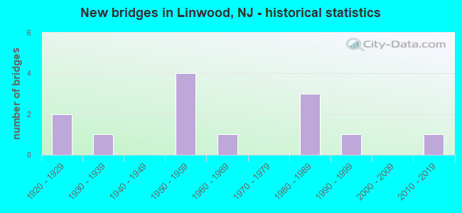
- New bridges - historical statistics
- 21920-1929
- 11930-1939
- 41950-1959
- 11960-1969
- 31980-1989
- 11990-1999
- 12010-2019
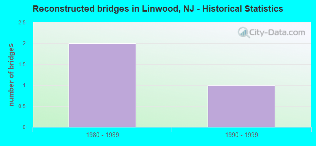
- Reconstructed bridges - Historical Statistics
- 21980-1989
- 11990-1999
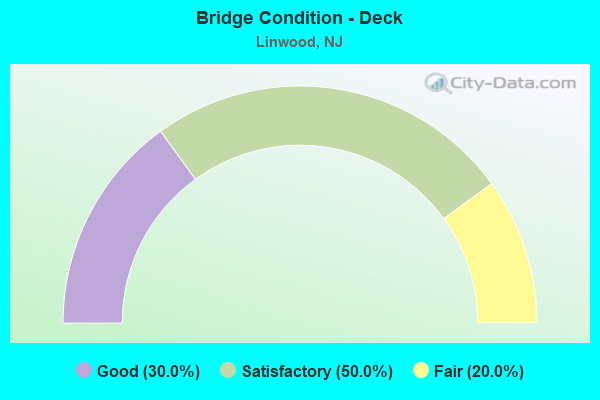
- Bridge Condition - Deck
- 30.0%Good
- 50.0%Satisfactory
- 20.0%Fair
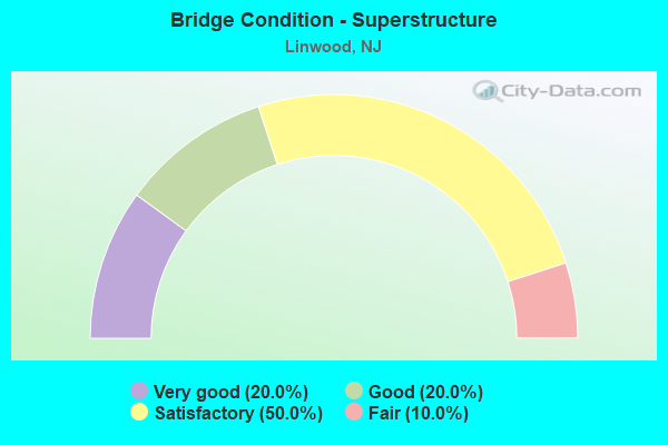
- Bridge Condition - Superstructure
- 20.0%Very good
- 20.0%Good
- 50.0%Satisfactory
- 10.0%Fair
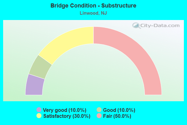
- Bridge Condition - Substructure
- 10.0%Very good
- 10.0%Good
- 30.0%Satisfactory
- 50.0%Fair
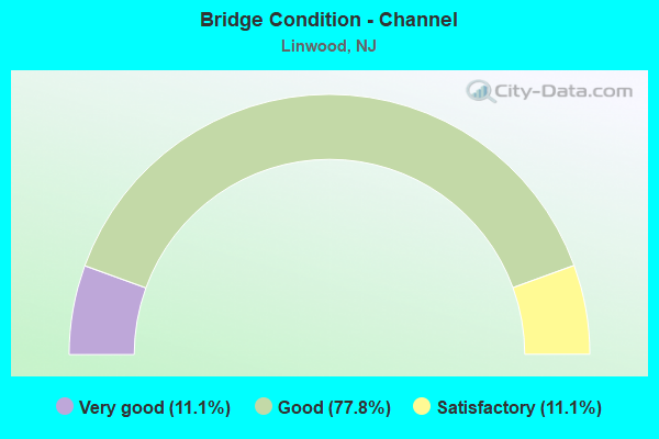
- Bridge Condition - Channel
- 11.1%Very good
- 77.8%Good
- 11.1%Satisfactory
Find on map >> Show street view
Structure Number: 122155, Location: 0.83 MI W OF 152 & 619 JC (Lat: 39.314000, Lng: -74.564350), Route carried "on" structure: State highway 152, Year Built: 1988, Status: Open, Structure Length: 87.26m (286.29ft), Average Daily Traffic: 13,850 (year 2021), Truck Traffic: 7%, Average Future Daily Traffic: 16,620 (year 2041), Design Load: HS 20+Mod, Features Intersected: BROAD THOROFARE
Minimum Vertical Clearance: 30+ m (98+ ft), Kilometerpoint: 2.157, Lanes on structure: 2, Base Highway Network: Yes, Owner: State Highway Agency, Approaching Roadway Width: 15.2m (49.9ft), Skew: 9 degrees, Navigation Control: Yes ( Vertical Clearance: 16.8m (55.1ft), Horizontal Clearance: 42.7m (140.1ft)), Material/Design: Steel continuous, Design/Construction: Stringer/Multi-beam, Number Of Spans In Main Unit: 1, Number Of Approach Spans: 24, Length of Maximum Span: 57.9m (190.0ft), Curb or Sidewalk Widths: Left: 0.0m, Right: 1.8m (5.9ft), Curb-To-Curb Width: 15.2m (49.9ft), Out-to-Out Width: 17.9m (58.7ft)
Condition: Deck: Good, Superstructure: Good, Substructure: Good, Channel: Good, Operating Rating: 87.1 metric tons, Method Used To Determine Operating Rating: Load Factor (LF), Inventory Rating: 52.6 metric tons, Method Used To Determine Inventory Rating: Load Factor (LF), Structural Evaluation: Better than present minimum criteria, Deck Geometry: Superior to present desirable criteria, Waterway Adequacy: Equal to present desirable criteria, Approach Roadway Alignment: Equal to present minimum criteria, Designated Inspection Frequency: Every 24 months, Underwater Inspection Frequency: Every 48 months, Inspection Date: June 2021, Underwater Inspection Date: July 2021, Deck Structure Type: Concrete Cast-file-Place, Wearing Surface/Protective System: Wearing Surface: Monolithic Concrete, Deck Protection: Epoxy Coated Reinforcing
Find on map >> Show street view
Structure Number: 122156, Location: 0.48 MI W OF BROAD THORO- (Lat: 39.314081, Lng: -74.568489), Route carried "on" structure: State highway 152, Year Built: 1988, Status: Open, Structure Length: 1.77m (5.81ft), Average Daily Traffic: 10,955 (year 2021), Truck Traffic: 7%, Average Future Daily Traffic: 13,145 (year 2041), Design Load: HS 20+Mod, Features Intersected: CREEK AT STATION # 91
Minimum Vertical Clearance: 30+ m (98+ ft), Kilometerpoint: 1.819, Lanes on structure: 2, Base Highway Network: Yes, Owner: State Highway Agency, Approaching Roadway Width: 15.2m (49.9ft), Material/Design: Prestressed concrete, Design/Construction: Slab, Number Of Spans In Main Unit: 2, Length of Maximum Span: 8.5m (27.9ft), Curb or Sidewalk Widths: Left: 0.0m, Right: 1.8m (5.9ft), Curb-To-Curb Width: 15.2m (49.9ft), Out-to-Out Width: 17.9m (58.7ft)
Condition: Deck: Satisfactory, Superstructure: Very good, Substructure: Fair, Channel: Very good, Operating Rating: 54.4 metric tons, Method Used To Determine Operating Rating: Field evaluation and documented engineering judgment, Inventory Rating: 32.7 metric tons, Method Used To Determine Inventory Rating: Field evaluation and documented engineering judgment, Structural Evaluation: Somewhat better than minimum adequacy, Deck Geometry: Superior to present desirable criteria, Waterway Adequacy: Equal to present minimum criteria, Approach Roadway Alignment: Equal to present desirable criteria, Designated Inspection Frequency: Every 24 months, Inspection Date: March 2021, Deck Structure Type: Concrete Cast-file-Place, Wearing Surface/Protective System: Deck Protection: Epoxy Coated Reinforcing
Find on map >> Show street view
Structure Number: 1EH01, Location: 0.2MI E. GSPKWY&1MI W RT9 (Lat: 39.368200, Lng: -74.580139), Route carried "on" structure: County highway 615, Year Built: 2015, Status: Open, Structure Length: 0.94m (3.08ft), Average Daily Traffic: 3,800 (year 2021), Truck Traffic: 4%, Average Future Daily Traffic: 4,560 (year 2041), Design Load: HL 93, Features Intersected: PATCONG CREEK
Minimum Vertical Clearance: 30+ m (98+ ft), Kilometerpoint: 9.946, Lanes on structure: 2, Owner: County Highway Agency, Approaching Roadway Width: 9.8m (32.2ft), Material/Design: Prestressed concrete, Design/Construction: Box Beam or Girders - Multiple, Number Of Spans In Main Unit: 1, Length of Maximum Span: 7.9m (25.9ft), Curb-To-Curb Width: 9.8m (32.2ft), Out-to-Out Width: 11.0m (36.1ft)
Condition: Deck: Good, Superstructure: Very good, Substructure: Very good, Channel: Good, Operating Rating: 85.9 metric tons, Method Used To Determine Operating Rating: Load and Resistance Factor Rating (LRFR) rating reported by rating factor(RF) method using HL-93 loadings, Inventory Rating: 66.1 metric tons, Method Used To Determine Inventory Rating: Load and Resistance Factor Rating (LRFR) rating reported by rating factor(RF) method using HL-93 loadings, Structural Evaluation: Equal to present desirable criteria, Deck Geometry: Meets minimum limits, Waterway Adequacy: Equal to present minimum criteria, Approach Roadway Alignment: Better than present minimum criteria, Designated Inspection Frequency: Every 24 months, Underwater Inspection Frequency: Every 24 months, Inspection Date: August 2021, Underwater Inspection Date: August 2021, Deck Structure Type: Concrete Cast-file-Place, Wearing Surface/Protective System: Wearing Surface: Monolithic Concrete
Find on map >> Show street view
Structure Number: 1EH011, Location: 0.2 mile East CR 651 (Lat: 39.361061, Lng: -74.577089), Route carried "on" structure: City street , Year Built: 1930, Year Reconstructed: 1998, Status: Open, Structure Length: 0.94m (3.08ft), Average Daily Traffic: 4,056 (year 2021), Truck Traffic: 3%, Average Future Daily Traffic: 4,867 (year 2041), Design Load: HS 20, Features Intersected: PATCONG CREEK, Facility Carried by Structure: CENTRAL AVE
Minimum Vertical Clearance: 30+ m (98+ ft), Kilometerpoint: 0.000, Lanes on structure: 2, Owner: County Highway Agency, Approaching Roadway Width: 9.1m (29.9ft), Material/Design: Steel, Design/Construction: Stringer/Multi-beam, Number Of Spans In Main Unit: 1, Length of Maximum Span: 7.9m (25.9ft), Curb or Sidewalk Widths: Left: 1.7m (5.6ft), Right: 0.0m, Curb-To-Curb Width: 9.1m (29.9ft), Out-to-Out Width: 12.0m (39.4ft)
Condition: Deck: Fair, Superstructure: Satisfactory, Substructure: Fair, Channel: Good, Operating Rating: 53.5 metric tons, Method Used To Determine Operating Rating: Load Factor (LF), Inventory Rating: 31.8 metric tons, Method Used To Determine Inventory Rating: Load Factor (LF), Structural Evaluation: Somewhat better than minimum adequacy, Deck Geometry: Meets minimum limits, Waterway Adequacy: Equal to present minimum criteria, Approach Roadway Alignment: Equal to present desirable criteria, Length Of Structure Improvement: 0.91m (2.99ft), Designated Inspection Frequency: Every 24 months, Inspection Date: January 2021, Bridge Improvement Cost: $127,000, Roadway Improvement Cost: $61,000, Total Project Cost: $387,000 ( Estimate for 2017), Deck Structure Type: Concrete Cast-file-Place, Wearing Surface/Protective System: Wearing Surface: Bituminous
Find on map >> Show street view
Structure Number: 1EH013, Location: 0.24 MI W of Rt 9 (Lat: 39.355269, Lng: -74.579389), Route carried "on" structure: City street , Year Built: 1987, Status: Open, Structure Length: 2.29m (7.51ft), Average Daily Traffic: 1,709 (year 2021), Truck Traffic: 3%, Average Future Daily Traffic: 2,051 (year 2041), Design Load: HS 20+Mod, Features Intersected: PATCONG CREEK, Facility Carried by Structure: POPLAR AVENUE
Minimum Vertical Clearance: 30+ m (98+ ft), Kilometerpoint: 0.435, Lanes on structure: 2, Owner: County Highway Agency, Approaching Roadway Width: 9.1m (29.9ft), Skew: 3 degrees, Material/Design: Prestressed concrete, Design/Construction: Box Beam or Girders - Multiple, Number Of Spans In Main Unit: 2, Length of Maximum Span: 10.7m (35.1ft), Curb or Sidewalk Widths: Left: 1.8m (5.9ft), Right: 1.8m (5.9ft), Curb-To-Curb Width: 9.2m (30.2ft), Out-to-Out Width: 13.5m (44.3ft)
Condition: Deck: Satisfactory, Superstructure: Good, Substructure: Satisfactory, Channel: Good, Operating Rating: 59.0 metric tons, Method Used To Determine Operating Rating: Load and Resistance Factor Rating (LRFR) rating reported by rating factor(RF) method using HL-93 loadings, Inventory Rating: 45.7 metric tons, Method Used To Determine Inventory Rating: Load and Resistance Factor Rating (LRFR) rating reported by rating factor(RF) method using HL-93 loadings, Structural Evaluation: Equal to present minimum criteria, Deck Geometry: Somewhat better than minimum adequacy, Waterway Adequacy: Equal to present desirable criteria, Approach Roadway Alignment: Equal to present desirable criteria, Designated Inspection Frequency: Every 24 months, Underwater Inspection Frequency: Every 48 months, Inspection Date: January 2021, Underwater Inspection Date: April 2019, Deck Structure Type: Concrete Cast-file-Place, Wearing Surface/Protective System: Wearing Surface: Monolithic Concrete, Deck Protection: Epoxy Coated Reinforcing
Find on map >> Show street view
Structure Number: 1EH014, Location: 0.59 MI N. of 559ALT (Lat: 39.345950, Lng: -74.592289), Route carried "on" structure: City street , Year Built: 1990, Status: Open, Structure Length: 0.67m (2.20ft), Average Daily Traffic: 4,000 (year 2021), Truck Traffic: 3%, Average Future Daily Traffic: 4,801 (year 2041), Design Load: HS 20+Mod, Features Intersected: TRIB. TO PATCONG CREEK, Facility Carried by Structure: BLACKMAN ROAD
Minimum Vertical Clearance: 30+ m (98+ ft), Kilometerpoint: 0.950, Lanes on structure: 2, Owner: County Highway Agency, Approaching Roadway Width: 9.1m (29.9ft), Material/Design: Concrete, Design/Construction: Culvert, Number Of Spans In Main Unit: 2, Length of Maximum Span: 3.0m (9.8ft), Curb-To-Curb Width: 9.3m (30.5ft), Out-to-Out Width: 12.8m (42.0ft)
Condition: Channel: Satisfactory, Culverts: Satisfactory, Operating Rating: 89.8 metric tons, Method Used To Determine Operating Rating: Load Factor (LF), Inventory Rating: 68.9 metric tons, Method Used To Determine Inventory Rating: Load Factor (LF), Structural Evaluation: Equal to present minimum criteria, Deck Geometry: Meets minimum limits, Waterway Adequacy: Equal to present desirable criteria, Approach Roadway Alignment: Equal to present desirable criteria, Designated Inspection Frequency: Every 24 months, Inspection Date: January 2021
Find on map >> Show street view
Structure Number: 1EH033, Location: 0.37 mi North Rt 9 (Lat: 39.335861, Lng: -74.595831), Route carried "on" structure: Alternate County highway 559, Year Built: 1968, Status: Open, Structure Length: 8.53m (27.99ft), Average Daily Traffic: 18,953 (year 2021), Truck Traffic: 4%, Average Future Daily Traffic: 22,743 (year 2041), Design Load: HS 20, Features Intersected: PATCONG CREEK, Facility Carried by Structure: OCEAN HEIGHTS AVE
Minimum Vertical Clearance: 30+ m (98+ ft), Kilometerpoint: 1.336, Lanes on structure: 2, Owner: County Highway Agency, Approaching Roadway Width: 7.6m (24.9ft), Skew: 3 degrees, Navigation Control: Yes ( Vertical Clearance: 2.1m (6.9ft), Horizontal Clearance: 15.2m (49.9ft)), Material/Design: Prestressed concrete, Design/Construction: Stringer/Multi-beam, Number Of Spans In Main Unit: 5, Length of Maximum Span: 16.5m (54.1ft), Curb or Sidewalk Widths: Left: 0.2m (0.7ft), Right: 0.6m (2.0ft), Curb-To-Curb Width: 7.7m (25.3ft), Out-to-Out Width: 9.2m (30.2ft)
Condition: Deck: Satisfactory, Superstructure: Satisfactory, Substructure: Fair, Channel: Good, Operating Rating: 63.5 metric tons, Method Used To Determine Operating Rating: Load Factor (LF), Inventory Rating: 38.1 metric tons, Method Used To Determine Inventory Rating: Load Factor (LF), Structural Evaluation: Somewhat better than minimum adequacy, Deck Geometry: High priority of replacement, Waterway Adequacy: Equal to present desirable criteria, Approach Roadway Alignment: Equal to present minimum criteria, Length Of Structure Improvement: 8.53m (27.99ft), Designated Inspection Frequency: Every 24 months, Underwater Inspection Frequency: Every 48 months, Inspection Date: January 2021, Underwater Inspection Date: April 2021, Bridge Improvement Cost: $727,000, Roadway Improvement Cost: $73,000, Total Project Cost: $1,046,000 ( Estimate for 2021), Deck Structure Type: Concrete Cast-file-Place, Wearing Surface/Protective System: Wearing Surface: Bituminous
Find on map >> Show street view
Structure Number: 360320N, Location: 2.75 MI N OF RT 52 CIRCLE (Lat: 39.348822, Lng: -74.598308), Route carried "on" structure: Other road GSP, Year Built: 1954, Status: Open, Structure Length: 2.53m (8.30ft), Average Daily Traffic: 21,942 (year 2021), Truck Traffic: 3%, Average Future Daily Traffic: 26,774 (year 2041), Design Load: HS 20, Features Intersected: STEELMANVILLE RD-CR 651
Minimum Vertical Clearance: 30+ m (98+ ft), Kilometerpoint: 51.531, Lanes on structure: 2, Lanes under structure: 2, Base Highway Network: Yes, Toll: On toll road, Owner: State Toll Authority, Approaching Roadway Width: 12.2m (40.0ft), Skew: 4 degrees, Material/Design: Steel, Design/Construction: Stringer/Multi-beam, Number Of Spans In Main Unit: 1, Length of Maximum Span: 21.6m (70.9ft), Curb-To-Curb Width: 12.3m (40.4ft), Out-to-Out Width: 13.4m (44.0ft)
Condition: Deck: Good, Superstructure: Satisfactory, Substructure: Satisfactory, Operating Rating: 59.3 metric tons, Method Used To Determine Operating Rating: Load and Resistance Factor Rating (LRFR) rating reported by rating factor(RF) method using HL-93 loadings, Inventory Rating: 45.4 metric tons, Method Used To Determine Inventory Rating: Load and Resistance Factor Rating (LRFR) rating reported by rating factor(RF) method using HL-93 loadings, Structural Evaluation: Equal to present minimum criteria, Deck Geometry: Better than present minimum criteria, Underclear: Meets minimum limits, Approach Roadway Alignment: Equal to present desirable criteria, Designated Inspection Frequency: Every 24 months, Inspection Date: April 2021, Deck Structure Type: Concrete Cast-file-Place, Wearing Surface/Protective System: Wearing Surface: Bituminous, Membrane: Preformed Fabric
Find on map >> Show street view
Structure Number: 360320S, Location: 2.75 MI N OF RT 52 CIRCLE (Lat: 39.348492, Lng: -74.599044), Route carried "on" structure: Other road GSP, Year Built: 1954, Status: Open, Structure Length: 2.53m (8.30ft), Average Daily Traffic: 22,677 (year 2021), Truck Traffic: 3%, Average Future Daily Traffic: 27,670 (year 2041), Design Load: HS 20, Features Intersected: STEELMANVILLE RD-CR 651
Minimum Vertical Clearance: 30+ m (98+ ft), Kilometerpoint: 51.531, Lanes on structure: 2, Lanes under structure: 2, Base Highway Network: Yes, Toll: On toll road, Owner: State Toll Authority, Approaching Roadway Width: 12.2m (40.0ft), Skew: 4 degrees, Material/Design: Steel, Design/Construction: Stringer/Multi-beam, Number Of Spans In Main Unit: 1, Length of Maximum Span: 21.6m (70.9ft), Curb-To-Curb Width: 12.3m (40.4ft), Out-to-Out Width: 13.4m (44.0ft)
Condition: Deck: Fair, Superstructure: Satisfactory, Substructure: Satisfactory, Operating Rating: 60.6 metric tons, Method Used To Determine Operating Rating: Load and Resistance Factor Rating (LRFR) rating reported by rating factor(RF) method using HL-93 loadings, Inventory Rating: 46.7 metric tons, Method Used To Determine Inventory Rating: Load and Resistance Factor Rating (LRFR) rating reported by rating factor(RF) method using HL-93 loadings, Structural Evaluation: Equal to present minimum criteria, Deck Geometry: Better than present minimum criteria, Underclear: Meets minimum limits, Approach Roadway Alignment: Equal to present desirable criteria, Designated Inspection Frequency: Every 24 months, Inspection Date: April 2021, Deck Structure Type: Concrete Cast-file-Place, Wearing Surface/Protective System: Wearing Surface: Bituminous
Find on map >> Show street view
Structure Number: 4700003, Location: 2.3 MI SE OF RT9&662 JCT (Lat: 39.346461, Lng: -74.528539), Route carried "on" structure: County highway 563, Year Built: 1929, Year Reconstructed: 1985, Status: Posted for load, Structure Length: 24.72m (81.10ft), Average Daily Traffic: 10,525 (year 2020), Truck Traffic: 4%, Average Future Daily Traffic: 12,631 (year 2040), Features Intersected: WHIRLPOOL CHANNEL
Minimum Vertical Clearance: 30+ m (98+ ft), Kilometerpoint: 3.009, Lanes on structure: 2, Base Highway Network: Yes, Toll: On toll road, Owner: Local Toll Authority, Maintenance Responsibility: Private, Approaching Roadway Width: 13.4m (44.0ft), Material/Design: Steel, Design/Construction: Stringer/Multi-beam, Number Of Spans In Main Unit: 23, Length of Maximum Span: 12.2m (40.0ft), Curb-To-Curb Width: 8.5m (27.9ft), Out-to-Out Width: 8.8m (28.9ft)
Condition: Deck: Satisfactory, Superstructure: Fair, Substructure: Fair, Channel: Good, Operating Rating: 27.2 metric tons, Method Used To Determine Operating Rating: Load Factor (LF), Inventory Rating: 16.3 metric tons, Method Used To Determine Inventory Rating: Load Factor (LF), Structural Evaluation: Meets minimum limits, Deck Geometry: Meets minimum limits, Waterway Adequacy: Better than present minimum criteria, Approach Roadway Alignment: Equal to present minimum criteria, Bridge Posting: Required (Relationship of Operating Rating to Maximum Legal Load: 0.1 - 9.9% below), Designated Inspection Frequency: Every 24 months, Underwater Inspection Frequency: Every 48 months, Other Special Inspection Frequency: Every 12 months, Inspection Date: Febuary 2020, Underwater Inspection Date: Febuary 2020, Other Special Inspection Date: Febuary 2021, Deck Structure Type: Concrete Cast-file-Place, Wearing Surface/Protective System: Wearing Surface: Bituminous
Find on map >> Show street view
Structure Number: 4700004, Location: 1.8 MI SE OF RT9&662 JCT (Lat: 39.352811, Lng: -74.538431), Route carried "on" structure: County highway 563, Year Built: 1929, Year Reconstructed: 1985, Status: Posted for load, Structure Length: 10.67m (35.01ft), Average Daily Traffic: 10,525 (year 2020), Truck Traffic: 4%, Average Future Daily Traffic: 12,631 (year 2040), Features Intersected: DOCK THOROFARE
Minimum Vertical Clearance: 30+ m (98+ ft), Kilometerpoint: 4.168, Lanes on structure: 2, Toll: On toll road, Owner: Local Toll Authority, Maintenance Responsibility: Private, Approaching Roadway Width: 13.4m (44.0ft), Material/Design: Steel, Design/Construction: Stringer/Multi-beam, Number Of Spans In Main Unit: 10, Length of Maximum Span: 12.2m (40.0ft), Curb-To-Curb Width: 8.5m (27.9ft), Out-to-Out Width: 8.8m (28.9ft)
Condition: Deck: Satisfactory, Superstructure: Satisfactory, Substructure: Fair, Channel: Good, Operating Rating: 27.2 metric tons, Method Used To Determine Operating Rating: Load Factor (LF), Inventory Rating: 16.3 metric tons, Method Used To Determine Inventory Rating: Load Factor (LF), Structural Evaluation: Meets minimum limits, Deck Geometry: Meets minimum limits, Waterway Adequacy: Better than present minimum criteria, Approach Roadway Alignment: Equal to present desirable criteria, Bridge Posting: Required (Relationship of Operating Rating to Maximum Legal Load: 0.1 - 9.9% below), Designated Inspection Frequency: Every 24 months, Underwater Inspection Frequency: Every 48 months, Other Special Inspection Frequency: Every 12 months, Inspection Date: March 2020, Underwater Inspection Date: Febuary 2020, Other Special Inspection Date: March 2021, Deck Structure Type: Concrete Cast-file-Place, Wearing Surface/Protective System: Wearing Surface: Bituminous, Membrane: Preformed Fabric
Find on map >> Show street view
Structure Number: 360320N, Location: 2.75 MI N OF RT 52 CIRCLE (Lat: 39.348822, Lng: -74.598308), Route carried "under" structure: County highway 651, Year Built: 1954, Structure Length: 0. m, Average Daily Traffic: 4,078 (year 2021), Truck Traffic: 4%, Features Intersected: STEELMANVILLE RD-CR 651, Facility Carried by Structure: GSP NB
Minimum Vertical Clearance: 4.44m (14.57ft), Kilometerpoint: 6.421, Lanes on structure: 2, Lanes under structure: 2, Material/Design: Steel, Design/Construction: Stringer/Multi-beam, Length of Maximum Span: 21.6m (70.9ft)
Find on map >> Show street view
Structure Number: 360320S, Location: 2.75 MI N OF RT 52 CIRCLE (Lat: 39.348492, Lng: -74.599044), Route carried "under" structure: County highway 651, Year Built: 1954, Structure Length: 0. m, Average Daily Traffic: 4,078 (year 2021), Truck Traffic: 4%, Features Intersected: STEELMANVILLE RD-CR 651, Facility Carried by Structure: GSP SB
Minimum Vertical Clearance: 4.44m (14.57ft), Kilometerpoint: 6.357, Lanes on structure: 2, Lanes under structure: 2, Material/Design: Steel, Design/Construction: Stringer/Multi-beam, Length of Maximum Span: 21.6m (70.9ft)