Bridge Statistics for Lino Lakes, Minnesota (MN)
Condition, Traffic, Stress, Structural Evaluation, Project Costs
- National Bridge Inventory (NBI) Statistics
- 19Number of bridges
- 207ft / 63.1mTotal length
- $999,999,000Total costs
- 405,914Total average daily traffic
- 18,856Total average daily truck traffic
- National Bridge Inventory (NBI) Registered Bridges for Lino Lakes
- No street view available for this location
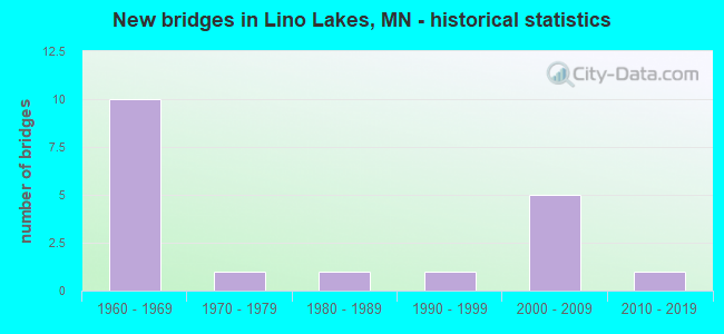
- New bridges - historical statistics
- 101960-1969
- 11970-1979
- 11980-1989
- 11990-1999
- 52000-2009
- 12010-2019
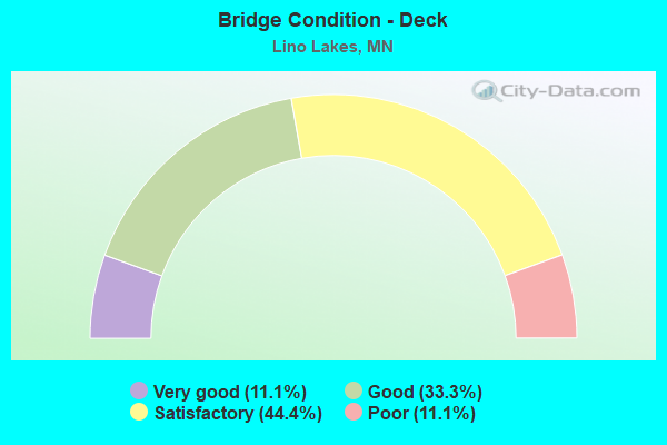
- Bridge Condition - Deck
- 11.1%Very good
- 33.3%Good
- 44.4%Satisfactory
- 11.1%Poor
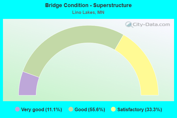
- Bridge Condition - Superstructure
- 11.1%Very good
- 55.6%Good
- 33.3%Satisfactory
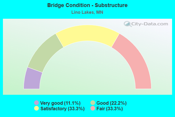
- Bridge Condition - Substructure
- 11.1%Very good
- 22.2%Good
- 33.3%Satisfactory
- 33.3%Fair

- Bridge Condition - Channel
- 33.3%Satisfactory
- 66.7%Fair
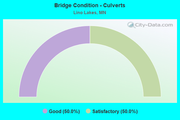
- Bridge Condition - Culverts
- 50.0%Good
- 50.0%Satisfactory
Find on map >> Show street view
Structure Number: 2554, Location: 0.2 MI E OF JCT TH 49 (Lat: 45.163608, Lng: -93.115639), Route carried "on" structure: City street 31, Year Built: 1991, Status: Open, Structure Length: 1.89m (6.20ft), Average Daily Traffic: 430 (year 1995), Average Future Daily Traffic: 430 (year 2034), Design Load: HS 20, Features Intersected: RICE CREEK
Minimum Vertical Clearance: 30+ m (98+ ft), Kilometerpoint: 0.000, Lanes on structure: 2, Owner: Local Park, Forest, or Reservation Agency, Approaching Roadway Width: 9.8m (32.2ft), Material/Design: Wood or Timber, Design/Construction: Slab, Number Of Spans In Main Unit: 3, Length of Maximum Span: 6.7m (22.0ft), Curb or Sidewalk Widths: Left: 2.4m (7.9ft), Right: 0.0m, Curb-To-Curb Width: 9.8m (32.2ft), Out-to-Out Width: 10.5m (34.4ft)
Condition: Deck: Good, Superstructure: Good, Substructure: Satisfactory, Channel: Satisfactory, Operating Rating: 63.3 metric tons, Method Used To Determine Operating Rating: Allowable Stress (AS), Inventory Rating: 46.1 metric tons, Method Used To Determine Inventory Rating: Allowable Stress (AS), Structural Evaluation: Equal to present minimum criteria, Deck Geometry: Equal to present minimum criteria, Waterway Adequacy: Superior to present desirable criteria, Approach Roadway Alignment: Equal to present minimum criteria, Designated Inspection Frequency: Every 24 months, Inspection Date: October 2021, Deck Structure Type: Wood or Timber, Wearing Surface/Protective System: Wearing Surface: Bituminous
Find on map >> Show street view
Structure Number: 2802, Location: 1.5 MI S OF JCT TH 35W (Lat: 45.196500, Lng: -93.029822), Route carried "on" structure: County highway 140, Year Built: 1965, Status: Open, Structure Length: 6.40m (21.00ft), Average Daily Traffic: 1,550 (year 2017), Average Future Daily Traffic: 1,550 (year 2039), Design Load: H 20, Features Intersected: I 35E
Minimum Vertical Clearance: 30+ m (98+ ft), Kilometerpoint: 0.000, Lanes on structure: 2, Lanes under structure: 4, Owner: State Highway Agency, Approaching Roadway Width: 12.2m (40.0ft), Material/Design: Prestressed concrete, Design/Construction: Stringer/Multi-beam, Number Of Spans In Main Unit: 4, Length of Maximum Span: 20.5m (67.3ft), Curb-To-Curb Width: 8.5m (27.9ft), Out-to-Out Width: 10.3m (33.8ft)
Condition: Deck: Satisfactory, Superstructure: Satisfactory, Substructure: Satisfactory, Operating Rating: 47.8 metric tons, Method Used To Determine Operating Rating: Load Factor (LF), Inventory Rating: 28.8 metric tons, Method Used To Determine Inventory Rating: Load Factor (LF), Structural Evaluation: Equal to present minimum criteria, Deck Geometry: Somewhat better than minimum adequacy, Underclear: High priority of corrective action, Approach Roadway Alignment: Equal to present desirable criteria, Designated Inspection Frequency: Every 24 months, Inspection Date: May 2020, Deck Structure Type: Concrete Cast-file-Place, Wearing Surface/Protective System: Wearing Surface: Low Slump Concrete
Find on map >> Show street view
Structure Number: 2812, Location: 3.8 MI S OF JCT TH 35W (Lat: 45.164139, Lng: -93.031281), Route carried "on" structure: County highway 14, Year Built: 2009, Status: Open, Structure Length: 7.64m (25.07ft), Average Daily Traffic: 16,600 (year 2017), Average Future Daily Traffic: 16,600 (year 2039), Design Load: HL 93, Features Intersected: I 35E
Minimum Vertical Clearance: 30+ m (98+ ft), Kilometerpoint: 0.000, Lanes on structure: 4, Lanes under structure: 6, Owner: State Highway Agency, Approaching Roadway Width: 29.9m (98.1ft), Skew: 20 degrees, Material/Design: Prestressed concrete, Design/Construction: Stringer/Multi-beam, Number Of Spans In Main Unit: 2, Length of Maximum Span: 42.1m (138.1ft), Curb or Sidewalk Widths: Left: 0.0m, Right: 3.5m (11.5ft), Curb-To-Curb Width: 29.9m (98.1ft), Out-to-Out Width: 35.4m (116.1ft)
Condition: Deck: Very good, Superstructure: Very good, Substructure: Very good, Operating Rating: 49.6 metric tons, Method Used To Determine Operating Rating: Load and Resistance Factor Rating (LRFR) rating reported by rating factor(RF) method using HL-93 loadings, Inventory Rating: 38.2 metric tons, Method Used To Determine Inventory Rating: Load and Resistance Factor Rating (LRFR) rating reported by rating factor(RF) method using HL-93 loadings, Structural Evaluation: Equal to present desirable criteria, Deck Geometry: Superior to present desirable criteria, Underclear: Equal to present minimum criteria, Approach Roadway Alignment: Equal to present desirable criteria, Designated Inspection Frequency: Every 24 months, Inspection Date: May 2020, Deck Structure Type: Concrete Cast-file-Place, Wearing Surface/Protective System: Wearing Surface: Low Slump Concrete, Deck Protection: Epoxy Coated Reinforcing
Find on map >> Show street view
Structure Number: 2817, Location: 5.0 MI SW JCT TH 35E (Lat: 45.180181, Lng: -93.112961), Route carried "on" structure: County highway 23, Year Built: 2008, Status: Open, Structure Length: 8.66m (28.41ft), Average Daily Traffic: 19,900 (year 2019), Truck Traffic: 6%, Average Future Daily Traffic: 19,700 (year 2039), Design Load: HL 93, Features Intersected: I 35W
Minimum Vertical Clearance: 30+ m (98+ ft), Kilometerpoint: 0.000, Lanes on structure: 4, Lanes under structure: 4, Base Highway Network: Yes, Owner: State Highway Agency, Approaching Roadway Width: 21.3m (69.9ft), Skew: 25 degrees, Material/Design: Prestressed concrete, Design/Construction: Stringer/Multi-beam, Number Of Spans In Main Unit: 2, Length of Maximum Span: 40.7m (133.5ft), Curb or Sidewalk Widths: Left: 0.0m, Right: 3.7m (12.1ft), Curb-To-Curb Width: 21.3m (69.9ft), Out-to-Out Width: 36.1m (118.4ft)
Condition: Deck: Good, Superstructure: Good, Substructure: Good, Operating Rating: 99.6 metric tons, Method Used To Determine Operating Rating: Load Factor (LF), Inventory Rating: 41.2 metric tons, Method Used To Determine Inventory Rating: Load Factor (LF), Structural Evaluation: Better than present minimum criteria, Deck Geometry: Superior to present desirable criteria, Underclear: Somewhat better than minimum adequacy, Approach Roadway Alignment: Equal to present desirable criteria, Designated Inspection Frequency: Every 24 months, Inspection Date: April 2020, Deck Structure Type: Concrete Cast-file-Place, Wearing Surface/Protective System: Wearing Surface: Low Slump Concrete, Deck Protection: Epoxy Coated Reinforcing
Find on map >> Show street view
Structure Number: 9823, Location: 3.5 MI S OF JCT TH 210 (Lat: 46.628269, Lng: -92.531914), Route carried "on" structure: Interstate 35, Year Built: 1965, Year Reconstructed: 1982, Status: Open, Structure Length: 9.85m (32.32ft), Average Daily Traffic: 8,850 (year 2016), Truck Traffic: 7%, Average Future Daily Traffic: 8,850 (year 2039), Design Load: HS 20+Mod, Features Intersected: CSAH 61
Minimum Vertical Clearance: 30+ m (98+ ft), Kilometerpoint: 0.000, Lanes on structure: 2, Lanes under structure: 2, Base Highway Network: Yes, Owner: State Highway Agency, Approaching Roadway Width: 11.6m (38.1ft), Skew: 4 degrees, Material/Design: Steel continuous, Design/Construction: Stringer/Multi-beam, Number Of Spans In Main Unit: 4, Length of Maximum Span: 27.4m (89.9ft), Curb-To-Curb Width: 12.1m (39.7ft), Out-to-Out Width: 13.1m (43.0ft)
Condition: Deck: Poor, Superstructure: Satisfactory, Substructure: Satisfactory, Operating Rating: 55.5 metric tons, Method Used To Determine Operating Rating: Load Factor (LF), Inventory Rating: 33.3 metric tons, Method Used To Determine Inventory Rating: Load Factor (LF), Structural Evaluation: Equal to present minimum criteria, Deck Geometry: Equal to present minimum criteria, Underclear: Equal to present minimum criteria, Approach Roadway Alignment: Equal to present desirable criteria, Designated Inspection Frequency: Every 12 months, Inspection Date: June 2021, Deck Structure Type: Concrete Cast-file-Place, Wearing Surface/Protective System: Wearing Surface: Epoxy Overlay
Find on map >> Show street view
Structure Number: 983, Location: 6.6 MI SW OF W JCT TH 2 (Lat: 46.699981, Lng: -92.321983), Route carried "on" structure: County highway 389, Year Built: 1971, Status: Open, Structure Length: 8.73m (28.64ft), Average Daily Traffic: 42 (year 1970), Average Future Daily Traffic: 42 (year 2029), Design Load: HS 20, Features Intersected: I 35
Minimum Vertical Clearance: 30+ m (98+ ft), Kilometerpoint: 0.000, Lanes on structure: 2, Lanes under structure: 4, Owner: State Highway Agency, Approaching Roadway Width: 9.8m (32.2ft), Skew: 1 degrees, Material/Design: Prestressed concrete, Design/Construction: Stringer/Multi-beam, Number Of Spans In Main Unit: 4, Length of Maximum Span: 26.9m (88.3ft), Curb-To-Curb Width: 9.8m (32.2ft), Out-to-Out Width: 10.9m (35.8ft)
Condition: Deck: Good, Superstructure: Good, Substructure: Good, Operating Rating: 61.7 metric tons, Method Used To Determine Operating Rating: Load Factor (LF), Inventory Rating: 28.1 metric tons, Method Used To Determine Inventory Rating: Load Factor (LF), Structural Evaluation: Better than present minimum criteria, Deck Geometry: Equal to present desirable criteria, Underclear: Equal to present minimum criteria, Approach Roadway Alignment: Equal to present desirable criteria, Designated Inspection Frequency: Every 24 months, Inspection Date: September 2020, Deck Structure Type: Concrete Cast-file-Place, Wearing Surface/Protective System: Wearing Surface: Low Slump Concrete
Find on map >> Show street view
Structure Number: 62836, Location: 6.6 MI S OF JCT TH 35W (Lat: 45.123981, Lng: -93.049683), Route carried "on" structure: County highway 60, Year Built: 1967, Status: Open, Structure Length: 5.78m (18.96ft), Average Daily Traffic: 10,500 (year 2014), Average Future Daily Traffic: 10,500 (year 2039), Design Load: HS 20, Features Intersected: I 35E
Minimum Vertical Clearance: 30+ m (98+ ft), Kilometerpoint: 0.000, Lanes on structure: 2, Lanes under structure: 4, Owner: State Highway Agency, Approaching Roadway Width: 13.4m (44.0ft), Material/Design: Prestressed concrete, Design/Construction: Stringer/Multi-beam, Number Of Spans In Main Unit: 4, Length of Maximum Span: 17.5m (57.4ft), Curb-To-Curb Width: 9.1m (29.9ft), Out-to-Out Width: 10.9m (35.8ft)
Condition: Deck: Satisfactory, Superstructure: Satisfactory, Substructure: Fair, Operating Rating: 50.8 metric tons, Method Used To Determine Operating Rating: Load Factor (LF), Inventory Rating: 30.4 metric tons, Method Used To Determine Inventory Rating: Load Factor (LF), Structural Evaluation: Somewhat better than minimum adequacy, Deck Geometry: High priority of corrective action, Underclear: Somewhat better than minimum adequacy, Approach Roadway Alignment: Equal to present desirable criteria, Length Of Structure Improvement: 1.95m (6.40ft), Designated Inspection Frequency: Every 24 months, Inspection Date: May 2020, Bridge Improvement Cost: $999,999,000, Deck Structure Type: Concrete Cast-file-Place, Wearing Surface/Protective System: Wearing Surface: Low Slump Concrete
Find on map >> Show street view
Structure Number: 96424, Location: 0.8 MI E OF JCT CSAH 21 (Lat: 45.196442, Lng: -93.023689), Route carried "on" structure: County highway 140, Year Built: 1989, Status: Open, Structure Length: 0.68m (2.23ft), Average Daily Traffic: 1,550 (year 2017), Truck Traffic: 10%, Average Future Daily Traffic: 1,550 (year 2039), Design Load: HS 20, Features Intersected: HARDWOOD CREEK
Minimum Vertical Clearance: 30+ m (98+ ft), Kilometerpoint: 0.000, Lanes on structure: 2, Owner: County Highway Agency, Approaching Roadway Width: 12.2m (40.0ft), Skew: 1 degrees, Material/Design: Concrete, Design/Construction: Culvert, Number Of Spans In Main Unit: 2, Length of Maximum Span: 2.5m (8.2ft)
Condition: Channel: Fair, Culverts: Good, Operating Rating: 58.8 metric tons, Method Used To Determine Operating Rating: Assigned rating based on Load Factor Design (LFD) reported in metric tons, Inventory Rating: 39.2 metric tons, Method Used To Determine Inventory Rating: Assigned rating based on Load Factor Design (LFD) reported in metric tons, Structural Evaluation: Better than present minimum criteria, Waterway Adequacy: Equal to present desirable criteria, Approach Roadway Alignment: Equal to present desirable criteria, Designated Inspection Frequency: Every 24 months, Inspection Date: October 2021
Find on map >> Show street view
Structure Number: 9823, Location: 3.6 MI NE OF JCT TH 49 (Lat: 45.203167, Lng: -93.048539), Route carried "on" structure: Interstate 35W, Year Built: 1967, Status: Open, Structure Length: 0.99m (3.25ft), Average Daily Traffic: 36,000 (year 2019), Truck Traffic: 6%, Average Future Daily Traffic: 43,000 (year 2039), Features Intersected: RICE CREEK
Minimum Vertical Clearance: 30+ m (98+ ft), Kilometerpoint: 0.000, Lanes on structure: 4, Base Highway Network: Yes, Owner: State Highway Agency, Approaching Roadway Width: 33.2m (108.9ft), Skew: 10 degrees, Material/Design: Concrete, Design/Construction: Culvert, Number Of Spans In Main Unit: 3, Length of Maximum Span: 3.0m (9.8ft)
Condition: Channel: Fair, Culverts: Satisfactory, Operating Rating: 39.2 metric tons, Method Used To Determine Operating Rating: Assigned ratings based on Allowable Stress Design (ASD) reported in metric tons, Inventory Rating: 29.4 metric tons, Method Used To Determine Inventory Rating: Assigned ratings based on Allowable Stress Design (ASD) reported in metric tons, Structural Evaluation: Equal to present minimum criteria, Waterway Adequacy: Equal to present minimum criteria, Approach Roadway Alignment: Equal to present desirable criteria, Designated Inspection Frequency: Every 24 months, Underwater Inspection Frequency: Every 60 months, Inspection Date: April 2020, Underwater Inspection Date: May 2021
Find on map >> Show street view
Structure Number: 983, Location: 2.2 MI NE OF JCT TH 49 (Lat: 45.192750, Lng: -93.072900), Route carried "on" structure: County highway 14, Year Built: 1967, Status: Open, Structure Length: 5.47m (17.95ft), Average Daily Traffic: 9,791 (year 2019), Truck Traffic: 3%, Average Future Daily Traffic: 10,200 (year 2039), Design Load: H 20, Features Intersected: I 35W
Minimum Vertical Clearance: 30+ m (98+ ft), Kilometerpoint: 0.000, Lanes on structure: 2, Lanes under structure: 4, Owner: State Highway Agency, Approaching Roadway Width: 14.6m (47.9ft), Skew: 1 degrees, Material/Design: Prestressed concrete, Design/Construction: Stringer/Multi-beam, Number Of Spans In Main Unit: 4, Length of Maximum Span: 18.1m (59.4ft), Curb-To-Curb Width: 8.5m (27.9ft), Out-to-Out Width: 10.2m (33.5ft)
Condition: Deck: Satisfactory, Superstructure: Good, Substructure: Fair, Operating Rating: 67.8 metric tons, Method Used To Determine Operating Rating: Load Factor (LF), Inventory Rating: 39.8 metric tons, Method Used To Determine Inventory Rating: Load Factor (LF), Structural Evaluation: Somewhat better than minimum adequacy, Deck Geometry: High priority of replacement, Underclear: Meets minimum limits, Approach Roadway Alignment: Equal to present desirable criteria, Length Of Structure Improvement: 1.83m (6.00ft), Designated Inspection Frequency: Every 24 months, Inspection Date: April 2020, Bridge Improvement Cost: $999,999,000, Deck Structure Type: Concrete Cast-file-Place, Wearing Surface/Protective System: Wearing Surface: Low Slump Concrete
Find on map >> Show street view
Structure Number: 9831, Location: 1.7 MI SW OF JCT TH 49 (Lat: 45.168122, Lng: -93.142897), Route carried "on" structure: County highway 53, Year Built: 1967, Status: Open, Structure Length: 7.06m (23.16ft), Average Daily Traffic: 5,700 (year 2016), Average Future Daily Traffic: 5,700 (year 2039), Design Load: HS 20, Features Intersected: I 35W
Minimum Vertical Clearance: 30+ m (98+ ft), Kilometerpoint: 0.000, Lanes on structure: 2, Lanes under structure: 4, Owner: State Highway Agency, Approaching Roadway Width: 12.2m (40.0ft), Skew: 3 degrees, Material/Design: Steel continuous, Design/Construction: Stringer/Multi-beam, Number Of Spans In Main Unit: 4, Length of Maximum Span: 24.1m (79.1ft), Curb or Sidewalk Widths: Left: 0.8m (2.6ft), Right: 0.8m (2.6ft), Curb-To-Curb Width: 9.1m (29.9ft), Out-to-Out Width: 11.5m (37.7ft)
Condition: Deck: Satisfactory, Superstructure: Good, Substructure: Fair, Operating Rating: 60.2 metric tons, Method Used To Determine Operating Rating: Load Factor (LF), Inventory Rating: 36.1 metric tons, Method Used To Determine Inventory Rating: Load Factor (LF), Structural Evaluation: Somewhat better than minimum adequacy, Deck Geometry: Meets minimum limits, Underclear: Somewhat better than minimum adequacy, Approach Roadway Alignment: Equal to present desirable criteria, Length Of Structure Improvement: 2.38m (7.81ft), Designated Inspection Frequency: Every 24 months, Inspection Date: April 2020, Bridge Improvement Cost: $836,000,000, Roadway Improvement Cost: $71,000,000, Total Project Cost: $999,999,000, Deck Structure Type: Concrete Cast-file-Place, Wearing Surface/Protective System: Wearing Surface: Low Slump Concrete
Find on map >> Show street view
Structure Number: 2006, Location: 2.2 MI NE OF JCT CSAH 23 (Lat: 45.192647, Lng: -93.073075), Route carried "under" structure: Interstate 35W, Year Built: 2013, Structure Length: 0. m, Average Daily Traffic: 36,000 (year 2019), Truck Traffic: 6%, Features Intersected: I 35W, Facility Carried by Structure: PEDESTRIAN
Minimum Vertical Clearance: 5.30m (17.39ft), Kilometerpoint: 0.000, Lanes under structure: 4, Material/Design: Prestressed concrete, Design/Construction: Girder and Floorbeam System, Length of Maximum Span: 29.5m (96.8ft)
Find on map >> Show street view
Structure Number: 2802, Location: 1.5 MI S OF JCT TH 35W (Lat: 45.196500, Lng: -93.029822), Route carried "under" structure: Interstate 35E, Year Built: 1965, Structure Length: 0. m, Average Daily Traffic: 39,500 (year 2019), Truck Traffic: 4%, Features Intersected: I 35E, Facility Carried by Structure: CR 140
Minimum Vertical Clearance: 5.12m (16.80ft), Kilometerpoint: 0.000, Lanes on structure: 2, Lanes under structure: 4, Material/Design: Prestressed concrete, Design/Construction: Stringer/Multi-beam, Length of Maximum Span: 20.5m (67.3ft)
Find on map >> Show street view
Structure Number: 2812, Location: 3.8 MI S OF JCT TH 35W (Lat: 45.164139, Lng: -93.031281), Route carried "under" structure: Interstate 35E, Year Built: 2009, Structure Length: 0. m, Average Daily Traffic: 50,000 (year 2019), Truck Traffic: 4%, Features Intersected: I 35E, Facility Carried by Structure: CSAH 14
Minimum Vertical Clearance: 5.03m (16.50ft), Kilometerpoint: 0.000, Lanes under structure: 5, Material/Design: Prestressed concrete, Design/Construction: Stringer/Multi-beam, Length of Maximum Span: 42.1m (138.1ft)
Find on map >> Show street view
Structure Number: 2812, Location: 3.8 MI S OF JCT TH 35W (Lat: 45.164139, Lng: -93.031281), Route carried "under" structure: Ramp Interstate 6546, Year Built: 2009, Structure Length: 0. m, Average Daily Traffic: 1 (year 2019), Features Intersected: I 35E, Facility Carried by Structure: CSAH 14
Minimum Vertical Clearance: 4.88m (16.01ft), Kilometerpoint: 0.000, Lanes under structure: 1, Material/Design: Prestressed concrete, Design/Construction: Stringer/Multi-beam, Length of Maximum Span: 42.1m (138.1ft)
Find on map >> Show street view
Structure Number: 2817, Location: 5.0 MI SW JCT TH 35E (Lat: 45.180181, Lng: -93.112961), Route carried "under" structure: Interstate 35W, Year Built: 2008, Structure Length: 0. m, Average Daily Traffic: 36,000 (year 2019), Truck Traffic: 6%, Features Intersected: I 35W, Facility Carried by Structure: CSAH 23
Minimum Vertical Clearance: 5.06m (16.60ft), Kilometerpoint: 0.000, Lanes on structure: 4, Lanes under structure: 4, Material/Design: Prestressed concrete, Design/Construction: Stringer/Multi-beam, Length of Maximum Span: 40.7m (133.5ft)
Find on map >> Show street view
Structure Number: 62836, Location: 6.6 MI S OF JCT TH 35W (Lat: 45.123981, Lng: -93.049683), Route carried "under" structure: Interstate 35E, Year Built: 1967, Structure Length: 0. m, Average Daily Traffic: 50,000 (year 2019), Truck Traffic: 4%, Features Intersected: I 35E, Facility Carried by Structure: CSAH 60
Minimum Vertical Clearance: 4.97m (16.31ft), Kilometerpoint: 0.000, Lanes on structure: 2, Lanes under structure: 4, Material/Design: Prestressed concrete, Design/Construction: Stringer/Multi-beam, Length of Maximum Span: 17.5m (57.4ft)
Find on map >> Show street view
Structure Number: 983, Location: 2.2 MI NE OF JCT TH 49 (Lat: 45.192750, Lng: -93.072900), Route carried "under" structure: Interstate 35W, Year Built: 1967, Structure Length: 0. m, Average Daily Traffic: 36,000 (year 2019), Truck Traffic: 6%, Features Intersected: I 35W, Facility Carried by Structure: CSAH 14
Minimum Vertical Clearance: 4.79m (15.72ft), Kilometerpoint: 0.000, Lanes on structure: 2, Lanes under structure: 4, Material/Design: Prestressed concrete, Design/Construction: Stringer/Multi-beam, Length of Maximum Span: 18.1m (59.4ft)
Find on map >> Show street view
Structure Number: 9831, Location: 1.7 MI SW OF JCT TH 49 (Lat: 45.168122, Lng: -93.142897), Route carried "under" structure: Interstate 35W, Year Built: 1967, Structure Length: 0. m, Average Daily Traffic: 47,500 (year 2019), Truck Traffic: 5%, Features Intersected: I 35W, Facility Carried by Structure: CR 53
Minimum Vertical Clearance: 4.85m (15.91ft), Kilometerpoint: 0.000, Lanes on structure: 2, Lanes under structure: 4, Material/Design: Steel continuous, Design/Construction: Stringer/Multi-beam, Length of Maximum Span: 24.1m (79.1ft)