Bridge Statistics for Lindon, Utah (UT)
Condition, Traffic, Stress, Structural Evaluation, Project Costs
- National Bridge Inventory (NBI) Statistics
- 12Number of bridges
- 167ft / 51.4mTotal length
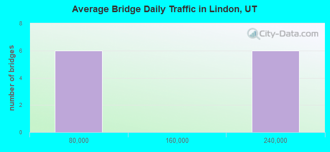
- 1,261,016Total average daily traffic
- 244,344Total average daily truck traffic
- National Bridge Inventory (NBI) Registered Bridges for Lindon
- No street view available for this location
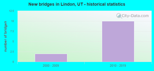
- New bridges - historical statistics
- 22000-2009
- 102010-2019
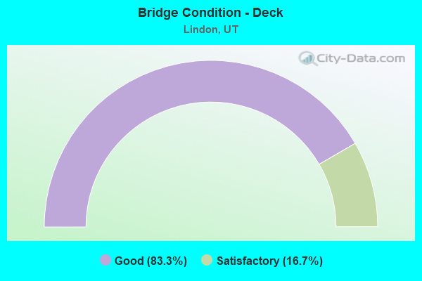
- Bridge Condition - Deck
- 83.3%Good
- 16.7%Satisfactory

- Bridge Condition - Superstructure
- 66.7%Very good
- 33.3%Good
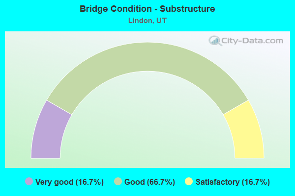
- Bridge Condition - Substructure
- 16.7%Very good
- 66.7%Good
- 16.7%Satisfactory
Find on map >> Show street view
Structure Number: C 992, Location: Southwest Lindon (Lat: 40.333519, Lng: -111.744003), Route carried "on" structure: City street 2943, Year Built: 2011, Status: Open, Structure Length: 10.05m (32.97ft), Average Daily Traffic: 1,000 (year 2020), Average Future Daily Traffic: 1,250 (year 2040), Design Load: HL 93, Features Intersected: I-15, (SR-15), Facility Carried by Structure: 2000 SO. in LINDON
Minimum Vertical Clearance: 30+ m (98+ ft), Kilometerpoint: 0.453, Lanes on structure: 2, Lanes under structure: 12, Owner: State Highway Agency, Approaching Roadway Width: 16.5m (54.1ft), Skew: 24 degrees, Material/Design: Steel continuous, Design/Construction: Stringer/Multi-beam, Number Of Spans In Main Unit: 2, Length of Maximum Span: 49.5m (162.4ft), Curb or Sidewalk Widths: Left: 1.8m (5.9ft), Right: 1.8m (5.9ft), Curb-To-Curb Width: 16.5m (54.1ft), Out-to-Out Width: 21.0m (68.9ft)
Condition: Deck: Good, Superstructure: Very good, Substructure: Good, Operating Rating: 57.3 metric tons, Method Used To Determine Operating Rating: Load and Resistance Factor Rating (LRFR) rating reported by rating factor(RF) method using HL-93 loadings, Inventory Rating: 38.2 metric tons, Method Used To Determine Inventory Rating: Load and Resistance Factor Rating (LRFR) rating reported by rating factor(RF) method using HL-93 loadings, Structural Evaluation: Better than present minimum criteria, Deck Geometry: Superior to present desirable criteria, Underclear: Equal to present minimum criteria, Approach Roadway Alignment: Better than present minimum criteria, Designated Inspection Frequency: Every 24 months, Inspection Date: Febuary 2021, Deck Structure Type: Concrete Cast-file-Place, Wearing Surface/Protective System: Wearing Surface: Epoxy Overlay, Deck Protection: Epoxy Coated Reinforcing
Find on map >> Show street view
Structure Number: F 682, Location: AT PLEASANT GR.INTCHG. (Lat: 40.349525, Lng: -111.769033), Route carried "on" structure: City street 135, Year Built: 2002, Status: Open, Structure Length: 7.16m (23.49ft), Average Daily Traffic: 2,829 (year 2020), Truck Traffic: 24%, Average Future Daily Traffic: 3,536 (year 2040), Design Load: HS 20, Features Intersected: I-15 (SR-15), Facility Carried by Structure: PLEASANT GR.BLVD.
Minimum Vertical Clearance: 30+ m (98+ ft), Kilometerpoint: 0.529, Lanes on structure: 4, Lanes under structure: 12, Owner: State Highway Agency, Approaching Roadway Width: 30.0m (98.4ft), Skew: 20 degrees, Material/Design: Prestressed concrete continuous, Design/Construction: Stringer/Multi-beam, Number Of Spans In Main Unit: 2, Length of Maximum Span: 35.3m (115.8ft), Curb or Sidewalk Widths: Left: 2.0m (6.6ft), Right: 0.0m, Curb-To-Curb Width: 30.0m (98.4ft), Out-to-Out Width: 33.5m (109.9ft)
Condition: Deck: Satisfactory, Superstructure: Good, Substructure: Satisfactory, Operating Rating: 75.8 metric tons, Method Used To Determine Operating Rating: Load and Resistance Factor Rating (LRFR) rating reported by rating factor(RF) method using HL-93 loadings, Inventory Rating: 36.9 metric tons, Method Used To Determine Inventory Rating: Load and Resistance Factor Rating (LRFR) rating reported by rating factor(RF) method using HL-93 loadings, Structural Evaluation: Equal to present minimum criteria, Deck Geometry: Superior to present desirable criteria, Underclear: Equal to present minimum criteria, Approach Roadway Alignment: Equal to present desirable criteria, Designated Inspection Frequency: Every 24 months, Inspection Date: Febuary 2021, Deck Structure Type: Concrete Cast-file-Place, Wearing Surface/Protective System: Wearing Surface: Epoxy Overlay, Deck Protection: Epoxy Coated Reinforcing
Find on map >> Show street view
Structure Number: F 813, Location: SW side of Lindon City (Lat: 40.343911, Lng: -111.760703), Route carried "on" structure: City street 2943, Year Built: 2011, Status: Open, Structure Length: 10.03m (32.91ft), Average Daily Traffic: 1,000 (year 2020), Average Future Daily Traffic: 1,250 (year 2040), Design Load: HL 93, Features Intersected: I-15, (SR-15), Facility Carried by Structure: PROCTOR LANE
Minimum Vertical Clearance: 30+ m (98+ ft), Kilometerpoint: 3.018, Lanes on structure: 2, Lanes under structure: 13, Owner: State Highway Agency, Approaching Roadway Width: 16.5m (54.1ft), Skew: 21 degrees, Material/Design: Prestressed concrete continuous, Design/Construction: Stringer/Multi-beam, Number Of Spans In Main Unit: 3, Length of Maximum Span: 36.9m (121.1ft), Curb or Sidewalk Widths: Left: 1.8m (5.9ft), Right: 1.8m (5.9ft), Curb-To-Curb Width: 16.5m (54.1ft), Out-to-Out Width: 21.0m (68.9ft)
Condition: Deck: Good, Superstructure: Good, Substructure: Good, Operating Rating: 61.9 metric tons, Method Used To Determine Operating Rating: Load and Resistance Factor Rating (LRFR) rating reported by rating factor(RF) method using HL-93 loadings, Inventory Rating: 35.6 metric tons, Method Used To Determine Inventory Rating: Load and Resistance Factor Rating (LRFR) rating reported by rating factor(RF) method using HL-93 loadings, Structural Evaluation: Better than present minimum criteria, Deck Geometry: Superior to present desirable criteria, Underclear: Equal to present minimum criteria, Approach Roadway Alignment: Equal to present desirable criteria, Designated Inspection Frequency: Every 24 months, Inspection Date: Febuary 2021, Deck Structure Type: Concrete Cast-file-Place, Wearing Surface/Protective System: Wearing Surface: Epoxy Overlay, Deck Protection: Epoxy Coated Reinforcing
Find on map >> Show street view
Structure Number: 1C 993, Location: SW EDGE of LINDON (Lat: 40.330111, Lng: -111.737786), Route carried "on" structure: Interstate 15, Year Built: 2011, Status: Open, Structure Length: 8.98m (29.46ft), Average Daily Traffic: 200,425 (year 2020), Truck Traffic: 19%, Average Future Daily Traffic: 250,531 (year 2040), Design Load: HL 93, Features Intersected: SR-114, GENEVA ROAD
Minimum Vertical Clearance: 30+ m (98+ ft), Kilometerpoint: 440.205, Lanes on structure: 7, Lanes under structure: 4, Base Highway Network: Yes, Owner: State Highway Agency, Approaching Roadway Width: 33.4m (109.6ft), Skew: 34 degrees, Material/Design: Steel continuous, Design/Construction: Stringer/Multi-beam, Number Of Spans In Main Unit: 2, Length of Maximum Span: 45.5m (149.3ft), Curb-To-Curb Width: 33.4m (109.6ft), Out-to-Out Width: 34.2m (112.2ft)
Condition: Deck: Good, Superstructure: Very good, Substructure: Good, Operating Rating: 42.4 metric tons, Method Used To Determine Operating Rating: Load and Resistance Factor Rating (LRFR) rating reported by rating factor(RF) method using HL-93 loadings, Inventory Rating: 30.5 metric tons, Method Used To Determine Inventory Rating: Load and Resistance Factor Rating (LRFR) rating reported by rating factor(RF) method using HL-93 loadings, Structural Evaluation: Better than present minimum criteria, Deck Geometry: Superior to present desirable criteria, Underclear: Meets minimum limits, Approach Roadway Alignment: Equal to present desirable criteria, Designated Inspection Frequency: Every 24 months, Inspection Date: Febuary 2021, Deck Structure Type: Concrete Cast-file-Place, Wearing Surface/Protective System: Wearing Surface: Epoxy Overlay, Deck Protection: Epoxy Coated Reinforcing
Find on map >> Show street view
Structure Number: 3C 993, Location: Southwest edge of Lindon (Lat: 40.330403, Lng: -111.738661), Route carried "on" structure: Interstate 15, Year Built: 2011, Status: Open, Structure Length: 8.98m (29.46ft), Average Daily Traffic: 200,425 (year 2020), Truck Traffic: 19%, Average Future Daily Traffic: 250,531 (year 2040), Design Load: HL 93, Features Intersected: SR-114, GENEVA ROAD
Minimum Vertical Clearance: 30+ m (98+ ft), Kilometerpoint: 440.064, Lanes on structure: 7, Lanes under structure: 4, Base Highway Network: Yes, Owner: State Highway Agency, Approaching Roadway Width: 33.4m (109.6ft), Skew: 34 degrees, Material/Design: Steel continuous, Design/Construction: Stringer/Multi-beam, Number Of Spans In Main Unit: 2, Length of Maximum Span: 45.5m (149.3ft), Curb-To-Curb Width: 33.4m (109.6ft), Out-to-Out Width: 34.2m (112.2ft)
Condition: Deck: Good, Superstructure: Very good, Substructure: Very good, Operating Rating: 48.9 metric tons, Method Used To Determine Operating Rating: Load and Resistance Factor Rating (LRFR) rating reported by rating factor(RF) method using HL-93 loadings, Inventory Rating: 30.5 metric tons, Method Used To Determine Inventory Rating: Load and Resistance Factor Rating (LRFR) rating reported by rating factor(RF) method using HL-93 loadings, Structural Evaluation: Better than present minimum criteria, Deck Geometry: Superior to present desirable criteria, Underclear: Equal to present minimum criteria, Approach Roadway Alignment: Equal to present desirable criteria, Designated Inspection Frequency: Every 24 months, Inspection Date: Febuary 2021, Deck Structure Type: Concrete Cast-file-Place, Wearing Surface/Protective System: Wearing Surface: Epoxy Overlay, Deck Protection: Epoxy Coated Reinforcing
Find on map >> Show street view
Structure Number: 3F 814, Location: At the 1600 NORTH INTCHG. (Lat: 40.326542, Lng: -111.732633), Route carried "on" structure: Interstate 15, Year Built: 2011, Status: Open, Structure Length: 6.19m (20.31ft), Average Daily Traffic: 201,720 (year 2020), Truck Traffic: 20%, Average Future Daily Traffic: 252,150 (year 2040), Design Load: HL 93, Features Intersected: 1600 NO.ST.INT.X-RD.
Minimum Vertical Clearance: 30+ m (98+ ft), Kilometerpoint: 439.397, Lanes on structure: 6, Lanes under structure: 6, Base Highway Network: Yes, Owner: State Highway Agency, Approaching Roadway Width: 29.9m (98.1ft), Skew: 14 degrees, Material/Design: Prestressed concrete continuous, Design/Construction: Stringer/Multi-beam, Number Of Spans In Main Unit: 2, Length of Maximum Span: 30.0m (98.4ft), Curb-To-Curb Width: 29.9m (98.1ft), Out-to-Out Width: 30.7m (100.7ft)
Condition: Deck: Good, Superstructure: Very good, Substructure: Good, Operating Rating: 56.4 metric tons, Method Used To Determine Operating Rating: Load and Resistance Factor Rating (LRFR) rating reported by rating factor(RF) method using HL-93 loadings, Inventory Rating: 35.3 metric tons, Method Used To Determine Inventory Rating: Load and Resistance Factor Rating (LRFR) rating reported by rating factor(RF) method using HL-93 loadings, Structural Evaluation: Better than present minimum criteria, Deck Geometry: Superior to present desirable criteria, Underclear: Meets minimum limits, Approach Roadway Alignment: Equal to present desirable criteria, Designated Inspection Frequency: Every 24 months, Inspection Date: January 2021, Deck Structure Type: Concrete Cast-file-Place, Wearing Surface/Protective System: Wearing Surface: Epoxy Overlay, Deck Protection: Epoxy Coated Reinforcing
Find on map >> Show street view
Structure Number: C 992, Location: Southwest Lindon (Lat: 40.333519, Lng: -111.744003), Route carried "under" structure: Interstate 15, Year Built: 2011, Structure Length: 0. m, Average Daily Traffic: 200,425 (year 2020), Truck Traffic: 19%, Features Intersected: I-15, (SR-15), Facility Carried by Structure: 2000 SO. in LINDON
Minimum Vertical Clearance: 5.28m (17.32ft), Kilometerpoint: 442.111, Lanes on structure: 2, Lanes under structure: 12, Material/Design: Steel continuous, Design/Construction: Stringer/Multi-beam, Length of Maximum Span: 49.5m (162.4ft)
Find on map >> Show street view
Structure Number: F 682, Location: AT PLEASANT GR.INTCHG. (Lat: 40.349525, Lng: -111.769033), Route carried "under" structure: Interstate 15, Year Built: 2002, Structure Length: 0. m, Average Daily Traffic: 200,425 (year 2020), Truck Traffic: 19%, Features Intersected: I-15 (SR-15), Facility Carried by Structure: PLEASANT GR.BLVD.
Minimum Vertical Clearance: 5.11m (16.77ft), Kilometerpoint: 443.097, Lanes on structure: 4, Lanes under structure: 12, Material/Design: Prestressed concrete continuous, Design/Construction: Stringer/Multi-beam, Length of Maximum Span: 35.3m (115.8ft)
Find on map >> Show street view
Structure Number: F 813, Location: SW side of Lindon City (Lat: 40.343911, Lng: -111.760703), Route carried "under" structure: Interstate 15, Year Built: 2011, Structure Length: 0. m, Average Daily Traffic: 200,425 (year 2020), Truck Traffic: 19%, Features Intersected: I-15, (SR-15), Facility Carried by Structure: PROCTOR LANE
Minimum Vertical Clearance: 5.21m (17.09ft), Kilometerpoint: 443.213, Lanes on structure: 2, Lanes under structure: 12, Material/Design: Prestressed concrete continuous, Design/Construction: Stringer/Multi-beam, Length of Maximum Span: 36.9m (121.1ft)
Find on map >> Show street view
Structure Number: 1C 993, Location: SW EDGE of LINDON (Lat: 40.330111, Lng: -111.737786), Route carried "under" structure: State highway 114, Year Built: 2011, Structure Length: 0. m, Average Daily Traffic: 17,171 (year 2020), Truck Traffic: 24%, Features Intersected: SR-114, GENEVA ROAD, Facility Carried by Structure: I-15NB, (SR-15)
Minimum Vertical Clearance: 7.26m (23.82ft), Kilometerpoint: 14.172, Lanes on structure: 7, Lanes under structure: 4, Material/Design: Steel continuous, Design/Construction: Stringer/Multi-beam, Length of Maximum Span: 45.5m (149.3ft)
Find on map >> Show street view
Structure Number: 3C 993, Location: Southwest edge of Lindon (Lat: 40.330403, Lng: -111.738661), Route carried "under" structure: State highway 114, Year Built: 2011, Structure Length: 0. m, Average Daily Traffic: 17,171 (year 2020), Truck Traffic: 24%, Features Intersected: SR-114, GENEVA ROAD, Facility Carried by Structure: I-15SB, (SR-15)
Minimum Vertical Clearance: 7.17m (23.52ft), Kilometerpoint: 14.135, Lanes on structure: 7, Lanes under structure: 4, Material/Design: Steel continuous, Design/Construction: Stringer/Multi-beam, Length of Maximum Span: 45.5m (149.3ft)
Find on map >> Show street view
Structure Number: 3F 814, Location: At the 1600 NORTH INTCHG. (Lat: 40.326542, Lng: -111.732633), Route carried "under" structure: City street , Year Built: 2011, Structure Length: 0. m, Average Daily Traffic: 18,000 (year 2020), Truck Traffic: 26%, Features Intersected: 1600 NO.ST.INT.X-RD., Facility Carried by Structure: I-15SB, (SR-15)
Minimum Vertical Clearance: 5.08m (16.67ft), Kilometerpoint: 0.000, Lanes on structure: 6, Lanes under structure: 6, Material/Design: Prestressed concrete continuous, Design/Construction: Stringer/Multi-beam, Length of Maximum Span: 30.0m (98.4ft)