Bridge Statistics for Lincoln University, Pennsylvania (PA)
Condition, Traffic, Stress, Structural Evaluation, Project Costs
- National Bridge Inventory (NBI) Statistics
- 20Number of bridges
- 115ft / 34.9mTotal length
- $1,877,000Total costs
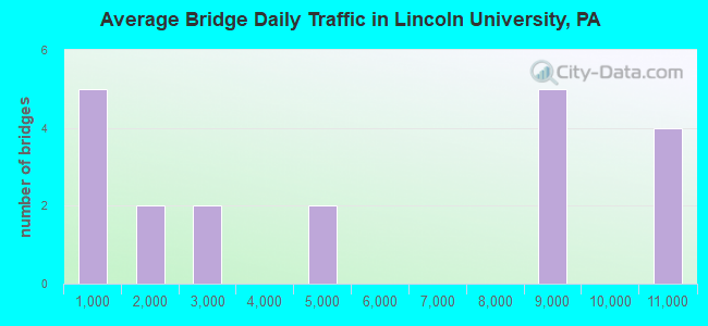
- 104,945Total average daily traffic
- 11,310Total average daily truck traffic
- National Bridge Inventory (NBI) Registered Bridges for Lincoln University
- No street view available for this location
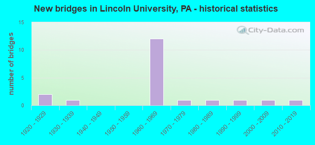
- New bridges - historical statistics
- 21920-1929
- 11930-1939
- 121960-1969
- 11970-1979
- 11980-1989
- 11990-1999
- 12000-2009
- 12010-2019
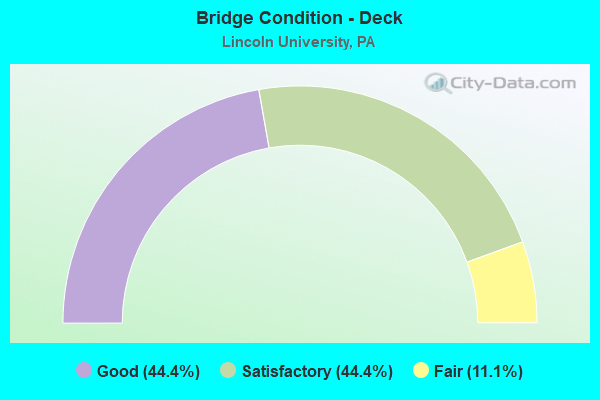
- Bridge Condition - Deck
- 44.4%Good
- 44.4%Satisfactory
- 11.1%Fair
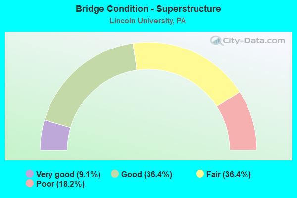
- Bridge Condition - Superstructure
- 9.1%Very good
- 36.4%Good
- 36.4%Fair
- 18.2%Poor
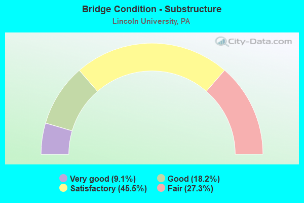
- Bridge Condition - Substructure
- 9.1%Very good
- 18.2%Good
- 45.5%Satisfactory
- 27.3%Fair
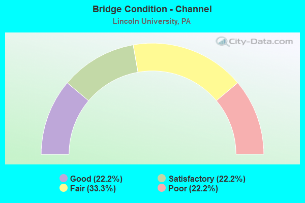
- Bridge Condition - Channel
- 22.2%Good
- 22.2%Satisfactory
- 33.3%Fair
- 22.2%Poor
Find on map >> Show street view
Structure Number: 9891, Location: 1.4MI.N.PA 10 INT. 44A09 (Lat: 39.813781, Lng: -75.942575), Route carried "on" structure: State highway , Year Built: 1968, Status: Open, Structure Length: 7.41m (24.31ft), Average Daily Traffic: 754 (year 2021), Truck Traffic: 12%, Average Future Daily Traffic: 819 (year 2032), Design Load: HS 20, Features Intersected: ROUTE 1 BY-PASS, Facility Carried by Structure: TOWNSHIP ROAD
Minimum Vertical Clearance: 30+ m (98+ ft), Kilometerpoint: 0.000, Lanes on structure: 2, Lanes under structure: 8, Owner: State Highway Agency, Approaching Roadway Width: 6.4m (21.0ft), Skew: 4 degrees, Material/Design: Prestressed concrete, Design/Construction: Stringer/Multi-beam, Number Of Spans In Main Unit: 4, Length of Maximum Span: 25.6m (84.0ft), Curb or Sidewalk Widths: Left: 0.2m (0.7ft), Right: 0.2m (0.7ft), Curb-To-Curb Width: 9.0m (29.5ft), Out-to-Out Width: 10.3m (33.8ft)
Condition: Deck: Good, Superstructure: Fair, Substructure: Satisfactory, Operating Rating: 45.4 metric tons, Method Used To Determine Operating Rating: Load Factor (LF), Inventory Rating: 20.9 metric tons, Method Used To Determine Inventory Rating: Load Factor (LF), Structural Evaluation: Somewhat better than minimum adequacy, Deck Geometry: Somewhat better than minimum adequacy, Underclear: High priority of corrective action, Approach Roadway Alignment: Equal to present minimum criteria, Length Of Structure Improvement: 8.40m (27.56ft), Designated Inspection Frequency: Every 24 months, Inspection Date: July 2021, Deck Structure Type: Concrete Cast-file-Place, Wearing Surface/Protective System: Wearing Surface: Latex Concrete
Find on map >> Show street view
Structure Number: 9894, Location: NEAR FORESTVILLE 44H08 (Lat: 39.824889, Lng: -75.898944), Route carried "on" structure: US 1, Year Built: 1967, Status: Open, Structure Length: 1.28m (4.20ft), Average Daily Traffic: 10,002 (year 2022), Truck Traffic: 12%, Average Future Daily Traffic: 11,520 (year 2032), Design Load: HS 20, Features Intersected: EAST BR. BIG ELK CREEK
Minimum Vertical Clearance: 30+ m (98+ ft), Kilometerpoint: 17.606, Lanes on structure: 2, Base Highway Network: Yes, Owner: State Highway Agency, Approaching Roadway Width: 11.3m (37.1ft), Skew: 20 degrees, Material/Design: Prestressed concrete, Design/Construction: Box Beam or Girders - Single/Spread, Number Of Spans In Main Unit: 1, Length of Maximum Span: 12.8m (42.0ft), Curb or Sidewalk Widths: Left: 0.1m (0.3ft), Right: 0.5m (1.6ft), Curb-To-Curb Width: 11.6m (38.1ft), Out-to-Out Width: 12.5m (41.0ft)
Condition: Deck: Good, Superstructure: Good, Substructure: Satisfactory, Channel: Satisfactory, Operating Rating: 61.7 metric tons, Method Used To Determine Operating Rating: Load Factor (LF), Inventory Rating: 31.8 metric tons, Method Used To Determine Inventory Rating: Load Factor (LF), Structural Evaluation: Equal to present minimum criteria, Deck Geometry: Equal to present minimum criteria, Waterway Adequacy: Equal to present desirable criteria, Approach Roadway Alignment: Equal to present desirable criteria, Length Of Structure Improvement: 1.90m (6.23ft), Designated Inspection Frequency: Every 24 months, Inspection Date: July 2021, Deck Structure Type: Concrete Cast-file-Place, Wearing Surface/Protective System: Wearing Surface: Bituminous
Find on map >> Show street view
Structure Number: 9895, Location: 1MI.SOUTH PA 796 44J7 (Lat: 39.825822, Lng: -75.891133), Route carried "on" structure: State highway , Year Built: 1967, Status: Open, Structure Length: 5.97m (19.59ft), Average Daily Traffic: 1,245 (year 2022), Truck Traffic: 8%, Average Future Daily Traffic: 1,193 (year 2032), Design Load: HS 20, Features Intersected: US 1 BY-PASS, Facility Carried by Structure: PUSEY MILL RD(T337
Minimum Vertical Clearance: 30+ m (98+ ft), Kilometerpoint: 0.000, Lanes on structure: 2, Lanes under structure: 8, Owner: State Highway Agency, Approaching Roadway Width: 11.0m (36.1ft), Skew: 4 degrees, Material/Design: Prestressed concrete, Design/Construction: Stringer/Multi-beam, Number Of Spans In Main Unit: 2, Length of Maximum Span: 28.7m (94.2ft), Curb or Sidewalk Widths: Left: 0.5m (1.6ft), Right: 0.5m (1.6ft), Curb-To-Curb Width: 9.9m (32.5ft), Out-to-Out Width: 11.4m (37.4ft)
Condition: Deck: Satisfactory, Superstructure: Fair, Substructure: Satisfactory, Operating Rating: 68.9 metric tons, Method Used To Determine Operating Rating: Load Factor (LF), Inventory Rating: 22.7 metric tons, Method Used To Determine Inventory Rating: Load Factor (LF), Structural Evaluation: Somewhat better than minimum adequacy, Deck Geometry: Somewhat better than minimum adequacy, Underclear: High priority of corrective action, Approach Roadway Alignment: Equal to present desirable criteria, Length Of Structure Improvement: 7.00m (22.97ft), Designated Inspection Frequency: Every 24 months, Inspection Date: June 2021, Bridge Improvement Cost: $38,000, Roadway Improvement Cost: $112,000, Total Project Cost: $513,000, Deck Structure Type: Concrete Cast-file-Place, Wearing Surface/Protective System: Wearing Surface: Monolithic Concrete
Find on map >> Show street view
Structure Number: 10269, Location: NR.LINCOLN UNIV. 44H10 (Lat: 39.813169, Lng: -75.900331), Route carried "on" structure: State highway 896, Year Built: 1922, Status: Open, Structure Length: 1.83m (6.00ft), Average Daily Traffic: 4,786 (year 2022), Truck Traffic: 10%, Average Future Daily Traffic: 5,504 (year 2032), Design Load: H 15, Features Intersected: EAST BRANCH BIG ELK CREE, Facility Carried by Structure: NEWARK ROAD
Minimum Vertical Clearance: 30+ m (98+ ft), Kilometerpoint: 14.936, Lanes on structure: 2, Owner: State Highway Agency, Approaching Roadway Width: 6.7m (22.0ft), Material/Design: Concrete, Design/Construction: Arch - Deck, Number Of Spans In Main Unit: 1, Length of Maximum Span: 16.5m (54.1ft), Curb-To-Curb Width: 6.9m (22.6ft), Out-to-Out Width: 7.9m (25.9ft)
Condition: Superstructure: Poor, Substructure: Fair, Channel: Fair, Operating Rating: 48.1 metric tons, Method Used To Determine Operating Rating: Field evaluation and documented engineering judgment, Inventory Rating: 28.1 metric tons, Method Used To Determine Inventory Rating: Field evaluation and documented engineering judgment, Structural Evaluation: Meets minimum limits, Deck Geometry: High priority of replacement, Waterway Adequacy: Equal to present minimum criteria, Approach Roadway Alignment: Equal to present desirable criteria, Length Of Structure Improvement: 2.50m (8.20ft), Designated Inspection Frequency: Every 24 months, Inspection Date: July 2021, Bridge Improvement Cost: $15,000, Roadway Improvement Cost: $44,000, Total Project Cost: $203,000
Find on map >> Show street view
Structure Number: 1027, Location: US-1;PA 896 INTER. 44E8 (Lat: 39.820689, Lng: -75.915053), Route carried "on" structure: State highway 896, Year Built: 1967, Status: Open, Structure Length: 4.24m (13.91ft), Average Daily Traffic: 4,582 (year 2022), Truck Traffic: 12%, Average Future Daily Traffic: 4,356 (year 2032), Design Load: HS 20, Features Intersected: US-1 BY-PASS, Facility Carried by Structure: NEWARK ROAD
Minimum Vertical Clearance: 30+ m (98+ ft), Kilometerpoint: 15.976, Lanes on structure: 2, Lanes under structure: 4, Owner: State Highway Agency, Approaching Roadway Width: 11.6m (38.1ft), Skew: 2 degrees, Material/Design: Prestressed concrete, Design/Construction: Stringer/Multi-beam, Number Of Spans In Main Unit: 2, Length of Maximum Span: 20.7m (67.9ft), Curb or Sidewalk Widths: Left: 0.5m (1.6ft), Right: 0.5m (1.6ft), Curb-To-Curb Width: 11.6m (38.1ft), Out-to-Out Width: 13.3m (43.6ft)
Condition: Deck: Satisfactory, Superstructure: Fair, Substructure: Satisfactory, Operating Rating: 62.6 metric tons, Method Used To Determine Operating Rating: Load Factor (LF), Inventory Rating: 29.0 metric tons, Method Used To Determine Inventory Rating: Load Factor (LF), Structural Evaluation: Somewhat better than minimum adequacy, Deck Geometry: Somewhat better than minimum adequacy, Underclear: High priority of corrective action, Approach Roadway Alignment: Equal to present desirable criteria, Length Of Structure Improvement: 5.10m (16.73ft), Designated Inspection Frequency: Every 24 months, Inspection Date: June 2021, Bridge Improvement Cost: $16,000, Roadway Improvement Cost: $47,000, Total Project Cost: $216,000, Deck Structure Type: Concrete Cast-file-Place, Wearing Surface/Protective System: Wearing Surface: Monolithic Concrete
Find on map >> Show street view
Structure Number: 10446, Location: NEAR OXFORD 52B2 (Lat: 39.784744, Lng: -75.935872), Route carried "on" structure: State highway , Year Built: 1989, Status: Open, Structure Length: 2.07m (6.79ft), Average Daily Traffic: 2,490 (year 2021), Truck Traffic: 7%, Average Future Daily Traffic: 2,288 (year 2032), Design Load: HS 25 or greater, Features Intersected: WEST BRANCH BIG ELK CR., Facility Carried by Structure: OXFORD ROAD
Minimum Vertical Clearance: 30+ m (98+ ft), Kilometerpoint: 2.358, Lanes on structure: 2, Owner: State Highway Agency, Approaching Roadway Width: 5.8m (19.0ft), Material/Design: Prestressed concrete, Design/Construction: Box Beam or Girders - Multiple, Number Of Spans In Main Unit: 1, Length of Maximum Span: 20.4m (66.9ft), Curb or Sidewalk Widths: Left: 0.2m (0.7ft), Right: 0.2m (0.7ft), Curb-To-Curb Width: 9.4m (30.8ft), Out-to-Out Width: 10.1m (33.1ft)
Condition: Deck: Good, Superstructure: Good, Substructure: Good, Channel: Fair, Inventory Rating: 56.2 metric tons, Method Used To Determine Inventory Rating: Load Factor (LF), Structural Evaluation: Better than present minimum criteria, Deck Geometry: Meets minimum limits, Waterway Adequacy: Equal to present desirable criteria, Approach Roadway Alignment: Better than present minimum criteria, Length Of Structure Improvement: 2.70m (8.86ft), Designated Inspection Frequency: Every 24 months, Inspection Date: June 2021, Deck Structure Type: Concrete Cast-file-Place, Wearing Surface/Protective System: Wearing Surface: Monolithic Concrete, Deck Protection: Epoxy Coated Reinforcing
Find on map >> Show street view
Structure Number: 10448, Location: 4MI.EAST OXFORD 52F1 (Lat: 39.788739, Lng: -75.909728), Route carried "on" structure: State highway , Year Built: 1970, Status: Open, Structure Length: 2.32m (7.61ft), Average Daily Traffic: 2,722 (year 2022), Truck Traffic: 8%, Average Future Daily Traffic: 2,755 (year 2032), Design Load: HS 20, Features Intersected: E.BR.BIG ELK CREEK, Facility Carried by Structure: OXFORD ROAD
Minimum Vertical Clearance: 30+ m (98+ ft), Kilometerpoint: 4.609, Lanes on structure: 2, Owner: State Highway Agency, Approaching Roadway Width: 13.4m (44.0ft), Skew: 1 degrees, Material/Design: Steel, Design/Construction: Stringer/Multi-beam, Number Of Spans In Main Unit: 1, Length of Maximum Span: 22.3m (73.2ft), Curb or Sidewalk Widths: Left: 0.2m (0.7ft), Right: 0.2m (0.7ft), Curb-To-Curb Width: 13.5m (44.3ft), Out-to-Out Width: 14.7m (48.2ft)
Condition: Deck: Satisfactory, Superstructure: Fair, Substructure: Fair, Channel: Poor, Operating Rating: 92.5 metric tons, Method Used To Determine Operating Rating: Load Factor (LF), Inventory Rating: 55.3 metric tons, Method Used To Determine Inventory Rating: Load Factor (LF), Structural Evaluation: Somewhat better than minimum adequacy, Deck Geometry: Superior to present desirable criteria, Waterway Adequacy: Better than present minimum criteria, Approach Roadway Alignment: Equal to present desirable criteria, Length Of Structure Improvement: 3.00m (9.84ft), Designated Inspection Frequency: Every 24 months, Underwater Inspection Frequency: Every 24 months, Inspection Date: June 2021, Underwater Inspection Date: October 2021, Deck Structure Type: Concrete Cast-file-Place, Wearing Surface/Protective System: Wearing Surface: Monolithic Concrete
Find on map >> Show street view
Structure Number: 1066, Location: 1 Mi NW Balt Pike 3798-F8 (Lat: 39.829106, Lng: -75.901781), Route carried "on" structure: City street , Year Built: 1921, Status: Posted for load, Structure Length: 1.28m (4.20ft), Average Daily Traffic: 1,154 (year 2019), Truck Traffic: 8%, Average Future Daily Traffic: 1,408 (year 2039), Design Load: H 15, Features Intersected: E. BRANCH BIG ELK CREEK, Facility Carried by Structure: PUSEY MILL ROAD
Minimum Vertical Clearance: 30+ m (98+ ft), Kilometerpoint: 0.000, Lanes on structure: 1, Owner: County Highway Agency, Approaching Roadway Width: 4.9m (16.1ft), Material/Design: Concrete, Design/Construction: Tee Beam, Number Of Spans In Main Unit: 1, Length of Maximum Span: 12.2m (40.0ft), Curb or Sidewalk Widths: Left: 0.2m (0.7ft), Right: 0.2m (0.7ft), Curb-To-Curb Width: 4.6m (15.1ft), Out-to-Out Width: 5.3m (17.4ft)
Condition: Deck: Fair, Superstructure: Poor, Substructure: Fair, Channel: Fair, Operating Rating: 36.3 metric tons, Method Used To Determine Operating Rating: Load Factor (LF), Inventory Rating: 21.8 metric tons, Method Used To Determine Inventory Rating: Load Factor (LF), Structural Evaluation: Meets minimum limits, Deck Geometry: High priority of replacement, Waterway Adequacy: Superior to present desirable criteria, Approach Roadway Alignment: Somewhat better than minimum adequacy, Bridge Posting: Required (Relationship of Operating Rating to Maximum Legal Load: 10.0 - 19.9% below), Length Of Structure Improvement: 1.60m (5.25ft), Designated Inspection Frequency: Every 24 months, Other Special Inspection Frequency: Every 12 months, Inspection Date: December 2019, Other Special Inspection Date: December 2020, Bridge Improvement Cost: $75,000, Roadway Improvement Cost: $100,000, Total Project Cost: $945,000, Deck Structure Type: Concrete Cast-file-Place, Wearing Surface/Protective System: Wearing Surface: Bituminous
Find on map >> Show street view
Structure Number: 33634, Location: 1000 FT SOUTH OF SR 3002 (Lat: 40.856297, Lng: -77.294200), Route carried "on" structure: State lands road , Year Built: 1935, Year Reconstructed: 1996, Status: Open, Structure Length: 4.48m (14.70ft), Average Daily Traffic: 30 (year 2012), Average Future Daily Traffic: 40 (year 2032), Design Load: HL 93, Features Intersected: PENNS CREEK, Facility Carried by Structure: WHITE MTN. ROAD
Minimum Vertical Clearance: 30+ m (98+ ft), Kilometerpoint: 0.000, Lanes on structure: 2, Owner: State Park, Forest, or Reservation Agency, Approaching Roadway Width: 5.5m (18.0ft), Material/Design: Prestressed concrete continuous, Design/Construction: Box Beam or Girders - Single/Spread, Number Of Spans In Main Unit: 2, Length of Maximum Span: 21.3m (69.9ft), Curb or Sidewalk Widths: Left: 0.2m (0.7ft), Right: 0.2m (0.7ft), Curb-To-Curb Width: 5.5m (18.0ft), Out-to-Out Width: 6.6m (21.7ft)
Condition: Deck: Satisfactory, Superstructure: Very good, Substructure: Satisfactory, Channel: Satisfactory, Inventory Rating: 40.8 metric tons, Method Used To Determine Inventory Rating: Load Factor (LF), Structural Evaluation: Equal to present minimum criteria, Deck Geometry: Meets minimum limits, Waterway Adequacy: Equal to present desirable criteria, Approach Roadway Alignment: Somewhat better than minimum adequacy, Length Of Structure Improvement: 5.40m (17.72ft), Designated Inspection Frequency: Every 24 months, Inspection Date: October 2020, Deck Structure Type: Concrete Cast-file-Place, Wearing Surface/Protective System: Wearing Surface: Monolithic Concrete, Deck Protection: Epoxy Coated Reinforcing
Find on map >> Show street view
Structure Number: 40739, Location: NE OXFORD 44B8/3798A9 (Lat: 39.821828, Lng: -75.936197), Route carried "on" structure: State highway , Year Built: 1998, Status: Open, Structure Length: 0.85m (2.79ft), Average Daily Traffic: 340 (year 2020), Truck Traffic: 9%, Average Future Daily Traffic: 470 (year 2032), Design Load: HS 25 or greater, Features Intersected: WEST BRANCH BIG ELK CRK, Facility Carried by Structure: PENNSGROVE ROAD
Minimum Vertical Clearance: 30+ m (98+ ft), Kilometerpoint: 9.016, Lanes on structure: 2, Owner: State Highway Agency, Approaching Roadway Width: 6.4m (21.0ft), Material/Design: Concrete, Design/Construction: Culvert, Number Of Spans In Main Unit: 2, Length of Maximum Span: 4.0m (13.1ft), Curb-To-Curb Width: 9.1m (29.9ft), Out-to-Out Width: 10.4m (34.1ft)
Condition: Channel: Poor, Culverts: Satisfactory, Operating Rating: 76.2 metric tons, Method Used To Determine Operating Rating: Load Factor (LF), Inventory Rating: 45.4 metric tons, Method Used To Determine Inventory Rating: Load Factor (LF), Structural Evaluation: Equal to present minimum criteria, Deck Geometry: Equal to present minimum criteria, Waterway Adequacy: Equal to present minimum criteria, Approach Roadway Alignment: Equal to present desirable criteria, Length Of Structure Improvement: 1.50m (4.92ft), Designated Inspection Frequency: Every 24 months, Inspection Date: October 2021
Find on map >> Show street view
Structure Number: 41312, Location: 3 MI TO LEWISVILLE 52G8 (Lat: 39.751078, Lng: -75.900703), Route carried "on" structure: State highway , Year Built: 2001, Status: Open, Structure Length: 2.32m (7.61ft), Average Daily Traffic: 840 (year 2020), Truck Traffic: 7%, Average Future Daily Traffic: 1,327 (year 2032), Design Load: HL 93, Features Intersected: BIG ELK CREEK, Facility Carried by Structure: STATE ROAD
Minimum Vertical Clearance: 30+ m (98+ ft), Kilometerpoint: 4.550, Lanes on structure: 2, Owner: State Highway Agency, Approaching Roadway Width: 6.1m (20.0ft), Material/Design: Prestressed concrete, Design/Construction: Box Beam or Girders - Multiple, Number Of Spans In Main Unit: 1, Length of Maximum Span: 23.2m (76.1ft), Curb or Sidewalk Widths: Left: 0.2m (0.7ft), Right: 0.2m (0.7ft), Curb-To-Curb Width: 9.0m (29.5ft), Out-to-Out Width: 9.9m (32.5ft)
Condition: Deck: Good, Superstructure: Good, Substructure: Good, Channel: Good, Inventory Rating: 44.5 metric tons, Method Used To Determine Inventory Rating: Load Factor (LF), Structural Evaluation: Better than present minimum criteria, Deck Geometry: Somewhat better than minimum adequacy, Waterway Adequacy: Better than present minimum criteria, Approach Roadway Alignment: Equal to present desirable criteria, Length Of Structure Improvement: 3.00m (9.84ft), Designated Inspection Frequency: Every 24 months, Inspection Date: Febuary 2020, Deck Structure Type: Concrete Cast-file-Place, Wearing Surface/Protective System: Wearing Surface: Monolithic Concrete, Deck Protection: Epoxy Coated Reinforcing
Find on map >> Show street view
Structure Number: 48643, Location: 0.8 MI NW Balt PK 3798-G8 (Lat: 39.829114, Lng: -75.901772), Route carried "on" structure: City street , Year Built: 2014, Status: Open, Structure Length: 0.85m (2.79ft), Average Daily Traffic: 973 (year 2015), Truck Traffic: 5%, Average Future Daily Traffic: 1,300 (year 2020), Design Load: HS 25 or greater, Features Intersected: E.BRANCH BIG ELK CREEK, Facility Carried by Structure: PUSEY MILL ROAD
Minimum Vertical Clearance: 30+ m (98+ ft), Kilometerpoint: 0.000, Lanes on structure: 2, Owner: County Highway Agency, Approaching Roadway Width: 9.1m (29.9ft), Material/Design: Concrete, Design/Construction: Arch - Deck, Number Of Spans In Main Unit: 1, Length of Maximum Span: 8.5m (27.9ft), Curb-To-Curb Width: 8.2m (26.9ft), Out-to-Out Width: 9.1m (29.9ft)
Condition: Superstructure: Good, Substructure: Very good, Channel: Good, Operating Rating: 74.5 metric tons, Method Used To Determine Operating Rating: Assigned rating based on Load Factor Design (LFD) reported by rating factor (RF) using MS18 loading, Inventory Rating: 48.6 metric tons, Method Used To Determine Inventory Rating: Assigned rating based on Load Factor Design (LFD) reported by rating factor (RF) using MS18 loading, Structural Evaluation: Better than present minimum criteria, Deck Geometry: Somewhat better than minimum adequacy, Waterway Adequacy: Equal to present desirable criteria, Approach Roadway Alignment: Equal to present desirable criteria, Designated Inspection Frequency: Every 24 months, Inspection Date: June 2020, Wearing Surface/Protective System: Deck Protection: Epoxy Coated Reinforcing
Find on map >> Show street view
Structure Number: 9891, Location: 1.4MI.N.PA 10 INT. 44A09 (Lat: 39.813781, Lng: -75.942575), Route carried "under" structure: US 1, Year Built: 1968, Structure Length: 0. m, Average Daily Traffic: 8,945 (year 2022), Truck Traffic: 11%, Features Intersected: ROUTE 1 BY-PASS, Facility Carried by Structure: TOWNSHIP ROAD
Minimum Vertical Clearance: 5.07m (16.63ft), Kilometerpoint: 13.689, Lanes on structure: 2, Lanes under structure: 4, Material/Design: Prestressed concrete, Design/Construction: Stringer/Multi-beam, Length of Maximum Span: 25.6m (84.0ft)
Find on map >> Show street view
Structure Number: 9891, Location: 1.4MI.N.PA 10 INT. 44A09 (Lat: 39.813781, Lng: -75.942575), Route carried "under" structure: US 1, Year Built: 1968, Structure Length: 0. m, Average Daily Traffic: 8,654 (year 2022), Truck Traffic: 10%, Features Intersected: ROUTE 1 BY-PASS, Facility Carried by Structure: TOWNSHIP ROAD
Minimum Vertical Clearance: 4.54m (14.90ft), Kilometerpoint: 13.660, Lanes on structure: 2, Lanes under structure: 4, Material/Design: Prestressed concrete, Design/Construction: Stringer/Multi-beam, Length of Maximum Span: 25.6m (84.0ft)
Find on map >> Show street view
Structure Number: 9895, Location: 1MI.SOUTH PA 796 44J7 (Lat: 39.825822, Lng: -75.891133), Route carried "under" structure: US 1, Year Built: 1967, Structure Length: 0. m, Average Daily Traffic: 10,880 (year 2022), Truck Traffic: 11%, Features Intersected: US 1 BY-PASS, Facility Carried by Structure: PUSEY MILL RD(T337
Minimum Vertical Clearance: 4.25m (13.94ft), Kilometerpoint: 18.293, Lanes on structure: 2, Lanes under structure: 4, Material/Design: Prestressed concrete, Design/Construction: Stringer/Multi-beam, Length of Maximum Span: 28.7m (94.2ft)
Find on map >> Show street view
Structure Number: 9895, Location: 1MI.SOUTH PA 796 44J7 (Lat: 39.825822, Lng: -75.891133), Route carried "under" structure: US 1, Year Built: 1967, Structure Length: 0. m, Average Daily Traffic: 10,002 (year 2022), Truck Traffic: 12%, Features Intersected: US 1 BY-PASS, Facility Carried by Structure: PUSEY MILL RD(T337
Minimum Vertical Clearance: 4.40m (14.44ft), Kilometerpoint: 18.285, Lanes on structure: 2, Lanes under structure: 4, Material/Design: Prestressed concrete, Design/Construction: Stringer/Multi-beam, Length of Maximum Span: 28.7m (94.2ft)
Find on map >> Show street view
Structure Number: 1027, Location: US-1;PA 896 INTER. 44E8 (Lat: 39.820689, Lng: -75.915053), Route carried "under" structure: US 1, Year Built: 1967, Structure Length: 0. m, Average Daily Traffic: 8,945 (year 2022), Truck Traffic: 11%, Features Intersected: US-1 BY-PASS, Facility Carried by Structure: NEWARK ROAD
Minimum Vertical Clearance: 4.29m (14.07ft), Kilometerpoint: 16.153, Lanes on structure: 2, Lanes under structure: 2, Material/Design: Prestressed concrete, Design/Construction: Stringer/Multi-beam, Length of Maximum Span: 20.7m (67.9ft)
Find on map >> Show street view
Structure Number: 1027, Location: US-1;PA 896 INTER. 44E8 (Lat: 39.820689, Lng: -75.915053), Route carried "under" structure: US 1, Year Built: 1967, Structure Length: 0. m, Average Daily Traffic: 10,002 (year 2022), Truck Traffic: 12%, Features Intersected: US-1 BY-PASS, Facility Carried by Structure: NEWARK ROAD
Minimum Vertical Clearance: 4.57m (14.99ft), Kilometerpoint: 16.148, Lanes on structure: 2, Lanes under structure: 2, Material/Design: Prestressed concrete, Design/Construction: Stringer/Multi-beam, Length of Maximum Span: 20.7m (67.9ft)
Find on map >> Show street view
Structure Number: 10575, Location: .9MI.S.PA 896 INT. 44C09 (Lat: 39.816806, Lng: -75.930572), Route carried "under" structure: US 1, Year Built: 1968, Structure Length: 0. m, Average Daily Traffic: 8,945 (year 2022), Truck Traffic: 11%, Features Intersected: US-1 BY-PASS, Facility Carried by Structure: UNIVERSITY ROAD
Minimum Vertical Clearance: 4.62m (15.16ft), Kilometerpoint: 14.143, Lanes on structure: 2, Lanes under structure: 2, Material/Design: Prestressed concrete, Design/Construction: Stringer/Multi-beam, Length of Maximum Span: 19.5m (64.0ft)
Find on map >> Show street view
Structure Number: 10575, Location: .9MI.S.PA 896 INT. 44C09 (Lat: 39.816806, Lng: -75.930572), Route carried "under" structure: US 1, Year Built: 1968, Structure Length: 0. m, Average Daily Traffic: 8,654 (year 2022), Truck Traffic: 10%, Features Intersected: US-1 BY-PASS, Facility Carried by Structure: UNIVERSITY ROAD
Minimum Vertical Clearance: 5.53m (18.14ft), Kilometerpoint: 14.149, Lanes on structure: 2, Lanes under structure: 2, Material/Design: Prestressed concrete, Design/Construction: Stringer/Multi-beam, Length of Maximum Span: 19.5m (64.0ft)