Bridge Statistics for Lewiston, Idaho (ID)
Condition, Traffic, Stress, Structural Evaluation, Project Costs
- National Bridge Inventory (NBI) Statistics
- 20Number of bridges
- 446ft / 136mTotal length
- $47,163,000Total costs
- 160,394Total average daily traffic
- 9,398Total average daily truck traffic
- National Bridge Inventory (NBI) Registered Bridges for Lewiston
- No street view available for this location
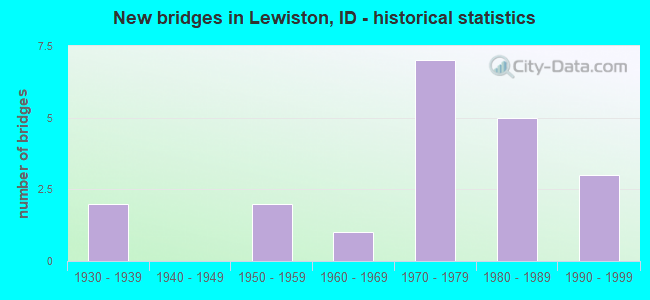
- New bridges - historical statistics
- 21930-1939
- 21950-1959
- 11960-1969
- 71970-1979
- 51980-1989
- 31990-1999

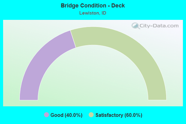
- Bridge Condition - Deck
- 40.0%Good
- 60.0%Satisfactory
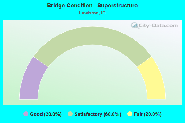
- Bridge Condition - Superstructure
- 20.0%Good
- 60.0%Satisfactory
- 20.0%Fair
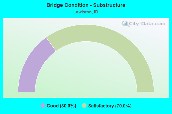
- Bridge Condition - Substructure
- 30.0%Good
- 70.0%Satisfactory
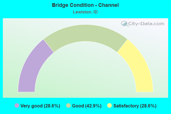
- Bridge Condition - Channel
- 28.6%Very good
- 42.9%Good
- 28.6%Satisfactory
Find on map >> Show street view
Structure Number: 1036, Location: IN LEWISTON AT STATE LINE (Lat: 46.420417, Lng: -117.033500), Route carried "on" structure: US 12, Year Built: 1939, Status: Open, Structure Length: 43.40m (142.39ft), Average Daily Traffic: 24,564 (year 2019), Truck Traffic: 4%, Average Future Daily Traffic: 28,101 (year 2039), Design Load: H 15, Features Intersected: US 12;SNAKE RIVER
Minimum Vertical Clearance: 5.31m (17.42ft), Kilometerpoint: 0.000, Lanes on structure: 4, Lanes under structure: 2, Base Highway Network: Yes (Inventory Route: US0, Subroute: 1), Owner: State Highway Agency, Approaching Roadway Width: 12.2m (40.0ft), Navigation Control: Yes ( Vertical Clearance: 12.8m (42.0ft), Horizontal Clearance: 48.8m (160.1ft)), Material/Design: Steel, Design/Construction: Movable - Lift, Number Of Spans In Main Unit: 3, Number Of Approach Spans: 14, Length of Maximum Span: 61.0m (200.1ft), Curb or Sidewalk Widths: Left: 2.0m (6.6ft), Right: 0.0m, Curb-To-Curb Width: 12.2m (40.0ft), Out-to-Out Width: 14.7m (48.2ft)
Condition: Deck: Satisfactory, Superstructure: Fair, Substructure: Satisfactory, Channel: Very good, Operating Rating: 31.8 metric tons, Method Used To Determine Operating Rating: Load Factor (LF), Inventory Rating: 19.1 metric tons, Method Used To Determine Inventory Rating: Load Factor (LF), Structural Evaluation: Meets minimum limits, Deck Geometry: High priority of replacement, Underclear: Meets minimum limits, Waterway Adequacy: Equal to present desirable criteria, Approach Roadway Alignment: High priority of corrective action, Length Of Structure Improvement: 43.40m (142.39ft), Designated Inspection Frequency: Every 24 months, Critical Feature Inspection Frequency: Every 24 months, Underwater Inspection Frequency: Every 60 months, Other Special Inspection Frequency: Every 24 months, Inspection Date: September 2021, Critical Feature Inspection Date: September 2021, Underwater Inspection Date: September 2021, Other Special Inspection Date: September 2021, Bridge Improvement Cost: $11,962,000, Roadway Improvement Cost: $2,392,000, Total Project Cost: $23,923,000 ( Estimate for 2014), Deck Structure Type: Concrete Cast-file-Place, Wearing Surface/Protective System: Wearing Surface: Latex Concrete
Find on map >> Show street view
Structure Number: 10375, Location: IN LEWISTON (Lat: 46.416944, Lng: -117.000167), Route carried "on" structure: US 12, Year Built: 1951, Status: Open, Structure Length: 41.21m (135.20ft), Average Daily Traffic: 29,000 (year 2019), Truck Traffic: 7%, Average Future Daily Traffic: 43,500 (year 2039), Design Load: HS 15, Features Intersected: CLEARWATER RIVER;BNRR
Minimum Vertical Clearance: 30+ m (98+ ft), Kilometerpoint: 3.122, Lanes on structure: 4, Lanes under structure: 2, Base Highway Network: Yes (Inventory Route: US0, Subroute: 2), Owner: State Highway Agency, Approaching Roadway Width: 15.2m (49.9ft), Skew: 20 degrees, Navigation Control: Yes ( Vertical Clearance: 4.0m (13.1ft), Horizontal Clearance: 32.0m (105.0ft)), Material/Design: Steel continuous, Design/Construction: Stringer/Multi-beam, Number Of Spans In Main Unit: 12, Length of Maximum Span: 34.4m (112.9ft), Curb or Sidewalk Widths: Left: 1.5m (4.9ft), Right: 1.5m (4.9ft), Curb-To-Curb Width: 14.6m (47.9ft), Out-to-Out Width: 18.9m (62.0ft)
Condition: Deck: Satisfactory, Superstructure: Satisfactory, Substructure: Satisfactory, Channel: Very good, Operating Rating: 44.5 metric tons, Method Used To Determine Operating Rating: Load Factor (LF), Inventory Rating: 26.3 metric tons, Method Used To Determine Inventory Rating: Load Factor (LF), Structural Evaluation: Equal to present minimum criteria, Deck Geometry: High priority of replacement, Underclear: Meets minimum limits, Waterway Adequacy: Superior to present desirable criteria, Approach Roadway Alignment: Equal to present desirable criteria, Length Of Structure Improvement: 42.89m (140.72ft), Designated Inspection Frequency: Every 24 months, Underwater Inspection Frequency: Every 60 months, Inspection Date: Febuary 2021, Underwater Inspection Date: September 2017, Bridge Improvement Cost: $14,394,000, Roadway Improvement Cost: $1,439,000, Total Project Cost: $21,590,000 ( Estimate for 2021), Deck Structure Type: Concrete Cast-file-Place, Wearing Surface/Protective System: Wearing Surface: Monolithic Concrete
Find on map >> Show street view
Structure Number: 1052, Location: AT LEWISTON NCL (Lat: 46.430019, Lng: -116.994700), Route carried "on" structure: Ramp US 95, Year Built: 1977, Status: Open, Structure Length: 11.58m (37.99ft), Average Daily Traffic: 5,600 (year 2019), Average Future Daily Traffic: 8,400 (year 2039), Design Load: HS 20, Features Intersected: US 95R SBL;LEWISTON IC
Minimum Vertical Clearance: 30+ m (98+ ft), Kilometerpoint: 0.285, Lanes on structure: 2, Lanes under structure: 3, Owner: State Highway Agency, Approaching Roadway Width: 11.0m (36.1ft), Skew: 4 degrees, Material/Design: Concrete continuous, Design/Construction: Box Beam or Girders - Single/Spread, Number Of Spans In Main Unit: 3, Length of Maximum Span: 43.3m (142.1ft), Curb-To-Curb Width: 11.8m (38.7ft), Out-to-Out Width: 12.7m (41.7ft)
Condition: Deck: Satisfactory, Superstructure: Fair, Substructure: Satisfactory, Operating Rating: 70.8 metric tons, Method Used To Determine Operating Rating: Load and Resistance Factor (LRFR), Inventory Rating: 51.7 metric tons, Method Used To Determine Inventory Rating: Load and Resistance Factor (LRFR), Structural Evaluation: Somewhat better than minimum adequacy, Deck Geometry: Superior to present desirable criteria, Underclear: Meets minimum limits, Approach Roadway Alignment: Equal to present desirable criteria, Designated Inspection Frequency: Every 24 months, Inspection Date: Febuary 2022, Deck Structure Type: Concrete Cast-file-Place, Wearing Surface/Protective System: Wearing Surface: Epoxy Overlay, Deck Protection: Cathodic Protection
Find on map >> Show street view
Structure Number: 18475, Location: 2.7 E. LEWISTON (Lat: 46.432500, Lng: -116.912500), Route carried "on" structure: US 95, Year Built: 1979, Status: Open, Structure Length: 0.76m (2.49ft), Average Daily Traffic: 13,500 (year 2019), Truck Traffic: 12%, Average Future Daily Traffic: 20,250 (year 2039), Design Load: HS 20, Features Intersected: HATWAI CREEK
Minimum Vertical Clearance: 30+ m (98+ ft), Kilometerpoint: 495.514, Lanes on structure: 5, Base Highway Network: Yes (Inventory Route: US0, Subroute: 1), Owner: State Highway Agency, Approaching Roadway Width: 29.3m (96.1ft), Skew: 10 degrees, Material/Design: Steel, Design/Construction: Culvert, Number Of Spans In Main Unit: 1, Length of Maximum Span: 7.6m (24.9ft), Curb-To-Curb Width: 29.3m (96.1ft), Out-to-Out Width: 48.8m (160.1ft)
Condition: Channel: Satisfactory, Culverts: Satisfactory, Structural Evaluation: Equal to present minimum criteria, Deck Geometry: Superior to present desirable criteria, Waterway Adequacy: Equal to present desirable criteria, Approach Roadway Alignment: Equal to present desirable criteria, Designated Inspection Frequency: Every 48 months, Inspection Date: July 2018
Find on map >> Show street view
Structure Number: 1848, Location: 3.0 N. LEWISTON (Lat: 46.473625, Lng: -117.036750), Route carried "on" structure: US 95, Year Built: 1980, Status: Open, Structure Length: 7.71m (25.30ft), Average Daily Traffic: 6,300 (year 2019), Truck Traffic: 11%, Average Future Daily Traffic: 9,450 (year 2039), Design Load: HS 20, Features Intersected: US 95 RAMP;WASHINGTON IC
Minimum Vertical Clearance: 30+ m (98+ ft), Kilometerpoint: 513.479, Lanes on structure: 4, Lanes under structure: 1, Base Highway Network: Yes (Inventory Route: US0, Subroute: 1), Owner: State Highway Agency, Approaching Roadway Width: 22.6m (74.1ft), Skew: 4 degrees, Material/Design: Concrete continuous, Design/Construction: Box Beam or Girders - Single/Spread, Number Of Spans In Main Unit: 3, Length of Maximum Span: 34.4m (112.9ft), Curb-To-Curb Width: 23.3m (76.4ft), Out-to-Out Width: 24.3m (79.7ft)
Condition: Deck: Satisfactory, Superstructure: Satisfactory, Substructure: Satisfactory, Operating Rating: 37.2 metric tons, Method Used To Determine Operating Rating: Load and Resistance Factor (LRFR), Inventory Rating: 28.1 metric tons, Method Used To Determine Inventory Rating: Load and Resistance Factor (LRFR), Structural Evaluation: Equal to present minimum criteria, Deck Geometry: Superior to present desirable criteria, Underclear: Meets minimum limits, Approach Roadway Alignment: Equal to present desirable criteria, Designated Inspection Frequency: Every 48 months, Inspection Date: Febuary 2022, Deck Structure Type: Concrete Cast-file-Place, Wearing Surface/Protective System: Wearing Surface: Epoxy Overlay, Deck Protection: Epoxy Coated Reinforcing
Find on map >> Show street view
Structure Number: 18805, Location: AT LEWISTON NCL (Lat: 46.430322, Lng: -116.994119), Route carried "on" structure: Ramp US 95, Year Built: 1977, Status: Open, Structure Length: 6.10m (20.01ft), Average Daily Traffic: 400 (year 2019), Truck Traffic: 28%, Average Future Daily Traffic: 600 (year 2039), Design Load: HS 20, Features Intersected: US 12 WB; LEWISTON IC
Minimum Vertical Clearance: 5.64m (18.50ft), Kilometerpoint: 0.270, Lanes on structure: 1, Lanes under structure: 2, Base Highway Network: Yes (Inventory Route: US0, Subroute: 8), Owner: State Highway Agency, Approaching Roadway Width: 6.7m (22.0ft), Skew: 2 degrees, Material/Design: Concrete continuous, Design/Construction: Box Beam or Girders - Single/Spread, Number Of Spans In Main Unit: 3, Length of Maximum Span: 29.6m (97.1ft), Curb-To-Curb Width: 7.7m (25.3ft), Out-to-Out Width: 8.4m (27.6ft)
Condition: Deck: Satisfactory, Superstructure: Satisfactory, Substructure: Satisfactory, Operating Rating: 48.1 metric tons, Method Used To Determine Operating Rating: Load and Resistance Factor (LRFR), Inventory Rating: 37.2 metric tons, Method Used To Determine Inventory Rating: Load and Resistance Factor (LRFR), Structural Evaluation: Equal to present minimum criteria, Deck Geometry: Better than present minimum criteria, Underclear: Equal to present minimum criteria, Approach Roadway Alignment: Equal to present minimum criteria, Designated Inspection Frequency: Every 48 months, Inspection Date: Febuary 2022, Deck Structure Type: Concrete Cast-file-Place, Wearing Surface/Protective System: Wearing Surface: Epoxy Overlay, Deck Protection: Cathodic Protection
Find on map >> Show street view
Structure Number: 21195, Location: IN LEWISTON (Lat: 46.396111, Lng: -117.036806), Route carried "on" structure: Ramp City street , Year Built: 1982, Status: Open, Structure Length: 16.76m (54.99ft), Average Daily Traffic: 5,550 (year 2019), Truck Traffic: 10%, Average Future Daily Traffic: 8,325 (year 2039), Design Load: HS 20, Features Intersected: RAMP;SNAKE RIVER;HIGH BR, Facility Carried by Structure: SNAKE RVR AVE RAMP
Minimum Vertical Clearance: 30+ m (98+ ft), Kilometerpoint: 0.183, Lanes on structure: 1, Owner: City or Municipal Highway Agency, Approaching Roadway Width: 8.5m (27.9ft), Material/Design: Prestressed concrete continuous, Design/Construction: Box Beam or Girders - Single/Spread, Number Of Spans In Main Unit: 5, Length of Maximum Span: 40.8m (133.9ft), Curb or Sidewalk Widths: Left: 2.0m (6.6ft), Right: 0.0m, Curb-To-Curb Width: 8.5m (27.9ft), Out-to-Out Width: 11.3m (37.1ft)
Condition: Deck: Good, Superstructure: Good, Substructure: Good, Operating Rating: 54.4 metric tons, Method Used To Determine Operating Rating: Assigned rating based on Load Factor Design (LFD) reported in metric tons, Inventory Rating: 32.7 metric tons, Method Used To Determine Inventory Rating: Assigned rating based on Load Factor Design (LFD) reported in metric tons, Structural Evaluation: Better than present minimum criteria, Deck Geometry: Superior to present desirable criteria, Approach Roadway Alignment: Equal to present desirable criteria, Designated Inspection Frequency: Every 24 months, Inspection Date: September 2020, Deck Structure Type: Concrete Cast-file-Place, Wearing Surface/Protective System: Wearing Surface: Bituminous
Find on map >> Show street view
Structure Number: 21291, Location: IN LEWISTON (Lat: 46.418056, Lng: -116.989222), Route carried "on" structure: City street 7124, Year Built: 1997, Status: Open, Structure Length: 1.55m (5.09ft), Average Daily Traffic: 6,000 (year 2019), Truck Traffic: 8%, Average Future Daily Traffic: 9,000 (year 2039), Features Intersected: LINDSAY CREEK
Minimum Vertical Clearance: 30+ m (98+ ft), Kilometerpoint: 0.958, Lanes on structure: 4, Owner: City or Municipal Highway Agency, Approaching Roadway Width: 14.6m (47.9ft), Material/Design: Steel, Design/Construction: Culvert, Number Of Spans In Main Unit: 4, Length of Maximum Span: 2.7m (8.9ft), Curb or Sidewalk Widths: Left: 1.7m (5.6ft), Right: 1.7m (5.6ft), Curb-To-Curb Width: 14.8m (48.6ft), Out-to-Out Width: 18.3m (60.0ft)
Condition: Channel: Good, Culverts: Satisfactory, Structural Evaluation: Equal to present minimum criteria, Deck Geometry: High priority of replacement, Waterway Adequacy: Better than present minimum criteria, Approach Roadway Alignment: Equal to present desirable criteria, Length Of Structure Improvement: 2.29m (7.51ft), Designated Inspection Frequency: Every 48 months, Inspection Date: September 2019, Bridge Improvement Cost: $767,000, Roadway Improvement Cost: $77,000, Total Project Cost: $1,151,000 ( Estimate for 2017)
Find on map >> Show street view
Structure Number: 2147, Location: IN LEWISTON;GUN CLUB RD. (Lat: 46.410833, Lng: -116.977306), Route carried "on" structure: City street 7334, Year Built: 1971, Status: Open, Structure Length: 0.67m (2.20ft), Average Daily Traffic: 5,000 (year 2019), Truck Traffic: 8%, Average Future Daily Traffic: 7,500 (year 2039), Design Load: HS 20, Features Intersected: LINDSAY CREEK
Minimum Vertical Clearance: 30+ m (98+ ft), Kilometerpoint: 3.085, Lanes on structure: 2, Owner: County Highway Agency, Approaching Roadway Width: 8.5m (27.9ft), Skew: 2 degrees, Material/Design: Steel, Design/Construction: Girder and Floorbeam System, Number Of Spans In Main Unit: 1, Length of Maximum Span: 6.4m (21.0ft), Curb-To-Curb Width: 7.9m (25.9ft), Out-to-Out Width: 8.1m (26.6ft)
Condition: Deck: Good, Superstructure: Satisfactory, Substructure: Good, Channel: Satisfactory, Operating Rating: 19.1 metric tons, Method Used To Determine Operating Rating: Load Factor (LF), Inventory Rating: 10.9 metric tons, Method Used To Determine Inventory Rating: Load Factor (LF), Structural Evaluation: High priority of replacement, Deck Geometry: High priority of corrective action, Waterway Adequacy: Better than present minimum criteria, Approach Roadway Alignment: Equal to present desirable criteria, Length Of Structure Improvement: 1.28m (4.20ft), Designated Inspection Frequency: Every 24 months, Inspection Date: September 2021, Bridge Improvement Cost: $333,000, Roadway Improvement Cost: $33,000, Total Project Cost: $499,000 ( Estimate for 2021), Deck Structure Type: Corrugated Steel, Wearing Surface/Protective System: Wearing Surface: Bituminous
Find on map >> Show street view
Structure Number: 21473, Location: 0.3 S. LEWISTON SCL (Lat: 46.358611, Lng: -116.921972), Route carried "on" structure: County highway 4755, Year Built: 1987, Status: Open, Structure Length: 1.10m (3.61ft), Average Daily Traffic: 2,500 (year 2019), Truck Traffic: 27%, Average Future Daily Traffic: 3,750 (year 2039), Design Load: HS 20, Features Intersected: TAMMANY CREEK
Minimum Vertical Clearance: 30+ m (98+ ft), Kilometerpoint: 17.891, Lanes on structure: 2, Owner: County Highway Agency, Approaching Roadway Width: 9.8m (32.2ft), Skew: 6 degrees, Material/Design: Concrete, Design/Construction: Frame, Number Of Spans In Main Unit: 2, Length of Maximum Span: 5.2m (17.1ft), Curb-To-Curb Width: 10.4m (34.1ft), Out-to-Out Width: 14.8m (48.6ft)
Condition: Deck: Good, Superstructure: Good, Substructure: Satisfactory, Channel: Good, Operating Rating: 34.5 metric tons, Method Used To Determine Operating Rating: Load Factor (LF), Inventory Rating: 20.0 metric tons, Method Used To Determine Inventory Rating: Load Factor (LF), Structural Evaluation: Somewhat better than minimum adequacy, Deck Geometry: Somewhat better than minimum adequacy, Waterway Adequacy: Better than present minimum criteria, Approach Roadway Alignment: Equal to present desirable criteria, Designated Inspection Frequency: Every 24 months, Inspection Date: September 2021, Deck Structure Type: Concrete Cast-file-Place, Wearing Surface/Protective System: Wearing Surface: Bituminous
Find on map >> Show street view
Structure Number: 2149, Location: IN LEWISTON (Lat: 46.392111, Lng: -117.024889), Route carried "on" structure: City street 7134, Year Built: 1999, Status: Open, Structure Length: 4.05m (13.29ft), Average Daily Traffic: 4,000 (year 2019), Average Future Daily Traffic: 6,000 (year 2039), Design Load: HS 25 or greater, Features Intersected: BRYDEN CANYON ROAD
Minimum Vertical Clearance: 5.49m (18.01ft), Kilometerpoint: 161.043, Lanes on structure: 4, Lanes under structure: 4, Owner: City or Municipal Highway Agency, Approaching Roadway Width: 17.7m (58.1ft), Skew: 1 degrees, Material/Design: Prestressed concrete, Design/Construction: Box Beam or Girders - Single/Spread, Number Of Spans In Main Unit: 1, Length of Maximum Span: 39.3m (128.9ft), Curb or Sidewalk Widths: Left: 2.0m (6.6ft), Right: 2.0m (6.6ft), Curb-To-Curb Width: 17.8m (58.4ft), Out-to-Out Width: 22.3m (73.2ft)
Condition: Deck: Good, Superstructure: Satisfactory, Substructure: Good, Operating Rating: 78.0 metric tons, Method Used To Determine Operating Rating: Load and Resistance Factor (LRFR), Inventory Rating: 57.2 metric tons, Method Used To Determine Inventory Rating: Load and Resistance Factor (LRFR), Structural Evaluation: Equal to present minimum criteria, Deck Geometry: Somewhat better than minimum adequacy, Underclear: Somewhat better than minimum adequacy, Approach Roadway Alignment: Equal to present desirable criteria, Designated Inspection Frequency: Every 48 months, Inspection Date: July 2020, Deck Structure Type: Concrete Cast-file-Place, Wearing Surface/Protective System: Wearing Surface: Monolithic Concrete, Deck Protection: Other Coated Reinforcing
Find on map >> Show street view
Structure Number: 2991, Location: 2.2 N. 3.0 E. LEWISTON (Lat: 46.445667, Lng: -116.939361), Route carried "on" structure: County highway , Year Built: 1968, Status: Open, Structure Length: 1.58m (5.18ft), Average Daily Traffic: 650 (year 2019), Truck Traffic: 10%, Average Future Daily Traffic: 975 (year 2039), Design Load: HS 20, Features Intersected: HATWAI CREEK, Facility Carried by Structure: CENTRAL GRADE ROAD
Minimum Vertical Clearance: 30+ m (98+ ft), Kilometerpoint: 8.822, Lanes on structure: 2, Owner: County Highway Agency, Approaching Roadway Width: 6.7m (22.0ft), Material/Design: Steel, Design/Construction: Girder and Floorbeam System, Number Of Spans In Main Unit: 2, Length of Maximum Span: 7.9m (25.9ft), Curb-To-Curb Width: 8.4m (27.6ft), Out-to-Out Width: 8.5m (27.9ft)
Condition: Deck: Satisfactory, Superstructure: Satisfactory, Substructure: Satisfactory, Channel: Good, Operating Rating: 38.1 metric tons, Method Used To Determine Operating Rating: Allowable Stress (AS), Inventory Rating: 24.5 metric tons, Method Used To Determine Inventory Rating: Allowable Stress (AS), Structural Evaluation: Equal to present minimum criteria, Deck Geometry: Somewhat better than minimum adequacy, Waterway Adequacy: Better than present minimum criteria, Approach Roadway Alignment: Equal to present desirable criteria, Designated Inspection Frequency: Every 24 months, Inspection Date: May 2021, Deck Structure Type: Corrugated Steel, Wearing Surface/Protective System: Wearing Surface: Bituminous
Find on map >> Show street view
Structure Number: 1036, Location: IN LEWISTON AT STATE LINE (Lat: 46.420417, Lng: -117.033500), Route carried "under" structure: US 12, Year Built: 1939, Structure Length: 0. m, Average Daily Traffic: 8,200 (year 2018), Truck Traffic: 9%, Features Intersected: US 12;SNAKE RIVER
Minimum Vertical Clearance: 4.93m (16.17ft), Kilometerpoint: 0.647, Lanes on structure: 4, Lanes under structure: 2, Material/Design: Steel, Design/Construction: Movable - Lift, Length of Maximum Span: 61.0m (200.1ft)
Find on map >> Show street view
Structure Number: 10375, Location: IN LEWISTON (Lat: 46.416944, Lng: -117.000167), Route carried "under" structure: City street , Year Built: 1951, Structure Length: 0. m, Average Daily Traffic: 30 (year 2018), Truck Traffic: 2%, Features Intersected: CLEARWATER RIVER;BNRR, Facility Carried by Structure: US 12
Minimum Vertical Clearance: 6.64m (21.78ft), Kilometerpoint: 161.451, Lanes on structure: 4, Lanes under structure: 2, Material/Design: Steel continuous, Design/Construction: Stringer/Multi-beam, Length of Maximum Span: 34.4m (112.9ft)
Find on map >> Show street view
Structure Number: 1052, Location: AT LEWISTON NCL (Lat: 46.430019, Lng: -116.994700), Route carried "under" structure: Ramp US 95, Year Built: 1977, Structure Length: 0. m, Average Daily Traffic: 400 (year 2018), Truck Traffic: 28%, Features Intersected: US 95R SBL;LEWISTON IC
Minimum Vertical Clearance: 5.64m (18.50ft), Kilometerpoint: 502.468, Lanes on structure: 2, Lanes under structure: 1, Material/Design: Concrete continuous, Design/Construction: Box Beam or Girders - Single/Spread, Length of Maximum Span: 43.3m (142.1ft)
Find on map >> Show street view
Structure Number: 1052, Location: AT LEWISTON NCL (Lat: 46.430019, Lng: -116.994700), Route carried "under" structure: US 12, Year Built: 1977, Structure Length: 0. m, Average Daily Traffic: 5,200 (year 2018), Truck Traffic: 6%, Features Intersected: US 95R SBL;LEWISTON IC, Facility Carried by Structure: US 95 RAMP NBL
Minimum Vertical Clearance: 5.31m (17.42ft), Kilometerpoint: 5.039, Lanes on structure: 2, Lanes under structure: 2, Material/Design: Concrete continuous, Design/Construction: Box Beam or Girders - Single/Spread, Length of Maximum Span: 43.3m (142.1ft)
Find on map >> Show street view
Structure Number: 1848, Location: 3.0 N. LEWISTON (Lat: 46.473625, Lng: -117.036750), Route carried "under" structure: Ramp US 95, Year Built: 1980, Structure Length: 0. m, Average Daily Traffic: 2,200 (year 2018), Features Intersected: US 95 RAMP;WASHINGTON IC
Minimum Vertical Clearance: 5.49m (18.01ft), Kilometerpoint: 0.710, Lanes on structure: 4, Lanes under structure: 1, Material/Design: Concrete continuous, Design/Construction: Box Beam or Girders - Single/Spread, Length of Maximum Span: 34.4m (112.9ft)
Find on map >> Show street view
Structure Number: 18805, Location: AT LEWISTON NCL (Lat: 46.430322, Lng: -116.994119), Route carried "under" structure: Ramp US 12, Year Built: 1977, Structure Length: 0. m, Average Daily Traffic: 7,800 (year 2018), Truck Traffic: 8%, Features Intersected: US 12 WB; LEWISTON IC, Facility Carried by Structure: US 95RAMP SB
Minimum Vertical Clearance: 5.31m (17.42ft), Kilometerpoint: 5.039, Lanes on structure: 1, Lanes under structure: 2, Material/Design: Concrete continuous, Design/Construction: Box Beam or Girders - Single/Spread, Length of Maximum Span: 29.6m (97.1ft)
Find on map >> Show street view
Structure Number: 2149, Location: IN LEWISTON (Lat: 46.392111, Lng: -117.024889), Route carried "under" structure: City street 7344, Year Built: 1999, Structure Length: 0. m, Average Daily Traffic: 18,000 (year 2018), Features Intersected: BRYDEN CANYON ROAD, Facility Carried by Structure: SMA 7134;8TH ST.
Minimum Vertical Clearance: 6.34m (20.80ft), Kilometerpoint: 1.374, Lanes on structure: 4, Lanes under structure: 4, Material/Design: Prestressed concrete, Design/Construction: Box Beam or Girders - Single/Spread, Length of Maximum Span: 39.3m (128.9ft)
Find on map >> Show street view
Structure Number: 21495, Location: IN LEWISTON;BRYDEN EXT (Lat: 46.396667, Lng: -117.043222), Route carried "under" structure: City street 7014, Year Built: 1982, Structure Length: 0. m, Average Daily Traffic: 15,500 (year 2018), Features Intersected: SNAKE R;HIGH/SOUTHWAY BR, Facility Carried by Structure: SMA7344;BRYDEN CYN
Minimum Vertical Clearance: 7.62m (25.00ft), Kilometerpoint: 3.014, Lanes on structure: 4, Lanes under structure: 2, Material/Design: Prestressed concrete continuous, Design/Construction: Box Beam or Girders - Single/Spread, Length of Maximum Span: 185.9m (609.9ft)