Bridge Statistics for Lewisburg, West Virginia (WV)
Condition, Traffic, Stress, Structural Evaluation, Project Costs
- National Bridge Inventory (NBI) Statistics
- 20Number of bridges
- 200ft / 61.4mTotal length
- $3,902,000Total costs
- 128,562Total average daily traffic
- 22,865Total average daily truck traffic
- National Bridge Inventory (NBI) Registered Bridges for Lewisburg
- No street view available for this location
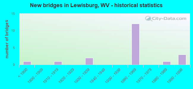
- New bridges - historical statistics
- 1Before 1900
- 11910-1919
- 21930-1939
- 121960-1969
- 11980-1989
- 31990-1999


- Bridge Condition - Deck
- 9.1%Very good
- 27.3%Good
- 36.4%Satisfactory
- 27.3%Fair

- Bridge Condition - Superstructure
- 45.5%Good
- 9.1%Satisfactory
- 36.4%Fair
- 9.1%Poor

- Bridge Condition - Substructure
- 9.1%Very good
- 9.1%Good
- 45.5%Satisfactory
- 27.3%Fair
- 9.1%Poor

- Bridge Condition - Channel
- 25.0%Very good
- 75.0%Good
Find on map >> Show street view
Structure Number: 13A013, Location: 0.04 Miles E. of US 60 (Lat: 37.804019, Lng: -80.450231), Route carried "on" structure: County highway 6057, Year Built: 1990, Status: Open, Structure Length: 1.99m (6.53ft), Average Daily Traffic: 100 (year 2020), Truck Traffic: 10%, Average Future Daily Traffic: 128 (year 2040), Design Load: HS 20, Features Intersected: US 60, Facility Carried by Structure: COUNTY ROUTE 60/57
Minimum Vertical Clearance: 30+ m (98+ ft), Kilometerpoint: 0.064, Lanes on structure: 1, Lanes under structure: 2, Owner: State Highway Agency, Approaching Roadway Width: 4.3m (14.1ft), Material/Design: Wood or Timber, Design/Construction: Slab, Number Of Spans In Main Unit: 1, Length of Maximum Span: 18.7m (61.4ft), Curb-To-Curb Width: 4.3m (14.1ft), Out-to-Out Width: 5.0m (16.4ft)
Condition: Deck: Good, Superstructure: Good, Substructure: Satisfactory, Operating Rating: 88.9 metric tons, Method Used To Determine Operating Rating: Allowable Stress (AS), Inventory Rating: 78.9 metric tons, Method Used To Determine Inventory Rating: Allowable Stress (AS), Structural Evaluation: Equal to present minimum criteria, Deck Geometry: Equal to present minimum criteria, Underclear: Somewhat better than minimum adequacy, Approach Roadway Alignment: Meets minimum limits, Designated Inspection Frequency: Every 24 months, Other Special Inspection Frequency: Every 3 months, Inspection Date: June 2021, Other Special Inspection Date: December 2021, Deck Structure Type: Wood or Timber, Wearing Surface/Protective System: Wearing Surface: Bituminous, Deck Protection: Other
Find on map >> Show street view
Structure Number: 13A082, Location: 0.18 Miles N. of CR 32/1 (Lat: 37.819719, Lng: -80.436281), Route carried "on" structure: County highway 3200, Year Built: 1968, Status: Open, Structure Length: 7.59m (24.90ft), Average Daily Traffic: 1,053 (year 2019), Truck Traffic: 10%, Average Future Daily Traffic: 1,348 (year 2039), Design Load: HS 20, Features Intersected: I64 EBL & WBL, Facility Carried by Structure: COUNTY ROUTE 32
Minimum Vertical Clearance: 30+ m (98+ ft), Kilometerpoint: 2.317, Lanes on structure: 2, Lanes under structure: 4, Owner: State Highway Agency, Approaching Roadway Width: 4.9m (16.1ft), Material/Design: Steel continuous, Design/Construction: Stringer/Multi-beam, Number Of Spans In Main Unit: 2, Number Of Approach Spans: 2, Length of Maximum Span: 24.8m (81.4ft), Curb or Sidewalk Widths: Left: 0.3m (1.0ft), Right: 0.3m (1.0ft), Curb-To-Curb Width: 8.1m (26.6ft), Out-to-Out Width: 9.3m (30.5ft)
Condition: Deck: Good, Superstructure: Good, Substructure: Fair, Operating Rating: 64.4 metric tons, Method Used To Determine Operating Rating: Load Factor (LF), Inventory Rating: 39.0 metric tons, Method Used To Determine Inventory Rating: Load Factor (LF), Structural Evaluation: Somewhat better than minimum adequacy, Deck Geometry: Meets minimum limits, Underclear: Somewhat better than minimum adequacy, Approach Roadway Alignment: Equal to present minimum criteria, Length Of Structure Improvement: 7.59m (24.90ft), Designated Inspection Frequency: Every 24 months, Inspection Date: July 2020, Bridge Improvement Cost: $231,000, Roadway Improvement Cost: $10,000, Total Project Cost: $241,000 ( Estimate for 2020), Deck Structure Type: Concrete Cast-file-Place, Wearing Surface/Protective System: Wearing Surface: Monolithic Concrete
Find on map >> Show street view
Structure Number: 13A114, Location: 0.05 Miles E. of CR 38 (Lat: 37.782069, Lng: -80.397450), Route carried "on" structure: US 6000, Year Built: 1994, Status: Open, Structure Length: 16.31m (53.51ft), Average Daily Traffic: 6,777 (year 2019), Truck Traffic: 8%, Average Future Daily Traffic: 8,675 (year 2039), Design Load: HS 25 or greater, Features Intersected: GREENBRIER RIVER, Facility Carried by Structure: US 60
Minimum Vertical Clearance: 30+ m (98+ ft), Kilometerpoint: 56.214, Lanes on structure: 2, Owner: State Highway Agency, Approaching Roadway Width: 7.3m (24.0ft), Material/Design: Steel continuous, Design/Construction: Stringer/Multi-beam, Number Of Spans In Main Unit: 4, Number Of Approach Spans: 2, Length of Maximum Span: 29.0m (95.1ft), Curb or Sidewalk Widths: Left: 0.0m, Right: 1.7m (5.6ft), Curb-To-Curb Width: 9.0m (29.5ft), Out-to-Out Width: 11.5m (37.7ft)
Condition: Deck: Very good, Superstructure: Satisfactory, Substructure: Very good, Channel: Good, Operating Rating: 88.9 metric tons, Method Used To Determine Operating Rating: Load Factor (LF), Inventory Rating: 72.6 metric tons, Method Used To Determine Inventory Rating: Load Factor (LF), Structural Evaluation: Equal to present minimum criteria, Deck Geometry: Meets minimum limits, Waterway Adequacy: Equal to present desirable criteria, Approach Roadway Alignment: Better than present minimum criteria, Designated Inspection Frequency: Every 48 months, Inspection Date: September 2020, Deck Structure Type: Concrete Cast-file-Place, Wearing Surface/Protective System: Wearing Surface: Monolithic Concrete, Deck Protection: Epoxy Coated Reinforcing
Find on map >> Show street view
Structure Number: 13A125, Location: 1.04 Miles S. of US 60 (Lat: 37.842219, Lng: -80.470769), Route carried "on" structure: County highway 6012, Year Built: 1968, Status: Open, Structure Length: 7.79m (25.56ft), Average Daily Traffic: 104 (year 2019), Truck Traffic: 10%, Average Future Daily Traffic: 133 (year 2039), Design Load: HS 20, Features Intersected: I-64 EBL & WBL, Facility Carried by Structure: COUNTY ROUTE 60/12
Minimum Vertical Clearance: 30+ m (98+ ft), Kilometerpoint: 2.189, Lanes on structure: 2, Lanes under structure: 4, Owner: State Highway Agency, Approaching Roadway Width: 3.0m (9.8ft), Skew: 1 degrees, Material/Design: Steel continuous, Design/Construction: Stringer/Multi-beam, Number Of Spans In Main Unit: 2, Length of Maximum Span: 38.1m (125.0ft), Curb-To-Curb Width: 8.5m (27.9ft), Out-to-Out Width: 9.8m (32.2ft)
Condition: Deck: Satisfactory, Superstructure: Good, Substructure: Satisfactory, Operating Rating: 67.1 metric tons, Method Used To Determine Operating Rating: Load Factor (LF), Inventory Rating: 40.8 metric tons, Method Used To Determine Inventory Rating: Load Factor (LF), Structural Evaluation: Equal to present minimum criteria, Deck Geometry: Equal to present minimum criteria, Underclear: Somewhat better than minimum adequacy, Approach Roadway Alignment: Equal to present desirable criteria, Length Of Structure Improvement: 7.80m (25.59ft), Designated Inspection Frequency: Every 24 months, Inspection Date: June 2020, Bridge Improvement Cost: $251,000, Total Project Cost: $251,000 ( Estimate for 2018), Deck Structure Type: Concrete Cast-file-Place, Wearing Surface/Protective System: Wearing Surface: Monolithic Concrete
Find on map >> Show street view
Structure Number: 13A143, Location: 0.19 Miles S. of US 60 (Lat: 37.778269, Lng: -80.394431), Route carried "on" structure: State highway 6300, Year Built: 1982, Status: Posted for load, Structure Length: 3.10m (10.17ft), Average Daily Traffic: 2,993 (year 2019), Truck Traffic: 14%, Average Future Daily Traffic: 3,831 (year 2039), Design Load: HS 20, Features Intersected: HOWARDS CREEK, Facility Carried by Structure: WV 63
Minimum Vertical Clearance: 30+ m (98+ ft), Kilometerpoint: 34.376, Lanes on structure: 1, Base Highway Network: Yes, Owner: State Highway Agency, Approaching Roadway Width: 6.7m (22.0ft), Material/Design: Steel, Design/Construction: Girder and Floorbeam System, Number Of Spans In Main Unit: 1, Number Of Approach Spans: 1, Length of Maximum Span: 23.8m (78.1ft), Curb or Sidewalk Widths: Left: 0.2m (0.7ft), Right: 0.2m (0.7ft), Curb-To-Curb Width: 4.6m (15.1ft), Out-to-Out Width: 4.9m (16.1ft)
Condition: Deck: Fair, Superstructure: Poor, Substructure: Fair, Channel: Good, Operating Rating: 49.0 metric tons, Method Used To Determine Operating Rating: Load Factor (LF), Inventory Rating: 29.9 metric tons, Method Used To Determine Inventory Rating: Load Factor (LF), Structural Evaluation: Meets minimum limits, Deck Geometry: High priority of replacement, Waterway Adequacy: Somewhat better than minimum adequacy, Approach Roadway Alignment: High priority of corrective action, Length Of Structure Improvement: 3.84m (12.60ft), Designated Inspection Frequency: Every 24 months, Critical Feature Inspection Frequency: Every 12 months, Other Special Inspection Frequency: Every 12 months, Inspection Date: July 2021, Critical Feature Inspection Date: July 2021, Other Special Inspection Date: July 2021, Bridge Improvement Cost: $976,000, Roadway Improvement Cost: $627,000, Total Project Cost: $1,603,000 ( Estimate for 2021), Deck Structure Type: Wood or Timber, Wearing Surface/Protective System: Wearing Surface: Bituminous, Membrane: Built-up, Deck Protection: Other
Find on map >> Show street view
Structure Number: 13A146, Location: 3.52 Miles W. of US 219 (Lat: 37.845669, Lng: -80.479631), Route carried "on" structure: Interstate 6400, Year Built: 1968, Status: Open, Structure Length: 3.78m (12.40ft), Average Daily Traffic: 6,495 (year 2019), Truck Traffic: 22%, Average Future Daily Traffic: 9,418 (year 2039), Design Load: HS 20+Mod, Features Intersected: US 60, Facility Carried by Structure: I-64 EBL
Minimum Vertical Clearance: 30+ m (98+ ft), Kilometerpoint: 266.942, Lanes on structure: 2, Lanes under structure: 2, Base Highway Network: Yes, Owner: State Highway Agency, Approaching Roadway Width: 12.2m (40.0ft), Material/Design: Steel continuous, Design/Construction: Stringer/Multi-beam, Number Of Spans In Main Unit: 1, Number Of Approach Spans: 2, Length of Maximum Span: 15.2m (49.9ft), Curb-To-Curb Width: 12.3m (40.4ft), Out-to-Out Width: 13.6m (44.6ft)
Condition: Deck: Fair, Superstructure: Fair, Substructure: Fair, Operating Rating: 72.6 metric tons, Method Used To Determine Operating Rating: Load Factor (LF), Inventory Rating: 43.5 metric tons, Method Used To Determine Inventory Rating: Load Factor (LF), Structural Evaluation: Somewhat better than minimum adequacy, Deck Geometry: Better than present minimum criteria, Underclear: Somewhat better than minimum adequacy, Approach Roadway Alignment: Equal to present desirable criteria, Designated Inspection Frequency: Every 24 months, Inspection Date: November 2020, Deck Structure Type: Concrete Cast-file-Place, Wearing Surface/Protective System: Wearing Surface: Latex Concrete
Find on map >> Show street view
Structure Number: 13A147, Location: 3.52 Miles W. of US 219 (Lat: 37.845981, Lng: -80.479489), Route carried "on" structure: Interstate 6400, Year Built: 1968, Status: Open, Structure Length: 3.78m (12.40ft), Average Daily Traffic: 15,099 (year 2019), Truck Traffic: 28%, Average Future Daily Traffic: 21,894 (year 2039), Design Load: HS 20+Mod, Features Intersected: US 60, Facility Carried by Structure: I-64 WBL
Minimum Vertical Clearance: 30+ m (98+ ft), Kilometerpoint: 266.942, Lanes on structure: 2, Lanes under structure: 2, Base Highway Network: Yes, Owner: State Highway Agency, Approaching Roadway Width: 12.2m (40.0ft), Material/Design: Steel continuous, Design/Construction: Stringer/Multi-beam, Number Of Spans In Main Unit: 1, Number Of Approach Spans: 2, Length of Maximum Span: 15.2m (49.9ft), Curb-To-Curb Width: 12.3m (40.4ft), Out-to-Out Width: 13.6m (44.6ft)
Condition: Deck: Satisfactory, Superstructure: Fair, Substructure: Satisfactory, Operating Rating: 65.3 metric tons, Method Used To Determine Operating Rating: Load Factor (LF), Inventory Rating: 39.9 metric tons, Method Used To Determine Inventory Rating: Load Factor (LF), Structural Evaluation: Somewhat better than minimum adequacy, Deck Geometry: Better than present minimum criteria, Underclear: Better than present minimum criteria, Approach Roadway Alignment: Equal to present desirable criteria, Designated Inspection Frequency: Every 24 months, Inspection Date: November 2020, Deck Structure Type: Concrete Cast-file-Place, Wearing Surface/Protective System: Wearing Surface: Latex Concrete
Find on map >> Show street view
Structure Number: 13A148, Location: 0.00 Miles E. of US 219 (Lat: 37.816531, Lng: -80.428000), Route carried "on" structure: Interstate 6400, Year Built: 1967, Status: Open, Structure Length: 5.40m (17.72ft), Average Daily Traffic: 12,760 (year 2020), Truck Traffic: 28%, Average Future Daily Traffic: 16,333 (year 2040), Design Load: HS 20+Mod, Features Intersected: US 219, Facility Carried by Structure: I-64 EBL
Minimum Vertical Clearance: 30+ m (98+ ft), Kilometerpoint: 272.591, Lanes on structure: 2, Lanes under structure: 3, Base Highway Network: Yes, Owner: State Highway Agency, Approaching Roadway Width: 12.5m (41.0ft), Material/Design: Steel continuous, Design/Construction: Stringer/Multi-beam, Number Of Spans In Main Unit: 1, Number Of Approach Spans: 2, Length of Maximum Span: 22.0m (72.2ft), Curb-To-Curb Width: 11.7m (38.4ft), Out-to-Out Width: 13.0m (42.7ft)
Condition: Deck: Satisfactory, Superstructure: Good, Substructure: Satisfactory, Operating Rating: 68.0 metric tons, Method Used To Determine Operating Rating: Load Factor (LF), Inventory Rating: 40.8 metric tons, Method Used To Determine Inventory Rating: Load Factor (LF), Structural Evaluation: Equal to present minimum criteria, Deck Geometry: Somewhat better than minimum adequacy, Underclear: Meets minimum limits, Approach Roadway Alignment: Equal to present desirable criteria, Designated Inspection Frequency: Every 24 months, Inspection Date: November 2020, Deck Structure Type: Concrete Cast-file-Place, Wearing Surface/Protective System: Wearing Surface: Monolithic Concrete
Find on map >> Show street view
Structure Number: 13A149, Location: 0.00 Miles E. of US 219 (Lat: 37.816711, Lng: -80.427800), Route carried "on" structure: Interstate 6400, Year Built: 1967, Status: Open, Structure Length: 4.89m (16.04ft), Average Daily Traffic: 12,760 (year 2019), Truck Traffic: 28%, Average Future Daily Traffic: 16,333 (year 2039), Design Load: HS 20+Mod, Features Intersected: US 219, Facility Carried by Structure: I-64 WBL
Minimum Vertical Clearance: 30+ m (98+ ft), Kilometerpoint: 272.591, Lanes on structure: 2, Lanes under structure: 3, Base Highway Network: Yes, Owner: State Highway Agency, Approaching Roadway Width: 12.5m (41.0ft), Skew: 1 degrees, Material/Design: Steel continuous, Design/Construction: Stringer/Multi-beam, Number Of Spans In Main Unit: 1, Number Of Approach Spans: 2, Length of Maximum Span: 22.0m (72.2ft), Curb-To-Curb Width: 11.7m (38.4ft), Out-to-Out Width: 13.0m (42.7ft)
Condition: Deck: Satisfactory, Superstructure: Fair, Substructure: Satisfactory, Operating Rating: 75.3 metric tons, Method Used To Determine Operating Rating: Load Factor (LF), Inventory Rating: 45.4 metric tons, Method Used To Determine Inventory Rating: Load Factor (LF), Structural Evaluation: Somewhat better than minimum adequacy, Deck Geometry: Equal to present minimum criteria, Underclear: Somewhat better than minimum adequacy, Approach Roadway Alignment: Equal to present desirable criteria, Designated Inspection Frequency: Every 24 months, Inspection Date: November 2020, Deck Structure Type: Concrete Cast-file-Place, Wearing Surface/Protective System: Wearing Surface: Latex Concrete
Find on map >> Show street view
Structure Number: 13A185, Location: 0.19 Miles W. of CR 38 (Lat: 37.784469, Lng: -80.401450), Route carried "on" structure: US 6000, Year Built: 1930, Status: Open, Structure Length: 4.22m (13.85ft), Average Daily Traffic: 6,389 (year 2019), Truck Traffic: 8%, Average Future Daily Traffic: 8,178 (year 2039), Features Intersected: PRIVATE ROAD, Facility Carried by Structure: US 60
Minimum Vertical Clearance: 30+ m (98+ ft), Kilometerpoint: 55.828, Lanes on structure: 2, Owner: State Highway Agency, Approaching Roadway Width: 7.3m (24.0ft), Material/Design: Concrete, Design/Construction: Stringer/Multi-beam, Number Of Spans In Main Unit: 1, Number Of Approach Spans: 2, Length of Maximum Span: 14.4m (47.2ft), Curb or Sidewalk Widths: Left: 0.2m (0.7ft), Right: 0.2m (0.7ft), Curb-To-Curb Width: 7.4m (24.3ft), Out-to-Out Width: 8.3m (27.2ft)
Condition: Deck: Fair, Superstructure: Fair, Substructure: Poor, Operating Rating: 60.8 metric tons, Method Used To Determine Operating Rating: Load Factor (LF), Inventory Rating: 37.2 metric tons, Method Used To Determine Inventory Rating: Load Factor (LF), Structural Evaluation: Meets minimum limits, Deck Geometry: High priority of replacement, Approach Roadway Alignment: Equal to present desirable criteria, Length Of Structure Improvement: 4.24m (13.91ft), Designated Inspection Frequency: Every 24 months, Inspection Date: July 2020, Bridge Improvement Cost: $755,000, Roadway Improvement Cost: $10,000, Total Project Cost: $765,000 ( Estimate for 2020), Deck Structure Type: Concrete Cast-file-Place, Wearing Surface/Protective System: Wearing Surface: Bituminous
Find on map >> Show street view
Structure Number: 13A214, Location: 0.10 Miles E. of CR 60/17 (Lat: 37.787019, Lng: -80.404289), Route carried "on" structure: US 6000, Year Built: 1930, Status: Open, Structure Length: 0.73m (2.40ft), Average Daily Traffic: 5,779 (year 2019), Truck Traffic: 8%, Average Future Daily Traffic: 7,397 (year 2039), Features Intersected: PRICE RUN, Facility Carried by Structure: US 60
Minimum Vertical Clearance: 30+ m (98+ ft), Kilometerpoint: 55.200, Lanes on structure: 2, Owner: State Highway Agency, Approaching Roadway Width: 11.6m (38.1ft), Skew: 3 degrees, Material/Design: Concrete, Design/Construction: Culvert, Number Of Spans In Main Unit: 1, Length of Maximum Span: 7.3m (24.0ft)
Condition: Channel: Very good, Culverts: Fair, Operating Rating: 63.5 metric tons, Method Used To Determine Operating Rating: Field evaluation and documented engineering judgment, Inventory Rating: 29.0 metric tons, Method Used To Determine Inventory Rating: Field evaluation and documented engineering judgment, Structural Evaluation: Somewhat better than minimum adequacy, Waterway Adequacy: Superior to present desirable criteria, Approach Roadway Alignment: Equal to present desirable criteria, Length Of Structure Improvement: 1.07m (3.51ft), Designated Inspection Frequency: Every 24 months, Inspection Date: April 2021, Bridge Improvement Cost: $200,000, Roadway Improvement Cost: $199,000, Total Project Cost: $528,000 ( Estimate for 2021)
Find on map >> Show street view
Structure Number: 13A237, Location: 0.90 Miles S. of CR 60/11 (Lat: 37.832550, Lng: -80.504681), Route carried "on" structure: County highway 4000, Year Built: 1884, Year Reconstructed: 2000, Status: Open, Structure Length: 1.79m (5.87ft), Average Daily Traffic: 155 (year 2019), Truck Traffic: 10%, Average Future Daily Traffic: 198 (year 2039), Features Intersected: MILLIGAN CREEK, Facility Carried by Structure: COUNTY ROUTE 40
Minimum Vertical Clearance: 3.25m (10.66ft), Kilometerpoint: 21.581, Lanes on structure: 1, Owner: State Highway Agency, Approaching Roadway Width: 3.7m (12.1ft), Material/Design: Steel, Design/Construction: Stringer/Multi-beam, Number Of Spans In Main Unit: 1, Length of Maximum Span: 16.3m (53.5ft), Curb-To-Curb Width: 2.7m (8.9ft), Out-to-Out Width: 3.1m (10.2ft)
Condition: Deck: Good, Superstructure: Good, Substructure: Good, Channel: Good, Operating Rating: 88.9 metric tons, Method Used To Determine Operating Rating: Load Factor (LF), Inventory Rating: 86.2 metric tons, Method Used To Determine Inventory Rating: Load Factor (LF), Structural Evaluation: Better than present minimum criteria, Deck Geometry: High priority of replacement, Waterway Adequacy: Superior to present desirable criteria, Approach Roadway Alignment: High priority of corrective action, Length Of Structure Improvement: 1.83m (6.00ft), Designated Inspection Frequency: Every 24 months, Inspection Date: July 2020, Bridge Improvement Cost: $256,000, Roadway Improvement Cost: $248,000, Total Project Cost: $514,000 ( Estimate for 2020), Deck Structure Type: Wood or Timber, Wearing Surface/Protective System: Wearing Surface: Wood or Timber
Find on map >> Show street view
Structure Number: 13A013, Location: 0.04 Miles E. of US 60 (Lat: 37.804019, Lng: -80.450236), Route carried "under" structure: US 6000, Year Built: 1990, Structure Length: 0. m, Average Daily Traffic: 3,500 (year 0012), Truck Traffic: 8%, Features Intersected: US 60, Facility Carried by Structure: COUNTY ROUTE 60/57
Minimum Vertical Clearance: 4.65m (15.26ft), Kilometerpoint: 50.807, Lanes on structure: 1, Lanes under structure: 2, Length of Maximum Span: 18.7m (61.4ft)
Find on map >> Show street view
Structure Number: 13A082, Location: 0.18 Miles N. of CR 32/1 (Lat: 37.819733, Lng: -80.436278), Route carried "under" structure: Interstate 6400, Year Built: 1968, Structure Length: 0. m, Average Daily Traffic: 11,000 (year 0011), Truck Traffic: 22%, Features Intersected: I64 EBL & WBL, Facility Carried by Structure: COUNTY ROUTE 32
Minimum Vertical Clearance: 5.13m (16.83ft), Kilometerpoint: 272.478, Lanes on structure: 2, Lanes under structure: 2, Length of Maximum Span: 24.8m (81.4ft)
Find on map >> Show street view
Structure Number: 13A125, Location: 1.04 Miles S. of US 60 (Lat: 37.842211, Lng: -80.470750), Route carried "under" structure: County highway 6012, Year Built: 1968, Structure Length: 0. m, Average Daily Traffic: 11,605 (year 0015), Truck Traffic: 22%, Features Intersected: I-64 EBL & WBL, Facility Carried by Structure: COUNTY ROUTE 60/12
Minimum Vertical Clearance: 4.95m (16.24ft), Kilometerpoint: 267.827, Lanes on structure: 2, Lanes under structure: 4, Length of Maximum Span: 38.1m (125.0ft)
Find on map >> Show street view
Structure Number: 13A142, Location: 0.23 Miles W. of US 60 (Lat: 37.777839, Lng: -80.394361), Route carried "under" structure: State highway 6300, Year Built: 1917, Structure Length: 0. m, Average Daily Traffic: 2,993 (year 2019), Truck Traffic: 14%, Features Intersected: WV 63, Facility Carried by Structure: CSX RAILROAD
Minimum Vertical Clearance: 3.02m (9.91ft), Kilometerpoint: 34.311, Lanes under structure: 1, Material/Design: Masonry, Design/Construction: Culvert, Length of Maximum Span: 4.8m (15.7ft)
Find on map >> Show street view
Structure Number: 13A146, Location: 3.52 Miles W. of US 219 (Lat: 37.845678, Lng: -80.479636), Route carried "under" structure: US 6000, Year Built: 1968, Structure Length: 0. m, Average Daily Traffic: 1,200 (year 0012), Truck Traffic: 8%, Features Intersected: US 60, Facility Carried by Structure: I-64 EBL
Minimum Vertical Clearance: 5.11m (16.77ft), Kilometerpoint: 44.193, Lanes on structure: 2, Lanes under structure: 2, Length of Maximum Span: 15.2m (49.9ft)
Find on map >> Show street view
Structure Number: 13A147, Location: 3.52 Miles W. of US 219 (Lat: 37.845958, Lng: -80.479492), Route carried "under" structure: US 6000, Year Built: 1968, Structure Length: 0. m, Average Daily Traffic: 1,200 (year 0012), Truck Traffic: 8%, Features Intersected: US 60, Facility Carried by Structure: I-64 WBL
Minimum Vertical Clearance: 5.28m (17.32ft), Kilometerpoint: 44.193, Lanes on structure: 2, Lanes under structure: 2, Length of Maximum Span: 15.2m (49.9ft)
Find on map >> Show street view
Structure Number: 13A148, Location: 0.00 Miles E. of US 219 (Lat: 37.816531, Lng: -80.428000), Route carried "under" structure: US 21900, Year Built: 1967, Structure Length: 0. m, Average Daily Traffic: 13,300 (year 0012), Truck Traffic: 8%, Features Intersected: US 219, Facility Carried by Structure: I-64 EBL
Minimum Vertical Clearance: 5.89m (19.32ft), Kilometerpoint: 20.584, Lanes on structure: 2, Lanes under structure: 3, Length of Maximum Span: 22.0m (72.2ft)
Find on map >> Show street view
Structure Number: 13A149, Location: 0.00 Miles E. of US 219 (Lat: 37.816711, Lng: -80.427800), Route carried "under" structure: US 21900, Year Built: 1967, Structure Length: 0. m, Average Daily Traffic: 13,300 (year 0012), Truck Traffic: 8%, Features Intersected: US 219, Facility Carried by Structure: I-64 WBL
Minimum Vertical Clearance: 4.80m (15.75ft), Kilometerpoint: 20.584, Lanes on structure: 2, Lanes under structure: 3, Length of Maximum Span: 22.0m (72.2ft)