Bridge Statistics for Lewes, Delaware (DE)
Condition, Traffic, Stress, Structural Evaluation, Project Costs
- National Bridge Inventory (NBI) Statistics
- 13Number of bridges
- 190ft / 58.1mTotal length
- $4,683,000Total costs
- 72,794Total average daily traffic
- 7,849Total average daily truck traffic
- National Bridge Inventory (NBI) Registered Bridges for Lewes
- No street view available for this location
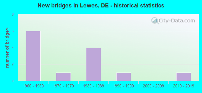
- New bridges - historical statistics
- 61960-1969
- 11970-1979
- 41980-1989
- 11990-1999
- 12010-2019


- Bridge Condition - Deck
- 18.2%Very good
- 54.5%Good
- 27.3%Satisfactory

- Bridge Condition - Superstructure
- 18.2%Very good
- 36.4%Good
- 45.5%Satisfactory

- Bridge Condition - Substructure
- 9.1%Good
- 81.8%Satisfactory
- 9.1%Fair

- Bridge Condition - Channel
- 70.0%Very good
- 20.0%Good
- 10.0%Fair
Find on map >> Show street view
Structure Number: 3154 018, Location: LEWES (Lat: 38.775703, Lng: -75.137703), Route carried "on" structure: Business US 9B, Year Built: 1983, Status: Posted for load, Structure Length: 4.55m (14.93ft), Average Daily Traffic: 5,124 (year 2021), Truck Traffic: 11%, Average Future Daily Traffic: 6,308 (year 2043), Design Load: HS 20, Features Intersected: LEWES-REHOBOTH CANAL, Facility Carried by Structure: SAVANNAH RD/US9
Minimum Vertical Clearance: 30.48m (100.00ft), Kilometerpoint: 55.730, Lanes on structure: 2, Owner: State Highway Agency, Approaching Roadway Width: 8.8m (28.9ft), Navigation Control: Yes ( Vertical Clearance: 4.6m (15.1ft), Horizontal Clearance: 21.3m (69.9ft)), Material/Design: Steel, Design/Construction: Movable - Bascule, Number Of Spans In Main Unit: 1, Number Of Approach Spans: 2, Length of Maximum Span: 25.9m (85.0ft), Curb or Sidewalk Widths: Left: 1.2m (3.9ft), Right: 1.2m (3.9ft), Curb-To-Curb Width: 8.8m (28.9ft), Out-to-Out Width: 9.5m (31.2ft)
Condition: Deck: Satisfactory, Superstructure: Good, Substructure: Satisfactory, Channel: Good, Operating Rating: 39.5 metric tons, Method Used To Determine Operating Rating: Load and Resistance Factor Rating (LRFR) rating reported by rating factor(RF) method using HL-93 loadings, Inventory Rating: 31.1 metric tons, Method Used To Determine Inventory Rating: Load and Resistance Factor Rating (LRFR) rating reported by rating factor(RF) method using HL-93 loadings, Structural Evaluation: Equal to present minimum criteria, Deck Geometry: High priority of replacement, Waterway Adequacy: Equal to present desirable criteria, Approach Roadway Alignment: Equal to present desirable criteria, Bridge Posting: Required (Relationship of Operating Rating to Maximum Legal Load: 0.1 - 9.9% below), Length Of Structure Improvement: 3.78m (12.40ft), Designated Inspection Frequency: Every 24 months, Critical Feature Inspection Frequency: Every 24 months, Underwater Inspection Frequency: Every 48 months, Inspection Date: November 2021, Critical Feature Inspection Date: November 2021, Underwater Inspection Date: August 2021, Bridge Improvement Cost: $384,000, Roadway Improvement Cost: $38,000, Total Project Cost: $577,000, Deck Structure Type: Open Grating
Find on map >> Show street view
Structure Number: 3154A023, Location: LEWES (Lat: 38.773108, Lng: -75.132892), Route carried "on" structure: US 23, Year Built: 1966, Status: Open, Structure Length: 10.94m (35.89ft), Average Daily Traffic: 2,988 (year 2020), Truck Traffic: 7%, Average Future Daily Traffic: 3,713 (year 2043), Design Load: HS 20, Features Intersected: LEWES-REHOBOTH CANAL, Facility Carried by Structure: FREEMAN HIGHWAY
Minimum Vertical Clearance: 30.48m (100.00ft), Kilometerpoint: 1.560, Lanes on structure: 2, Lanes under structure: 2, Base Highway Network: Yes, Owner: Local Toll Authority, Approaching Roadway Width: 13.4m (44.0ft), Skew: 1 degrees, Navigation Control: Yes ( Vertical Clearance: 10.7m (35.1ft), Horizontal Clearance: 30.5m (100.1ft)), Material/Design: Steel continuous, Design/Construction: Stringer/Multi-beam, Number Of Spans In Main Unit: 3, Number Of Approach Spans: 1, Length of Maximum Span: 38.1m (125.0ft), Curb-To-Curb Width: 10.8m (35.4ft), Out-to-Out Width: 11.7m (38.4ft)
Condition: Deck: Good, Superstructure: Good, Substructure: Good, Channel: Very good, Operating Rating: 35.0 metric tons, Method Used To Determine Operating Rating: Load and Resistance Factor Rating (LRFR) rating reported by rating factor(RF) method using HL-93 loadings, Inventory Rating: 26.9 metric tons, Method Used To Determine Inventory Rating: Load and Resistance Factor Rating (LRFR) rating reported by rating factor(RF) method using HL-93 loadings, Structural Evaluation: Equal to present minimum criteria, Deck Geometry: Somewhat better than minimum adequacy, Underclear: Equal to present desirable criteria, Waterway Adequacy: Superior to present desirable criteria, Approach Roadway Alignment: Equal to present desirable criteria, Length Of Structure Improvement: 10.94m (35.89ft), Designated Inspection Frequency: Every 24 months, Underwater Inspection Frequency: Every 60 months, Inspection Date: March 2021, Underwater Inspection Date: July 2017, Bridge Improvement Cost: $1,400,000, Roadway Improvement Cost: $140,000, Total Project Cost: $2,100,000, Deck Structure Type: Concrete Cast-file-Place, Wearing Surface/Protective System: Wearing Surface: Bituminous
Find on map >> Show street view
Structure Number: 3154B019A, Location: LEWES FERRY (Lat: 38.782328, Lng: -75.119783), Route carried "on" structure: US 9, Year Built: 1964, Year Reconstructed: 2021, Status: Open, Structure Length: 1.86m (6.10ft), Average Daily Traffic: 1,237 (year 2020), Truck Traffic: 4%, Average Future Daily Traffic: 1,508 (year 2040), Design Load: HL 93, Features Intersected: DELAWARE BAY
Minimum Vertical Clearance: 6.10m (20.01ft), Kilometerpoint: 49.713, Lanes on structure: 1, Base Highway Network: Yes, Toll: Toll bridge, Owner: Local Toll Authority, Approaching Roadway Width: 5.3m (17.4ft), Material/Design: Steel, Design/Construction: Movable - Lift, Number Of Spans In Main Unit: 1, Length of Maximum Span: 18.6m (61.0ft), Curb or Sidewalk Widths: Left: 0.3m (1.0ft), Right: 0.3m (1.0ft), Curb-To-Curb Width: 3.5m (11.5ft), Out-to-Out Width: 4.0m (13.1ft)
Condition: Deck: Very good, Superstructure: Very good, Substructure: Satisfactory, Channel: Very good, Operating Rating: 42.8 metric tons, Method Used To Determine Operating Rating: Load and Resistance Factor Rating (LRFR) rating reported by rating factor(RF) method using HL-93 loadings, Inventory Rating: 33.0 metric tons, Method Used To Determine Inventory Rating: Load and Resistance Factor Rating (LRFR) rating reported by rating factor(RF) method using HL-93 loadings, Structural Evaluation: Equal to present minimum criteria, Deck Geometry: High priority of replacement, Waterway Adequacy: Equal to present desirable criteria, Approach Roadway Alignment: Equal to present desirable criteria, Length Of Structure Improvement: 1.86m (6.10ft), Designated Inspection Frequency: Every 24 months, Critical Feature Inspection Frequency: Every 24 months, Inspection Date: March 2021, Critical Feature Inspection Date: March 2021, Bridge Improvement Cost: $501,000, Total Project Cost: $861,000 ( Estimate for 2015), Deck Structure Type: Open Grating
Find on map >> Show street view
Structure Number: 3154C019A, Location: LEWES FERRY (Lat: 38.782222, Lng: -75.119400), Route carried "on" structure: US 9, Year Built: 1964, Year Reconstructed: 2021, Status: Open, Structure Length: 1.86m (6.10ft), Average Daily Traffic: 1,237 (year 2020), Truck Traffic: 4%, Average Future Daily Traffic: 1,596 (year 2042), Design Load: HL 93, Features Intersected: DELAWARE BAY
Minimum Vertical Clearance: 6.10m (20.01ft), Kilometerpoint: 49.713, Lanes on structure: 1, Base Highway Network: Yes, Toll: Toll bridge, Owner: Local Toll Authority, Approaching Roadway Width: 5.3m (17.4ft), Material/Design: Steel, Design/Construction: Movable - Lift, Number Of Spans In Main Unit: 1, Length of Maximum Span: 18.6m (61.0ft), Curb or Sidewalk Widths: Left: 0.3m (1.0ft), Right: 0.3m (1.0ft), Curb-To-Curb Width: 3.5m (11.5ft), Out-to-Out Width: 4.0m (13.1ft)
Condition: Deck: Very good, Superstructure: Very good, Substructure: Satisfactory, Channel: Very good, Operating Rating: 42.8 metric tons, Method Used To Determine Operating Rating: Load and Resistance Factor Rating (LRFR) rating reported by rating factor(RF) method using HL-93 loadings, Inventory Rating: 33.0 metric tons, Method Used To Determine Inventory Rating: Load and Resistance Factor Rating (LRFR) rating reported by rating factor(RF) method using HL-93 loadings, Structural Evaluation: Equal to present minimum criteria, Deck Geometry: High priority of replacement, Waterway Adequacy: Equal to present desirable criteria, Approach Roadway Alignment: Equal to present desirable criteria, Length Of Structure Improvement: 1.86m (6.10ft), Designated Inspection Frequency: Every 24 months, Critical Feature Inspection Frequency: Every 24 months, Inspection Date: March 2021, Critical Feature Inspection Date: March 2021, Bridge Improvement Cost: $543,000, Total Project Cost: $903,000 ( Estimate for 2015), Deck Structure Type: Open Grating
Find on map >> Show street view
Structure Number: 3708 024, Location: WEST OF REHOBOTH BEACH (Lat: 38.703486, Lng: -75.161711), Route carried "on" structure: State highway 24, Year Built: 1992, Status: Open, Structure Length: 18.48m (60.63ft), Average Daily Traffic: 15,735 (year 2020), Truck Traffic: 12%, Average Future Daily Traffic: 19,557 (year 2043), Design Load: HS 20, Features Intersected: LOVE CREEK, Facility Carried by Structure: JOHN WILLIAMS HGWY
Minimum Vertical Clearance: 30.48m (100.00ft), Kilometerpoint: 61.332, Lanes on structure: 2, Owner: State Highway Agency, Approaching Roadway Width: 13.4m (44.0ft), Navigation Control: Yes ( Vertical Clearance: 2.0m (6.6ft), Horizontal Clearance: 16.8m (55.1ft)), Material/Design: Prestressed concrete, Design/Construction: Stringer/Multi-beam, Number Of Spans In Main Unit: 10, Length of Maximum Span: 18.1m (59.4ft), Curb or Sidewalk Widths: Left: 1.5m (4.9ft), Right: 0.0m, Curb-To-Curb Width: 13.4m (44.0ft), Out-to-Out Width: 16.1m (52.8ft)
Condition: Deck: Good, Superstructure: Good, Substructure: Satisfactory, Channel: Very good, Inventory Rating: 87.4 metric tons, Method Used To Determine Inventory Rating: Load Factor (LF), Structural Evaluation: Equal to present minimum criteria, Deck Geometry: Equal to present minimum criteria, Waterway Adequacy: Better than present minimum criteria, Approach Roadway Alignment: Equal to present desirable criteria, Designated Inspection Frequency: Every 24 months, Underwater Inspection Frequency: Every 48 months, Inspection Date: July 2021, Underwater Inspection Date: May 2021, Deck Structure Type: Concrete Cast-file-Place, Wearing Surface/Protective System: Wearing Surface: Monolithic Concrete, Deck Protection: Epoxy Coated Reinforcing
Find on map >> Show street view
Structure Number: 3713 277, Location: SOUTH OF NASSUA (Lat: 38.717678, Lng: -75.186886), Route carried "on" structure: County highway 277, Year Built: 2016, Status: Open, Structure Length: 0.77m (2.53ft), Average Daily Traffic: 5,522 (year 2019), Truck Traffic: 9%, Average Future Daily Traffic: 5,458 (year 2037), Design Load: HL 93, Features Intersected: LOVE CREEK, Facility Carried by Structure: ROBINSONVILLE RD
Minimum Vertical Clearance: 30.48m (100.00ft), Kilometerpoint: 7.564, Lanes on structure: 2, Owner: State Highway Agency, Approaching Roadway Width: 7.3m (24.0ft), Material/Design: Concrete, Design/Construction: Culvert, Number Of Spans In Main Unit: 1, Length of Maximum Span: 7.7m (25.3ft), Curb-To-Curb Width: 15.6m (51.2ft), Out-to-Out Width: 16.2m (53.1ft)
Condition: Channel: Good, Culverts: Good, Operating Rating: 54.4 metric tons, Method Used To Determine Operating Rating: Load and Resistance Factor Rating (LRFR) rating reported by rating factor(RF) method using HL-93 loadings, Inventory Rating: 41.8 metric tons, Method Used To Determine Inventory Rating: Load and Resistance Factor Rating (LRFR) rating reported by rating factor(RF) method using HL-93 loadings, Structural Evaluation: Better than present minimum criteria, Deck Geometry: Superior to present desirable criteria, Waterway Adequacy: Better than present minimum criteria, Approach Roadway Alignment: Equal to present minimum criteria, Length Of Structure Improvement: 1.09m (3.58ft), Designated Inspection Frequency: Every 24 months, Inspection Date: July 2020, Bridge Improvement Cost: $210,000, Roadway Improvement Cost: $32,000, Total Project Cost: $242,000
Find on map >> Show street view
Structure Number: 3714 266, Location: WEST OF LEWES (Lat: 38.770347, Lng: -75.162294), Route carried "on" structure: County highway 266, Year Built: 1989, Status: Open, Structure Length: 0.98m (3.22ft), Average Daily Traffic: 3,695 (year 2020), Truck Traffic: 9%, Average Future Daily Traffic: 4,592 (year 2043), Design Load: HS 20+Mod, Features Intersected: CANARY CREEK, Facility Carried by Structure: NEW RD
Minimum Vertical Clearance: 30.48m (100.00ft), Kilometerpoint: 3.508, Lanes on structure: 2, Owner: State Highway Agency, Approaching Roadway Width: 6.7m (22.0ft), Material/Design: Wood or Timber, Design/Construction: Slab, Number Of Spans In Main Unit: 1, Length of Maximum Span: 9.1m (29.9ft), Curb-To-Curb Width: 11.0m (36.1ft), Out-to-Out Width: 11.7m (38.4ft)
Condition: Deck: Satisfactory, Superstructure: Satisfactory, Substructure: Fair, Channel: Very good, Operating Rating: 72.9 metric tons, Method Used To Determine Operating Rating: Load Factor (LF), Inventory Rating: 53.3 metric tons, Method Used To Determine Inventory Rating: Load Factor (LF), Structural Evaluation: Somewhat better than minimum adequacy, Deck Geometry: Somewhat better than minimum adequacy, Waterway Adequacy: Better than present minimum criteria, Approach Roadway Alignment: Equal to present desirable criteria, Designated Inspection Frequency: Every 24 months, Inspection Date: August 2021, Deck Structure Type: Wood or Timber, Wearing Surface/Protective System: Wearing Surface: Bituminous
Find on map >> Show street view
Structure Number: 3715 267, Location: LEWES (Lat: 38.788975, Lng: -75.165356), Route carried "on" structure: County highway 267, Year Built: 1986, Status: Open, Structure Length: 1.97m (6.46ft), Average Daily Traffic: 2,220 (year 2019), Truck Traffic: 10%, Average Future Daily Traffic: 2,759 (year 2042), Design Load: HS 20, Features Intersected: CANARY CREEK, Facility Carried by Structure: PILOT TOWN RD
Minimum Vertical Clearance: 30.48m (100.00ft), Kilometerpoint: 6.940, Lanes on structure: 2, Owner: State Highway Agency, Approaching Roadway Width: 5.5m (18.0ft), Material/Design: Prestressed concrete, Design/Construction: Box Beam or Girders - Multiple, Number Of Spans In Main Unit: 1, Length of Maximum Span: 17.8m (58.4ft), Curb-To-Curb Width: 10.9m (35.8ft), Out-to-Out Width: 11.7m (38.4ft)
Condition: Deck: Good, Superstructure: Satisfactory, Substructure: Satisfactory, Channel: Fair, Operating Rating: 52.8 metric tons, Method Used To Determine Operating Rating: Load and Resistance Factor Rating (LRFR) rating reported by rating factor(RF) method using HL-93 loadings, Inventory Rating: 41.8 metric tons, Method Used To Determine Inventory Rating: Load and Resistance Factor Rating (LRFR) rating reported by rating factor(RF) method using HL-93 loadings, Structural Evaluation: Equal to present minimum criteria, Deck Geometry: Somewhat better than minimum adequacy, Waterway Adequacy: Somewhat better than minimum adequacy, Approach Roadway Alignment: Equal to present desirable criteria, Designated Inspection Frequency: Every 24 months, Underwater Inspection Frequency: Every 24 months, Inspection Date: June 2020, Underwater Inspection Date: April 2020, Deck Structure Type: Concrete Cast-file-Place, Wearing Surface/Protective System: Wearing Surface: Monolithic Concrete, Deck Protection: Epoxy Coated Reinforcing
Find on map >> Show street view
Structure Number: 3725N014, Location: NASSAU (Lat: 38.751089, Lng: -75.189292), Route carried "on" structure: State highway 1, Year Built: 1967, Status: Open, Structure Length: 4.37m (14.34ft), Average Daily Traffic: 13,989 (year 2020), Truck Traffic: 12%, Average Future Daily Traffic: 17,387 (year 2043), Design Load: HS 20, Features Intersected: DELAWARE COASTLINE R/R
Minimum Vertical Clearance: 30.48m (100.00ft), Kilometerpoint: 11.957, Lanes on structure: 2, Base Highway Network: Yes, Owner: State Highway Agency, Approaching Roadway Width: 12.2m (40.0ft), Skew: 1 degrees, Material/Design: Steel, Design/Construction: Stringer/Multi-beam, Number Of Spans In Main Unit: 3, Length of Maximum Span: 13.9m (45.6ft), Curb-To-Curb Width: 11.6m (38.1ft), Out-to-Out Width: 13.1m (43.0ft)
Condition: Deck: Good, Superstructure: Good, Substructure: Satisfactory, Operating Rating: 37.6 metric tons, Method Used To Determine Operating Rating: Load and Resistance Factor Rating (LRFR) rating reported by rating factor(RF) method using HL-93 loadings, Inventory Rating: 28.8 metric tons, Method Used To Determine Inventory Rating: Load and Resistance Factor Rating (LRFR) rating reported by rating factor(RF) method using HL-93 loadings, Structural Evaluation: Equal to present minimum criteria, Deck Geometry: Better than present minimum criteria, Approach Roadway Alignment: Equal to present desirable criteria, Designated Inspection Frequency: Every 24 months, Inspection Date: July 2021, Deck Structure Type: Concrete Cast-file-Place, Wearing Surface/Protective System: Wearing Surface: Latex Concrete
Find on map >> Show street view
Structure Number: 3725S014, Location: NASSAU (Lat: 38.750997, Lng: -75.189575), Route carried "on" structure: State highway 1, Year Built: 1967, Status: Open, Structure Length: 4.36m (14.30ft), Average Daily Traffic: 13,988 (year 2020), Truck Traffic: 12%, Average Future Daily Traffic: 17,386 (year 2043), Design Load: HS 20, Features Intersected: DELAWARE COASTLINE R/R
Minimum Vertical Clearance: 30.48m (100.00ft), Kilometerpoint: 68.429, Lanes on structure: 2, Base Highway Network: Yes, Owner: State Highway Agency, Approaching Roadway Width: 11.8m (38.7ft), Skew: 1 degrees, Material/Design: Steel, Design/Construction: Stringer/Multi-beam, Number Of Spans In Main Unit: 3, Length of Maximum Span: 13.8m (45.3ft), Curb-To-Curb Width: 11.6m (38.1ft), Out-to-Out Width: 13.1m (43.0ft)
Condition: Deck: Good, Superstructure: Satisfactory, Substructure: Satisfactory, Operating Rating: 37.6 metric tons, Method Used To Determine Operating Rating: Load and Resistance Factor Rating (LRFR) rating reported by rating factor(RF) method using HL-93 loadings, Inventory Rating: 28.8 metric tons, Method Used To Determine Inventory Rating: Load and Resistance Factor Rating (LRFR) rating reported by rating factor(RF) method using HL-93 loadings, Structural Evaluation: Equal to present minimum criteria, Deck Geometry: Better than present minimum criteria, Approach Roadway Alignment: Equal to present desirable criteria, Designated Inspection Frequency: Every 24 months, Inspection Date: July 2021, Deck Structure Type: Concrete Cast-file-Place, Wearing Surface/Protective System: Wearing Surface: Latex Concrete
Find on map >> Show street view
Structure Number: 3811 016, Location: WEST OF BROADKILL BEACH (Lat: 38.819694, Lng: -75.227872), Route carried "on" structure: State highway 16, Year Built: 1989, Status: Open, Structure Length: 1.33m (4.36ft), Average Daily Traffic: 2,366 (year 2019), Truck Traffic: 10%, Average Future Daily Traffic: 2,940 (year 2042), Design Load: HS 20, Features Intersected: TRIB. OF BROADKILL RIVER, Facility Carried by Structure: BROADKILL RD.
Minimum Vertical Clearance: 30.48m (100.00ft), Kilometerpoint: 42.500, Lanes on structure: 2, Owner: State Highway Agency, Approaching Roadway Width: 7.6m (24.9ft), Skew: 4 degrees, Material/Design: Prestressed concrete, Design/Construction: Box Beam or Girders - Multiple, Number Of Spans In Main Unit: 1, Length of Maximum Span: 12.4m (40.7ft), Curb-To-Curb Width: 13.7m (44.9ft), Out-to-Out Width: 14.5m (47.6ft)
Condition: Deck: Good, Superstructure: Satisfactory, Substructure: Satisfactory, Channel: Very good, Operating Rating: 48.6 metric tons, Method Used To Determine Operating Rating: Load and Resistance Factor Rating (LRFR) rating reported by rating factor(RF) method using HL-93 loadings, Inventory Rating: 41.1 metric tons, Method Used To Determine Inventory Rating: Load and Resistance Factor Rating (LRFR) rating reported by rating factor(RF) method using HL-93 loadings, Structural Evaluation: Equal to present minimum criteria, Deck Geometry: Superior to present desirable criteria, Waterway Adequacy: Equal to present minimum criteria, Approach Roadway Alignment: Equal to present desirable criteria, Designated Inspection Frequency: Every 24 months, Underwater Inspection Frequency: Every 48 months, Inspection Date: September 2020, Underwater Inspection Date: September 2020, Deck Structure Type: Concrete Cast-file-Place, Wearing Surface/Protective System: Wearing Surface: Monolithic Concrete, Deck Protection: Epoxy Coated Reinforcing
Find on map >> Show street view
Structure Number: 3812 016, Location: BROADKILL BEACH (Lat: 38.827297, Lng: -75.213164), Route carried "on" structure: State highway 16, Year Built: 1977, Status: Open, Structure Length: 6.68m (21.92ft), Average Daily Traffic: 1,881 (year 2020), Truck Traffic: 12%, Average Future Daily Traffic: 2,337 (year 2043), Design Load: HS 20, Features Intersected: BROADKILL SOUND
Minimum Vertical Clearance: 30.48m (100.00ft), Kilometerpoint: 44.305, Lanes on structure: 2, Owner: State Highway Agency, Approaching Roadway Width: 8.6m (28.2ft), Skew: 1 degrees, Material/Design: Prestressed concrete, Design/Construction: Box Beam or Girders - Multiple, Number Of Spans In Main Unit: 5, Length of Maximum Span: 12.8m (42.0ft), Curb or Sidewalk Widths: Left: 0.0m, Right: 1.2m (3.9ft), Curb-To-Curb Width: 10.6m (34.8ft), Out-to-Out Width: 12.7m (41.7ft)
Condition: Deck: Satisfactory, Superstructure: Satisfactory, Substructure: Satisfactory, Channel: Very good, Operating Rating: 30.1 metric tons, Method Used To Determine Operating Rating: Load and Resistance Factor Rating (LRFR) rating reported by rating factor(RF) method using HL-93 loadings, Inventory Rating: 23.3 metric tons, Method Used To Determine Inventory Rating: Load and Resistance Factor Rating (LRFR) rating reported by rating factor(RF) method using HL-93 loadings, Structural Evaluation: Equal to present minimum criteria, Deck Geometry: Equal to present minimum criteria, Waterway Adequacy: Equal to present desirable criteria, Approach Roadway Alignment: Equal to present desirable criteria, Designated Inspection Frequency: Every 24 months, Inspection Date: September 2021, Deck Structure Type: Concrete Precast Panels, Wearing Surface/Protective System: Wearing Surface: Bituminous
Find on map >> Show street view
Structure Number: 3154A023, Location: LEWES (Lat: 38.773108, Lng: -75.132892), Route carried "under" structure: County highway 267, Year Built: 1966, Structure Length: 0. m, Average Daily Traffic: 2,812 (year 2020), Truck Traffic: 8%, Features Intersected: LEWES-REHOBOTH CANAL, Facility Carried by Structure: FREEMAN HIGHWAY
Minimum Vertical Clearance: 8.99m (29.49ft), Kilometerpoint: 3.203, Lanes on structure: 2, Lanes under structure: 2, Material/Design: Steel continuous, Design/Construction: Stringer/Multi-beam, Length of Maximum Span: 38.1m (125.0ft)