Bridge Statistics for Leslie, Michigan (MI)
Condition, Traffic, Stress, Structural Evaluation, Project Costs
- National Bridge Inventory (NBI) Statistics
- 19Number of bridges
- 174ft / 53.4mTotal length
- $297,000Total costs
- 696,950Total average daily traffic
- 52,414Total average daily truck traffic
- National Bridge Inventory (NBI) Registered Bridges for Leslie
- No street view available for this location
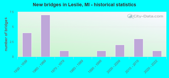
- New bridges - historical statistics
- 41950-1959
- 71960-1969
- 11970-1979
- 11990-1999
- 22000-2009
- 32010-2019
- 12020-2022

- Reconstructed bridges - Historical Statistics
- 21980-1989
- 01990-1999
- 42000-2009


- Bridge Condition - Deck
- 33.3%Good
- 33.3%Satisfactory
- 33.3%Fair

- Bridge Condition - Superstructure
- 25.0%Very good
- 8.3%Good
- 8.3%Satisfactory
- 58.3%Fair

- Bridge Condition - Substructure
- 25.0%Very good
- 41.7%Good
- 25.0%Satisfactory
- 8.3%Fair

- Bridge Condition - Channel
- 8.3%Very good
- 41.7%Good
- 41.7%Satisfactory
- 8.3%Fair

- Bridge Condition - Culverts
- 33.3%Excellent
- 66.7%Very good
Find on map >> Show street view
Structure Number: 37, Location: 0.3 MI N OF JACKSON COL (Lat: 42.428956, Lng: -84.438542), Route carried "on" structure: US 127, Year Built: 1957, Year Reconstructed: 2007, Status: Open, Structure Length: 9.29m (30.48ft), Average Daily Traffic: 9,599 (year 2007), Truck Traffic: 9%, Average Future Daily Traffic: 11,527 (year 2018), Design Load: HS 20, Features Intersected: CONRAIL & HUNTOON CREEK
Minimum Vertical Clearance: 30.48m (100.00ft), Kilometerpoint: 0.882, Lanes on structure: 2, Base Highway Network: Yes (Inventory Route: 35, Subroute: 9), Owner: State Highway Agency, Approaching Roadway Width: 12.5m (41.0ft), Skew: 4 degrees, Material/Design: Steel, Design/Construction: Stringer/Multi-beam, Number Of Spans In Main Unit: 4, Length of Maximum Span: 23.9m (78.4ft), Curb-To-Curb Width: 10.1m (33.1ft), Out-to-Out Width: 11.1m (36.4ft)
Condition: Deck: Satisfactory, Superstructure: Fair, Substructure: Satisfactory, Channel: Satisfactory, Inventory Rating: 61.6 metric tons, Method Used To Determine Inventory Rating: Load Factor (LF), Structural Evaluation: Somewhat better than minimum adequacy, Deck Geometry: Somewhat better than minimum adequacy, Underclear: Superior to present desirable criteria, Waterway Adequacy: Equal to present desirable criteria, Approach Roadway Alignment: Equal to present desirable criteria, Designated Inspection Frequency: Every 24 months, Inspection Date: June 2020, Bridge Improvement Cost: $257,000, Deck Structure Type: Concrete Cast-file-Place, Wearing Surface/Protective System: Wearing Surface: Monolithic Concrete, Deck Protection: Epoxy Coated Reinforcing
Find on map >> Show street view
Structure Number: 3701, Location: 0.3 MI N OF JACKSON COL (Lat: 42.428725, Lng: -84.438644), Route carried "on" structure: US 127, Year Built: 1957, Year Reconstructed: 2007, Status: Open, Structure Length: 9.29m (30.48ft), Average Daily Traffic: 9,599 (year 2007), Truck Traffic: 9%, Average Future Daily Traffic: 11,527 (year 2018), Design Load: HS 20, Features Intersected: CONRAIL & HUNTOON CREEK
Minimum Vertical Clearance: 30.48m (100.00ft), Kilometerpoint: 0.853, Lanes on structure: 2, Base Highway Network: Yes (Inventory Route: 35, Subroute: 6), Owner: State Highway Agency, Approaching Roadway Width: 12.5m (41.0ft), Skew: 14 degrees, Material/Design: Steel, Design/Construction: Stringer/Multi-beam, Number Of Spans In Main Unit: 4, Length of Maximum Span: 23.8m (78.1ft), Curb-To-Curb Width: 10.1m (33.1ft), Out-to-Out Width: 11.1m (36.4ft)
Condition: Deck: Satisfactory, Superstructure: Satisfactory, Substructure: Satisfactory, Channel: Satisfactory, Inventory Rating: 61.6 metric tons, Method Used To Determine Inventory Rating: Load Factor (LF), Structural Evaluation: Equal to present minimum criteria, Deck Geometry: Somewhat better than minimum adequacy, Underclear: Superior to present desirable criteria, Waterway Adequacy: Equal to present desirable criteria, Approach Roadway Alignment: Equal to present desirable criteria, Designated Inspection Frequency: Every 24 months, Inspection Date: June 2020, Bridge Improvement Cost: $257,000, Deck Structure Type: Concrete Cast-file-Place, Wearing Surface/Protective System: Wearing Surface: Monolithic Concrete, Deck Protection: Epoxy Coated Reinforcing
Find on map >> Show street view
Structure Number: 3702, Location: W LTS OF LESLIE (Lat: 42.451153, Lng: -84.443456), Route carried "on" structure: County highway 3312, Year Built: 1966, Year Reconstructed: 2014, Status: Open, Structure Length: 5.75m (18.86ft), Average Daily Traffic: 7,500 (year 2012), Average Future Daily Traffic: 9,000 (year 2032), Design Load: H 20, Features Intersected: US-127, Facility Carried by Structure: BELLEVUE RD
Minimum Vertical Clearance: 30.48m (100.00ft), Kilometerpoint: 9.627, Lanes on structure: 2, Lanes under structure: 6, Owner: State Highway Agency, Approaching Roadway Width: 12.8m (42.0ft), Material/Design: Steel, Design/Construction: Stringer/Multi-beam, Number Of Spans In Main Unit: 4, Length of Maximum Span: 19.4m (63.6ft), Curb-To-Curb Width: 9.1m (29.9ft), Out-to-Out Width: 11.1m (36.4ft)
Condition: Deck: Satisfactory, Superstructure: Fair, Substructure: Good, Operating Rating: 67.7 metric tons, Method Used To Determine Operating Rating: Load Factor (LF) rating reported by rating factor (RF) method using MS18 loading, Inventory Rating: 40.5 metric tons, Method Used To Determine Inventory Rating: Load Factor (LF) rating reported by rating factor (RF) method using MS18 loading, Structural Evaluation: Somewhat better than minimum adequacy, Deck Geometry: High priority of corrective action, Underclear: Meets minimum limits, Approach Roadway Alignment: Equal to present minimum criteria, Designated Inspection Frequency: Every 24 months, Inspection Date: June 2020, Deck Structure Type: Concrete Cast-file-Place, Wearing Surface/Protective System: Wearing Surface: Latex Concrete
Find on map >> Show street view
Structure Number: 3703, Location: 4.2MI N OF JACKSON CO LIN (Lat: 42.480286, Lng: -84.443589), Route carried "on" structure: County highway , Year Built: 1967, Status: Open, Structure Length: 5.09m (16.70ft), Average Daily Traffic: 600,480 (year 2012), Truck Traffic: 5%, Average Future Daily Traffic: 700 (year 2032), Design Load: H 15, Features Intersected: US-127, Facility Carried by Structure: COVERT RD
Minimum Vertical Clearance: 30.48m (100.00ft), Kilometerpoint: 8.020, Lanes on structure: 2, Lanes under structure: 4, Owner: State Highway Agency, Approaching Roadway Width: 11.5m (37.7ft), Material/Design: Steel continuous, Design/Construction: Stringer/Multi-beam, Number Of Spans In Main Unit: 2, Length of Maximum Span: 25.1m (82.3ft), Curb-To-Curb Width: 8.5m (27.9ft), Out-to-Out Width: 10.4m (34.1ft)
Condition: Deck: Fair, Superstructure: Fair, Substructure: Good, Operating Rating: 61.9 metric tons, Method Used To Determine Operating Rating: Load Factor (LF) rating reported by rating factor (RF) method using MS18 loading, Inventory Rating: 32.1 metric tons, Method Used To Determine Inventory Rating: Load Factor (LF) rating reported by rating factor (RF) method using MS18 loading, Structural Evaluation: Somewhat better than minimum adequacy, Deck Geometry: High priority of replacement, Underclear: Somewhat better than minimum adequacy, Approach Roadway Alignment: Equal to present desirable criteria, Designated Inspection Frequency: Every 24 months, Inspection Date: June 2020, Deck Structure Type: Concrete Cast-file-Place, Wearing Surface/Protective System: Wearing Surface: Latex Concrete
Find on map >> Show street view
Structure Number: 3861, Location: 0.2 MILES NW OF LESLIE (Lat: 42.459464, Lng: -84.419492), Route carried "on" structure: County highway , Year Built: 1974, Status: Open, Structure Length: 0.73m (2.40ft), Average Daily Traffic: 700 (year 2006), Average Future Daily Traffic: 796 (year 2027), Design Load: HS 20, Features Intersected: HUNTOON LAKE DRAIN, Facility Carried by Structure: KIRBY ROAD
Minimum Vertical Clearance: 30.48m (100.00ft), Kilometerpoint: 1.193, Lanes on structure: 2, Owner: County Highway Agency, Approaching Roadway Width: 9.8m (32.2ft), Skew: 1 degrees, Material/Design: Prestressed concrete, Design/Construction: Box Beam or Girders - Multiple, Number Of Spans In Main Unit: 1, Length of Maximum Span: 6.7m (22.0ft), Curb-To-Curb Width: 11.0m (36.1ft), Out-to-Out Width: 11.1m (36.4ft)
Condition: Deck: Fair, Superstructure: Fair, Substructure: Good, Channel: Fair, Operating Rating: 97.2 metric tons, Method Used To Determine Operating Rating: Load Factor (LF) rating reported by rating factor (RF) method using MS18 loading, Inventory Rating: 71.9 metric tons, Method Used To Determine Inventory Rating: Load Factor (LF) rating reported by rating factor (RF) method using MS18 loading, Structural Evaluation: Somewhat better than minimum adequacy, Deck Geometry: Better than present minimum criteria, Waterway Adequacy: Equal to present desirable criteria, Approach Roadway Alignment: Equal to present desirable criteria, Length Of Structure Improvement: 0.73m (2.40ft), Designated Inspection Frequency: Every 24 months, Inspection Date: June 2020, Bridge Improvement Cost: $47,000, Roadway Improvement Cost: $21,000, Total Project Cost: $68,000, Deck Structure Type: Concrete Precast Panels, Wearing Surface/Protective System: Wearing Surface: Bituminous, Membrane: Preformed Fabric
Find on map >> Show street view
Structure Number: 3903, Location: 1 M S & 2.3 M W OF LESLIE (Lat: 42.436625, Lng: -84.474914), Route carried "on" structure: County highway , Year Built: 2019, Status: Open, Structure Length: 0.73m (2.40ft), Average Daily Traffic: 280 (year 2019), Truck Traffic: 2%, Average Future Daily Traffic: 350 (year 2039), Design Load: Greater than HL93, Features Intersected: PERRY CREEK, Facility Carried by Structure: OLDS ROAD
Minimum Vertical Clearance: 30.48m (100.00ft), Kilometerpoint: 5.483, Lanes on structure: 2, Owner: County Highway Agency, Approaching Roadway Width: 7.6m (24.9ft), Material/Design: Concrete, Design/Construction: Culvert, Number Of Spans In Main Unit: 1, Length of Maximum Span: 7.3m (24.0ft), Out-to-Out Width: 15.2m (49.9ft)
Condition: Channel: Good, Culverts: Very good, Operating Rating: 42.4 metric tons, Method Used To Determine Operating Rating: Load and Resistance Factor Rating (LRFR) rating reported by rating factor(RF) method using HL-93 loadings, Inventory Rating: 32.7 metric tons, Method Used To Determine Inventory Rating: Load and Resistance Factor Rating (LRFR) rating reported by rating factor(RF) method using HL-93 loadings, Structural Evaluation: Equal to present desirable criteria, Waterway Adequacy: Better than present minimum criteria, Approach Roadway Alignment: Equal to present desirable criteria, Length Of Structure Improvement: 0.82m (2.69ft), Designated Inspection Frequency: Every 24 months, Inspection Date: January 2022, Bridge Improvement Cost: $28,000, Roadway Improvement Cost: $19,000, Total Project Cost: $47,000, Wearing Surface/Protective System: Wearing Surface: Bituminous
Find on map >> Show street view
Structure Number: 3904, Location: 1 M S & 0.4 M W OF LESLIE (Lat: 42.436622, Lng: -84.436114), Route carried "on" structure: County highway , Year Built: 2019, Status: Open, Structure Length: 0.73m (2.40ft), Average Daily Traffic: 880 (year 2019), Truck Traffic: 2%, Average Future Daily Traffic: 1,074 (year 2038), Design Load: Greater than HL93, Features Intersected: HUNTOON LAKE EXTN DRAIN, Facility Carried by Structure: OLDS ROAD
Minimum Vertical Clearance: 30.48m (100.00ft), Kilometerpoint: 0.518, Lanes on structure: 2, Owner: County Highway Agency, Approaching Roadway Width: 7.6m (24.9ft), Material/Design: Concrete, Design/Construction: Culvert, Number Of Spans In Main Unit: 1, Length of Maximum Span: 7.3m (24.0ft), Out-to-Out Width: 17.1m (56.1ft)
Condition: Channel: Good, Culverts: Very good, Operating Rating: 59.0 metric tons, Method Used To Determine Operating Rating: Load and Resistance Factor Rating (LRFR) rating reported by rating factor(RF) method using HL-93 loadings, Inventory Rating: 45.4 metric tons, Method Used To Determine Inventory Rating: Load and Resistance Factor Rating (LRFR) rating reported by rating factor(RF) method using HL-93 loadings, Structural Evaluation: Equal to present desirable criteria, Waterway Adequacy: Better than present minimum criteria, Approach Roadway Alignment: Equal to present desirable criteria, Length Of Structure Improvement: 0.82m (2.69ft), Designated Inspection Frequency: Every 24 months, Inspection Date: Febuary 2022, Bridge Improvement Cost: $26,000, Roadway Improvement Cost: $21,000, Total Project Cost: $47,000, Wearing Surface/Protective System: Wearing Surface: Bituminous
Find on map >> Show street view
Structure Number: 3959, Location: IN LESLIE (Lat: 42.447650, Lng: -84.431036), Route carried "on" structure: City street , Year Built: 2020, Status: Open, Structure Length: 0.63m (2.07ft), Average Daily Traffic: 300 (year 2018), Truck Traffic: 3%, Average Future Daily Traffic: 350 (year 2038), Design Load: Greater than HL93, Features Intersected: HUNTOON CREEK, Facility Carried by Structure: MILL STREET
Minimum Vertical Clearance: 30.48m (100.00ft), Kilometerpoint: 0.072, Lanes on structure: 2, Owner: City or Municipal Highway Agency, Approaching Roadway Width: 10.7m (35.1ft), Skew: 1 degrees, Material/Design: Concrete, Design/Construction: Culvert, Number Of Spans In Main Unit: 1, Length of Maximum Span: 6.3m (20.7ft), Curb or Sidewalk Widths: Left: 1.5m (4.9ft), Right: 3.0m (9.8ft), Curb-To-Curb Width: 10.1m (33.1ft), Out-to-Out Width: 26.2m (86.0ft)
Condition: Channel: Very good, Culverts: Excellent, Operating Rating: 84.6 metric tons, Method Used To Determine Operating Rating: Load and Resistance Factor Rating (LRFR) rating reported by rating factor(RF) method using HL-93 loadings, Inventory Rating: 65.1 metric tons, Method Used To Determine Inventory Rating: Load and Resistance Factor Rating (LRFR) rating reported by rating factor(RF) method using HL-93 loadings, Structural Evaluation: Superior to present desirable criteria, Deck Geometry: Better than present minimum criteria, Waterway Adequacy: Better than present minimum criteria, Approach Roadway Alignment: Better than present minimum criteria, Length Of Structure Improvement: 3.05m (10.01ft), Designated Inspection Frequency: Every 24 months, Inspection Date: September 2020, Bridge Improvement Cost: $120,000, Roadway Improvement Cost: $15,000, Total Project Cost: $135,000, Wearing Surface/Protective System: Wearing Surface: Bituminous
Find on map >> Show street view
Structure Number: 4453, Location: 1.5 MI S OF INGHAM COL (Lat: 42.402606, Lng: -84.428964), Route carried "on" structure: US 127, Year Built: 1957, Year Reconstructed: 1987, Status: Temporarily open, Structure Length: 2.93m (9.61ft), Average Daily Traffic: 9,599 (year 2007), Truck Traffic: 10%, Average Future Daily Traffic: 11,527 (year 2018), Design Load: HS 20, Features Intersected: GRAND RIVER
Minimum Vertical Clearance: 30.48m (100.00ft), Kilometerpoint: 14.671, Lanes on structure: 2, Base Highway Network: Yes (Inventory Route: 89, Subroute: 2), Owner: State Highway Agency, Approaching Roadway Width: 12.2m (40.0ft), Skew: 11 degrees, Material/Design: Steel, Design/Construction: Stringer/Multi-beam, Number Of Spans In Main Unit: 2, Length of Maximum Span: 14.6m (47.9ft), Curb-To-Curb Width: 12.2m (40.0ft), Out-to-Out Width: 13.8m (45.3ft)
Condition: Deck: Fair, Superstructure: Fair, Substructure: Satisfactory, Channel: Satisfactory, Operating Rating: 63.5 metric tons, Method Used To Determine Operating Rating: Load Factor (LF) rating reported by rating factor (RF) method using MS18 loading, Inventory Rating: 38.2 metric tons, Method Used To Determine Inventory Rating: Load Factor (LF) rating reported by rating factor (RF) method using MS18 loading, Structural Evaluation: Somewhat better than minimum adequacy, Deck Geometry: Better than present minimum criteria, Waterway Adequacy: Equal to present desirable criteria, Approach Roadway Alignment: Equal to present desirable criteria, Designated Inspection Frequency: Every 24 months, Underwater Inspection Frequency: Every 60 months, Inspection Date: June 2021, Underwater Inspection Date: July 2020, Deck Structure Type: Concrete Cast-file-Place, Wearing Surface/Protective System: Wearing Surface: Epoxy Overlay
Find on map >> Show street view
Structure Number: 4454, Location: 1.5 MI S OF INGHAM COL (Lat: 42.402289, Lng: -84.429200), Route carried "on" structure: US 127, Year Built: 1957, Year Reconstructed: 1987, Status: Open, Structure Length: 2.93m (9.61ft), Average Daily Traffic: 9,599 (year 2007), Truck Traffic: 10%, Average Future Daily Traffic: 11,527 (year 2018), Design Load: HS 20, Features Intersected: GRAND RIVER
Minimum Vertical Clearance: 30.48m (100.00ft), Kilometerpoint: 14.526, Lanes on structure: 2, Base Highway Network: Yes (Inventory Route: 338, Subroute: 14), Owner: State Highway Agency, Approaching Roadway Width: 12.2m (40.0ft), Skew: 11 degrees, Material/Design: Steel, Design/Construction: Stringer/Multi-beam, Number Of Spans In Main Unit: 2, Length of Maximum Span: 14.6m (47.9ft), Curb-To-Curb Width: 12.2m (40.0ft), Out-to-Out Width: 13.8m (45.3ft)
Condition: Deck: Fair, Superstructure: Fair, Substructure: Good, Channel: Satisfactory, Operating Rating: 65.4 metric tons, Method Used To Determine Operating Rating: Load Factor (LF) rating reported by rating factor (RF) method using MS18 loading, Inventory Rating: 39.2 metric tons, Method Used To Determine Inventory Rating: Load Factor (LF) rating reported by rating factor (RF) method using MS18 loading, Structural Evaluation: Somewhat better than minimum adequacy, Deck Geometry: Better than present minimum criteria, Waterway Adequacy: Equal to present desirable criteria, Approach Roadway Alignment: Equal to present desirable criteria, Designated Inspection Frequency: Every 24 months, Underwater Inspection Frequency: Every 60 months, Inspection Date: June 2021, Underwater Inspection Date: July 2020, Deck Structure Type: Concrete Cast-file-Place, Wearing Surface/Protective System: Wearing Surface: Epoxy Overlay
Find on map >> Show street view
Structure Number: 4467, Location: 0.8 MI S OF COL (Lat: 42.411478, Lng: -84.429242), Route carried "on" structure: US 127, Year Built: 1966, Year Reconstructed: 2007, Status: Open, Structure Length: 3.21m (10.53ft), Average Daily Traffic: 9,599 (year 2007), Truck Traffic: 10%, Average Future Daily Traffic: 11,527 (year 2018), Design Load: HS 20, Features Intersected: TERRITORIAL RD
Minimum Vertical Clearance: 30.48m (100.00ft), Kilometerpoint: 15.519, Lanes on structure: 2, Lanes under structure: 2, Base Highway Network: Yes (Inventory Route: 338, Subroute: 14), Owner: State Highway Agency, Approaching Roadway Width: 12.2m (40.0ft), Skew: 10 degrees, Material/Design: Steel, Design/Construction: Stringer/Multi-beam, Number Of Spans In Main Unit: 3, Length of Maximum Span: 12.8m (42.0ft), Curb-To-Curb Width: 11.6m (38.1ft), Out-to-Out Width: 12.8m (42.0ft)
Condition: Deck: Satisfactory, Superstructure: Fair, Substructure: Fair, Operating Rating: 62.2 metric tons, Method Used To Determine Operating Rating: Load Factor (LF) rating reported by rating factor (RF) method using MS18 loading, Inventory Rating: 37.3 metric tons, Method Used To Determine Inventory Rating: Load Factor (LF) rating reported by rating factor (RF) method using MS18 loading, Structural Evaluation: Somewhat better than minimum adequacy, Deck Geometry: Better than present minimum criteria, Underclear: Somewhat better than minimum adequacy, Approach Roadway Alignment: Equal to present desirable criteria, Designated Inspection Frequency: Every 16 months, Other Special Inspection Frequency: Every 6 months, Inspection Date: May 2021, Other Special Inspection Date: March 2022, Deck Structure Type: Concrete Cast-file-Place, Wearing Surface/Protective System: Wearing Surface: Latex Concrete
Find on map >> Show street view
Structure Number: 4486, Location: 1.5 MI NW RIVES (Lat: 42.403628, Lng: -84.485669), Route carried "on" structure: County highway 3845, Year Built: 1995, Status: Open, Structure Length: 3.84m (12.60ft), Average Daily Traffic: 1,150 (year 2003), Average Future Daily Traffic: 1,200 (year 2022), Design Load: HS 20, Features Intersected: GRAND RIVER, Facility Carried by Structure: RIVES EATON RD
Minimum Vertical Clearance: 30.48m (100.00ft), Kilometerpoint: 3.359, Lanes on structure: 2, Owner: County Highway Agency, Approaching Roadway Width: 9.1m (29.9ft), Skew: 2 degrees, Material/Design: Prestressed concrete, Design/Construction: Box Beam or Girders - Multiple, Number Of Spans In Main Unit: 1, Length of Maximum Span: 37.5m (123.0ft), Curb-To-Curb Width: 10.4m (34.1ft), Out-to-Out Width: 11.2m (36.7ft)
Condition: Deck: Good, Superstructure: Good, Substructure: Good, Channel: Good, Operating Rating: 81.9 metric tons, Method Used To Determine Operating Rating: Load Factor (LF), Inventory Rating: 49.1 metric tons, Method Used To Determine Inventory Rating: Load Factor (LF), Structural Evaluation: Better than present minimum criteria, Deck Geometry: Equal to present minimum criteria, Waterway Adequacy: Equal to present desirable criteria, Approach Roadway Alignment: Equal to present minimum criteria, Designated Inspection Frequency: Every 24 months, Inspection Date: October 2020, Deck Structure Type: Concrete Cast-file-Place, Wearing Surface/Protective System: Wearing Surface: Monolithic Concrete, Deck Protection: Epoxy Coated Reinforcing
Find on map >> Show street view
Structure Number: 4487, Location: 1.8 MI N RIVES JUNCTION (Lat: 42.411481, Lng: -84.473908), Route carried "on" structure: County highway , Year Built: 2003, Status: Open, Structure Length: 1.48m (4.86ft), Average Daily Traffic: 313 (year 1998), Truck Traffic: 2%, Average Future Daily Traffic: 400 (year 2017), Design Load: HS 25 or greater, Features Intersected: PERRY CREEK, Facility Carried by Structure: TERRITORIAL ROAD
Minimum Vertical Clearance: 30.48m (100.00ft), Kilometerpoint: 0.689, Lanes on structure: 2, Owner: County Highway Agency, Approaching Roadway Width: 9.4m (30.8ft), Skew: 3 degrees, Material/Design: Prestressed concrete, Design/Construction: Box Beam or Girders - Multiple, Number Of Spans In Main Unit: 1, Length of Maximum Span: 14.3m (46.9ft), Curb-To-Curb Width: 8.8m (28.9ft), Out-to-Out Width: 9.4m (30.8ft)
Condition: Deck: Good, Superstructure: Very good, Substructure: Very good, Channel: Good, Operating Rating: 77.6 metric tons, Method Used To Determine Operating Rating: Load Factor (LF), Inventory Rating: 46.5 metric tons, Method Used To Determine Inventory Rating: Load Factor (LF), Structural Evaluation: Equal to present desirable criteria, Deck Geometry: Equal to present minimum criteria, Waterway Adequacy: Equal to present desirable criteria, Approach Roadway Alignment: Equal to present desirable criteria, Designated Inspection Frequency: Every 24 months, Inspection Date: August 2021, Deck Structure Type: Concrete Cast-file-Place, Wearing Surface/Protective System: Wearing Surface: Monolithic Concrete, Deck Protection: Epoxy Coated Reinforcing
Find on map >> Show street view
Structure Number: 4495, Location: 1.2 MI N 0.6 MI E RIVES (Lat: 42.403683, Lng: -84.443356), Route carried "on" structure: ServiceCounty highway , Year Built: 2010, Status: Open, Structure Length: 3.66m (12.01ft), Average Daily Traffic: 872 (year 2009), Truck Traffic: 2%, Average Future Daily Traffic: 1,070 (year 2029), Design Load: HS 25 or greater, Features Intersected: GRAND RIVER, Facility Carried by Structure: CHURCHILL ROAD
Minimum Vertical Clearance: 30.48m (100.00ft), Kilometerpoint: 6.327, Lanes on structure: 2, Owner: County Highway Agency, Approaching Roadway Width: 9.3m (30.5ft), Material/Design: Prestressed concrete, Design/Construction: Box Beam or Girders - Multiple, Number Of Spans In Main Unit: 1, Length of Maximum Span: 36.2m (118.8ft), Curb-To-Curb Width: 9.3m (30.5ft), Out-to-Out Width: 10.0m (32.8ft)
Condition: Deck: Good, Superstructure: Very good, Substructure: Very good, Channel: Good, Operating Rating: 91.4 metric tons, Method Used To Determine Operating Rating: Load Factor (LF) rating reported by rating factor (RF) method using MS18 loading, Inventory Rating: 49.9 metric tons, Method Used To Determine Inventory Rating: Load Factor (LF) rating reported by rating factor (RF) method using MS18 loading, Structural Evaluation: Equal to present desirable criteria, Deck Geometry: Equal to present minimum criteria, Waterway Adequacy: Equal to present desirable criteria, Approach Roadway Alignment: Equal to present desirable criteria, Designated Inspection Frequency: Every 24 months, Inspection Date: October 2020, Deck Structure Type: Concrete Cast-file-Place, Wearing Surface/Protective System: Wearing Surface: Monolithic Concrete, Deck Protection: Epoxy Coated Reinforcing
Find on map >> Show street view
Structure Number: 45, Location: 1 MI N 2.5 MI E OF RIVES (Lat: 42.395992, Lng: -84.413761), Route carried "on" structure: County highway , Year Built: 2000, Status: Open, Structure Length: 3.08m (10.10ft), Average Daily Traffic: 1,600 (year 2005), Truck Traffic: 3%, Average Future Daily Traffic: 2,500 (year 2020), Design Load: HS 25 or greater, Features Intersected: GRAND RIVER, Facility Carried by Structure: LANSING AVE
Minimum Vertical Clearance: 30.48m (100.00ft), Kilometerpoint: 16.257, Lanes on structure: 2, Owner: County Highway Agency, Approaching Roadway Width: 11.9m (39.0ft), Skew: 1 degrees, Material/Design: Prestressed concrete, Design/Construction: Box Beam or Girders - Multiple, Number Of Spans In Main Unit: 1, Length of Maximum Span: 30.1m (98.8ft), Curb-To-Curb Width: 10.4m (34.1ft), Out-to-Out Width: 11.3m (37.1ft)
Condition: Deck: Good, Superstructure: Very good, Substructure: Very good, Channel: Satisfactory, Operating Rating: 94.6 metric tons, Method Used To Determine Operating Rating: Load Factor (LF) rating reported by rating factor (RF) method using MS18 loading, Inventory Rating: 56.7 metric tons, Method Used To Determine Inventory Rating: Load Factor (LF) rating reported by rating factor (RF) method using MS18 loading, Structural Evaluation: Equal to present desirable criteria, Deck Geometry: Equal to present minimum criteria, Waterway Adequacy: Equal to present desirable criteria, Approach Roadway Alignment: Equal to present desirable criteria, Designated Inspection Frequency: Every 24 months, Inspection Date: October 2020, Deck Structure Type: Concrete Cast-file-Place, Wearing Surface/Protective System: Wearing Surface: Bituminous
Find on map >> Show street view
Structure Number: 3702, Location: W LTS OF LESLIE (Lat: 42.451153, Lng: -84.443456), Route carried "under" structure: US 127, Year Built: 1966, Structure Length: 0. m, Average Daily Traffic: 16,500 (year 2012), Truck Traffic: 9%, Features Intersected: US-127, Facility Carried by Structure: BELLEVUE RD
Minimum Vertical Clearance: 4.47m (14.67ft), Kilometerpoint: 3.423, Lanes on structure: 2, Lanes under structure: 6, Material/Design: Steel, Design/Construction: Stringer/Multi-beam, Length of Maximum Span: 19.4m (63.6ft)
Find on map >> Show street view
Structure Number: 3703, Location: 4.2MI N OF JACKSON CO LIN (Lat: 42.480286, Lng: -84.443589), Route carried "under" structure: US 127, Year Built: 1967, Structure Length: 0. m, Average Daily Traffic: 18,000 (year 2012), Truck Traffic: 90%, Features Intersected: US-127, Facility Carried by Structure: COVERT RD
Minimum Vertical Clearance: 4.44m (14.57ft), Kilometerpoint: 6.658, Lanes on structure: 2, Lanes under structure: 4, Material/Design: Steel continuous, Design/Construction: Stringer/Multi-beam, Length of Maximum Span: 25.1m (82.3ft)
Find on map >> Show street view
Structure Number: 4466, Location: 0.8 MI S OF CO LINE (Lat: 42.411483, Lng: -84.428989), Route carried "under" structure: County highway , Year Built: 1966, Structure Length: 0. m, Average Daily Traffic: 190 (year 1995), Features Intersected: TERRITORIAL RD, Facility Carried by Structure: US-127 NB
Minimum Vertical Clearance: 4.52m (14.83ft), Kilometerpoint: 4.384, Lanes on structure: 2, Lanes under structure: 2, Material/Design: Steel, Design/Construction: Stringer/Multi-beam, Length of Maximum Span: 12.8m (42.0ft)
Find on map >> Show street view
Structure Number: 4467, Location: 0.8 MI S OF COL (Lat: 42.411478, Lng: -84.429242), Route carried "under" structure: County highway , Year Built: 1966, Structure Length: 0. m, Average Daily Traffic: 190 (year 1995), Features Intersected: TERRITORIAL RD, Facility Carried by Structure: US-127 SB
Minimum Vertical Clearance: 4.57m (14.99ft), Kilometerpoint: 4.363, Lanes on structure: 2, Lanes under structure: 2, Material/Design: Steel, Design/Construction: Stringer/Multi-beam, Length of Maximum Span: 12.8m (42.0ft)