Bridge Statistics for Leonard, Michigan (MI)
Condition, Traffic, Stress, Structural Evaluation, Project Costs
- National Bridge Inventory (NBI) Statistics
- 14Number of bridges
- 112ft / 33.9mTotal length
- $650,000Total costs
- 50,670Total average daily traffic
- 3,870Total average daily truck traffic
- 68,187Total future (year 2017) average daily traffic
- National Bridge Inventory (NBI) Registered Bridges for Leonard
- No street view available for this location
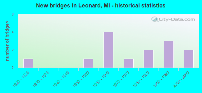
- New bridges - historical statistics
- 11920-1929
- 11950-1959
- 41960-1969
- 11970-1979
- 21980-1989
- 31990-1999
- 22000-2009


- Bridge Condition - Deck
- 27.3%Good
- 45.5%Satisfactory
- 27.3%Fair

- Bridge Condition - Superstructure
- 9.1%Very good
- 27.3%Good
- 36.4%Satisfactory
- 27.3%Fair

- Bridge Condition - Substructure
- 18.2%Very good
- 27.3%Good
- 18.2%Satisfactory
- 18.2%Fair
- 9.1%Poor
- 9.1%Serious

- Bridge Condition - Channel
- 25.0%Very good
- 50.0%Satisfactory
- 8.3%Fair
- 16.7%Poor

- Bridge Condition - Culverts
- 33.3%Very good
- 33.3%Fair
- 33.3%Poor
Find on map >> Show street view
Structure Number: 511, Location: 7 MI W OF BARAGA (Lat: 46.795075, Lng: -88.636000), Route carried "on" structure: County highway 711, Year Built: 1950, Status: Posted for load, Structure Length: 2.89m (9.48ft), Average Daily Traffic: 853 (year 2015), Truck Traffic: 8%, Average Future Daily Traffic: 1,000 (year 2035), Design Load: H 15, Features Intersected: SILVER RIVER, Facility Carried by Structure: PELKIE ROAD
Minimum Vertical Clearance: 30.48m (100.00ft), Kilometerpoint: 2.181, Lanes on structure: 2, Base Highway Network: Yes (Inventory Route: 307, Subroute: 33), Owner: County Highway Agency, Approaching Roadway Width: 9.1m (29.9ft), Material/Design: Steel continuous, Design/Construction: Stringer/Multi-beam, Number Of Spans In Main Unit: 3, Length of Maximum Span: 10.6m (34.8ft), Curb or Sidewalk Widths: Left: 0.2m (0.7ft), Right: 0.2m (0.7ft), Curb-To-Curb Width: 7.3m (24.0ft), Out-to-Out Width: 8.9m (29.2ft)
Condition: Deck: Satisfactory, Superstructure: Satisfactory, Substructure: Poor, Channel: Poor, Operating Rating: 49.2 metric tons, Method Used To Determine Operating Rating: Load Factor (LF) rating reported by rating factor (RF) method using MS18 loading, Inventory Rating: 29.2 metric tons, Method Used To Determine Inventory Rating: Load Factor (LF) rating reported by rating factor (RF) method using MS18 loading, Structural Evaluation: Meets minimum limits, Deck Geometry: Meets minimum limits, Waterway Adequacy: Equal to present minimum criteria, Approach Roadway Alignment: Meets minimum limits, Bridge Posting: Required (Relationship of Operating Rating to Maximum Legal Load: 0.1 - 9.9% below), Length Of Structure Improvement: 6.10m (20.01ft), Designated Inspection Frequency: Every 24 months, Inspection Date: September 2021, Bridge Improvement Cost: $500,000, Roadway Improvement Cost: $100,000, Total Project Cost: $650,000 ( Estimate for 2018), Deck Structure Type: Concrete Cast-file-Place, Wearing Surface/Protective System: Wearing Surface: Bituminous
Find on map >> Show street view
Structure Number: 1172, Location: OVID TWP SEC 16 (Lat: 41.858447, Lng: -85.004147), Route carried "on" structure: County highway , Year Built: 1999, Status: Open, Structure Length: 0.85m (2.79ft), Average Daily Traffic: 33 (year 2004), Average Future Daily Traffic: 44 (year 2024), Design Load: HS 20, Features Intersected: COLDWATER RIVER, Facility Carried by Structure: OTIS ROAD
Minimum Vertical Clearance: 30.48m (100.00ft), Kilometerpoint: 0.161, Lanes on structure: 2, Owner: County Highway Agency, Approaching Roadway Width: 6.1m (20.0ft), Material/Design: Steel, Design/Construction: Culvert, Number Of Spans In Main Unit: 1, Length of Maximum Span: 8.5m (27.9ft), Curb-To-Curb Width: 6.1m (20.0ft), Out-to-Out Width: 6.1m (20.0ft)
Condition: Channel: Satisfactory, Culverts: Very good, Operating Rating: 68.7 metric tons, Method Used To Determine Operating Rating: Load Factor (LF) rating reported by rating factor (RF) method using MS18 loading, Inventory Rating: 50.5 metric tons, Method Used To Determine Inventory Rating: Load Factor (LF) rating reported by rating factor (RF) method using MS18 loading, Structural Evaluation: Equal to present desirable criteria, Deck Geometry: Somewhat better than minimum adequacy, Waterway Adequacy: Equal to present minimum criteria, Approach Roadway Alignment: Equal to present desirable criteria, Designated Inspection Frequency: Every 24 months, Inspection Date: October 2020, Wearing Surface/Protective System: Wearing Surface: Gravel
Find on map >> Show street view
Structure Number: 1506, Location: 1.9 MI S OF M-27 (Lat: 45.431439, Lng: -84.606264), Route carried "on" structure: Interstate 75, Year Built: 1962, Status: Open, Structure Length: 5.76m (18.90ft), Average Daily Traffic: 4,474 (year 2007), Truck Traffic: 11%, Average Future Daily Traffic: 5,599 (year 2018), Design Load: HS 20+Mod, Features Intersected: D&M RR (ABN)
Minimum Vertical Clearance: 30.48m (100.00ft), Kilometerpoint: 27.791, Lanes on structure: 2, Base Highway Network: Yes (Inventory Route: 55, Subroute: 7), Owner: State Highway Agency, Approaching Roadway Width: 13.7m (44.9ft), Skew: 4 degrees, Material/Design: Steel, Design/Construction: Stringer/Multi-beam, Number Of Spans In Main Unit: 3, Length of Maximum Span: 19.2m (63.0ft), Curb-To-Curb Width: 12.8m (42.0ft), Out-to-Out Width: 14.3m (46.9ft)
Condition: Deck: Satisfactory, Superstructure: Satisfactory, Substructure: Fair, Operating Rating: 57.7 metric tons, Method Used To Determine Operating Rating: Load Factor (LF) rating reported by rating factor (RF) method using MS18 loading, Inventory Rating: 34.7 metric tons, Method Used To Determine Inventory Rating: Load Factor (LF) rating reported by rating factor (RF) method using MS18 loading, Structural Evaluation: Somewhat better than minimum adequacy, Deck Geometry: Equal to present desirable criteria, Approach Roadway Alignment: Somewhat better than minimum adequacy, Designated Inspection Frequency: Every 24 months, Inspection Date: April 2021, Bridge Improvement Cost: $187,000, Deck Structure Type: Concrete Cast-file-Place, Wearing Surface/Protective System: Wearing Surface: Epoxy Overlay
Find on map >> Show street view
Structure Number: 1507, Location: @ M-68 (Lat: 45.401986, Lng: -84.607392), Route carried "on" structure: State highway 68, Year Built: 1962, Status: Open, Structure Length: 4.36m (14.30ft), Average Daily Traffic: 6,551 (year 2007), Truck Traffic: 6%, Average Future Daily Traffic: 9,614 (year 2018), Design Load: HS 20+Mod, Features Intersected: I-75 SB
Minimum Vertical Clearance: 30.48m (100.00ft), Kilometerpoint: 2.128, Lanes on structure: 2, Lanes under structure: 2, Base Highway Network: Yes (Inventory Route: 54, Subroute: 7), Owner: State Highway Agency, Approaching Roadway Width: 11.8m (38.7ft), Skew: 2 degrees, Material/Design: Steel, Design/Construction: Stringer/Multi-beam, Number Of Spans In Main Unit: 3, Length of Maximum Span: 18.6m (61.0ft), Curb-To-Curb Width: 10.0m (32.8ft), Out-to-Out Width: 11.2m (36.7ft)
Condition: Deck: Fair, Superstructure: Fair, Substructure: Fair, Operating Rating: 57.0 metric tons, Method Used To Determine Operating Rating: Load Factor (LF) rating reported by rating factor (RF) method using MS18 loading, Inventory Rating: 34.3 metric tons, Method Used To Determine Inventory Rating: Load Factor (LF) rating reported by rating factor (RF) method using MS18 loading, Structural Evaluation: Somewhat better than minimum adequacy, Deck Geometry: Meets minimum limits, Underclear: Meets minimum limits, Approach Roadway Alignment: Better than present minimum criteria, Designated Inspection Frequency: Every 24 months, Inspection Date: April 2021, Deck Structure Type: Concrete Cast-file-Place, Wearing Surface/Protective System: Wearing Surface: Epoxy Overlay
Find on map >> Show street view
Structure Number: 5035, Location: 0.30 MI W OF SUMMIT AVE (Lat: 43.161031, Lng: -85.571103), Route carried "on" structure: County highway 4170, Year Built: 2002, Status: Open, Structure Length: 1.39m (4.56ft), Average Daily Traffic: 5,263 (year 2004), Average Future Daily Traffic: 8,950 (year 2024), Design Load: HS 20, Features Intersected: STEGMAN CREEK, Facility Carried by Structure: 13 MILE RD
Minimum Vertical Clearance: 30.48m (100.00ft), Kilometerpoint: 17.826, Lanes on structure: 2, Owner: County Highway Agency, Approaching Roadway Width: 12.2m (40.0ft), Material/Design: Prestressed concrete, Design/Construction: Box Beam or Girders - Multiple, Number Of Spans In Main Unit: 1, Length of Maximum Span: 12.8m (42.0ft), Curb-To-Curb Width: 12.5m (41.0ft), Out-to-Out Width: 13.6m (44.6ft)
Condition: Deck: Good, Superstructure: Very good, Substructure: Very good, Channel: Very good, Operating Rating: 88.8 metric tons, Method Used To Determine Operating Rating: Load Factor (LF) rating reported by rating factor (RF) method using MS18 loading, Inventory Rating: 53.1 metric tons, Method Used To Determine Inventory Rating: Load Factor (LF) rating reported by rating factor (RF) method using MS18 loading, Structural Evaluation: Equal to present desirable criteria, Deck Geometry: Somewhat better than minimum adequacy, Waterway Adequacy: Equal to present desirable criteria, Approach Roadway Alignment: Better than present minimum criteria, Designated Inspection Frequency: Every 24 months, Inspection Date: October 2020, Deck Structure Type: Concrete Cast-file-Place, Wearing Surface/Protective System: Wearing Surface: Bituminous
Find on map >> Show street view
Structure Number: 5695, Location: 0.1 MI NORTH OF SUTTON RD (Lat: 41.952889, Lng: -83.790950), Route carried "on" structure: County highway , Year Built: 2003, Status: Open, Structure Length: 2.07m (6.79ft), Average Daily Traffic: 80 (year 2011), Truck Traffic: 1%, Average Future Daily Traffic: 200 (year 2031), Design Load: HS 25 or greater, Features Intersected: LITTLE RAISIN RIVER, Facility Carried by Structure: RIXOM HWY
Minimum Vertical Clearance: 30.48m (100.00ft), Kilometerpoint: 1.803, Lanes on structure: 2, Owner: County Highway Agency, Approaching Roadway Width: 10.4m (34.1ft), Material/Design: Prestressed concrete, Design/Construction: Box Beam or Girders - Multiple, Number Of Spans In Main Unit: 1, Length of Maximum Span: 18.9m (62.0ft), Curb-To-Curb Width: 8.8m (28.9ft), Out-to-Out Width: 9.5m (31.2ft)
Condition: Deck: Good, Superstructure: Good, Substructure: Very good, Channel: Very good, Operating Rating: 82.4 metric tons, Method Used To Determine Operating Rating: Load Factor (LF), Inventory Rating: 49.5 metric tons, Method Used To Determine Inventory Rating: Load Factor (LF), Structural Evaluation: Better than present minimum criteria, Deck Geometry: Better than present minimum criteria, Waterway Adequacy: Superior to present desirable criteria, Approach Roadway Alignment: Superior to present desirable criteria, Designated Inspection Frequency: Every 24 months, Inspection Date: Febuary 2021, Deck Structure Type: Concrete Cast-file-Place, Wearing Surface/Protective System: Wearing Surface: Monolithic Concrete
Find on map >> Show street view
Structure Number: 5792, Location: 0.2 MI E OF INGHAM COL (Lat: 42.651350, Lng: -84.143169), Route carried "on" structure: Interstate 96, Year Built: 1961, Status: Open, Structure Length: 1.22m (4.00ft), Average Daily Traffic: 24,280 (year 2007), Truck Traffic: 11%, Average Future Daily Traffic: 32,379 (year 2018), Design Load: HS 20+Mod, Features Intersected: W BR RED CEDAR RIVER
Minimum Vertical Clearance: 30.48m (100.00ft), Kilometerpoint: 0.420, Lanes on structure: 2, Base Highway Network: Yes (Inventory Route: 93, Subroute: 7), Owner: State Highway Agency, Approaching Roadway Width: 13.4m (44.0ft), Material/Design: Prestressed concrete, Design/Construction: Stringer/Multi-beam, Number Of Spans In Main Unit: 1, Length of Maximum Span: 11.5m (37.7ft), Curb-To-Curb Width: 11.7m (38.4ft), Out-to-Out Width: 13.3m (43.6ft)
Condition: Deck: Satisfactory, Superstructure: Good, Substructure: Good, Channel: Satisfactory, Operating Rating: 76.7 metric tons, Method Used To Determine Operating Rating: Load Factor (LF), Inventory Rating: 45.9 metric tons, Method Used To Determine Inventory Rating: Load Factor (LF), Structural Evaluation: Better than present minimum criteria, Deck Geometry: Equal to present minimum criteria, Waterway Adequacy: Equal to present desirable criteria, Approach Roadway Alignment: Equal to present desirable criteria, Designated Inspection Frequency: Every 24 months, Inspection Date: September 2021, Deck Structure Type: Concrete Cast-file-Place, Wearing Surface/Protective System: Wearing Surface: Bituminous
Find on map >> Show street view
Structure Number: 6282, Location: 3.5 MILES WEST OF M-53 (Lat: 42.859108, Lng: -83.092553), Route carried "on" structure: County highway , Year Built: 1966, Status: Open, Structure Length: 1.06m (3.48ft), Average Daily Traffic: 238 (year 2010), Truck Traffic: 2%, Average Future Daily Traffic: 354 (year 2030), Design Load: HS 20, Features Intersected: SECORD LAKE OUTLET, Facility Carried by Structure: 36 MILE RD
Minimum Vertical Clearance: 30.48m (100.00ft), Kilometerpoint: 0.753, Lanes on structure: 2, Owner: County Highway Agency, Approaching Roadway Width: 9.0m (29.5ft), Material/Design: Prestressed concrete, Design/Construction: Box Beam or Girders - Multiple, Number Of Spans In Main Unit: 1, Length of Maximum Span: 9.7m (31.8ft), Curb or Sidewalk Widths: Left: 0.4m (1.3ft), Right: 0.4m (1.3ft), Curb-To-Curb Width: 9.0m (29.5ft), Out-to-Out Width: 10.1m (33.1ft)
Condition: Deck: Fair, Superstructure: Satisfactory, Substructure: Good, Channel: Satisfactory, Operating Rating: 63.2 metric tons, Method Used To Determine Operating Rating: Load Factor (LF) rating reported by rating factor (RF) method using MS18 loading, Inventory Rating: 37.9 metric tons, Method Used To Determine Inventory Rating: Load Factor (LF) rating reported by rating factor (RF) method using MS18 loading, Structural Evaluation: Equal to present minimum criteria, Deck Geometry: Equal to present minimum criteria, Waterway Adequacy: Better than present minimum criteria, Approach Roadway Alignment: Equal to present desirable criteria, Designated Inspection Frequency: Every 24 months, Inspection Date: July 2020, Deck Structure Type: Concrete Cast-file-Place, Wearing Surface/Protective System: Wearing Surface: Bituminous
Find on map >> Show street view
Structure Number: 631, Location: 0.1 MI E OF DEQUINDRE RD (Lat: 42.865761, Lng: -83.098656), Route carried "on" structure: County highway , Year Built: 1981, Status: Open, Structure Length: 0.79m (2.59ft), Average Daily Traffic: 114 (year 1997), Average Future Daily Traffic: 154 (year 2017), Design Load: H 20, Features Intersected: SECORD LAKE OUTLET, Facility Carried by Structure: PEARL DRIVE
Minimum Vertical Clearance: 30.48m (100.00ft), Kilometerpoint: 0.521, Lanes on structure: 2, Owner: County Highway Agency, Approaching Roadway Width: 10.0m (32.8ft), Material/Design: Steel, Design/Construction: Culvert, Number Of Spans In Main Unit: 3, Length of Maximum Span: 2.1m (6.9ft)
Condition: Channel: Fair, Culverts: Fair, Operating Rating: 97.2 metric tons, Method Used To Determine Operating Rating: Load Factor (LF) rating reported by rating factor (RF) method using MS18 loading, Inventory Rating: 97.2 metric tons, Method Used To Determine Inventory Rating: Load Factor (LF) rating reported by rating factor (RF) method using MS18 loading, Structural Evaluation: Somewhat better than minimum adequacy, Waterway Adequacy: Better than present minimum criteria, Approach Roadway Alignment: Better than present minimum criteria, Designated Inspection Frequency: Every 24 months, Inspection Date: August 2021
Find on map >> Show street view
Structure Number: 6552, Location: 7 MI N OF US41 (Lat: 46.609531, Lng: -88.022264), Route carried "on" structure: County highway 5210, Year Built: 1927, Status: Open, Structure Length: 2.13m (6.99ft), Average Daily Traffic: 188 (year 2001), Average Future Daily Traffic: 200 (year 2020), Design Load: HS 20+Mod, Features Intersected: PESHEKEE RIVER, Facility Carried by Structure: COUNTY HWY 607
Minimum Vertical Clearance: 30.48m (100.00ft), Kilometerpoint: 3.900, Lanes on structure: 2, Owner: County Highway Agency, Approaching Roadway Width: 7.9m (25.9ft), Material/Design: Steel, Design/Construction: Stringer/Multi-beam, Number Of Spans In Main Unit: 1, Length of Maximum Span: 20.4m (66.9ft), Curb-To-Curb Width: 5.5m (18.0ft), Out-to-Out Width: 6.9m (22.6ft)
Condition: Deck: Satisfactory, Superstructure: Satisfactory, Substructure: Satisfactory, Channel: Satisfactory, Operating Rating: 79.1 metric tons, Method Used To Determine Operating Rating: Load Factor (LF), Inventory Rating: 43.6 metric tons, Method Used To Determine Inventory Rating: Load Factor (LF), Structural Evaluation: Equal to present minimum criteria, Deck Geometry: High priority of corrective action, Waterway Adequacy: Better than present minimum criteria, Approach Roadway Alignment: Better than present minimum criteria, Designated Inspection Frequency: Every 24 months, Inspection Date: October 2021, Deck Structure Type: Concrete Cast-file-Place, Wearing Surface/Protective System: Wearing Surface: Bituminous
Find on map >> Show street view
Structure Number: 6692, Location: 2.8 MI NW OF STANWOOD (Lat: 43.607950, Lng: -85.480556), Route carried "on" structure: US 131, Year Built: 1996, Status: Open, Structure Length: 9.14m (29.99ft), Average Daily Traffic: 7,526 (year 2007), Truck Traffic: 3%, Average Future Daily Traffic: 8,145 (year 2018), Design Load: HS 25 or greater, Features Intersected: MUSKEGON RIVER
Minimum Vertical Clearance: 30.48m (100.00ft), Kilometerpoint: 16.937, Lanes on structure: 2, Owner: State Highway Agency, Approaching Roadway Width: 13.4m (44.0ft), Material/Design: Prestressed concrete, Design/Construction: Stringer/Multi-beam, Number Of Spans In Main Unit: 3, Length of Maximum Span: 32.0m (105.0ft), Curb-To-Curb Width: 13.4m (44.0ft), Out-to-Out Width: 14.3m (46.9ft)
Condition: Deck: Good, Superstructure: Good, Substructure: Good, Channel: Very good, Operating Rating: 85.0 metric tons, Method Used To Determine Operating Rating: Load Factor (LF), Inventory Rating: 38.2 metric tons, Method Used To Determine Inventory Rating: Load Factor (LF), Structural Evaluation: Better than present minimum criteria, Deck Geometry: Equal to present minimum criteria, Waterway Adequacy: Equal to present desirable criteria, Approach Roadway Alignment: Meets minimum limits, Designated Inspection Frequency: Every 24 months, Underwater Inspection Frequency: Every 60 months, Inspection Date: June 2021, Underwater Inspection Date: May 2020, Deck Structure Type: Concrete Cast-file-Place, Wearing Surface/Protective System: Wearing Surface: Monolithic Concrete, Deck Protection: Epoxy Coated Reinforcing
Find on map >> Show street view
Structure Number: 13593, Location: 0.6 MI N OF LEONARD ROAD (Lat: 42.874444, Lng: -83.112439), Route carried "on" structure: County highway , Year Built: 1990, Status: Open, Structure Length: 0.91m (2.99ft), Average Daily Traffic: 120 (year 2016), Average Future Daily Traffic: 146 (year 2036), Design Load: HS 20, Features Intersected: EAST CREEK, Facility Carried by Structure: SECORD LAKE ROAD
Minimum Vertical Clearance: 30.48m (100.00ft), Kilometerpoint: 0.917, Lanes on structure: 2, Owner: County Highway Agency, Approaching Roadway Width: 7.3m (24.0ft), Material/Design: Prestressed concrete, Design/Construction: Box Beam or Girders - Multiple, Number Of Spans In Main Unit: 1, Length of Maximum Span: 8.5m (27.9ft), Curb-To-Curb Width: 6.1m (20.0ft), Out-to-Out Width: 6.4m (21.0ft)
Condition: Deck: Satisfactory, Superstructure: Fair, Substructure: Satisfactory, Channel: Satisfactory, Operating Rating: 62.2 metric tons, Method Used To Determine Operating Rating: Load Factor (LF) rating reported by rating factor (RF) method using MS18 loading, Inventory Rating: 37.3 metric tons, Method Used To Determine Inventory Rating: Load Factor (LF) rating reported by rating factor (RF) method using MS18 loading, Structural Evaluation: Somewhat better than minimum adequacy, Deck Geometry: Meets minimum limits, Waterway Adequacy: Equal to present minimum criteria, Approach Roadway Alignment: Equal to present minimum criteria, Designated Inspection Frequency: Every 24 months, Inspection Date: September 2020, Deck Structure Type: Concrete Cast-file-Place, Wearing Surface/Protective System: Wearing Surface: Bituminous, Membrane: Preformed Fabric
Find on map >> Show street view
Structure Number: 13941, Location: ADDISON TWP SEC 25/36 (Lat: 42.815056, Lng: -83.117972), Route carried "on" structure: County highway , Year Built: 1984, Status: Posted for load, Structure Length: 0.70m (2.30ft), Average Daily Traffic: 50 (year 2016), Average Future Daily Traffic: 65 (year 2036), Design Load: HS 20, Features Intersected: STONEY CREEK, Facility Carried by Structure: BREWER ROAD
Minimum Vertical Clearance: 30.48m (100.00ft), Kilometerpoint: 1.453, Lanes on structure: 2, Owner: County Highway Agency, Approaching Roadway Width: 6.1m (20.0ft), Material/Design: Prestressed concrete, Design/Construction: Box Beam or Girders - Multiple, Number Of Spans In Main Unit: 1, Length of Maximum Span: 6.7m (22.0ft), Curb-To-Curb Width: 5.2m (17.1ft), Out-to-Out Width: 5.5m (18.0ft)
Condition: Deck: Fair, Superstructure: Fair, Substructure: Serious, Channel: Poor, Operating Rating: 62.5 metric tons, Method Used To Determine Operating Rating: Load Factor (LF) rating reported by rating factor (RF) method using MS18 loading, Inventory Rating: 37.3 metric tons, Method Used To Determine Inventory Rating: Load Factor (LF) rating reported by rating factor (RF) method using MS18 loading, Structural Evaluation: High priority of corrective action, Deck Geometry: High priority of corrective action, Waterway Adequacy: Somewhat better than minimum adequacy, Approach Roadway Alignment: Better than present minimum criteria, Bridge Posting: Required (Relationship of Operating Rating to Maximum Legal Load: > 39.9% below), Designated Inspection Frequency: Every 12 months, Inspection Date: September 2021, Deck Structure Type: Concrete Precast Panels, Wearing Surface/Protective System: Wearing Surface: Gravel
Find on map >> Show street view
Structure Number: 14331, Location: @ 33 MILE RD (Lat: 42.815400, Lng: -83.099800), Route carried "on" structure: County highway 5001, Year Built: 1970, Status: Open, Structure Length: 0.67m (2.20ft), Average Daily Traffic: 900 (year 2010), Truck Traffic: 2%, Average Future Daily Traffic: 1,337 (year 2030), Design Load: HS 20, Features Intersected: STONY CREEK, Facility Carried by Structure: DEQUINDRE RD
Minimum Vertical Clearance: 30.48m (100.00ft), Kilometerpoint: 5.882, Lanes on structure: 2, Owner: County Highway Agency, Approaching Roadway Width: 7.9m (25.9ft), Skew: 5 degrees, Material/Design: Steel, Design/Construction: Culvert, Number Of Spans In Main Unit: 2, Length of Maximum Span: 2.8m (9.2ft), Curb-To-Curb Width: 9.1m (29.9ft), Out-to-Out Width: 15.2m (49.9ft)
Condition: Channel: Satisfactory, Culverts: Poor, Operating Rating: 97.2 metric tons, Method Used To Determine Operating Rating: Load Factor (LF) rating reported by rating factor (RF) method using MS18 loading, Inventory Rating: 58.3 metric tons, Method Used To Determine Inventory Rating: Load Factor (LF) rating reported by rating factor (RF) method using MS18 loading, Structural Evaluation: Meets minimum limits, Deck Geometry: Equal to present minimum criteria, Waterway Adequacy: Somewhat better than minimum adequacy, Approach Roadway Alignment: Equal to present minimum criteria, Designated Inspection Frequency: Every 12 months, Inspection Date: August 2021, Wearing Surface/Protective System: Wearing Surface: Bituminous