Bridge Statistics for Lemoyne, Pennsylvania (PA)
Condition, Traffic, Stress, Structural Evaluation, Project Costs
- National Bridge Inventory (NBI) Statistics
- 12Number of bridges
- 52ft / 15.7mTotal length
- $2,261,000Total costs
- 500,337Total average daily traffic
- 50,948Total average daily truck traffic
- National Bridge Inventory (NBI) Registered Bridges for Lemoyne
- No street view available for this location
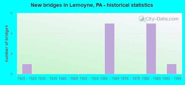
- New bridges - historical statistics
- 11920-1929
- 51960-1969
- 51980-1989
- 11990-1999

- Reconstructed bridges - Historical Statistics
- 11980-1989
- 01990-1999
- 02000-2009
- 12010-2019


- Bridge Condition - Deck
- 50.0%Good
- 50.0%Satisfactory

- Bridge Condition - Superstructure
- 33.3%Very good
- 16.7%Good
- 33.3%Satisfactory
- 16.7%Fair

- Bridge Condition - Substructure
- 16.7%Good
- 16.7%Satisfactory
- 66.7%Fair
Find on map >> Show street view
Structure Number: 13716, Location: LEMOYNE BORO (Lat: 40.238472, Lng: -76.895028), Route carried "on" structure: State highway 581, Year Built: 1960, Status: Open, Structure Length: 2.29m (7.51ft), Average Daily Traffic: 85,079 (year 2021), Truck Traffic: 9%, Average Future Daily Traffic: 74,895 (year 2032), Design Load: HS 20, Features Intersected: 83SB,8113 (Ramp to 581WB
Minimum Vertical Clearance: 30+ m (98+ ft), Kilometerpoint: 10.910, Lanes on structure: 4, Lanes under structure: 6, Base Highway Network: Yes, Owner: State Highway Agency, Approaching Roadway Width: 20.1m (65.9ft), Skew: 32 degrees, Material/Design: Concrete, Design/Construction: Frame, Number Of Spans In Main Unit: 1, Length of Maximum Span: 20.1m (65.9ft), Curb or Sidewalk Widths: Left: 0.2m (0.7ft), Right: 0.2m (0.7ft), Curb-To-Curb Width: 19.7m (64.6ft), Out-to-Out Width: 21.9m (71.9ft)
Condition: Deck: Satisfactory, Superstructure: Satisfactory, Substructure: Fair, Operating Rating: 61.7 metric tons, Method Used To Determine Operating Rating: Field evaluation and documented engineering judgment, Inventory Rating: 36.3 metric tons, Method Used To Determine Inventory Rating: Field evaluation and documented engineering judgment, Structural Evaluation: Somewhat better than minimum adequacy, Deck Geometry: Equal to present minimum criteria, Underclear: High priority of corrective action, Approach Roadway Alignment: Equal to present desirable criteria, Length Of Structure Improvement: 2.30m (7.55ft), Designated Inspection Frequency: Every 24 months, Inspection Date: June 2020, Bridge Improvement Cost: $59,000, Roadway Improvement Cost: $175,000, Total Project Cost: $801,000, Deck Structure Type: Concrete Cast-file-Place, Wearing Surface/Protective System: Wearing Surface: Latex Concrete
Find on map >> Show street view
Structure Number: 13718, Location: LEMOYNE BORO (Lat: 40.243706, Lng: -76.885769), Route carried "on" structure: Interstate 83, Year Built: 1982, Status: Open, Structure Length: 1.68m (5.51ft), Average Daily Traffic: 102,326 (year 2022), Truck Traffic: 13%, Average Future Daily Traffic: 112,131 (year 2032), Design Load: HS 20, Features Intersected: RAMP X STA 7+35
Minimum Vertical Clearance: 30+ m (98+ ft), Kilometerpoint: 3.016, Lanes on structure: 4, Lanes under structure: 1, Base Highway Network: Yes, Owner: State Highway Agency, Approaching Roadway Width: 32.6m (107.0ft), Skew: 34 degrees, Material/Design: Steel, Design/Construction: Stringer/Multi-beam, Number Of Spans In Main Unit: 1, Length of Maximum Span: 14.6m (47.9ft), Curb or Sidewalk Widths: Left: 0.2m (0.7ft), Right: 0.2m (0.7ft), Curb-To-Curb Width: 32.6m (107.0ft), Out-to-Out Width: 34.6m (113.5ft)
Condition: Deck: Satisfactory, Superstructure: Satisfactory, Substructure: Fair, Operating Rating: 98.0 metric tons, Method Used To Determine Operating Rating: Load Factor (LF), Inventory Rating: 58.1 metric tons, Method Used To Determine Inventory Rating: Load Factor (LF), Structural Evaluation: Somewhat better than minimum adequacy, Deck Geometry: Superior to present desirable criteria, Underclear: High priority of corrective action, Approach Roadway Alignment: Equal to present desirable criteria, Length Of Structure Improvement: 2.40m (7.87ft), Designated Inspection Frequency: Every 24 months, Inspection Date: June 2020, Deck Structure Type: Concrete Cast-file-Place, Wearing Surface/Protective System: Wearing Surface: Monolithic Concrete, Deck Protection: Epoxy Coated Reinforcing
Find on map >> Show street view
Structure Number: 13765, Location: LEMOYNE (Lat: 40.236964, Lng: -76.897514), Route carried "on" structure: State highway 581, Year Built: 1960, Year Reconstructed: 2015, Status: Open, Structure Length: 3.75m (12.30ft), Average Daily Traffic: 85,079 (year 2021), Truck Traffic: 9%, Average Future Daily Traffic: 110,987 (year 2032), Design Load: HS 20, Features Intersected: TENTH STREET
Minimum Vertical Clearance: 30+ m (98+ ft), Kilometerpoint: 10.910, Lanes on structure: 5, Lanes under structure: 2, Base Highway Network: Yes, Owner: State Highway Agency, Approaching Roadway Width: 23.8m (78.1ft), Skew: 31 degrees, Material/Design: Steel continuous, Design/Construction: Stringer/Multi-beam, Number Of Spans In Main Unit: 3, Length of Maximum Span: 14.3m (46.9ft), Curb or Sidewalk Widths: Left: 0.2m (0.7ft), Right: 0.2m (0.7ft), Curb-To-Curb Width: 24.2m (79.4ft), Out-to-Out Width: 26.1m (85.6ft)
Condition: Deck: Good, Superstructure: Very good, Substructure: Fair, Operating Rating: 98.9 metric tons, Method Used To Determine Operating Rating: Load Factor (LF), Inventory Rating: 59.0 metric tons, Method Used To Determine Inventory Rating: Load Factor (LF), Structural Evaluation: Somewhat better than minimum adequacy, Deck Geometry: Equal to present minimum criteria, Underclear: High priority of corrective action, Approach Roadway Alignment: Equal to present desirable criteria, Length Of Structure Improvement: 3.80m (12.47ft), Designated Inspection Frequency: Every 24 months, Inspection Date: June 2020, Bridge Improvement Cost: $98,000, Roadway Improvement Cost: $289,000, Total Project Cost: $1,323,000, Deck Structure Type: Concrete Cast-file-Place, Wearing Surface/Protective System: Wearing Surface: Latex Concrete, Deck Protection: Epoxy Coated Reinforcing
Find on map >> Show street view
Structure Number: 139, Location: LEMOYNE (Lat: 40.241900, Lng: -76.889122), Route carried "on" structure: State highway , Year Built: 1982, Status: Open, Structure Length: 3.66m (12.01ft), Average Daily Traffic: 15,537 (year 2021), Truck Traffic: 3%, Average Future Daily Traffic: 22,145 (year 2032), Design Load: HS 20, Features Intersected: I-83; SR 0083, Facility Carried by Structure: 2035 3rd St
Minimum Vertical Clearance: 30+ m (98+ ft), Kilometerpoint: 3.090, Lanes on structure: 2, Lanes under structure: 10, Base Highway Network: Yes, Owner: State Highway Agency, Approaching Roadway Width: 13.7m (44.9ft), Material/Design: Prestressed concrete, Design/Construction: Box Beam or Girders - Multiple, Number Of Spans In Main Unit: 2, Length of Maximum Span: 19.8m (65.0ft), Curb or Sidewalk Widths: Left: 1.5m (4.9ft), Right: 0.2m (0.7ft), Curb-To-Curb Width: 13.7m (44.9ft), Out-to-Out Width: 16.5m (54.1ft)
Condition: Deck: Satisfactory, Superstructure: Fair, Substructure: Satisfactory, Operating Rating: 89.8 metric tons, Method Used To Determine Operating Rating: Load Factor (LF), Inventory Rating: 42.6 metric tons, Method Used To Determine Inventory Rating: Load Factor (LF), Structural Evaluation: Somewhat better than minimum adequacy, Deck Geometry: Superior to present desirable criteria, Underclear: Meets minimum limits, Approach Roadway Alignment: Better than present minimum criteria, Length Of Structure Improvement: 4.60m (15.09ft), Designated Inspection Frequency: Every 24 months, Inspection Date: June 2020, Deck Structure Type: Concrete Cast-file-Place, Wearing Surface/Protective System: Wearing Surface: Monolithic Concrete, Deck Protection: Epoxy Coated Reinforcing
Find on map >> Show street view
Structure Number: 13901, Location: LEMOYNE BORO (Lat: 40.242108, Lng: -76.889392), Route carried "on" structure: State highway , Year Built: 1923, Year Reconstructed: 1991, Status: Open, Structure Length: 2.19m (7.19ft), Average Daily Traffic: 15,537 (year 2021), Truck Traffic: 3%, Average Future Daily Traffic: 22,145 (year 2035), Design Load: HS 25 or greater, Features Intersected: NORFOLK SO., Facility Carried by Structure: SR 2035
Minimum Vertical Clearance: 30+ m (98+ ft), Kilometerpoint: 3.090, Lanes on structure: 3, Base Highway Network: Yes, Owner: State Highway Agency, Approaching Roadway Width: 12.2m (40.0ft), Material/Design: Steel, Design/Construction: Stringer/Multi-beam, Number Of Spans In Main Unit: 1, Length of Maximum Span: 19.2m (63.0ft), Curb or Sidewalk Widths: Left: 1.6m (5.2ft), Right: 0.2m (0.7ft), Curb-To-Curb Width: 12.2m (40.0ft), Out-to-Out Width: 15.1m (49.5ft)
Condition: Deck: Good, Superstructure: Good, Substructure: Fair, Operating Rating: 73.5 metric tons, Method Used To Determine Operating Rating: Load Factor (LF), Inventory Rating: 43.5 metric tons, Method Used To Determine Inventory Rating: Load Factor (LF), Structural Evaluation: Somewhat better than minimum adequacy, Deck Geometry: Meets minimum limits, Underclear: High priority of corrective action, Approach Roadway Alignment: Better than present minimum criteria, Length Of Structure Improvement: 2.90m (9.51ft), Designated Inspection Frequency: Every 24 months, Inspection Date: Febuary 2020, Bridge Improvement Cost: $10,000, Roadway Improvement Cost: $30,000, Total Project Cost: $137,000, Deck Structure Type: Concrete Cast-file-Place, Wearing Surface/Protective System: Wearing Surface: Monolithic Concrete, Deck Protection: Epoxy Coated Reinforcing
Find on map >> Show street view
Structure Number: 40719, Location: 3rd St Lemoyne over RR (Lat: 40.245956, Lng: -76.893422), Route carried "on" structure: State highway , Year Built: 1999, Status: Open, Structure Length: 2.10m (6.89ft), Average Daily Traffic: 15,537 (year 2021), Truck Traffic: 3%, Average Future Daily Traffic: 22,145 (year 2032), Design Load: HS 25 or greater, Features Intersected: NORFOLK SO. R.R., Facility Carried by Structure: 2035 (3rd St)
Minimum Vertical Clearance: 30+ m (98+ ft), Kilometerpoint: 3.090, Lanes on structure: 3, Base Highway Network: Yes, Owner: State Highway Agency, Approaching Roadway Width: 12.2m (40.0ft), Material/Design: Prestressed concrete, Design/Construction: Box Beam or Girders - Multiple, Number Of Spans In Main Unit: 1, Length of Maximum Span: 21.0m (68.9ft), Curb or Sidewalk Widths: Left: 2.0m (6.6ft), Right: 2.0m (6.6ft), Curb-To-Curb Width: 12.2m (40.0ft), Out-to-Out Width: 16.9m (55.4ft)
Condition: Deck: Good, Superstructure: Very good, Substructure: Good, Operating Rating: 89.8 metric tons, Method Used To Determine Operating Rating: Load Factor (LF), Inventory Rating: 58.1 metric tons, Method Used To Determine Inventory Rating: Load Factor (LF), Structural Evaluation: Better than present minimum criteria, Deck Geometry: Meets minimum limits, Underclear: High priority of corrective action, Approach Roadway Alignment: Better than present minimum criteria, Length Of Structure Improvement: 2.80m (9.19ft), Designated Inspection Frequency: Every 24 months, Inspection Date: June 2020, Deck Structure Type: Concrete Cast-file-Place, Wearing Surface/Protective System: Wearing Surface: Monolithic Concrete, Deck Protection: Epoxy Coated Reinforcing
Find on map >> Show street view
Structure Number: 13716, Location: LEMOYNE BORO (Lat: 40.238472, Lng: -76.895028), Route carried "under" structure: Interstate 83, Year Built: 1960, Structure Length: 0. m, Average Daily Traffic: 38,694 (year 2021), Truck Traffic: 15%, Features Intersected: 83SB,8113 (Ramp to 581WB, Facility Carried by Structure: PA 581
Minimum Vertical Clearance: 4.75m (15.58ft), Kilometerpoint: 2.210, Lanes on structure: 4, Lanes under structure: 3, Material/Design: Concrete, Design/Construction: Frame, Length of Maximum Span: 20.1m (65.9ft)
Find on map >> Show street view
Structure Number: 13716, Location: LEMOYNE BORO (Lat: 40.238472, Lng: -76.895028), Route carried "under" structure: Ramp State highway , Year Built: 1960, Structure Length: 0. m, Average Daily Traffic: 13,396 (year 2021), Truck Traffic: 7%, Features Intersected: 83SB,8113 (Ramp to 581WB, Facility Carried by Structure: PA 581
Minimum Vertical Clearance: 4.70m (15.42ft), Kilometerpoint: 0.000, Lanes on structure: 4, Lanes under structure: 3, Material/Design: Concrete, Design/Construction: Frame, Length of Maximum Span: 20.1m (65.9ft)
Find on map >> Show street view
Structure Number: 13718, Location: LEMOYNE BORO (Lat: 40.243706, Lng: -76.885769), Route carried "under" structure: Ramp State highway , Year Built: 1982, Structure Length: 0. m, Average Daily Traffic: 6,826 (year 2021), Truck Traffic: 7%, Features Intersected: RAMP X STA 7+35, Facility Carried by Structure: I-83; SR 0083
Minimum Vertical Clearance: 4.54m (14.90ft), Kilometerpoint: 0.000, Lanes on structure: 4, Lanes under structure: 1, Material/Design: Steel, Design/Construction: Stringer/Multi-beam, Length of Maximum Span: 14.6m (47.9ft)
Find on map >> Show street view
Structure Number: 13765, Location: LEMOYNE (Lat: 40.236964, Lng: -76.897514), Route carried "under" structure: City street , Year Built: 1960, Structure Length: 0. m, Average Daily Traffic: 20,000 (year 1983), Truck Traffic: 2%, Features Intersected: TENTH STREET, Facility Carried by Structure: ServiceCity street 1
Minimum Vertical Clearance: 4.44m (14.57ft), Kilometerpoint: 0.000, Lanes on structure: 5, Lanes under structure: 2, Material/Design: Steel continuous, Design/Construction: Stringer/Multi-beam, Length of Maximum Span: 14.3m (46.9ft)
Find on map >> Show street view
Structure Number: 139, Location: LEMOYNE (Lat: 40.241900, Lng: -76.889122), Route carried "under" structure: Interstate 83, Year Built: 1982, Structure Length: 0. m, Average Daily Traffic: 51,408 (year 2022), Truck Traffic: 16%, Features Intersected: I-83; SR 0083, Facility Carried by Structure: 2035 3rd St
Minimum Vertical Clearance: 5.15m (16.90ft), Kilometerpoint: 3.016, Lanes on structure: 2, Lanes under structure: 5, Material/Design: Prestressed concrete, Design/Construction: Box Beam or Girders - Multiple, Length of Maximum Span: 19.8m (65.0ft)
Find on map >> Show street view
Structure Number: 139, Location: LEMOYNE (Lat: 40.241900, Lng: -76.889122), Route carried "under" structure: Interstate 83, Year Built: 1982, Structure Length: 0. m, Average Daily Traffic: 50,918 (year 2022), Truck Traffic: 10%, Features Intersected: I-83; SR 0083, Facility Carried by Structure: 2035 3rd St
Minimum Vertical Clearance: 5.82m (19.09ft), Kilometerpoint: 3.137, Lanes on structure: 2, Lanes under structure: 5, Material/Design: Prestressed concrete, Design/Construction: Box Beam or Girders - Multiple, Length of Maximum Span: 19.8m (65.0ft)