Bridge Statistics for Lemonweir, Wisconsin (WI)
Condition, Traffic, Stress, Structural Evaluation, Project Costs
- National Bridge Inventory (NBI) Statistics
- 30Number of bridges
- 335ft / 102mTotal length
- $341,000Total costs
- 265,080Total average daily traffic
- 45,207Total average daily truck traffic
- National Bridge Inventory (NBI) Registered Bridges for Lemonweir
- No street view available for this location
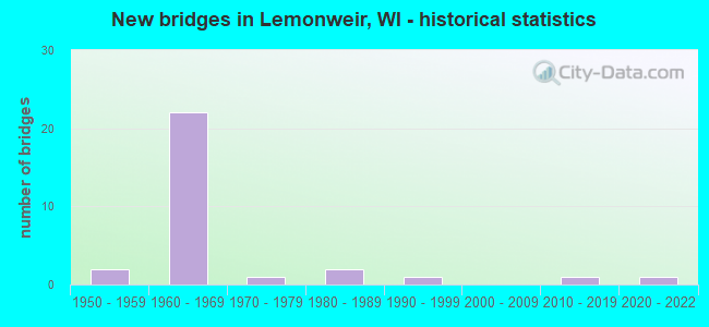
- New bridges - historical statistics
- 21950-1959
- 221960-1969
- 11970-1979
- 21980-1989
- 11990-1999
- 12010-2019
- 12020-2022

- Reconstructed bridges - Historical Statistics
- 51980-1989
- 41990-1999
- 22000-2009


- Bridge Condition - Deck
- 5.0%Very good
- 30.0%Good
- 55.0%Satisfactory
- 10.0%Fair

- Bridge Condition - Superstructure
- 10.0%Very good
- 15.0%Good
- 45.0%Satisfactory
- 30.0%Fair

- Bridge Condition - Substructure
- 20.0%Very good
- 25.0%Good
- 45.0%Satisfactory
- 10.0%Fair

- Bridge Condition - Channel
- 10.0%Excellent
- 50.0%Very good
- 40.0%Good
Find on map >> Show street view
Structure Number: B290006, Location: 0.1M E JCT STH 80 (Lat: 44.026797, Lng: -90.072497), Route carried "on" structure: State highway 21, Year Built: 1950, Year Reconstructed: 1999, Status: Open, Structure Length: 7.47m (24.51ft), Average Daily Traffic: 6,900 (year 2019), Truck Traffic: 8%, Average Future Daily Traffic: 11,710 (year 2040), Design Load: HS 20, Features Intersected: YELLOW RIVER
Minimum Vertical Clearance: 30+ m (98+ ft), Kilometerpoint: 0.000, Lanes on structure: 2, Base Highway Network: Yes, Owner: State Highway Agency, Approaching Roadway Width: 11.6m (38.1ft), Material/Design: Steel continuous, Design/Construction: Stringer/Multi-beam, Number Of Spans In Main Unit: 3, Length of Maximum Span: 28.0m (91.9ft), Curb or Sidewalk Widths: Left: 0.0m, Right: 2.0m (6.6ft), Curb-To-Curb Width: 8.6m (28.2ft), Out-to-Out Width: 10.8m (35.4ft)
Condition: Deck: Good, Superstructure: Satisfactory, Substructure: Satisfactory, Channel: Very good, Operating Rating: 52.3 metric tons, Method Used To Determine Operating Rating: Load Factor (LF), Inventory Rating: 30.8 metric tons, Method Used To Determine Inventory Rating: Load Factor (LF), Structural Evaluation: Equal to present minimum criteria, Deck Geometry: Meets minimum limits, Waterway Adequacy: Equal to present desirable criteria, Approach Roadway Alignment: Equal to present desirable criteria, Designated Inspection Frequency: Every 24 months, Underwater Inspection Frequency: Every 60 months, Inspection Date: May 2021, Underwater Inspection Date: August 2021, Deck Structure Type: Concrete Cast-file-Place, Wearing Surface/Protective System: Wearing Surface: Integral Concrete, Deck Protection: Epoxy Coated Reinforcing
Find on map >> Show street view
Structure Number: B290007, Location: 0.9M E JCT STH 82 TO E (Lat: 43.787436, Lng: -90.060167), Route carried "on" structure: US 12, Year Built: 1950, Year Reconstructed: 1988, Status: Open, Structure Length: 7.22m (23.69ft), Average Daily Traffic: 3,200 (year 2019), Truck Traffic: 4%, Average Future Daily Traffic: 4,770 (year 2040), Design Load: H 20, Features Intersected: CP RR
Minimum Vertical Clearance: 30+ m (98+ ft), Kilometerpoint: 0.000, Lanes on structure: 2, Owner: State Highway Agency, Approaching Roadway Width: 11.3m (37.1ft), Skew: 3 degrees, Material/Design: Steel continuous, Design/Construction: Stringer/Multi-beam, Number Of Spans In Main Unit: 3, Length of Maximum Span: 28.0m (91.9ft), Curb-To-Curb Width: 8.7m (28.5ft), Out-to-Out Width: 9.6m (31.5ft)
Condition: Deck: Fair, Superstructure: Satisfactory, Substructure: Satisfactory, Operating Rating: 62.1 metric tons, Method Used To Determine Operating Rating: Load Factor (LF), Inventory Rating: 37.3 metric tons, Method Used To Determine Inventory Rating: Load Factor (LF), Structural Evaluation: Equal to present minimum criteria, Deck Geometry: Meets minimum limits, Underclear: Equal to present minimum criteria, Approach Roadway Alignment: Equal to present desirable criteria, Designated Inspection Frequency: Every 24 months, Inspection Date: May 2021, Deck Structure Type: Concrete Cast-file-Place, Wearing Surface/Protective System: Wearing Surface: Monolithic Concrete, Deck Protection: Epoxy Coated Reinforcing
Find on map >> Show street view
Structure Number: B29002, Location: 2.6M E JCT USH 12 (Lat: 43.680717, Lng: -89.836911), Route carried "on" structure: City street , Year Built: 1964, Status: Open, Structure Length: 7.36m (24.15ft), Average Daily Traffic: 430 (year 2019), Average Future Daily Traffic: 270 (year 2040), Design Load: H 15, Features Intersected: IH 90-IH 94, Facility Carried by Structure: LRD 63RD ST
Minimum Vertical Clearance: 30+ m (98+ ft), Kilometerpoint: 0.000, Lanes on structure: 2, Lanes under structure: 4, Owner: State Highway Agency, Approaching Roadway Width: 7.9m (25.9ft), Skew: 2 degrees, Material/Design: Steel continuous, Design/Construction: Stringer/Multi-beam, Number Of Spans In Main Unit: 4, Length of Maximum Span: 23.3m (76.4ft), Curb-To-Curb Width: 7.3m (24.0ft), Out-to-Out Width: 8.5m (27.9ft)
Condition: Deck: Satisfactory, Superstructure: Fair, Substructure: Satisfactory, Operating Rating: 29.4 metric tons, Method Used To Determine Operating Rating: Load Factor (LF), Inventory Rating: 17.8 metric tons, Method Used To Determine Inventory Rating: Load Factor (LF), Structural Evaluation: Somewhat better than minimum adequacy, Deck Geometry: Meets minimum limits, Underclear: Somewhat better than minimum adequacy, Approach Roadway Alignment: Equal to present desirable criteria, Designated Inspection Frequency: Every 24 months, Inspection Date: April 2021, Deck Structure Type: Concrete Cast-file-Place, Wearing Surface/Protective System: Wearing Surface: Monolithic Concrete
Find on map >> Show street view
Structure Number: B290025, Location: 4.8M W JCT USH 12 (Lat: 43.762344, Lng: -89.975114), Route carried "on" structure: County highway , Year Built: 1964, Year Reconstructed: 2008, Status: Open, Structure Length: 7.22m (23.69ft), Average Daily Traffic: 290 (year 2019), Average Future Daily Traffic: 280 (year 2040), Design Load: H 15, Features Intersected: IH 90-IH 94, Facility Carried by Structure: CTH N
Minimum Vertical Clearance: 30+ m (98+ ft), Kilometerpoint: 0.000, Lanes on structure: 2, Lanes under structure: 4, Owner: State Highway Agency, Approaching Roadway Width: 8.5m (27.9ft), Skew: 2 degrees, Material/Design: Steel continuous, Design/Construction: Stringer/Multi-beam, Number Of Spans In Main Unit: 4, Length of Maximum Span: 22.6m (74.1ft), Curb-To-Curb Width: 8.4m (27.6ft), Out-to-Out Width: 9.1m (29.9ft)
Condition: Deck: Good, Superstructure: Satisfactory, Substructure: Satisfactory, Operating Rating: 49.0 metric tons, Method Used To Determine Operating Rating: Load Factor (LF), Inventory Rating: 21.1 metric tons, Method Used To Determine Inventory Rating: Load Factor (LF), Structural Evaluation: Equal to present minimum criteria, Deck Geometry: Somewhat better than minimum adequacy, Underclear: Somewhat better than minimum adequacy, Approach Roadway Alignment: Equal to present desirable criteria, Designated Inspection Frequency: Every 24 months, Inspection Date: April 2021, Deck Structure Type: Concrete Cast-file-Place, Wearing Surface/Protective System: Wearing Surface: Monolithic Concrete, Deck Protection: Epoxy Coated Reinforcing
Find on map >> Show street view
Structure Number: B290026, Location: 0.6M W JCT CTH N (Lat: 43.766311, Lng: -89.989119), Route carried "on" structure: City street , Year Built: 1964, Status: Open, Structure Length: 9.17m (30.09ft), Average Daily Traffic: 330 (year 2019), Average Future Daily Traffic: 250 (year 2040), Design Load: H 15, Features Intersected: IH 90-IH 94, Facility Carried by Structure: LRD 55TH ST/CEMETE
Minimum Vertical Clearance: 30+ m (98+ ft), Kilometerpoint: 0.000, Lanes on structure: 2, Lanes under structure: 4, Owner: State Highway Agency, Approaching Roadway Width: 8.5m (27.9ft), Skew: 4 degrees, Material/Design: Steel continuous, Design/Construction: Stringer/Multi-beam, Number Of Spans In Main Unit: 4, Length of Maximum Span: 29.1m (95.5ft), Curb-To-Curb Width: 7.3m (24.0ft), Out-to-Out Width: 8.5m (27.9ft)
Condition: Deck: Good, Superstructure: Satisfactory, Substructure: Good, Operating Rating: 49.0 metric tons, Method Used To Determine Operating Rating: Load Factor (LF), Inventory Rating: 22.7 metric tons, Method Used To Determine Inventory Rating: Load Factor (LF), Structural Evaluation: Equal to present minimum criteria, Deck Geometry: Somewhat better than minimum adequacy, Underclear: Somewhat better than minimum adequacy, Approach Roadway Alignment: Equal to present desirable criteria, Designated Inspection Frequency: Every 24 months, Inspection Date: April 2021, Deck Structure Type: Concrete Cast-file-Place, Wearing Surface/Protective System: Wearing Surface: Low Slump Concrete
Find on map >> Show street view
Structure Number: B290027, Location: 0.6M S JCT CTH N (Lat: 43.775397, Lng: -90.016742), Route carried "on" structure: City street , Year Built: 1964, Status: Open, Structure Length: 3.94m (12.93ft), Average Daily Traffic: 330 (year 2019), Average Future Daily Traffic: 250 (year 2040), Design Load: H 15, Features Intersected: IH 90 EB-IH 94 EB, Facility Carried by Structure: LRD 19TH AVE
Minimum Vertical Clearance: 30+ m (98+ ft), Kilometerpoint: 0.000, Lanes on structure: 2, Lanes under structure: 2, Owner: State Highway Agency, Approaching Roadway Width: 8.5m (27.9ft), Skew: 2 degrees, Material/Design: Concrete continuous, Design/Construction: Slab, Number Of Spans In Main Unit: 3, Length of Maximum Span: 15.5m (50.9ft), Curb-To-Curb Width: 7.3m (24.0ft), Out-to-Out Width: 8.5m (27.9ft)
Condition: Deck: Satisfactory, Superstructure: Satisfactory, Substructure: Good, Operating Rating: 33.0 metric tons, Method Used To Determine Operating Rating: Load Factor (LF), Inventory Rating: 19.4 metric tons, Method Used To Determine Inventory Rating: Load Factor (LF), Structural Evaluation: Somewhat better than minimum adequacy, Deck Geometry: Somewhat better than minimum adequacy, Underclear: Meets minimum limits, Approach Roadway Alignment: Equal to present desirable criteria, Designated Inspection Frequency: Every 24 months, Inspection Date: April 2021, Deck Structure Type: Concrete Cast-file-Place, Wearing Surface/Protective System: Wearing Surface: Bituminous
Find on map >> Show street view
Structure Number: B290028, Location: 0.6M S JCT CTH N (Lat: 43.775397, Lng: -90.016742), Route carried "on" structure: City street , Year Built: 1964, Status: Open, Structure Length: 3.94m (12.93ft), Average Daily Traffic: 200 (year 2019), Average Future Daily Traffic: 250 (year 2040), Design Load: H 15, Features Intersected: IH 90 WB-IH 94 WB, Facility Carried by Structure: LRD 19TH AVE
Minimum Vertical Clearance: 30+ m (98+ ft), Kilometerpoint: 0.000, Lanes on structure: 2, Lanes under structure: 2, Owner: State Highway Agency, Approaching Roadway Width: 8.5m (27.9ft), Skew: 2 degrees, Material/Design: Concrete continuous, Design/Construction: Slab, Number Of Spans In Main Unit: 3, Length of Maximum Span: 15.5m (50.9ft), Curb-To-Curb Width: 7.3m (24.0ft), Out-to-Out Width: 8.5m (27.9ft)
Condition: Deck: Satisfactory, Superstructure: Satisfactory, Substructure: Good, Operating Rating: 33.0 metric tons, Method Used To Determine Operating Rating: Load Factor (LF), Inventory Rating: 19.4 metric tons, Method Used To Determine Inventory Rating: Load Factor (LF), Structural Evaluation: Somewhat better than minimum adequacy, Deck Geometry: Somewhat better than minimum adequacy, Underclear: Meets minimum limits, Approach Roadway Alignment: Equal to present desirable criteria, Designated Inspection Frequency: Every 24 months, Inspection Date: April 2021, Deck Structure Type: Concrete Cast-file-Place, Wearing Surface/Protective System: Wearing Surface: Bituminous
Find on map >> Show street view
Structure Number: B290029, Location: 3.5M E JCT STH 82 TO E (Lat: 43.771025, Lng: -90.003758), Route carried "on" structure: Interstate 90, Year Built: 1964, Year Reconstructed: 1994, Status: Open, Structure Length: 0.85m (2.79ft), Average Daily Traffic: 17,350 (year 2019), Truck Traffic: 27%, Average Future Daily Traffic: 29,600 (year 2040), Design Load: HS 20+Mod, Features Intersected: SEVEN MILE CREEK
Minimum Vertical Clearance: 30+ m (98+ ft), Kilometerpoint: 0.000, Lanes on structure: 2, Base Highway Network: Yes, Owner: State Highway Agency, Approaching Roadway Width: 12.2m (40.0ft), Skew: 1 degrees, Material/Design: Concrete continuous, Design/Construction: Culvert, Number Of Spans In Main Unit: 2, Length of Maximum Span: 3.7m (12.1ft)
Condition: Channel: Good, Culverts: Good, Operating Rating: 53.9 metric tons, Method Used To Determine Operating Rating: Field evaluation and documented engineering judgment, Inventory Rating: 32.4 metric tons, Method Used To Determine Inventory Rating: Field evaluation and documented engineering judgment, Structural Evaluation: Better than present minimum criteria, Waterway Adequacy: Equal to present desirable criteria, Approach Roadway Alignment: Equal to present desirable criteria, Designated Inspection Frequency: Every 24 months, Inspection Date: April 2021, Deck Structure Type: Concrete Cast-file-Place, Wearing Surface/Protective System: Wearing Surface: Bituminous
Find on map >> Show street view
Structure Number: B290031, Location: 0.6M E JCT USH 12 (Lat: 43.784439, Lng: -90.044344), Route carried "on" structure: County highway , Year Built: 1964, Year Reconstructed: 2008, Status: Open, Structure Length: 9.09m (29.82ft), Average Daily Traffic: 330 (year 2019), Average Future Daily Traffic: 300 (year 2040), Design Load: H 15, Features Intersected: IH 90/94, Facility Carried by Structure: CTH N
Minimum Vertical Clearance: 30+ m (98+ ft), Kilometerpoint: 0.000, Lanes on structure: 2, Lanes under structure: 4, Owner: State Highway Agency, Approaching Roadway Width: 8.5m (27.9ft), Skew: 4 degrees, Material/Design: Steel continuous, Design/Construction: Stringer/Multi-beam, Number Of Spans In Main Unit: 4, Length of Maximum Span: 29.0m (95.1ft), Curb-To-Curb Width: 8.4m (27.6ft), Out-to-Out Width: 9.1m (29.9ft)
Condition: Deck: Good, Superstructure: Fair, Substructure: Satisfactory, Operating Rating: 52.3 metric tons, Method Used To Determine Operating Rating: Load Factor (LF), Inventory Rating: 22.7 metric tons, Method Used To Determine Inventory Rating: Load Factor (LF), Structural Evaluation: Somewhat better than minimum adequacy, Deck Geometry: Somewhat better than minimum adequacy, Underclear: Somewhat better than minimum adequacy, Approach Roadway Alignment: Equal to present desirable criteria, Designated Inspection Frequency: Every 24 months, Inspection Date: April 2021, Deck Structure Type: Concrete Cast-file-Place, Wearing Surface/Protective System: Wearing Surface: Monolithic Concrete, Deck Protection: Epoxy Coated Reinforcing
Find on map >> Show street view
Structure Number: B290032, Location: 0.7M E JCT STH 82 TO E (Lat: 43.789811, Lng: -90.050719), Route carried "on" structure: Interstate 90, Year Built: 1964, Year Reconstructed: 1994, Status: Open, Structure Length: 6.19m (20.31ft), Average Daily Traffic: 14,400 (year 2020), Truck Traffic: 27%, Average Future Daily Traffic: 29,600 (year 2040), Design Load: HS 20+Mod, Features Intersected: LEMONWEIR RIVER
Minimum Vertical Clearance: 30+ m (98+ ft), Kilometerpoint: 0.000, Lanes on structure: 2, Base Highway Network: Yes, Owner: State Highway Agency, Approaching Roadway Width: 12.2m (40.0ft), Skew: 1 degrees, Material/Design: Prestressed concrete, Design/Construction: Stringer/Multi-beam, Number Of Spans In Main Unit: 3, Length of Maximum Span: 20.4m (66.9ft), Curb-To-Curb Width: 12.2m (40.0ft), Out-to-Out Width: 13.1m (43.0ft)
Condition: Deck: Satisfactory, Superstructure: Fair, Substructure: Fair, Channel: Good, Operating Rating: 57.0 metric tons, Method Used To Determine Operating Rating: Load Factor (LF), Inventory Rating: 35.6 metric tons, Method Used To Determine Inventory Rating: Load Factor (LF), Structural Evaluation: Somewhat better than minimum adequacy, Deck Geometry: Better than present minimum criteria, Waterway Adequacy: Equal to present desirable criteria, Approach Roadway Alignment: Equal to present desirable criteria, Designated Inspection Frequency: Every 24 months, Underwater Inspection Frequency: Every 60 months, Inspection Date: April 2021, Underwater Inspection Date: August 2019, Deck Structure Type: Concrete Cast-file-Place, Wearing Surface/Protective System: Wearing Surface: Epoxy Overlay, Deck Protection: Epoxy Coated Reinforcing
Find on map >> Show street view
Structure Number: B290033, Location: 9.5M W JCT CTH HH TO N (Lat: 43.789503, Lng: -90.049844), Route carried "on" structure: Interstate 90, Year Built: 1964, Year Reconstructed: 1995, Status: Open, Structure Length: 6.19m (20.31ft), Average Daily Traffic: 14,400 (year 2020), Truck Traffic: 14%, Average Future Daily Traffic: 25,215 (year 2040), Design Load: HS 20+Mod, Features Intersected: LEMONWIER RIVER
Minimum Vertical Clearance: 30+ m (98+ ft), Kilometerpoint: 0.000, Lanes on structure: 2, Base Highway Network: Yes, Owner: State Highway Agency, Approaching Roadway Width: 12.2m (40.0ft), Skew: 1 degrees, Material/Design: Prestressed concrete, Design/Construction: Stringer/Multi-beam, Number Of Spans In Main Unit: 3, Length of Maximum Span: 20.4m (66.9ft), Curb-To-Curb Width: 12.2m (40.0ft), Out-to-Out Width: 13.1m (43.0ft)
Condition: Deck: Satisfactory, Superstructure: Fair, Substructure: Fair, Channel: Very good, Operating Rating: 57.0 metric tons, Method Used To Determine Operating Rating: Load Factor (LF), Inventory Rating: 35.6 metric tons, Method Used To Determine Inventory Rating: Load Factor (LF), Structural Evaluation: Somewhat better than minimum adequacy, Deck Geometry: Better than present minimum criteria, Waterway Adequacy: Equal to present desirable criteria, Approach Roadway Alignment: Equal to present desirable criteria, Designated Inspection Frequency: Every 24 months, Underwater Inspection Frequency: Every 60 months, Inspection Date: April 2021, Underwater Inspection Date: August 2019, Deck Structure Type: Concrete Cast-file-Place, Wearing Surface/Protective System: Wearing Surface: Epoxy Overlay, Deck Protection: Epoxy Coated Reinforcing
Find on map >> Show street view
Structure Number: B290034, Location: 7.7M E JCT STH 80 TO N (Lat: 43.796653, Lng: -90.056986), Route carried "on" structure: Interstate 90, Year Built: 1964, Year Reconstructed: 1994, Status: Open, Structure Length: 6.14m (20.14ft), Average Daily Traffic: 14,400 (year 2020), Truck Traffic: 27%, Average Future Daily Traffic: 29,050 (year 2040), Design Load: HS 20+Mod, Features Intersected: STH 82
Minimum Vertical Clearance: 30+ m (98+ ft), Kilometerpoint: 0.000, Lanes on structure: 2, Lanes under structure: 4, Base Highway Network: Yes, Owner: State Highway Agency, Approaching Roadway Width: 12.2m (40.0ft), Skew: 3 degrees, Material/Design: Steel continuous, Design/Construction: Stringer/Multi-beam, Number Of Spans In Main Unit: 4, Length of Maximum Span: 18.6m (61.0ft), Curb-To-Curb Width: 12.2m (40.0ft), Out-to-Out Width: 13.1m (43.0ft)
Condition: Deck: Satisfactory, Superstructure: Fair, Substructure: Satisfactory, Operating Rating: 55.5 metric tons, Method Used To Determine Operating Rating: Load Factor (LF), Inventory Rating: 32.4 metric tons, Method Used To Determine Inventory Rating: Load Factor (LF), Structural Evaluation: Somewhat better than minimum adequacy, Deck Geometry: Better than present minimum criteria, Underclear: Meets minimum limits, Approach Roadway Alignment: Equal to present desirable criteria, Designated Inspection Frequency: Every 24 months, Inspection Date: May 2021, Deck Structure Type: Concrete Cast-file-Place, Wearing Surface/Protective System: Wearing Surface: Monolithic Concrete, Deck Protection: Epoxy Coated Reinforcing
Find on map >> Show street view
Structure Number: B290035, Location: 10.0M W JCT CTH HH TO N (Lat: 43.796197, Lng: -90.055989), Route carried "on" structure: Interstate 90, Year Built: 1964, Year Reconstructed: 1995, Status: Open, Structure Length: 6.14m (20.14ft), Average Daily Traffic: 14,400 (year 2020), Truck Traffic: 14%, Average Future Daily Traffic: 25,215 (year 2040), Design Load: HS 20+Mod, Features Intersected: STH 82
Minimum Vertical Clearance: 30+ m (98+ ft), Kilometerpoint: 0.000, Lanes on structure: 2, Lanes under structure: 4, Base Highway Network: Yes, Owner: State Highway Agency, Approaching Roadway Width: 12.2m (40.0ft), Skew: 3 degrees, Material/Design: Steel continuous, Design/Construction: Stringer/Multi-beam, Number Of Spans In Main Unit: 4, Length of Maximum Span: 18.6m (61.0ft), Curb-To-Curb Width: 12.2m (40.0ft), Out-to-Out Width: 13.1m (43.0ft)
Condition: Deck: Satisfactory, Superstructure: Satisfactory, Substructure: Satisfactory, Operating Rating: 53.9 metric tons, Method Used To Determine Operating Rating: Load Factor (LF), Inventory Rating: 32.4 metric tons, Method Used To Determine Inventory Rating: Load Factor (LF), Structural Evaluation: Equal to present minimum criteria, Deck Geometry: Better than present minimum criteria, Underclear: Meets minimum limits, Approach Roadway Alignment: Equal to present desirable criteria, Designated Inspection Frequency: Every 24 months, Inspection Date: May 2021, Deck Structure Type: Concrete Cast-file-Place, Wearing Surface/Protective System: Wearing Surface: Monolithic Concrete, Deck Protection: Epoxy Coated Reinforcing
Find on map >> Show street view
Structure Number: B290036, Location: 7.1M E JCT STH 80 TO N (Lat: 43.803689, Lng: -90.063836), Route carried "on" structure: Interstate 90, Year Built: 1964, Year Reconstructed: 1994, Status: Open, Structure Length: 4.43m (14.53ft), Average Daily Traffic: 14,400 (year 2020), Truck Traffic: 27%, Average Future Daily Traffic: 29,050 (year 2040), Design Load: HS 20+Mod, Features Intersected: CTH G
Minimum Vertical Clearance: 30+ m (98+ ft), Kilometerpoint: 0.000, Lanes on structure: 2, Lanes under structure: 2, Base Highway Network: Yes, Owner: State Highway Agency, Approaching Roadway Width: 12.2m (40.0ft), Skew: 3 degrees, Material/Design: Steel continuous, Design/Construction: Stringer/Multi-beam, Number Of Spans In Main Unit: 3, Length of Maximum Span: 17.8m (58.4ft), Curb-To-Curb Width: 12.2m (40.0ft), Out-to-Out Width: 13.1m (43.0ft)
Condition: Deck: Satisfactory, Superstructure: Satisfactory, Substructure: Satisfactory, Operating Rating: 52.3 metric tons, Method Used To Determine Operating Rating: Load Factor (LF), Inventory Rating: 30.8 metric tons, Method Used To Determine Inventory Rating: Load Factor (LF), Structural Evaluation: Equal to present minimum criteria, Deck Geometry: Better than present minimum criteria, Underclear: Equal to present minimum criteria, Approach Roadway Alignment: Equal to present desirable criteria, Designated Inspection Frequency: Every 24 months, Inspection Date: May 2021, Deck Structure Type: Concrete Cast-file-Place, Wearing Surface/Protective System: Wearing Surface: Monolithic Concrete, Deck Protection: Epoxy Coated Reinforcing
Find on map >> Show street view
Structure Number: B290037, Location: 0.7M W JCT STH 82 TO E (Lat: 43.803378, Lng: -90.062900), Route carried "on" structure: Interstate 90, Year Built: 1964, Year Reconstructed: 1995, Status: Open, Structure Length: 4.43m (14.53ft), Average Daily Traffic: 14,400 (year 2020), Truck Traffic: 27%, Average Future Daily Traffic: 29,050 (year 2040), Design Load: HS 20+Mod, Features Intersected: CTH G
Minimum Vertical Clearance: 30+ m (98+ ft), Kilometerpoint: 0.000, Lanes on structure: 2, Lanes under structure: 2, Base Highway Network: Yes, Owner: State Highway Agency, Approaching Roadway Width: 12.2m (40.0ft), Skew: 3 degrees, Material/Design: Steel continuous, Design/Construction: Stringer/Multi-beam, Number Of Spans In Main Unit: 3, Length of Maximum Span: 17.8m (58.4ft), Curb-To-Curb Width: 12.2m (40.0ft), Out-to-Out Width: 13.1m (43.0ft)
Condition: Deck: Satisfactory, Superstructure: Satisfactory, Substructure: Satisfactory, Operating Rating: 52.3 metric tons, Method Used To Determine Operating Rating: Load Factor (LF), Inventory Rating: 30.8 metric tons, Method Used To Determine Inventory Rating: Load Factor (LF), Structural Evaluation: Equal to present minimum criteria, Deck Geometry: Better than present minimum criteria, Underclear: Better than present minimum criteria, Approach Roadway Alignment: Equal to present desirable criteria, Designated Inspection Frequency: Every 24 months, Inspection Date: May 2021, Deck Structure Type: Concrete Cast-file-Place, Wearing Surface/Protective System: Wearing Surface: Monolithic Concrete, Deck Protection: Epoxy Coated Reinforcing
Find on map >> Show street view
Structure Number: B290064, Location: 0.5M E JCT CTH K (Lat: 43.778867, Lng: -90.057389), Route carried "on" structure: US 12, Year Built: 1973, Status: Open, Structure Length: 2.65m (8.69ft), Average Daily Traffic: 3,200 (year 2019), Truck Traffic: 4%, Average Future Daily Traffic: 3,420 (year 2040), Design Load: HS 20, Features Intersected: ONE MILE CREEK
Minimum Vertical Clearance: 30+ m (98+ ft), Kilometerpoint: 0.000, Lanes on structure: 2, Owner: State Highway Agency, Approaching Roadway Width: 13.4m (44.0ft), Skew: 2 degrees, Material/Design: Prestressed concrete, Design/Construction: Stringer/Multi-beam, Number Of Spans In Main Unit: 1, Length of Maximum Span: 25.8m (84.6ft), Curb-To-Curb Width: 13.4m (44.0ft), Out-to-Out Width: 14.6m (47.9ft)
Condition: Deck: Satisfactory, Superstructure: Very good, Substructure: Good, Channel: Good, Operating Rating: 86.5 metric tons, Method Used To Determine Operating Rating: Load Factor (LF), Inventory Rating: 38.9 metric tons, Method Used To Determine Inventory Rating: Load Factor (LF), Structural Evaluation: Better than present minimum criteria, Deck Geometry: Better than present minimum criteria, Waterway Adequacy: Equal to present desirable criteria, Approach Roadway Alignment: Equal to present desirable criteria, Designated Inspection Frequency: Every 24 months, Inspection Date: May 2021, Deck Structure Type: Concrete Cast-file-Place, Wearing Surface/Protective System: Wearing Surface: Low Slump Concrete
Find on map >> Show street view
Structure Number: B290082, Location: 0.1M E JCT USH 12 (Lat: 43.786944, Lng: -90.063222), Route carried "on" structure: County highway , Year Built: 1988, Status: Open, Structure Length: 1.00m (3.28ft), Average Daily Traffic: 343 (year 2019), Average Future Daily Traffic: 377 (year 2040), Design Load: HS 20, Features Intersected: LEMONWEIR RIVER SLOUGH, Facility Carried by Structure: CTH N
Minimum Vertical Clearance: 30+ m (98+ ft), Kilometerpoint: 0.000, Lanes on structure: 2, Owner: County Highway Agency, Approaching Roadway Width: 9.1m (29.9ft), Material/Design: Concrete, Design/Construction: Slab, Number Of Spans In Main Unit: 1, Length of Maximum Span: 9.4m (30.8ft), Curb-To-Curb Width: 8.5m (27.9ft), Out-to-Out Width: 9.1m (29.9ft)
Condition: Deck: Fair, Superstructure: Fair, Substructure: Very good, Channel: Very good, Operating Rating: 53.9 metric tons, Method Used To Determine Operating Rating: Load Factor (LF), Inventory Rating: 32.4 metric tons, Method Used To Determine Inventory Rating: Load Factor (LF), Structural Evaluation: Somewhat better than minimum adequacy, Deck Geometry: Equal to present minimum criteria, Waterway Adequacy: Equal to present desirable criteria, Approach Roadway Alignment: Equal to present desirable criteria, Designated Inspection Frequency: Every 24 months, Inspection Date: May 2021, Deck Structure Type: Concrete Cast-file-Place, Wearing Surface/Protective System: Wearing Surface: Monolithic Concrete, Deck Protection: Epoxy Coated Reinforcing
Find on map >> Show street view
Structure Number: B290085, Location: 0.3M E JCT USH 12 (Lat: 43.785128, Lng: -90.054069), Route carried "on" structure: County highway , Year Built: 1988, Status: Open, Structure Length: 1.95m (6.40ft), Average Daily Traffic: 310 (year 2019), Average Future Daily Traffic: 341 (year 2040), Design Load: HS 20, Features Intersected: ONE MILE CREEK, Facility Carried by Structure: CTH N
Minimum Vertical Clearance: 30+ m (98+ ft), Kilometerpoint: 0.000, Lanes on structure: 2, Owner: County Highway Agency, Approaching Roadway Width: 9.1m (29.9ft), Skew: 2 degrees, Material/Design: Prestressed concrete, Design/Construction: Stringer/Multi-beam, Number Of Spans In Main Unit: 1, Length of Maximum Span: 18.9m (62.0ft), Curb-To-Curb Width: 8.5m (27.9ft), Out-to-Out Width: 9.1m (29.9ft)
Condition: Deck: Satisfactory, Superstructure: Good, Substructure: Good, Channel: Very good, Operating Rating: 57.0 metric tons, Method Used To Determine Operating Rating: Load Factor (LF), Inventory Rating: 35.6 metric tons, Method Used To Determine Inventory Rating: Load Factor (LF), Structural Evaluation: Better than present minimum criteria, Deck Geometry: Equal to present minimum criteria, Waterway Adequacy: Equal to present desirable criteria, Approach Roadway Alignment: High priority of corrective action, Length Of Structure Improvement: 2.41m (7.91ft), Designated Inspection Frequency: Every 24 months, Inspection Date: May 2021, Bridge Improvement Cost: $227,000, Roadway Improvement Cost: $22,000, Total Project Cost: $341,000 ( Estimate for 2021), Deck Structure Type: Concrete Cast-file-Place, Wearing Surface/Protective System: Wearing Surface: Monolithic Concrete, Deck Protection: Epoxy Coated Reinforcing
Find on map >> Show street view
Structure Number: B290117, Location: 1.6M N JCT CTH O (Lat: 43.759869, Lng: -90.055250), Route carried "on" structure: County highway , Year Built: 1998, Status: Open, Structure Length: 1.08m (3.54ft), Average Daily Traffic: 702 (year 2019), Average Future Daily Traffic: 772 (year 2040), Design Load: HS 20, Features Intersected: CATTAIL VALLEY CREEK, Facility Carried by Structure: CTH K
Minimum Vertical Clearance: 30+ m (98+ ft), Kilometerpoint: 0.000, Lanes on structure: 2, Owner: County Highway Agency, Approaching Roadway Width: 9.4m (30.8ft), Skew: 1 degrees, Material/Design: Concrete, Design/Construction: Slab, Number Of Spans In Main Unit: 1, Length of Maximum Span: 10.0m (32.8ft), Curb-To-Curb Width: 9.0m (29.5ft), Out-to-Out Width: 9.6m (31.5ft)
Condition: Deck: Good, Superstructure: Good, Substructure: Very good, Channel: Good, Operating Rating: 65.0 metric tons, Method Used To Determine Operating Rating: Load Factor (LF), Inventory Rating: 38.9 metric tons, Method Used To Determine Inventory Rating: Load Factor (LF), Structural Evaluation: Better than present minimum criteria, Deck Geometry: Somewhat better than minimum adequacy, Waterway Adequacy: Equal to present minimum criteria, Approach Roadway Alignment: Equal to present desirable criteria, Designated Inspection Frequency: Every 48 months, Inspection Date: May 2021, Deck Structure Type: Concrete Cast-file-Place, Wearing Surface/Protective System: Wearing Surface: Monolithic Concrete, Deck Protection: Epoxy Coated Reinforcing
Find on map >> Show street view
Structure Number: B290144, Location: .3 M N JCT CTH N (Lat: 43.787036, Lng: -90.017850), Route carried "on" structure: City street , Year Built: 2015, Status: Open, Structure Length: 4.65m (15.26ft), Average Daily Traffic: 365 (year 2019), Truck Traffic: 16%, Average Future Daily Traffic: 525 (year 2035), Design Load: HL 93, Features Intersected: LEMONWEIR RIVER, Facility Carried by Structure: LRD 19TH AVE
Minimum Vertical Clearance: 30+ m (98+ ft), Kilometerpoint: 0.000, Lanes on structure: 2, Owner: Town or Township Highway Agency, Approaching Roadway Width: 11.0m (36.1ft), Material/Design: Concrete continuous, Design/Construction: Slab, Number Of Spans In Main Unit: 3, Length of Maximum Span: 18.3m (60.0ft), Curb-To-Curb Width: 10.4m (34.1ft), Out-to-Out Width: 11.1m (36.4ft)
Condition: Deck: Good, Superstructure: Good, Substructure: Very good, Channel: Very good, Operating Rating: 44.1 metric tons, Method Used To Determine Operating Rating: Load and Resistance Factor Rating (LRFR) rating reported by rating factor(RF) method using HL-93 loadings, Inventory Rating: 34.0 metric tons, Method Used To Determine Inventory Rating: Load and Resistance Factor Rating (LRFR) rating reported by rating factor(RF) method using HL-93 loadings, Structural Evaluation: Better than present minimum criteria, Deck Geometry: Better than present minimum criteria, Waterway Adequacy: Equal to present desirable criteria, Approach Roadway Alignment: Equal to present desirable criteria, Designated Inspection Frequency: Every 48 months, Inspection Date: May 2019, Deck Structure Type: Concrete Cast-file-Place, Wearing Surface/Protective System: Wearing Surface: Epoxy Overlay
Find on map >> Show street view
Structure Number: B29016, Location: 0.52 MI N JCT CTH O (Lat: 43.745778, Lng: -90.055194), Route carried "on" structure: County highway , Year Built: 2020, Status: Open, Structure Length: 0.62m (2.03ft), Average Daily Traffic: 750 (year 2019), Average Future Daily Traffic: 900 (year 2039), Design Load: HL 93, Features Intersected: CATTAIL VALLEY CREEK, Facility Carried by Structure: CTH K
Minimum Vertical Clearance: 30+ m (98+ ft), Kilometerpoint: 0.000, Lanes on structure: 2, Owner: County Highway Agency, Approaching Roadway Width: 6.7m (22.0ft), Material/Design: Aluminum, Iron, Design/Construction: Arch - Deck, Number Of Spans In Main Unit: 1, Length of Maximum Span: 6.2m (20.3ft), Curb-To-Curb Width: 6.7m (22.0ft), Out-to-Out Width: 12.4m (40.7ft)
Condition: Deck: Very good, Superstructure: Very good, Substructure: Very good, Channel: Excellent, Operating Rating: 53.8 metric tons, Method Used To Determine Operating Rating: Load and Resistance Factor Rating (LRFR) rating reported by rating factor(RF) method using HL-93 loadings, Inventory Rating: 41.5 metric tons, Method Used To Determine Inventory Rating: Load and Resistance Factor Rating (LRFR) rating reported by rating factor(RF) method using HL-93 loadings, Structural Evaluation: Equal to present desirable criteria, Deck Geometry: Meets minimum limits, Waterway Adequacy: Equal to present desirable criteria, Approach Roadway Alignment: Equal to present desirable criteria, Designated Inspection Frequency: Every 24 months, Inspection Date: July 2020, Deck Structure Type: Aluminum, Wearing Surface/Protective System: Wearing Surface: Other
Find on map >> Show street view
Structure Number: B290025, Location: 5.0M E JCT STH 82 TO E (Lat: 43.762344, Lng: -89.975114), Route carried "under" structure: Interstate 90, Year Built: 1964, Structure Length: 0. m, Average Daily Traffic: 34,700 (year 2019), Truck Traffic: 14%, Features Intersected: IH 90-IH 94, Facility Carried by Structure: CTH N
Minimum Vertical Clearance: 4.88m (16.01ft), Kilometerpoint: 0.000, Lanes on structure: 2, Lanes under structure: 4, Material/Design: Steel continuous, Design/Construction: Stringer/Multi-beam, Length of Maximum Span: 22.6m (74.1ft)
Find on map >> Show street view
Structure Number: B290026, Location: 4.3M E JCT STH 82 TO E (Lat: 43.766311, Lng: -89.989119), Route carried "under" structure: Interstate 90, Year Built: 1964, Structure Length: 0. m, Average Daily Traffic: 17,350 (year 2019), Truck Traffic: 14%, Features Intersected: IH 90-IH 94, Facility Carried by Structure: LRD 55TH ST/CEMETE
Minimum Vertical Clearance: 4.87m (15.98ft), Kilometerpoint: 0.000, Lanes on structure: 2, Lanes under structure: 4, Material/Design: Steel continuous, Design/Construction: Stringer/Multi-beam, Length of Maximum Span: 29.1m (95.5ft)
Find on map >> Show street view
Structure Number: B290027, Location: 2.7M E JCT STH 82 TO E (Lat: 43.775397, Lng: -90.016742), Route carried "under" structure: Interstate 90, Year Built: 1964, Structure Length: 0. m, Average Daily Traffic: 17,350 (year 2019), Truck Traffic: 27%, Features Intersected: IH 90 EB-IH 94 EB, Facility Carried by Structure: LRD 19TH AVE
Minimum Vertical Clearance: 4.74m (15.55ft), Kilometerpoint: 0.000, Lanes on structure: 2, Lanes under structure: 2, Material/Design: Concrete continuous, Design/Construction: Slab, Length of Maximum Span: 15.5m (50.9ft)
Find on map >> Show street view
Structure Number: B290028, Location: 7.5M W JCT CTH HH TO N (Lat: 43.775397, Lng: -90.016742), Route carried "under" structure: Interstate 90, Year Built: 1964, Structure Length: 0. m, Average Daily Traffic: 17,650 (year 2019), Truck Traffic: 14%, Features Intersected: IH 90 WB-IH 94 WB, Facility Carried by Structure: LRD 19TH AVE
Minimum Vertical Clearance: 4.70m (15.42ft), Kilometerpoint: 0.000, Lanes on structure: 2, Lanes under structure: 2, Material/Design: Concrete continuous, Design/Construction: Slab, Length of Maximum Span: 15.5m (50.9ft)
Find on map >> Show street view
Structure Number: B290031, Location: 1.2M E JCT STH 82 TO E (Lat: 43.784439, Lng: -90.044344), Route carried "under" structure: Interstate 90, Year Built: 1964, Structure Length: 0. m, Average Daily Traffic: 28,800 (year 2020), Truck Traffic: 14%, Features Intersected: IH 90/94, Facility Carried by Structure: CTH N
Minimum Vertical Clearance: 4.87m (15.98ft), Kilometerpoint: 0.000, Lanes on structure: 2, Lanes under structure: 4, Material/Design: Steel continuous, Design/Construction: Stringer/Multi-beam, Length of Maximum Span: 29.0m (95.1ft)
Find on map >> Show street view
Structure Number: B290034, Location: 0.6M E JCT STH 58 (Lat: 43.796653, Lng: -90.056986), Route carried "under" structure: State highway 82, Year Built: 1964, Structure Length: 0. m, Average Daily Traffic: 12,300 (year 2019), Truck Traffic: 5%, Features Intersected: STH 82, Facility Carried by Structure: IH 90 EB-IH 94 EB
Minimum Vertical Clearance: 4.52m (14.83ft), Kilometerpoint: 0.000, Lanes on structure: 2, Lanes under structure: 4, Material/Design: Steel continuous, Design/Construction: Stringer/Multi-beam, Length of Maximum Span: 18.6m (61.0ft)
Find on map >> Show street view
Structure Number: B290035, Location: 0.7M E JCT STH 58 (Lat: 43.796197, Lng: -90.055989), Route carried "under" structure: State highway 82, Year Built: 1964, Structure Length: 0. m, Average Daily Traffic: 12,300 (year 2019), Truck Traffic: 8%, Features Intersected: STH 82, Facility Carried by Structure: IH 90 WB-IH 94 WB
Minimum Vertical Clearance: 4.60m (15.09ft), Kilometerpoint: 0.000, Lanes on structure: 2, Lanes under structure: 4, Material/Design: Steel continuous, Design/Construction: Stringer/Multi-beam, Length of Maximum Span: 18.6m (61.0ft)
Find on map >> Show street view
Structure Number: B290036, Location: 0.3M E JCT CTH Q (Lat: 43.803689, Lng: -90.063836), Route carried "under" structure: County highway , Year Built: 1964, Structure Length: 0. m, Average Daily Traffic: 1,600 (year 2019), Features Intersected: CTH G, Facility Carried by Structure: IH 90 EB-IH 94 EB
Minimum Vertical Clearance: 4.69m (15.39ft), Kilometerpoint: 0.000, Lanes on structure: 2, Lanes under structure: 2, Material/Design: Steel continuous, Design/Construction: Stringer/Multi-beam, Length of Maximum Span: 17.8m (58.4ft)
Find on map >> Show street view
Structure Number: B290037, Location: 0.3M E JCT CTH Q (Lat: 43.803378, Lng: -90.062900), Route carried "under" structure: County highway , Year Built: 1964, Structure Length: 0. m, Average Daily Traffic: 1,600 (year 2019), Features Intersected: CTH G, Facility Carried by Structure: IH 90 WB-IH 94 WB
Minimum Vertical Clearance: 4.72m (15.49ft), Kilometerpoint: 0.000, Lanes on structure: 2, Lanes under structure: 2, Material/Design: Steel continuous, Design/Construction: Stringer/Multi-beam, Length of Maximum Span: 17.8m (58.4ft)