Bridge Statistics for Lemon Grove, Florida (FL)
Condition, Traffic, Stress, Structural Evaluation, Project Costs
- National Bridge Inventory (NBI) Statistics
- 11Number of bridges
- 82ft / 25.3mTotal length
- 5,470Total average daily traffic
- 761Total average daily truck traffic
- 9,492Total future (year 2041) average daily traffic
- National Bridge Inventory (NBI) Registered Bridges for Lemon Grove
- No street view available for this location
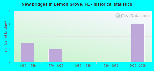
- New bridges - historical statistics
- 31960-1969
- 21970-1979
- 62000-2009


- Bridge Condition - Deck
- 14.3%Very good
- 42.9%Good
- 42.9%Satisfactory

- Bridge Condition - Superstructure
- 14.3%Very good
- 42.9%Good
- 42.9%Satisfactory

- Bridge Condition - Substructure
- 14.3%Very good
- 85.7%Good

- Bridge Condition - Channel
- 36.4%Good
- 45.5%Satisfactory
- 18.2%Fair

- Bridge Condition - Culverts
- 50.0%Good
- 25.0%Satisfactory
- 25.0%Fair
Find on map >> Show street view
Structure Number: 60046, Location: 3.3 MI S OF SR-64 (Lat: 27.529017, Lng: -81.614919), Route carried "on" structure: County highway 671, Year Built: 1974, Status: Posted for load, Structure Length: 4.57m (14.99ft), Average Daily Traffic: 600 (year 2020), Truck Traffic: 23%, Average Future Daily Traffic: 1,041 (year 2042), Design Load: HS 20, Features Intersected: BEE BRANCH
Minimum Vertical Clearance: 30+ m (98+ ft), Kilometerpoint: 2.440, Lanes on structure: 2, Owner: County Highway Agency, Approaching Roadway Width: 6.3m (20.7ft), Material/Design: Concrete continuous, Design/Construction: Slab, Number Of Spans In Main Unit: 5, Length of Maximum Span: 9.6m (31.5ft), Curb-To-Curb Width: 8.8m (28.9ft), Out-to-Out Width: 9.5m (31.2ft)
Condition: Deck: Good, Superstructure: Good, Substructure: Good, Channel: Satisfactory, Operating Rating: 36.0 metric tons, Method Used To Determine Operating Rating: Load Factor (LF), Inventory Rating: 21.6 metric tons, Method Used To Determine Inventory Rating: Load Factor (LF), Structural Evaluation: Somewhat better than minimum adequacy, Deck Geometry: Somewhat better than minimum adequacy, Waterway Adequacy: Equal to present desirable criteria, Approach Roadway Alignment: Equal to present desirable criteria, Bridge Posting: Required (Relationship of Operating Rating to Maximum Legal Load: 10.0 - 19.9% below), Designated Inspection Frequency: Every 24 months, Underwater Inspection Frequency: Every 24 months, Other Special Inspection Frequency: Every 12 months, Inspection Date: Febuary 2021, Underwater Inspection Date: January 2021, Other Special Inspection Date: Febuary 2022, Deck Structure Type: Concrete Cast-file-Place
Find on map >> Show street view
Structure Number: 64079, Location: 4.1 MI S OF SR-64 (Lat: 27.518772, Lng: -81.610750), Route carried "on" structure: County highway 671, Year Built: 1970, Status: Open, Structure Length: 0.94m (3.08ft), Average Daily Traffic: 600 (year 2020), Truck Traffic: 23%, Average Future Daily Traffic: 1,041 (year 2042), Design Load: H 20, Features Intersected: CHARLIES CREEK
Minimum Vertical Clearance: 30+ m (98+ ft), Kilometerpoint: 1.233, Lanes on structure: 2, Owner: County Highway Agency, Approaching Roadway Width: 6.4m (21.0ft), Skew: 2 degrees, Material/Design: Concrete, Design/Construction: Culvert, Number Of Spans In Main Unit: 3, Length of Maximum Span: 2.9m (9.5ft)
Condition: Channel: Fair, Culverts: Fair, Operating Rating: 48.0 metric tons, Method Used To Determine Operating Rating: Load Factor (LF), Inventory Rating: 28.8 metric tons, Method Used To Determine Inventory Rating: Load Factor (LF), Structural Evaluation: Somewhat better than minimum adequacy, Waterway Adequacy: Better than present minimum criteria, Approach Roadway Alignment: Equal to present desirable criteria, Designated Inspection Frequency: Every 24 months, Inspection Date: Febuary 2021
Find on map >> Show street view
Structure Number: 64122, Location: 3.1 MI SOUTH OF SR-64 (Lat: 27.517856, Lng: -81.665997), Route carried "on" structure: County highway , Year Built: 2007, Status: Open, Structure Length: 3.44m (11.29ft), Average Daily Traffic: 370 (year 2022), Truck Traffic: 8%, Average Future Daily Traffic: 642 (year 2042), Design Load: HS 20, Features Intersected: BUCKHORN CREEK, Facility Carried by Structure: KELLY ROBERTS ROAD
Minimum Vertical Clearance: 30+ m (98+ ft), Kilometerpoint: 7.187, Lanes on structure: 2, Owner: County Highway Agency, Approaching Roadway Width: 10.4m (34.1ft), Skew: 1 degrees, Material/Design: Concrete continuous, Design/Construction: Slab, Number Of Spans In Main Unit: 3, Length of Maximum Span: 13.1m (43.0ft), Curb-To-Curb Width: 10.4m (34.1ft), Out-to-Out Width: 11.3m (37.1ft)
Condition: Deck: Very good, Superstructure: Very good, Substructure: Very good, Channel: Satisfactory, Structural Evaluation: Equal to present desirable criteria, Deck Geometry: Better than present minimum criteria, Waterway Adequacy: Better than present minimum criteria, Approach Roadway Alignment: Equal to present desirable criteria, Designated Inspection Frequency: Every 24 months, Underwater Inspection Frequency: Every 24 months, Inspection Date: January 2022, Underwater Inspection Date: December 2021, Deck Structure Type: Concrete Cast-file-Place, Wearing Surface/Protective System: Wearing Surface: Monolithic Concrete
Find on map >> Show street view
Structure Number: 64123, Location: 3.7 MI NORTH OF SR-64 (Lat: 27.630944, Lng: -81.620506), Route carried "on" structure: County highway 671, Year Built: 2002, Status: Open, Structure Length: 0.98m (3.22ft), Average Daily Traffic: 300 (year 2020), Truck Traffic: 13%, Average Future Daily Traffic: 520 (year 2042), Features Intersected: OLD TOWN CREEK, Facility Carried by Structure: OLD TOWN CREEK RD
Minimum Vertical Clearance: 30.18m (99.02ft), Kilometerpoint: 6.116, Lanes on structure: 2, Owner: County Highway Agency, Approaching Roadway Width: 8.7m (28.5ft), Material/Design: Concrete, Design/Construction: Culvert, Number Of Spans In Main Unit: 3, Length of Maximum Span: 3.3m (10.8ft)
Condition: Channel: Satisfactory, Culverts: Good, Operating Rating: 73.9 metric tons, Method Used To Determine Operating Rating: Load Factor (LF), Inventory Rating: 44.4 metric tons, Method Used To Determine Inventory Rating: Load Factor (LF), Structural Evaluation: Better than present minimum criteria, Waterway Adequacy: Better than present minimum criteria, Approach Roadway Alignment: Equal to present desirable criteria, Designated Inspection Frequency: Every 24 months, Underwater Inspection Frequency: Every 23 months, Inspection Date: March 2021, Underwater Inspection Date: March 2021
Find on map >> Show street view
Structure Number: 64124, Location: 0.7MI N OF SR-64 (Lat: 27.586131, Lng: -81.620711), Route carried "on" structure: County highway 671, Year Built: 2002, Status: Open, Structure Length: 0.92m (3.02ft), Average Daily Traffic: 300 (year 2020), Truck Traffic: 13%, Average Future Daily Traffic: 521 (year 2042), Features Intersected: LOST CREEK, Facility Carried by Structure: OLD TOWN CREEK RD
Minimum Vertical Clearance: 30+ m (98+ ft), Kilometerpoint: 1.146, Lanes on structure: 2, Owner: County Highway Agency, Approaching Roadway Width: 7.7m (25.3ft), Material/Design: Concrete, Design/Construction: Culvert, Number Of Spans In Main Unit: 3, Length of Maximum Span: 3.0m (9.8ft)
Condition: Channel: Fair, Culverts: Good, Operating Rating: 79.5 metric tons, Method Used To Determine Operating Rating: Load Factor (LF), Inventory Rating: 47.7 metric tons, Method Used To Determine Inventory Rating: Load Factor (LF), Structural Evaluation: Better than present minimum criteria, Waterway Adequacy: Better than present minimum criteria, Approach Roadway Alignment: Equal to present desirable criteria, Designated Inspection Frequency: Every 24 months, Underwater Inspection Frequency: Every 23 months, Inspection Date: March 2021, Underwater Inspection Date: March 2021
Find on map >> Show street view
Structure Number: 64126, Location: 0.7MI W OF SR671 PARNELL (Lat: 27.503725, Lng: -81.619914), Route carried "on" structure: County highway 636, Year Built: 2004, Status: Open, Structure Length: 3.37m (11.06ft), Average Daily Traffic: 600 (year 2020), Truck Traffic: 11%, Average Future Daily Traffic: 1,041 (year 2042), Design Load: HS 25 or greater, Features Intersected: LITTLE CHARLEY BOWLEGS C, Facility Carried by Structure: STEVE ROBERTS SPEC
Minimum Vertical Clearance: 30+ m (98+ ft), Kilometerpoint: 16.269, Lanes on structure: 2, Owner: County Highway Agency, Approaching Roadway Width: 11.6m (38.1ft), Material/Design: Concrete continuous, Design/Construction: Slab, Number Of Spans In Main Unit: 4, Length of Maximum Span: 9.1m (29.9ft), Curb-To-Curb Width: 11.6m (38.1ft), Out-to-Out Width: 12.4m (40.7ft)
Condition: Deck: Good, Superstructure: Good, Substructure: Good, Channel: Good, Operating Rating: 84.4 metric tons, Method Used To Determine Operating Rating: Load Factor (LF), Inventory Rating: 50.8 metric tons, Method Used To Determine Inventory Rating: Load Factor (LF), Structural Evaluation: Better than present minimum criteria, Deck Geometry: Better than present minimum criteria, Waterway Adequacy: Equal to present desirable criteria, Approach Roadway Alignment: Equal to present desirable criteria, Designated Inspection Frequency: Every 24 months, Underwater Inspection Frequency: Every 24 months, Inspection Date: March 2021, Underwater Inspection Date: Febuary 2021, Deck Structure Type: Concrete Cast-file-Place
Find on map >> Show street view
Structure Number: 64127, Location: 2.9MI W OF PARNELL RD. (Lat: 27.500692, Lng: -81.655125), Route carried "on" structure: County highway 636, Year Built: 2003, Status: Open, Structure Length: 4.94m (16.21ft), Average Daily Traffic: 600 (year 2020), Truck Traffic: 11%, Average Future Daily Traffic: 1,041 (year 2042), Design Load: HS 20+Mod, Features Intersected: CHARLIE CREEK, Facility Carried by Structure: STEVE ROBERTS SPEC
Minimum Vertical Clearance: 30+ m (98+ ft), Kilometerpoint: 12.703, Lanes on structure: 2, Owner: County Highway Agency, Approaching Roadway Width: 8.1m (26.6ft), Material/Design: Concrete continuous, Design/Construction: Slab, Number Of Spans In Main Unit: 4, Length of Maximum Span: 12.3m (40.4ft), Curb-To-Curb Width: 11.6m (38.1ft), Out-to-Out Width: 12.5m (41.0ft)
Condition: Deck: Good, Superstructure: Good, Substructure: Good, Channel: Good, Operating Rating: 69.8 metric tons, Method Used To Determine Operating Rating: Load Factor (LF), Inventory Rating: 41.8 metric tons, Method Used To Determine Inventory Rating: Load Factor (LF), Structural Evaluation: Better than present minimum criteria, Deck Geometry: Better than present minimum criteria, Waterway Adequacy: Equal to present desirable criteria, Approach Roadway Alignment: Equal to present desirable criteria, Designated Inspection Frequency: Every 24 months, Inspection Date: March 2021, Deck Structure Type: Concrete Cast-file-Place
Find on map >> Show street view
Structure Number: 64128, Location: 2.2MI W OF PARNELL RD. (Lat: 27.500611, Lng: -81.643644), Route carried "on" structure: County highway 636, Year Built: 2003, Status: Open, Structure Length: 2.74m (8.99ft), Average Daily Traffic: 600 (year 2019), Truck Traffic: 11%, Average Future Daily Traffic: 1,041 (year 2041), Design Load: HS 25 or greater, Features Intersected: TRIBUTARY TO CHARLIE CRK, Facility Carried by Structure: STEVE ROBERTS SPEC
Minimum Vertical Clearance: 30+ m (98+ ft), Kilometerpoint: 13.845, Lanes on structure: 2, Owner: County Highway Agency, Approaching Roadway Width: 11.6m (38.1ft), Material/Design: Concrete continuous, Design/Construction: Slab, Number Of Spans In Main Unit: 3, Length of Maximum Span: 9.1m (29.9ft), Curb-To-Curb Width: 11.6m (38.1ft), Out-to-Out Width: 12.6m (41.3ft)
Condition: Deck: Satisfactory, Superstructure: Satisfactory, Substructure: Good, Channel: Good, Inventory Rating: 57.2 metric tons, Method Used To Determine Inventory Rating: Load Factor (LF), Structural Evaluation: Equal to present minimum criteria, Deck Geometry: Better than present minimum criteria, Waterway Adequacy: Better than present minimum criteria, Approach Roadway Alignment: Equal to present desirable criteria, Designated Inspection Frequency: Every 24 months, Underwater Inspection Frequency: Every 24 months, Inspection Date: March 2021, Underwater Inspection Date: Febuary 2021, Deck Structure Type: Concrete Cast-file-Place
Find on map >> Show street view
Structure Number: 160164, Location: 8.0 MI E OF US-17 (Lat: 27.646381, Lng: -81.697739), Route carried "on" structure: County highway 664, Year Built: 1965, Status: Open, Structure Length: 0.63m (2.07ft), Average Daily Traffic: 500 (year 2020), Truck Traffic: 12%, Average Future Daily Traffic: 868 (year 2042), Features Intersected: BRIAN'S RUN
Minimum Vertical Clearance: 30+ m (98+ ft), Kilometerpoint: 12.316, Lanes on structure: 2, Owner: County Highway Agency, Approaching Roadway Width: 9.1m (29.9ft), Material/Design: Concrete, Design/Construction: Culvert, Number Of Spans In Main Unit: 2, Length of Maximum Span: 3.2m (10.5ft)
Condition: Channel: Satisfactory, Culverts: Satisfactory, Operating Rating: 73.2 metric tons, Method Used To Determine Operating Rating: Load Factor (LF), Inventory Rating: 43.9 metric tons, Method Used To Determine Inventory Rating: Load Factor (LF), Structural Evaluation: Equal to present minimum criteria, Waterway Adequacy: Better than present minimum criteria, Approach Roadway Alignment: Equal to present desirable criteria, Designated Inspection Frequency: Every 24 months, Underwater Inspection Frequency: Every 24 months, Inspection Date: July 2021, Underwater Inspection Date: June 2021
Find on map >> Show street view
Structure Number: 164309, Location: 10.5MI EAST OF US 17 (Lat: 27.646453, Lng: -81.648906), Route carried "on" structure: County highway , Year Built: 1960, Status: Open, Structure Length: 1.51m (4.95ft), Average Daily Traffic: 500 (year 2020), Truck Traffic: 12%, Average Future Daily Traffic: 868 (year 2042), Design Load: HS 20, Features Intersected: BRANCH OF CHARLIE CREEK, Facility Carried by Structure: COUNTY LINE ROAD
Minimum Vertical Clearance: 30+ m (98+ ft), Kilometerpoint: 17.128, Lanes on structure: 2, Owner: County Highway Agency, Approaching Roadway Width: 6.8m (22.3ft), Material/Design: Prestressed concrete, Design/Construction: Channel Beam, Number Of Spans In Main Unit: 2, Length of Maximum Span: 7.6m (24.9ft), Curb-To-Curb Width: 7.6m (24.9ft), Out-to-Out Width: 8.2m (26.9ft)
Condition: Deck: Satisfactory, Superstructure: Satisfactory, Substructure: Good, Channel: Good, Operating Rating: 48.6 metric tons, Method Used To Determine Operating Rating: Load Factor (LF), Inventory Rating: 26.5 metric tons, Method Used To Determine Inventory Rating: Load Factor (LF), Structural Evaluation: Equal to present minimum criteria, Deck Geometry: Meets minimum limits, Waterway Adequacy: Better than present minimum criteria, Approach Roadway Alignment: Equal to present desirable criteria, Designated Inspection Frequency: Every 24 months, Inspection Date: July 2021, Deck Structure Type: Concrete Cast-file-Place
Find on map >> Show street view
Structure Number: 16431, Location: 6.3 Mi. West of US-27 (Lat: 27.646456, Lng: -81.633178), Route carried "on" structure: County highway , Year Built: 1960, Status: Open, Structure Length: 1.22m (4.00ft), Average Daily Traffic: 500 (year 2020), Truck Traffic: 12%, Average Future Daily Traffic: 868 (year 2042), Design Load: HS 20, Features Intersected: BRANCH OF CHARLIE CREEK, Facility Carried by Structure: COUNTY LINE RD
Minimum Vertical Clearance: 30+ m (98+ ft), Kilometerpoint: 18.681, Lanes on structure: 2, Owner: County Highway Agency, Approaching Roadway Width: 8.1m (26.6ft), Material/Design: Prestressed concrete, Design/Construction: Channel Beam, Number Of Spans In Main Unit: 2, Length of Maximum Span: 6.1m (20.0ft), Curb-To-Curb Width: 8.7m (28.5ft), Out-to-Out Width: 9.4m (30.8ft)
Condition: Deck: Satisfactory, Superstructure: Satisfactory, Substructure: Good, Channel: Satisfactory, Operating Rating: 63.3 metric tons, Method Used To Determine Operating Rating: Load Factor (LF), Inventory Rating: 37.9 metric tons, Method Used To Determine Inventory Rating: Load Factor (LF), Structural Evaluation: Equal to present minimum criteria, Deck Geometry: Somewhat better than minimum adequacy, Waterway Adequacy: Better than present minimum criteria, Approach Roadway Alignment: Equal to present desirable criteria, Designated Inspection Frequency: Every 24 months, Inspection Date: July 2021, Deck Structure Type: Concrete Cast-file-Place