Bridge Statistics for Lehighton, Pennsylvania (PA)
Condition, Traffic, Stress, Structural Evaluation, Project Costs
- National Bridge Inventory (NBI) Statistics
- 12Number of bridges
- 272ft / 82.6mTotal length
- $4,224,000Total costs
- 50,115Total average daily traffic
- 1,816Total average daily truck traffic
- National Bridge Inventory (NBI) Registered Bridges for Lehighton
- No street view available for this location
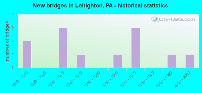
- New bridges - historical statistics
- 21910-1919
- 31930-1939
- 11940-1949
- 11960-1969
- 31970-1979
- 11990-1999
- 12000-2009

- Reconstructed bridges - Historical Statistics
- 21970-1979
- 01980-1989
- 01990-1999
- 02000-2009
- 12010-2019


- Bridge Condition - Deck
- 14.3%Good
- 14.3%Satisfactory
- 57.1%Fair
- 14.3%Poor

- Bridge Condition - Superstructure
- 22.2%Satisfactory
- 55.6%Fair
- 22.2%Poor

- Bridge Condition - Substructure
- 33.3%Satisfactory
- 33.3%Fair
- 33.3%Poor

- Bridge Condition - Channel
- 22.2%Good
- 33.3%Satisfactory
- 33.3%Fair
- 11.1%Poor
Find on map >> Show street view
Structure Number: 8996, Location: THOMAS J.MCCALL MEM.BRIDG (Lat: 40.827194, Lng: -75.704550), Route carried "on" structure: US 209, Year Built: 1938, Year Reconstructed: 2015, Status: Open, Structure Length: 46.91m (153.90ft), Average Daily Traffic: 21,574 (year 2022), Truck Traffic: 5%, Average Future Daily Traffic: 30,025 (year 2032), Design Load: HS 20, Features Intersected: NO/SOUT,RRS.,STS.,CANAL
Minimum Vertical Clearance: 30+ m (98+ ft), Kilometerpoint: 22.864, Lanes on structure: 3, Lanes under structure: 4, Base Highway Network: Yes, Owner: State Highway Agency, Approaching Roadway Width: 11.9m (39.0ft), Skew: 9 degrees, Material/Design: Steel, Design/Construction: Truss - Deck, Number Of Spans In Main Unit: 3, Number Of Approach Spans: 13, Length of Maximum Span: 49.7m (163.1ft), Curb or Sidewalk Widths: Left: 1.6m (5.2ft), Right: 0.2m (0.7ft), Curb-To-Curb Width: 10.4m (34.1ft), Out-to-Out Width: 12.8m (42.0ft)
Condition: Deck: Good, Superstructure: Fair, Substructure: Satisfactory, Channel: Good, Operating Rating: 41.7 metric tons, Method Used To Determine Operating Rating: Load Factor (LF), Inventory Rating: 26.3 metric tons, Method Used To Determine Inventory Rating: Load Factor (LF), Structural Evaluation: Somewhat better than minimum adequacy, Deck Geometry: High priority of replacement, Underclear: Meets minimum limits, Waterway Adequacy: Superior to present desirable criteria, Approach Roadway Alignment: Somewhat better than minimum adequacy, Length Of Structure Improvement: 47.60m (156.17ft), Designated Inspection Frequency: Every 24 months, Critical Feature Inspection Frequency: Every 24 months, Underwater Inspection Frequency: Every 60 months, Inspection Date: June 2021, Critical Feature Inspection Date: June 2021, Underwater Inspection Date: March 2017, Bridge Improvement Cost: $47,000, Roadway Improvement Cost: $137,000, Total Project Cost: $630,000, Deck Structure Type: Concrete Cast-file-Place, Wearing Surface/Protective System: Wearing Surface: Latex Concrete, Deck Protection: Epoxy Coated Reinforcing
Find on map >> Show street view
Structure Number: 9017, Location: BLAKESLEE BLVD. (Lat: 40.822711, Lng: -75.711217), Route carried "on" structure: State highway 443, Year Built: 1945, Status: Open, Structure Length: 4.82m (15.81ft), Average Daily Traffic: 13,135 (year 2021), Truck Traffic: 3%, Average Future Daily Traffic: 19,613 (year 2032), Design Load: HS 20, Features Intersected: MAHONING CREEK
Minimum Vertical Clearance: 30+ m (98+ ft), Kilometerpoint: 10.699, Lanes on structure: 2, Owner: State Highway Agency, Approaching Roadway Width: 13.1m (43.0ft), Skew: 2 degrees, Material/Design: Steel continuous, Design/Construction: Stringer/Multi-beam, Number Of Spans In Main Unit: 3, Length of Maximum Span: 15.8m (51.8ft), Curb or Sidewalk Widths: Left: 1.5m (4.9ft), Right: 0.0m, Curb-To-Curb Width: 11.7m (38.4ft), Out-to-Out Width: 13.7m (44.9ft)
Condition: Deck: Fair, Superstructure: Poor, Substructure: Poor, Channel: Fair, Operating Rating: 36.3 metric tons, Method Used To Determine Operating Rating: Load Factor (LF), Inventory Rating: 21.8 metric tons, Method Used To Determine Inventory Rating: Load Factor (LF), Structural Evaluation: Meets minimum limits, Deck Geometry: Somewhat better than minimum adequacy, Waterway Adequacy: Superior to present desirable criteria, Approach Roadway Alignment: Equal to present desirable criteria, Length Of Structure Improvement: 5.70m (18.70ft), Designated Inspection Frequency: Every 24 months, Inspection Date: April 2020, Deck Structure Type: Concrete Cast-file-Place, Wearing Surface/Protective System: Wearing Surface: Bituminous
Find on map >> Show street view
Structure Number: 9038, Location: NINTH STREET,LEHIGHTON (Lat: 40.822094, Lng: -75.720489), Route carried "on" structure: State highway 902, Year Built: 1964, Status: Open, Structure Length: 4.51m (14.80ft), Average Daily Traffic: 5,728 (year 2021), Truck Traffic: 3%, Average Future Daily Traffic: 8,469 (year 2032), Design Load: HS 20, Features Intersected: MAHONING CREEK
Minimum Vertical Clearance: 30+ m (98+ ft), Kilometerpoint: 17.675, Lanes on structure: 2, Owner: State Highway Agency, Approaching Roadway Width: 12.2m (40.0ft), Skew: 3 degrees, Material/Design: Steel, Design/Construction: Stringer/Multi-beam, Number Of Spans In Main Unit: 2, Length of Maximum Span: 21.9m (71.9ft), Curb or Sidewalk Widths: Left: 0.5m (1.6ft), Right: 1.5m (4.9ft), Curb-To-Curb Width: 12.2m (40.0ft), Out-to-Out Width: 14.9m (48.9ft)
Condition: Deck: Fair, Superstructure: Fair, Substructure: Poor, Channel: Fair, Operating Rating: 89.8 metric tons, Method Used To Determine Operating Rating: Load Factor (LF), Inventory Rating: 53.5 metric tons, Method Used To Determine Inventory Rating: Load Factor (LF), Structural Evaluation: Meets minimum limits, Deck Geometry: Somewhat better than minimum adequacy, Waterway Adequacy: Better than present minimum criteria, Approach Roadway Alignment: Equal to present desirable criteria, Length Of Structure Improvement: 5.50m (18.04ft), Designated Inspection Frequency: Every 24 months, Other Special Inspection Frequency: Every 6 months, Inspection Date: June 2021, Other Special Inspection Date: June 2021, Bridge Improvement Cost: $111,000, Roadway Improvement Cost: $328,000, Total Project Cost: $1,503,000, Deck Structure Type: Concrete Cast-file-Place, Wearing Surface/Protective System: Wearing Surface: Monolithic Concrete
Find on map >> Show street view
Structure Number: 9077, Location: LEHIGHTON-WEISPORT BOROS (Lat: 40.828844, Lng: -75.704933), Route carried "on" structure: State highway , Year Built: 1971, Year Reconstructed: 1979, Status: Open, Structure Length: 15.91m (52.20ft), Average Daily Traffic: 7,828 (year 2020), Truck Traffic: 2%, Average Future Daily Traffic: 7,648 (year 2032), Design Load: HS 20, Features Intersected: LEHIGH RIVER & LEHIGH DR, Facility Carried by Structure: SR 2010 (LR 164)
Minimum Vertical Clearance: 30+ m (98+ ft), Kilometerpoint: 0.000, Lanes on structure: 2, Lanes under structure: 2, Owner: State Highway Agency, Approaching Roadway Width: 13.4m (44.0ft), Material/Design: Prestressed concrete, Design/Construction: Box Beam or Girders - Single/Spread, Number Of Spans In Main Unit: 6, Number Of Approach Spans: 1, Length of Maximum Span: 22.9m (75.1ft), Curb or Sidewalk Widths: Left: 1.5m (4.9ft), Right: 1.5m (4.9ft), Curb-To-Curb Width: 13.4m (44.0ft), Out-to-Out Width: 17.2m (56.4ft)
Condition: Deck: Satisfactory, Superstructure: Satisfactory, Substructure: Fair, Channel: Good, Inventory Rating: 29.0 metric tons, Method Used To Determine Inventory Rating: Load Factor (LF), Structural Evaluation: Somewhat better than minimum adequacy, Deck Geometry: Equal to present minimum criteria, Underclear: Superior to present desirable criteria, Waterway Adequacy: Superior to present desirable criteria, Approach Roadway Alignment: Equal to present desirable criteria, Length Of Structure Improvement: 16.80m (55.12ft), Designated Inspection Frequency: Every 24 months, Underwater Inspection Frequency: Every 60 months, Inspection Date: September 2020, Underwater Inspection Date: November 2018, Bridge Improvement Cost: $116,000, Roadway Improvement Cost: $341,000, Total Project Cost: $1,564,000, Deck Structure Type: Concrete Cast-file-Place, Wearing Surface/Protective System: Wearing Surface: Bituminous
Find on map >> Show street view
Structure Number: 9115, Location: S. OF SR 895 NR ASHFIELD (Lat: 40.782247, Lng: -75.710972), Route carried "on" structure: City street , Year Built: 1992, Status: Open, Structure Length: 1.58m (5.18ft), Average Daily Traffic: 300 (year 1979), Truck Traffic: 1%, Average Future Daily Traffic: 450 (year 1999), Design Load: HS 25 or greater, Features Intersected: LIZARD CREEK, Facility Carried by Structure: BLUE MOUNTAIN RD
Minimum Vertical Clearance: 30+ m (98+ ft), Kilometerpoint: 0.000, Lanes on structure: 2, Owner: County Highway Agency, Approaching Roadway Width: 6.1m (20.0ft), Material/Design: Prestressed concrete, Design/Construction: Box Beam or Girders - Multiple, Number Of Spans In Main Unit: 1, Length of Maximum Span: 15.2m (49.9ft), Curb or Sidewalk Widths: Left: 0.2m (0.7ft), Right: 0.2m (0.7ft), Curb-To-Curb Width: 7.5m (24.6ft), Out-to-Out Width: 8.6m (28.2ft)
Condition: Deck: Poor, Superstructure: Poor, Substructure: Satisfactory, Channel: Fair, Operating Rating: 45.4 metric tons, Method Used To Determine Operating Rating: Load Factor (LF), Inventory Rating: 21.8 metric tons, Method Used To Determine Inventory Rating: Load Factor (LF), Structural Evaluation: Meets minimum limits, Deck Geometry: Somewhat better than minimum adequacy, Waterway Adequacy: Equal to present desirable criteria, Approach Roadway Alignment: Equal to present desirable criteria, Length Of Structure Improvement: 1.50m (4.92ft), Designated Inspection Frequency: Every 24 months, Inspection Date: November 2020, Bridge Improvement Cost: $20,000, Roadway Improvement Cost: $56,000, Total Project Cost: $270,000, Deck Structure Type: Other, Wearing Surface/Protective System: Wearing Surface: Bituminous
Find on map >> Show street view
Structure Number: 9123, Location: 500'N.OF SR 443 (Lat: 40.813475, Lng: -75.744711), Route carried "on" structure: City street , Year Built: 1910, Year Reconstructed: 1978, Status: Open, Structure Length: 2.04m (6.69ft), Average Daily Traffic: 250 (year 1980), Truck Traffic: 1%, Average Future Daily Traffic: 350 (year 2000), Design Load: HS 20, Features Intersected: MAHONING CREEK, Facility Carried by Structure: FREDERICKS GRVE RD
Minimum Vertical Clearance: 30+ m (98+ ft), Kilometerpoint: 0.000, Lanes on structure: 2, Owner: County Highway Agency, Approaching Roadway Width: 8.5m (27.9ft), Skew: 4 degrees, Material/Design: Concrete, Design/Construction: Arch - Deck, Number Of Spans In Main Unit: 1, Length of Maximum Span: 20.4m (66.9ft), Curb-To-Curb Width: 8.8m (28.9ft), Out-to-Out Width: 9.6m (31.5ft)
Condition: Deck: Fair, Superstructure: Fair, Substructure: Fair, Channel: Satisfactory, Operating Rating: 49.0 metric tons, Method Used To Determine Operating Rating: Field evaluation and documented engineering judgment, Inventory Rating: 32.7 metric tons, Method Used To Determine Inventory Rating: Field evaluation and documented engineering judgment, Structural Evaluation: Somewhat better than minimum adequacy, Deck Geometry: Equal to present minimum criteria, Waterway Adequacy: Equal to present desirable criteria, Approach Roadway Alignment: Somewhat better than minimum adequacy, Length Of Structure Improvement: 2.70m (8.86ft), Designated Inspection Frequency: Every 24 months, Inspection Date: November 2021, Deck Structure Type: Concrete Cast-file-Place, Wearing Surface/Protective System: Wearing Surface: Monolithic Concrete
Find on map >> Show street view
Structure Number: 9136, Location: 1 MILE NORTH RTE 443 (Lat: 40.822822, Lng: -75.727075), Route carried "on" structure: City street , Year Built: 1910, Status: Open, Structure Length: 1.37m (4.49ft), Average Daily Traffic: 500 (year 1980), Truck Traffic: 1%, Average Future Daily Traffic: 1,750 (year 2030), Features Intersected: MAHONING CREEK, Facility Carried by Structure: ASHTOWN DR.
Minimum Vertical Clearance: 30+ m (98+ ft), Kilometerpoint: 0.000, Lanes on structure: 2, Owner: City or Municipal Highway Agency, Approaching Roadway Width: 5.8m (19.0ft), Material/Design: Masonry, Design/Construction: Arch - Deck, Number Of Spans In Main Unit: 2, Length of Maximum Span: 6.1m (20.0ft), Curb-To-Curb Width: 6.1m (20.0ft), Out-to-Out Width: 7.6m (24.9ft)
Condition: Superstructure: Fair, Substructure: Satisfactory, Channel: Satisfactory, Operating Rating: 49.0 metric tons, Method Used To Determine Operating Rating: Field evaluation and documented engineering judgment, Inventory Rating: 32.7 metric tons, Method Used To Determine Inventory Rating: Field evaluation and documented engineering judgment, Structural Evaluation: Somewhat better than minimum adequacy, Deck Geometry: High priority of corrective action, Waterway Adequacy: Better than present minimum criteria, Approach Roadway Alignment: Equal to present desirable criteria, Length Of Structure Improvement: 2.40m (7.87ft), Designated Inspection Frequency: Every 24 months, Inspection Date: March 2020, Bridge Improvement Cost: $15,000, Roadway Improvement Cost: $86,000, Total Project Cost: $198,000
Find on map >> Show street view
Structure Number: 9137, Location: JUST NORTH OF RTE. 443 (Lat: 40.823928, Lng: -75.715722), Route carried "on" structure: City street , Year Built: 1971, Status: Open, Structure Length: 2.62m (8.60ft), Average Daily Traffic: 500 (year 1980), Truck Traffic: 1%, Average Future Daily Traffic: 700 (year 2000), Design Load: HS 20, Features Intersected: MAHONING CREEK, Facility Carried by Structure: EAST PENN STREET
Minimum Vertical Clearance: 30+ m (98+ ft), Kilometerpoint: 0.000, Lanes on structure: 2, Owner: County Highway Agency, Approaching Roadway Width: 8.5m (27.9ft), Skew: 4 degrees, Material/Design: Prestressed concrete, Design/Construction: Box Beam or Girders - Multiple, Number Of Spans In Main Unit: 2, Length of Maximum Span: 12.5m (41.0ft), Curb or Sidewalk Widths: Left: 0.3m (1.0ft), Right: 1.5m (4.9ft), Curb-To-Curb Width: 8.4m (27.6ft), Out-to-Out Width: 11.0m (36.1ft)
Condition: Deck: Fair, Superstructure: Fair, Substructure: Poor, Channel: Satisfactory, Operating Rating: 69.9 metric tons, Method Used To Determine Operating Rating: Load Factor (LF), Inventory Rating: 27.2 metric tons, Method Used To Determine Inventory Rating: Load Factor (LF), Structural Evaluation: Meets minimum limits, Deck Geometry: Somewhat better than minimum adequacy, Waterway Adequacy: Equal to present desirable criteria, Approach Roadway Alignment: Better than present minimum criteria, Length Of Structure Improvement: 2.60m (8.53ft), Designated Inspection Frequency: Every 24 months, Inspection Date: November 2020, Bridge Improvement Cost: $4,000, Roadway Improvement Cost: $9,000, Total Project Cost: $59,000, Deck Structure Type: Concrete Cast-file-Place, Wearing Surface/Protective System: Wearing Surface: Bituminous
Find on map >> Show street view
Structure Number: 44021, Location: SOUTH OF 209/443 @ RIVER (Lat: 40.825019, Lng: -75.700750), Route carried "on" structure: City street , Year Built: 2006, Status: Open, Structure Length: 2.87m (9.42ft), Average Daily Traffic: 99 (year 2009), Average Future Daily Traffic: 5,595 (year 2030), Features Intersected: MAHONING CREEK, Facility Carried by Structure: LEHIGH DRIVE
Minimum Vertical Clearance: 30+ m (98+ ft), Kilometerpoint: 0.000, Lanes on structure: 2, Owner: City or Municipal Highway Agency, Approaching Roadway Width: 6.4m (21.0ft), Material/Design: Masonry, Design/Construction: Arch - Deck, Number Of Spans In Main Unit: 4, Length of Maximum Span: 6.1m (20.0ft), Curb or Sidewalk Widths: Left: 0.2m (0.7ft), Right: 0.2m (0.7ft), Curb-To-Curb Width: 7.8m (25.6ft), Out-to-Out Width: 8.8m (28.9ft)
Condition: Superstructure: Satisfactory, Substructure: Fair, Channel: Poor, Operating Rating: 49.0 metric tons, Method Used To Determine Operating Rating: Field evaluation and documented engineering judgment, Inventory Rating: 32.7 metric tons, Method Used To Determine Inventory Rating: Field evaluation and documented engineering judgment, Structural Evaluation: Somewhat better than minimum adequacy, Deck Geometry: Equal to present minimum criteria, Waterway Adequacy: Better than present minimum criteria, Approach Roadway Alignment: Equal to present desirable criteria, Designated Inspection Frequency: Every 24 months, Inspection Date: March 2021
Find on map >> Show street view
Structure Number: 8996, Location: THOMAS J.MCCALL MEM.BRIDG (Lat: 40.827194, Lng: -75.704550), Route carried "under" structure: City street LOCL, Year Built: 1938, Structure Length: 0. m, Average Daily Traffic: 100 (year 1996), Truck Traffic: 1%, Features Intersected: NO/SOUT,RRS.,STS.,CANAL, Facility Carried by Structure: US 209 (LR 163)
Minimum Vertical Clearance: 6.22m (20.41ft), Kilometerpoint: 0.000, Lanes on structure: 3, Lanes under structure: 2, Material/Design: Steel, Design/Construction: Truss - Deck, Length of Maximum Span: 49.7m (163.1ft)
Find on map >> Show street view
Structure Number: 8996, Location: THOMAS J.MCCALL MEM.BRIDG (Lat: 40.827194, Lng: -75.704550), Route carried "under" structure: ServiceCity street , Year Built: 1938, Structure Length: 0. m, Average Daily Traffic: 100 (year 2005), Truck Traffic: 1%, Features Intersected: NO/SOUT,RRS.,STS.,CANAL, Facility Carried by Structure: US 209 (LR 163)
Minimum Vertical Clearance: 6.92m (22.70ft), Kilometerpoint: 0.000, Lanes on structure: 3, Lanes under structure: 2, Material/Design: Steel, Design/Construction: Truss - Deck, Length of Maximum Span: 49.7m (163.1ft)
Find on map >> Show street view
Structure Number: 9077, Location: LEHIGHTON-WEISPORT BOROS (Lat: 40.828844, Lng: -75.704933), Route carried "under" structure: ServiceCity street , Year Built: 1971, Structure Length: 0. m, Average Daily Traffic: 1 (year 2004), Features Intersected: LEHIGH RIVER & LEHIGH DR, Facility Carried by Structure: SR 2010 (LR 164)
Minimum Vertical Clearance: 6.18m (20.28ft), Kilometerpoint: 0.000, Lanes on structure: 2, Lanes under structure: 2, Material/Design: Prestressed concrete, Design/Construction: Box Beam or Girders - Single/Spread, Length of Maximum Span: 22.9m (75.1ft)