Bridge Statistics for Lee, Florida (FL)
Condition, Traffic, Stress, Structural Evaluation, Project Costs
- National Bridge Inventory (NBI) Statistics
- 10Number of bridges
- 115ft / 35.4mTotal length
- 78,608Total average daily traffic
- 15,174Total average daily truck traffic
- National Bridge Inventory (NBI) Registered Bridges for Lee
- No street view available for this location
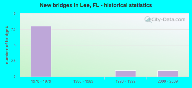
- New bridges - historical statistics
- 81970-1979
- 11990-1999
- 12000-2009


- Bridge Condition - Superstructure
- 40.0%Good
- 60.0%Satisfactory

- Bridge Condition - Substructure
- 20.0%Very good
- 80.0%Good

- Bridge Condition - Channel
- 50.0%Very good
- 50.0%Good
Find on map >> Show street view
Structure Number: 124121, Location: 1MI WEST OF I-75 (Lat: 26.431256, Lng: -81.793350), Route carried "on" structure: County highway 850, Year Built: 1999, Status: Open, Structure Length: 0.99m (3.25ft), Average Daily Traffic: 19,000 (year 2021), Truck Traffic: 5%, Average Future Daily Traffic: 23,750 (year 2041), Design Load: HS 20, Features Intersected: ESTERO RIVER, Facility Carried by Structure: CORKSCREW ROAD
Minimum Vertical Clearance: 30+ m (98+ ft), Kilometerpoint: 1.730, Lanes on structure: 5, Owner: County Highway Agency, Approaching Roadway Width: 21.5m (70.5ft), Skew: 11 degrees, Material/Design: Concrete, Design/Construction: Culvert, Number Of Spans In Main Unit: 3, Length of Maximum Span: 3.3m (10.8ft)
Condition: Channel: Good, Culverts: Satisfactory, Structural Evaluation: Equal to present minimum criteria, Waterway Adequacy: Equal to present desirable criteria, Approach Roadway Alignment: Equal to present desirable criteria, Designated Inspection Frequency: Every 24 months, Inspection Date: March 2021
Find on map >> Show street view
Structure Number: 350033, Location: I-10 WB OVER CR-255 (Lat: 30.379917, Lng: -83.297833), Route carried "on" structure: Interstate 10, Year Built: 1971, Status: Open, Structure Length: 7.19m (23.59ft), Average Daily Traffic: 11,000 (year 2020), Truck Traffic: 28%, Average Future Daily Traffic: 19,085 (year 2042), Design Load: HS 20, Features Intersected: CR-255
Minimum Vertical Clearance: 30+ m (98+ ft), Kilometerpoint: 42.628, Lanes on structure: 2, Lanes under structure: 3, Base Highway Network: Yes, Owner: State Highway Agency, Approaching Roadway Width: 11.9m (39.0ft), Skew: 3 degrees, Material/Design: Prestressed concrete, Design/Construction: Stringer/Multi-beam, Number Of Spans In Main Unit: 4, Length of Maximum Span: 23.7m (77.8ft), Curb-To-Curb Width: 12.0m (39.4ft), Out-to-Out Width: 12.9m (42.3ft)
Condition: Deck: Good, Superstructure: Satisfactory, Substructure: Good, Operating Rating: 34.5 metric tons, Method Used To Determine Operating Rating: Load and Resistance Factor (LRFR), Inventory Rating: 31.1 metric tons, Method Used To Determine Inventory Rating: Load and Resistance Factor (LRFR), Structural Evaluation: Equal to present minimum criteria, Deck Geometry: Equal to present minimum criteria, Underclear: Equal to present minimum criteria, Approach Roadway Alignment: Equal to present desirable criteria, Designated Inspection Frequency: Every 24 months, Inspection Date: July 2020, Deck Structure Type: Concrete Cast-file-Place
Find on map >> Show street view
Structure Number: 350045, Location: I-10 WB OVER SR-53 (Lat: 30.395758, Lng: -83.356267), Route carried "on" structure: Interstate 10, Year Built: 1972, Status: Open, Structure Length: 8.50m (27.89ft), Average Daily Traffic: 12,054 (year 2020), Truck Traffic: 27%, Average Future Daily Traffic: 20,913 (year 2042), Design Load: HS 20+Mod, Features Intersected: SR-53
Minimum Vertical Clearance: 30+ m (98+ ft), Kilometerpoint: 36.725, Lanes on structure: 2, Lanes under structure: 2, Base Highway Network: Yes, Owner: State Highway Agency, Approaching Roadway Width: 11.5m (37.7ft), Skew: 4 degrees, Material/Design: Prestressed concrete, Design/Construction: Stringer/Multi-beam, Number Of Spans In Main Unit: 4, Length of Maximum Span: 27.1m (88.9ft), Curb-To-Curb Width: 12.0m (39.4ft), Out-to-Out Width: 12.8m (42.0ft)
Condition: Deck: Good, Superstructure: Satisfactory, Substructure: Good, Operating Rating: 33.9 metric tons, Method Used To Determine Operating Rating: Load and Resistance Factor (LRFR), Inventory Rating: 21.2 metric tons, Method Used To Determine Inventory Rating: Load and Resistance Factor (LRFR), Structural Evaluation: Somewhat better than minimum adequacy, Deck Geometry: Equal to present minimum criteria, Underclear: Equal to present minimum criteria, Approach Roadway Alignment: Equal to present desirable criteria, Designated Inspection Frequency: Every 24 months, Inspection Date: September 2020, Deck Structure Type: Concrete Cast-file-Place
Find on map >> Show street view
Structure Number: 35005, Location: I-10 EB OVER CR-255 (Lat: 30.379622, Lng: -83.297647), Route carried "on" structure: Interstate 10, Year Built: 1971, Status: Open, Structure Length: 7.19m (23.59ft), Average Daily Traffic: 11,000 (year 2020), Truck Traffic: 28%, Average Future Daily Traffic: 19,085 (year 2042), Design Load: HS 20+Mod, Features Intersected: CR-255
Minimum Vertical Clearance: 30+ m (98+ ft), Kilometerpoint: 42.628, Lanes on structure: 2, Lanes under structure: 3, Base Highway Network: Yes, Owner: State Highway Agency, Approaching Roadway Width: 11.9m (39.0ft), Skew: 3 degrees, Material/Design: Prestressed concrete, Design/Construction: Stringer/Multi-beam, Number Of Spans In Main Unit: 4, Length of Maximum Span: 23.7m (77.8ft), Curb-To-Curb Width: 12.0m (39.4ft), Out-to-Out Width: 12.9m (42.3ft)
Condition: Deck: Good, Superstructure: Good, Substructure: Very good, Operating Rating: 49.9 metric tons, Method Used To Determine Operating Rating: Load Factor (LF), Inventory Rating: 42.6 metric tons, Method Used To Determine Inventory Rating: Load Factor (LF), Structural Evaluation: Better than present minimum criteria, Deck Geometry: Equal to present minimum criteria, Underclear: Equal to present minimum criteria, Approach Roadway Alignment: Equal to present desirable criteria, Designated Inspection Frequency: Every 24 months, Inspection Date: July 2020, Deck Structure Type: Concrete Cast-file-Place
Find on map >> Show street view
Structure Number: 350058, Location: I-10 EB OVER SR-53 (Lat: 30.395472, Lng: -83.356028), Route carried "on" structure: Interstate 10, Year Built: 1972, Status: Open, Structure Length: 8.50m (27.89ft), Average Daily Traffic: 12,054 (year 2020), Truck Traffic: 27%, Average Future Daily Traffic: 20,913 (year 2042), Design Load: HS 20+Mod, Features Intersected: SR-53
Minimum Vertical Clearance: 30+ m (98+ ft), Kilometerpoint: 36.746, Lanes on structure: 2, Lanes under structure: 2, Base Highway Network: Yes, Owner: State Highway Agency, Approaching Roadway Width: 11.7m (38.4ft), Skew: 4 degrees, Material/Design: Prestressed concrete, Design/Construction: Stringer/Multi-beam, Number Of Spans In Main Unit: 4, Length of Maximum Span: 27.1m (88.9ft), Curb-To-Curb Width: 12.0m (39.4ft), Out-to-Out Width: 12.8m (42.0ft)
Condition: Deck: Good, Superstructure: Satisfactory, Substructure: Good, Operating Rating: 39.2 metric tons, Method Used To Determine Operating Rating: Load and Resistance Factor (LRFR), Inventory Rating: 25.5 metric tons, Method Used To Determine Inventory Rating: Load and Resistance Factor (LRFR), Structural Evaluation: Equal to present minimum criteria, Deck Geometry: Equal to present minimum criteria, Underclear: Meets minimum limits, Approach Roadway Alignment: Equal to present desirable criteria, Designated Inspection Frequency: Every 24 months, Inspection Date: September 2020, Deck Structure Type: Concrete Cast-file-Place
Find on map >> Show street view
Structure Number: 354043, Location: 1.2 MI SOUTH OF I-10 (Lat: 30.378333, Lng: -83.345833), Route carried "on" structure: County highway 53, Year Built: 2007, Status: Open, Structure Length: 3.06m (10.04ft), Average Daily Traffic: 1,900 (year 2021), Truck Traffic: 8%, Average Future Daily Traffic: 3,297 (year 2042), Design Load: HL 93, Features Intersected: NORTON CREEK
Minimum Vertical Clearance: 30+ m (98+ ft), Kilometerpoint: 15.049, Lanes on structure: 2, Owner: County Highway Agency, Approaching Roadway Width: 7.9m (25.9ft), Material/Design: Concrete continuous, Design/Construction: Slab, Number Of Spans In Main Unit: 3, Length of Maximum Span: 10.2m (33.5ft), Curb-To-Curb Width: 16.9m (55.4ft), Out-to-Out Width: 17.8m (58.4ft)
Condition: Deck: Good, Superstructure: Good, Substructure: Good, Channel: Very good, Operating Rating: 45.5 metric tons, Method Used To Determine Operating Rating: Load and Resistance Factor (LRFR), Inventory Rating: 35.2 metric tons, Method Used To Determine Inventory Rating: Load and Resistance Factor (LRFR), Structural Evaluation: Better than present minimum criteria, Deck Geometry: Superior to present desirable criteria, Waterway Adequacy: Equal to present desirable criteria, Approach Roadway Alignment: Equal to present desirable criteria, Designated Inspection Frequency: Every 24 months, Inspection Date: July 2021, Deck Structure Type: Concrete Cast-file-Place
Find on map >> Show street view
Structure Number: 350033, Location: I-10 WB OVER CR-255 (Lat: 30.379917, Lng: -83.297833), Route carried "under" structure: County highway 255, Year Built: 1971, Structure Length: 0. m, Average Daily Traffic: 2,200 (year 2020), Truck Traffic: 9%, Features Intersected: CR-255, Facility Carried by Structure: I-10 WB (SR-8)
Minimum Vertical Clearance: 4.63m (15.19ft), Kilometerpoint: 13.010, Lanes on structure: 2, Lanes under structure: 3, Material/Design: Prestressed concrete, Design/Construction: Stringer/Multi-beam, Length of Maximum Span: 23.7m (77.8ft)
Find on map >> Show street view
Structure Number: 350045, Location: I-10 WB OVER SR-53 (Lat: 30.395758, Lng: -83.356267), Route carried "under" structure: State highway 53, Year Built: 1972, Structure Length: 0. m, Average Daily Traffic: 3,600 (year 2020), Truck Traffic: 14%, Features Intersected: SR-53, Facility Carried by Structure: I-10 WB (SR-8)
Minimum Vertical Clearance: 4.51m (14.80ft), Kilometerpoint: 0.526, Lanes on structure: 2, Lanes under structure: 2, Material/Design: Prestressed concrete, Design/Construction: Stringer/Multi-beam, Length of Maximum Span: 27.1m (88.9ft)
Find on map >> Show street view
Structure Number: 35005, Location: I-10 EB OVER CR-255 (Lat: 30.379622, Lng: -83.297647), Route carried "under" structure: County highway 255, Year Built: 1971, Structure Length: 0. m, Average Daily Traffic: 2,200 (year 2020), Truck Traffic: 9%, Features Intersected: CR-255, Facility Carried by Structure: I-10 EB (SR-8)
Minimum Vertical Clearance: 4.63m (15.19ft), Kilometerpoint: 12.978, Lanes on structure: 2, Lanes under structure: 3, Material/Design: Prestressed concrete, Design/Construction: Stringer/Multi-beam, Length of Maximum Span: 23.7m (77.8ft)
Find on map >> Show street view
Structure Number: 350058, Location: I-10 EB OVER SR-53 (Lat: 30.395472, Lng: -83.356028), Route carried "under" structure: State highway 53, Year Built: 1972, Structure Length: 0. m, Average Daily Traffic: 3,600 (year 2020), Truck Traffic: 14%, Features Intersected: SR-53, Facility Carried by Structure: I-10 EB (SR-8)
Minimum Vertical Clearance: 4.42m (14.50ft), Kilometerpoint: 0.486, Lanes on structure: 2, Lanes under structure: 2, Material/Design: Prestressed concrete, Design/Construction: Stringer/Multi-beam, Length of Maximum Span: 27.1m (88.9ft)