Bridge Statistics for Leary, Texas (TX)
Condition, Traffic, Stress, Structural Evaluation, Project Costs
- National Bridge Inventory (NBI) Statistics
- 17Number of bridges
- 125ft / 38.0mTotal length
- 215,285Total average daily traffic
- 80,167Total average daily truck traffic
- National Bridge Inventory (NBI) Registered Bridges for Leary
- No street view available for this location
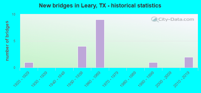
- New bridges - historical statistics
- 11920-1929
- 41950-1959
- 91960-1969
- 11990-1999
- 22010-2019

- Reconstructed bridges - Historical Statistics
- 11930-1939
- 01940-1949
- 01950-1959
- 01960-1969
- 01970-1979
- 21980-1989


- Bridge Condition - Deck
- 75.0%Good
- 25.0%Satisfactory

- Bridge Condition - Substructure
- 50.0%Good
- 50.0%Satisfactory

- Bridge Condition - Channel
- 54.5%Good
- 45.5%Satisfactory

- Bridge Condition - Culverts
- 30.0%Good
- 70.0%Satisfactory
Find on map >> Show street view
Structure Number: 190190004606014, Location: 0.40 MI E OF FM 2253 (Lat: 33.457167, Lng: -94.196283), Route carried "on" structure: US 82, Year Built: 1924, Year Reconstructed: 1942, Status: Open, Structure Length: 0.64m (2.10ft), Average Daily Traffic: 4,152 (year 2020), Truck Traffic: 16%, Average Future Daily Traffic: 6,900 (year 2033), Features Intersected: LEARY CREEK
Minimum Vertical Clearance: 30+ m (98+ ft), Kilometerpoint: 7.541, Lanes on structure: 2, Owner: State Highway Agency, Approaching Roadway Width: 7.3m (24.0ft), Material/Design: Concrete, Design/Construction: Culvert, Number Of Spans In Main Unit: 2, Length of Maximum Span: 3.0m (9.8ft), Curb-To-Curb Width: 10.3m (33.8ft), Out-to-Out Width: 11.4m (37.4ft)
Condition: Channel: Satisfactory, Culverts: Satisfactory, Operating Rating: 32.7 metric tons, Method Used To Determine Operating Rating: Field evaluation and documented engineering judgment, Inventory Rating: 24.5 metric tons, Method Used To Determine Inventory Rating: Field evaluation and documented engineering judgment, Structural Evaluation: Equal to present minimum criteria, Deck Geometry: Meets minimum limits, Waterway Adequacy: Equal to present minimum criteria, Approach Roadway Alignment: Equal to present desirable criteria, Designated Inspection Frequency: Every 24 months, Inspection Date: August 2020, Deck Structure Type: Concrete Cast-file-Place, Wearing Surface/Protective System: Wearing Surface: Bituminous
Find on map >> Show street view
Structure Number: 190190061007078, Location: 0.20 MI W OF SPUR 74 (Lat: 33.468900, Lng: -94.239364), Route carried "on" structure: Interstate 30, Year Built: 1965, Year Reconstructed: 1986, Status: Open, Structure Length: 1.34m (4.40ft), Average Daily Traffic: 34,456 (year 2020), Truck Traffic: 43%, Average Future Daily Traffic: 45,310 (year 2033), Design Load: H 20, Features Intersected: WEST JONES CREEK
Minimum Vertical Clearance: 30+ m (98+ ft), Kilometerpoint: 49.729, Lanes on structure: 8, Owner: State Highway Agency, Approaching Roadway Width: 45.1m (148.0ft), Skew: 9 degrees, Material/Design: Concrete, Design/Construction: Culvert, Number Of Spans In Main Unit: 5, Length of Maximum Span: 2.4m (7.9ft)
Condition: Channel: Good, Culverts: Satisfactory, Operating Rating: 39.9 metric tons, Method Used To Determine Operating Rating: Load Factor (LF), Inventory Rating: 23.6 metric tons, Method Used To Determine Inventory Rating: Load Factor (LF), Structural Evaluation: Somewhat better than minimum adequacy, Waterway Adequacy: Equal to present minimum criteria, Approach Roadway Alignment: Equal to present desirable criteria, Designated Inspection Frequency: Every 24 months, Inspection Date: August 2020
Find on map >> Show street view
Structure Number: 190190061007081, Location: 0.10 MI W OF FM 1398 (Lat: 33.466817, Lng: -94.220344), Route carried "on" structure: Interstate 30, Year Built: 1965, Status: Open, Structure Length: 1.62m (5.31ft), Average Daily Traffic: 34,456 (year 2020), Truck Traffic: 43%, Average Future Daily Traffic: 45,310 (year 2033), Design Load: HS 20, Features Intersected: E JONES CREEK
Minimum Vertical Clearance: 30+ m (98+ ft), Kilometerpoint: 51.510, Lanes on structure: 4, Owner: State Highway Agency, Approaching Roadway Width: 23.2m (76.1ft), Skew: 20 degrees, Material/Design: Concrete, Design/Construction: Culvert, Number Of Spans In Main Unit: 5, Length of Maximum Span: 3.0m (9.8ft)
Condition: Channel: Good, Culverts: Satisfactory, Operating Rating: 39.9 metric tons, Method Used To Determine Operating Rating: Load Factor (LF), Inventory Rating: 23.6 metric tons, Method Used To Determine Inventory Rating: Load Factor (LF), Structural Evaluation: Somewhat better than minimum adequacy, Waterway Adequacy: Equal to present minimum criteria, Approach Roadway Alignment: Equal to present desirable criteria, Designated Inspection Frequency: Every 24 months, Inspection Date: August 2020
Find on map >> Show street view
Structure Number: 190190061007082, Location: 0.90 MI W OF FM 2253 (Lat: 33.466628, Lng: -94.218453), Route carried "on" structure: State highway 1398, Year Built: 1965, Status: Open, Structure Length: 7.41m (24.31ft), Average Daily Traffic: 800 (year 2013), Truck Traffic: 17%, Average Future Daily Traffic: 1,120 (year 2033), Design Load: H 20, Features Intersected: IH 30
Minimum Vertical Clearance: 30+ m (98+ ft), Kilometerpoint: 9.448, Lanes on structure: 2, Lanes under structure: 4, Owner: State Highway Agency, Approaching Roadway Width: 7.9m (25.9ft), Skew: 2 degrees, Material/Design: Prestressed concrete, Design/Construction: Stringer/Multi-beam, Number Of Spans In Main Unit: 4, Length of Maximum Span: 19.8m (65.0ft), Curb-To-Curb Width: 8.5m (27.9ft), Out-to-Out Width: 10.0m (32.8ft)
Condition: Deck: Good, Superstructure: Good, Substructure: Satisfactory, Operating Rating: 63.5 metric tons, Method Used To Determine Operating Rating: Load Factor (LF), Inventory Rating: 29.9 metric tons, Method Used To Determine Inventory Rating: Load Factor (LF), Structural Evaluation: Equal to present minimum criteria, Deck Geometry: Somewhat better than minimum adequacy, Underclear: High priority of corrective action, Approach Roadway Alignment: Somewhat better than minimum adequacy, Designated Inspection Frequency: Every 24 months, Inspection Date: August 2020, Deck Structure Type: Concrete Cast-file-Place
Find on map >> Show street view
Structure Number: 190190061007083, Location: 0.10 MI W OF FM 2253 (Lat: 33.466339, Lng: -94.205036), Route carried "on" structure: ServiceOther road 30, Year Built: 1965, Status: Open, Structure Length: 0.88m (2.89ft), Average Daily Traffic: 825 (year 2011), Truck Traffic: 2%, Average Future Daily Traffic: 1,156 (year 2031), Design Load: H 20, Features Intersected: RAIN CREEK
Minimum Vertical Clearance: 30+ m (98+ ft), Kilometerpoint: 52.902, Lanes on structure: 2, Owner: State Highway Agency, Approaching Roadway Width: 6.7m (22.0ft), Skew: 3 degrees, Material/Design: Concrete, Design/Construction: Culvert, Number Of Spans In Main Unit: 3, Length of Maximum Span: 2.4m (7.9ft)
Condition: Channel: Good, Culverts: Good, Operating Rating: 39.9 metric tons, Method Used To Determine Operating Rating: Load Factor (LF), Inventory Rating: 23.6 metric tons, Method Used To Determine Inventory Rating: Load Factor (LF), Structural Evaluation: Equal to present minimum criteria, Waterway Adequacy: Equal to present minimum criteria, Approach Roadway Alignment: Equal to present desirable criteria, Designated Inspection Frequency: Every 24 months, Inspection Date: August 2020
Find on map >> Show street view
Structure Number: 190190061007084, Location: 0.10 MI W OF FM 2253 (Lat: 33.465531, Lng: -94.205128), Route carried "on" structure: Interstate 30, Year Built: 1965, Year Reconstructed: 1986, Status: Open, Structure Length: 0.76m (2.49ft), Average Daily Traffic: 35,284 (year 2020), Truck Traffic: 43%, Average Future Daily Traffic: 46,920 (year 2033), Design Load: HS 20, Features Intersected: RAIN CREEK
Minimum Vertical Clearance: 30+ m (98+ ft), Kilometerpoint: 52.902, Lanes on structure: 6, Owner: State Highway Agency, Approaching Roadway Width: 36.6m (120.1ft), Skew: 9 degrees, Material/Design: Concrete, Design/Construction: Culvert, Number Of Spans In Main Unit: 3, Length of Maximum Span: 2.4m (7.9ft)
Condition: Channel: Good, Culverts: Satisfactory, Operating Rating: 39.9 metric tons, Method Used To Determine Operating Rating: Load Factor (LF), Inventory Rating: 23.6 metric tons, Method Used To Determine Inventory Rating: Load Factor (LF), Structural Evaluation: Somewhat better than minimum adequacy, Waterway Adequacy: Equal to present minimum criteria, Approach Roadway Alignment: Equal to present desirable criteria, Designated Inspection Frequency: Every 24 months, Inspection Date: August 2020
Find on map >> Show street view
Structure Number: 190190061007088, Location: 0.60 MI E OF FM 2253 (Lat: 33.465136, Lng: -94.191731), Route carried "on" structure: Interstate 30, Year Built: 1965, Status: Open, Structure Length: 0.79m (2.59ft), Average Daily Traffic: 33,840 (year 2013), Truck Traffic: 26%, Average Future Daily Traffic: 47,380 (year 2033), Design Load: H 20, Features Intersected: RAIN CREEK
Minimum Vertical Clearance: 30+ m (98+ ft), Kilometerpoint: 54.063, Lanes on structure: 4, Owner: State Highway Agency, Approaching Roadway Width: 23.2m (76.1ft), Skew: 21 degrees, Material/Design: Concrete, Design/Construction: Culvert, Number Of Spans In Main Unit: 3, Length of Maximum Span: 2.4m (7.9ft)
Condition: Channel: Satisfactory, Culverts: Satisfactory, Operating Rating: 39.9 metric tons, Method Used To Determine Operating Rating: Load Factor (LF), Inventory Rating: 23.6 metric tons, Method Used To Determine Inventory Rating: Load Factor (LF), Structural Evaluation: Somewhat better than minimum adequacy, Waterway Adequacy: Equal to present minimum criteria, Approach Roadway Alignment: Equal to present desirable criteria, Designated Inspection Frequency: Every 24 months, Inspection Date: August 2020
Find on map >> Show street view
Structure Number: 190190061007095, Location: 2.00 MI W OF FM 2253 (Lat: 33.468519, Lng: -94.236556), Route carried "on" structure: State highway 74, Year Built: 1965, Status: Open, Structure Length: 7.22m (23.69ft), Average Daily Traffic: 3,032 (year 2018), Truck Traffic: 9%, Average Future Daily Traffic: 4,609 (year 2038), Design Load: HS 20, Features Intersected: IH 30
Minimum Vertical Clearance: 30+ m (98+ ft), Kilometerpoint: 0.101, Lanes on structure: 2, Lanes under structure: 4, Owner: State Highway Agency, Approaching Roadway Width: 8.5m (27.9ft), Material/Design: Prestressed concrete, Design/Construction: Stringer/Multi-beam, Number Of Spans In Main Unit: 4, Length of Maximum Span: 19.8m (65.0ft), Curb-To-Curb Width: 8.5m (27.9ft), Out-to-Out Width: 10.0m (32.8ft)
Condition: Deck: Satisfactory, Superstructure: Good, Substructure: Good, Operating Rating: 68.0 metric tons, Method Used To Determine Operating Rating: Load Factor (LF), Inventory Rating: 37.2 metric tons, Method Used To Determine Inventory Rating: Load Factor (LF), Structural Evaluation: Better than present minimum criteria, Deck Geometry: Meets minimum limits, Underclear: Somewhat better than minimum adequacy, Approach Roadway Alignment: Equal to present desirable criteria, Designated Inspection Frequency: Every 24 months, Inspection Date: August 2020, Deck Structure Type: Concrete Cast-file-Place
Find on map >> Show street view
Structure Number: 190190061007218, Location: 1.90 Mi W OF FM 3419 (Lat: 33.465461, Lng: -94.203347), Route carried "on" structure: State highway 2253, Year Built: 2016, Status: Open, Structure Length: 7.62m (25.00ft), Average Daily Traffic: 1,300 (year 2016), Truck Traffic: 21%, Average Future Daily Traffic: 1,800 (year 2036), Design Load: HL 93, Features Intersected: IH 30
Minimum Vertical Clearance: 30+ m (98+ ft), Kilometerpoint: 9.431, Lanes on structure: 2, Lanes under structure: 4, Owner: State Highway Agency, Approaching Roadway Width: 20.7m (67.9ft), Material/Design: Prestressed concrete, Design/Construction: Stringer/Multi-beam, Number Of Spans In Main Unit: 4, Length of Maximum Span: 21.3m (69.9ft), Curb-To-Curb Width: 20.7m (67.9ft), Out-to-Out Width: 21.5m (70.5ft)
Condition: Deck: Good, Superstructure: Good, Substructure: Good, Operating Rating: 54.4 metric tons, Method Used To Determine Operating Rating: Assigned ratings based on Load and Resistance Factor Design (LRFD) reported in metric tons, Inventory Rating: 32.7 metric tons, Method Used To Determine Inventory Rating: Assigned ratings based on Load and Resistance Factor Design (LRFD) reported in metric tons, Structural Evaluation: Better than present minimum criteria, Deck Geometry: Superior to present desirable criteria, Underclear: Equal to present minimum criteria, Approach Roadway Alignment: Equal to present desirable criteria, Designated Inspection Frequency: Every 24 months, Inspection Date: August 2020, Deck Structure Type: Concrete Cast-file-Place, Wearing Surface/Protective System: Deck Protection: Epoxy Coated Reinforcing
Find on map >> Show street view
Structure Number: 190190156901001, Location: 0.20 MI N OF IH 30 (Lat: 33.468794, Lng: -94.219711), Route carried "on" structure: State highway 1398, Year Built: 1952, Status: Open, Structure Length: 0.67m (2.20ft), Average Daily Traffic: 742 (year 2020), Truck Traffic: 17%, Average Future Daily Traffic: 1,120 (year 2033), Design Load: HS 20, Features Intersected: E JONES CREEK
Minimum Vertical Clearance: 30+ m (98+ ft), Kilometerpoint: 9.185, Lanes on structure: 2, Owner: State Highway Agency, Approaching Roadway Width: 7.3m (24.0ft), Material/Design: Concrete, Design/Construction: Culvert, Number Of Spans In Main Unit: 3, Length of Maximum Span: 2.1m (6.9ft), Curb-To-Curb Width: 8.2m (26.9ft), Out-to-Out Width: 8.9m (29.2ft)
Condition: Channel: Satisfactory, Culverts: Satisfactory, Operating Rating: 39.9 metric tons, Method Used To Determine Operating Rating: Load Factor (LF), Inventory Rating: 23.6 metric tons, Method Used To Determine Inventory Rating: Load Factor (LF), Structural Evaluation: Equal to present minimum criteria, Deck Geometry: Somewhat better than minimum adequacy, Waterway Adequacy: Equal to present minimum criteria, Approach Roadway Alignment: Somewhat better than minimum adequacy, Designated Inspection Frequency: Every 24 months, Inspection Date: July 2020, Deck Structure Type: Concrete Cast-file-Place, Wearing Surface/Protective System: Wearing Surface: Bituminous
Find on map >> Show street view
Structure Number: 190190156901002, Location: 0.60 MI N OF IH 30 (Lat: 33.474500, Lng: -94.220997), Route carried "on" structure: State highway 1398, Year Built: 1952, Status: Open, Structure Length: 0.91m (2.99ft), Average Daily Traffic: 742 (year 2020), Truck Traffic: 17%, Average Future Daily Traffic: 1,120 (year 2033), Design Load: HS 20, Features Intersected: JONES CREEK
Minimum Vertical Clearance: 30+ m (98+ ft), Kilometerpoint: 8.502, Lanes on structure: 2, Owner: State Highway Agency, Approaching Roadway Width: 7.3m (24.0ft), Material/Design: Concrete, Design/Construction: Culvert, Number Of Spans In Main Unit: 4, Length of Maximum Span: 2.1m (6.9ft), Curb-To-Curb Width: 8.3m (27.2ft), Out-to-Out Width: 8.9m (29.2ft)
Condition: Channel: Satisfactory, Culverts: Good, Operating Rating: 39.9 metric tons, Method Used To Determine Operating Rating: Load Factor (LF), Inventory Rating: 23.6 metric tons, Method Used To Determine Inventory Rating: Load Factor (LF), Structural Evaluation: Equal to present minimum criteria, Deck Geometry: Somewhat better than minimum adequacy, Waterway Adequacy: Equal to present minimum criteria, Approach Roadway Alignment: Equal to present desirable criteria, Designated Inspection Frequency: Every 24 months, Inspection Date: July 2020, Deck Structure Type: Concrete Cast-file-Place, Wearing Surface/Protective System: Wearing Surface: Bituminous
Find on map >> Show street view
Structure Number: 190190156901005, Location: 2.30 MI N OF IH 30 (Lat: 33.496211, Lng: -94.228411), Route carried "on" structure: State highway 1398, Year Built: 1990, Status: Open, Structure Length: 2.26m (7.41ft), Average Daily Traffic: 284 (year 2020), Truck Traffic: 16%, Average Future Daily Traffic: 410 (year 2033), Design Load: HS 20, Features Intersected: BARKMAN CREEK
Minimum Vertical Clearance: 30+ m (98+ ft), Kilometerpoint: 5.768, Lanes on structure: 2, Owner: State Highway Agency, Approaching Roadway Width: 7.9m (25.9ft), Material/Design: Concrete, Design/Construction: Culvert, Number Of Spans In Main Unit: 7, Length of Maximum Span: 3.0m (9.8ft), Curb-To-Curb Width: 9.1m (29.9ft), Out-to-Out Width: 13.4m (44.0ft)
Condition: Channel: Good, Culverts: Good, Operating Rating: 39.9 metric tons, Method Used To Determine Operating Rating: Load Factor (LF), Inventory Rating: 23.6 metric tons, Method Used To Determine Inventory Rating: Load Factor (LF), Structural Evaluation: Equal to present minimum criteria, Deck Geometry: Equal to present minimum criteria, Waterway Adequacy: Equal to present minimum criteria, Approach Roadway Alignment: Equal to present desirable criteria, Designated Inspection Frequency: Every 48 months, Inspection Date: August 2020, Deck Structure Type: Concrete Cast-file-Place, Wearing Surface/Protective System: Wearing Surface: Bituminous
Find on map >> Show street view
Structure Number: 190190204801001, Location: 1.30 MI N OF FM 2148 (Lat: 33.499111, Lng: -94.192781), Route carried "on" structure: State highway 2253, Year Built: 1957, Status: Open, Structure Length: 4.63m (15.19ft), Average Daily Traffic: 206 (year 2020), Truck Traffic: 16%, Average Future Daily Traffic: 200 (year 2033), Design Load: H 15, Features Intersected: BARKMAN CREEK
Minimum Vertical Clearance: 30+ m (98+ ft), Kilometerpoint: 5.428, Lanes on structure: 2, Owner: State Highway Agency, Approaching Roadway Width: 7.3m (24.0ft), Material/Design: Concrete, Design/Construction: Stringer/Multi-beam, Number Of Spans In Main Unit: 5, Length of Maximum Span: 9.1m (29.9ft), Curb-To-Curb Width: 7.1m (23.3ft), Out-to-Out Width: 7.7m (25.3ft)
Condition: Deck: Good, Superstructure: Good, Substructure: Satisfactory, Channel: Good, Operating Rating: 50.8 metric tons, Method Used To Determine Operating Rating: Load Factor (LF), Inventory Rating: 30.8 metric tons, Method Used To Determine Inventory Rating: Load Factor (LF), Structural Evaluation: Equal to present minimum criteria, Deck Geometry: Meets minimum limits, Waterway Adequacy: Better than present minimum criteria, Approach Roadway Alignment: Equal to present desirable criteria, Designated Inspection Frequency: Every 24 months, Inspection Date: July 2020, Deck Structure Type: Concrete Cast-file-Place, Wearing Surface/Protective System: Wearing Surface: Bituminous
Find on map >> Show street view
Structure Number: 190190204801002, Location: 2.20 MI N OF IH 30 (Lat: 33.494186, Lng: -94.193939), Route carried "on" structure: State highway 2253, Year Built: 1957, Status: Open, Structure Length: 1.28m (4.20ft), Average Daily Traffic: 206 (year 2020), Truck Traffic: 16%, Average Future Daily Traffic: 200 (year 2033), Design Load: HS 20, Features Intersected: JONES CREEK
Minimum Vertical Clearance: 30+ m (98+ ft), Kilometerpoint: 6.009, Lanes on structure: 2, Owner: State Highway Agency, Approaching Roadway Width: 7.9m (25.9ft), Material/Design: Concrete, Design/Construction: Culvert, Number Of Spans In Main Unit: 4, Length of Maximum Span: 3.0m (9.8ft)
Condition: Channel: Satisfactory, Culverts: Satisfactory, Operating Rating: 39.9 metric tons, Method Used To Determine Operating Rating: Load Factor (LF), Inventory Rating: 23.6 metric tons, Method Used To Determine Inventory Rating: Load Factor (LF), Structural Evaluation: Equal to present minimum criteria, Waterway Adequacy: Better than present minimum criteria, Approach Roadway Alignment: Equal to present desirable criteria, Designated Inspection Frequency: Every 24 months, Inspection Date: July 2020
Find on map >> Show street view
Structure Number: 190190061007082, Location: 0.90 MI W OF FM 2253 (Lat: 33.466628, Lng: -94.218453), Route carried "under" structure: Interstate 30, Year Built: 1965, Structure Length: 0. m, Average Daily Traffic: 32,360 (year 2013), Truck Traffic: 43%, Features Intersected: IH 30, Facility Carried by Structure: FM 1398
Minimum Vertical Clearance: 5.16m (16.93ft), Kilometerpoint: 51.697, Material/Design: Prestressed concrete, Design/Construction: Stringer/Multi-beam, Length of Maximum Span: 19.8m (65.0ft)
Find on map >> Show street view
Structure Number: 190190061007095, Location: 2.00 MI W OF FM 2253 (Lat: 33.468500, Lng: -94.236500), Route carried "under" structure: Interstate 30, Year Built: 1965, Structure Length: 0. m, Average Daily Traffic: 3,100 (year 2011), Truck Traffic: 29%, Features Intersected: IH 30, Facility Carried by Structure: SPUR 74
Minimum Vertical Clearance: 5.44m (17.85ft), Kilometerpoint: 49.996, Material/Design: Prestressed concrete, Design/Construction: Stringer/Multi-beam, Length of Maximum Span: 19.8m (65.0ft)
Find on map >> Show street view
Structure Number: 190190061007218, Location: 1.90 Mi W OF FM 3419 (Lat: 33.465461, Lng: -94.203347), Route carried "under" structure: Interstate 30, Year Built: 2016, Structure Length: 0. m, Average Daily Traffic: 29,500 (year 2014), Truck Traffic: 34%, Features Intersected: IH 30, Facility Carried by Structure: FM 2253
Minimum Vertical Clearance: 5.77m (18.93ft), Kilometerpoint: 53.091, Material/Design: Prestressed concrete, Design/Construction: Stringer/Multi-beam, Length of Maximum Span: 21.3m (69.9ft)