Bridge Statistics for Layton, Utah (UT)
Condition, Traffic, Stress, Structural Evaluation, Project Costs
- National Bridge Inventory (NBI) Statistics
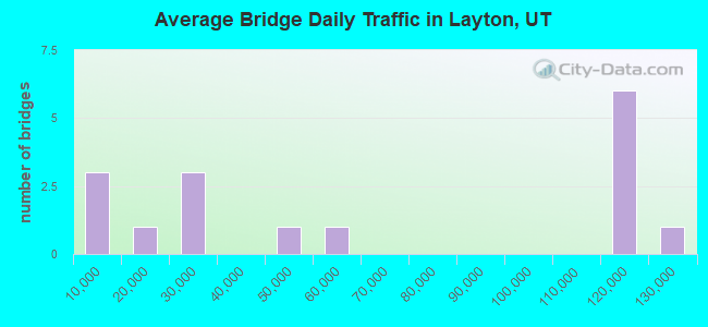
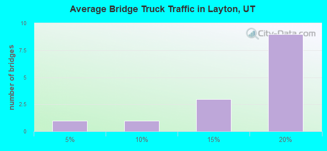
- 16Number of bridges
- 207ft / 63.1mTotal length
- 1,010,046Total average daily traffic
- 161,473Total average daily truck traffic
- National Bridge Inventory (NBI) Registered Bridges for Layton
- No street view available for this location
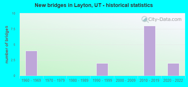
- New bridges - historical statistics
- 41960-1969
- 21990-1999
- 82010-2019
- 22020-2022
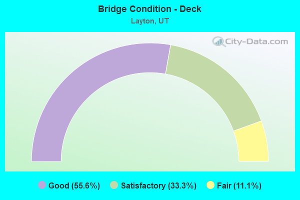
- Bridge Condition - Deck
- 55.6%Good
- 33.3%Satisfactory
- 11.1%Fair
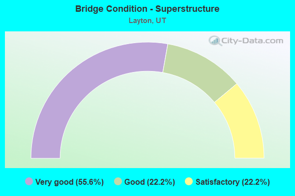
- Bridge Condition - Superstructure
- 55.6%Very good
- 22.2%Good
- 22.2%Satisfactory
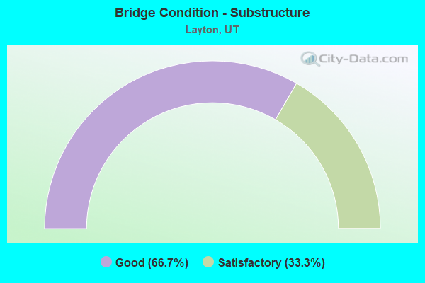
- Bridge Condition - Substructure
- 66.7%Good
- 33.3%Satisfactory
Find on map >> Show street view
Structure Number: C 483, Location: GENTILE ST IN LAYTON (Lat: 41.060147, Lng: -111.964450), Route carried "on" structure: State highway 109, Year Built: 1966, Status: Open, Structure Length: 8.50m (27.89ft), Average Daily Traffic: 13,752 (year 2020), Truck Traffic: 10%, Average Future Daily Traffic: 17,190 (year 2040), Design Load: HS 20+Mod, Features Intersected: I-15 (SR-15) NBL & S
Minimum Vertical Clearance: 30+ m (98+ ft), Kilometerpoint: 0.153, Lanes on structure: 4, Lanes under structure: 6, Owner: State Highway Agency, Approaching Roadway Width: 17.1m (56.1ft), Skew: 14 degrees, Material/Design: Steel continuous, Design/Construction: Stringer/Multi-beam, Number Of Spans In Main Unit: 4, Length of Maximum Span: 29.1m (95.5ft), Curb or Sidewalk Widths: Left: 1.8m (5.9ft), Right: 1.8m (5.9ft), Curb-To-Curb Width: 17.1m (56.1ft), Out-to-Out Width: 20.7m (67.9ft)
Condition: Deck: Good, Superstructure: Satisfactory, Substructure: Satisfactory, Operating Rating: 35.0 metric tons, Method Used To Determine Operating Rating: Load Factor (LF) rating reported by rating factor (RF) method using MS18 loading, Inventory Rating: 34.7 metric tons, Method Used To Determine Inventory Rating: Load Factor (LF) rating reported by rating factor (RF) method using MS18 loading, Structural Evaluation: Equal to present minimum criteria, Deck Geometry: Somewhat better than minimum adequacy, Underclear: Meets minimum limits, Approach Roadway Alignment: Equal to present minimum criteria, Designated Inspection Frequency: Every 24 months, Inspection Date: June 2021, Deck Structure Type: Concrete Cast-file-Place, Wearing Surface/Protective System: Wearing Surface: Epoxy Overlay
Find on map >> Show street view
Structure Number: C 986, Location: At the SOUTH LAYTON INT. (Lat: 41.056078, Lng: -111.960431), Route carried "on" structure: State highway 126, Year Built: 2011, Status: Open, Structure Length: 6.49m (21.29ft), Average Daily Traffic: 21,141 (year 2020), Truck Traffic: 11%, Average Future Daily Traffic: 26,426 (year 2040), Design Load: HS 25 or greater, Features Intersected: I-15, (SR-15)
Minimum Vertical Clearance: 5.49m (18.01ft), Kilometerpoint: 0.231, Lanes on structure: 6, Lanes under structure: 8, Owner: State Highway Agency, Approaching Roadway Width: 40.2m (131.9ft), Skew: 20 degrees, Material/Design: Steel continuous, Design/Construction: Stringer/Multi-beam, Number Of Spans In Main Unit: 2, Length of Maximum Span: 32.9m (107.9ft), Curb-To-Curb Width: 40.2m (131.9ft), Out-to-Out Width: 81.1m (266.1ft)
Condition: Deck: Good, Superstructure: Very good, Substructure: Good, Operating Rating: 37.9 metric tons, Method Used To Determine Operating Rating: Load and Resistance Factor Rating (LRFR) rating reported by rating factor(RF) method using HL-93 loadings, Inventory Rating: 29.5 metric tons, Method Used To Determine Inventory Rating: Load and Resistance Factor Rating (LRFR) rating reported by rating factor(RF) method using HL-93 loadings, Structural Evaluation: Better than present minimum criteria, Deck Geometry: Superior to present desirable criteria, Underclear: Equal to present minimum criteria, Approach Roadway Alignment: Equal to present desirable criteria, Designated Inspection Frequency: Every 24 months, Inspection Date: June 2021, Deck Structure Type: Concrete Cast-file-Place, Wearing Surface/Protective System: Wearing Surface: Epoxy Overlay, Deck Protection: Epoxy Coated Reinforcing
Find on map >> Show street view
Structure Number: C1006, Location: West of the So.Layton Int (Lat: 41.055589, Lng: -111.964686), Route carried "on" structure: State highway 1435, Year Built: 2010, Status: Open, Structure Length: 5.34m (17.52ft), Average Daily Traffic: 1,002 (year 2020), Average Future Daily Traffic: 1,253 (year 2040), Design Load: HL 93, Features Intersected: UPRR & UTA TRACKS, Facility Carried by Structure: LAYTON PKWY SR-126
Minimum Vertical Clearance: 30+ m (98+ ft), Kilometerpoint: 4.437, Lanes on structure: 7, Owner: State Highway Agency, Approaching Roadway Width: 29.9m (98.1ft), Skew: 2 degrees, Material/Design: Steel, Design/Construction: Stringer/Multi-beam, Number Of Spans In Main Unit: 1, Length of Maximum Span: 52.4m (171.9ft), Curb or Sidewalk Widths: Left: 0.0m, Right: 2.6m (8.5ft), Curb-To-Curb Width: 29.9m (98.1ft), Out-to-Out Width: 33.7m (110.6ft)
Condition: Deck: Satisfactory, Superstructure: Good, Substructure: Good, Operating Rating: 59.3 metric tons, Method Used To Determine Operating Rating: Load and Resistance Factor Rating (LRFR) rating reported by rating factor(RF) method using HL-93 loadings, Inventory Rating: 35.0 metric tons, Method Used To Determine Inventory Rating: Load and Resistance Factor Rating (LRFR) rating reported by rating factor(RF) method using HL-93 loadings, Structural Evaluation: Better than present minimum criteria, Deck Geometry: Equal to present minimum criteria, Underclear: Equal to present minimum criteria, Approach Roadway Alignment: Equal to present desirable criteria, Designated Inspection Frequency: Every 24 months, Inspection Date: May 2021, Deck Structure Type: Concrete Cast-file-Place, Wearing Surface/Protective System: Wearing Surface: Epoxy Overlay, Deck Protection: Epoxy Coated Reinforcing
Find on map >> Show street view
Structure Number: C104, Location: 1400 N 1100 W Layton City (Lat: 41.080197, Lng: -111.273806), Route carried "on" structure: Alternate City street , Year Built: 2018, Status: Open, Structure Length: 8.93m (29.30ft), Average Daily Traffic: 9,600 (year 2020), Truck Traffic: 2%, Average Future Daily Traffic: 12,900 (year 2040), Design Load: HL 93, Features Intersected: I-15 (SR-15), Facility Carried by Structure: Midtown Crossing
Minimum Vertical Clearance: 30+ m (98+ ft), Kilometerpoint: 0.000, Lanes on structure: 2, Lanes under structure: 8, Owner: State Highway Agency, Approaching Roadway Width: 13.4m (44.0ft), Material/Design: Steel, Design/Construction: Stringer/Multi-beam, Number Of Spans In Main Unit: 2, Length of Maximum Span: 54.3m (178.1ft), Curb or Sidewalk Widths: Left: 0.0m, Right: 2.0m (6.6ft), Curb-To-Curb Width: 13.4m (44.0ft), Out-to-Out Width: 16.2m (53.1ft)
Condition: Deck: Satisfactory, Superstructure: Very good, Substructure: Good, Operating Rating: 55.1 metric tons, Method Used To Determine Operating Rating: Load and Resistance Factor Rating (LRFR) rating reported by rating factor(RF) method using HL-93 loadings, Inventory Rating: 42.1 metric tons, Method Used To Determine Inventory Rating: Load and Resistance Factor Rating (LRFR) rating reported by rating factor(RF) method using HL-93 loadings, Structural Evaluation: Better than present minimum criteria, Deck Geometry: Equal to present minimum criteria, Underclear: Equal to present minimum criteria, Approach Roadway Alignment: Equal to present desirable criteria, Designated Inspection Frequency: Every 24 months, Inspection Date: June 2021, Deck Structure Type: Concrete Cast-file-Place, Wearing Surface/Protective System: Wearing Surface: Epoxy Overlay, Deck Protection: Epoxy Coated Reinforcing
Find on map >> Show street view
Structure Number: F 171, Location: Syracuse Rd.Int.in Layton (Lat: 41.089219, Lng: -111.990117), Route carried "on" structure: State highway 108, Year Built: 1967, Year Reconstructed: 1982, Status: Open, Structure Length: 9.15m (30.02ft), Average Daily Traffic: 53,379 (year 2020), Truck Traffic: 9%, Average Future Daily Traffic: 66,724 (year 2040), Design Load: HS 20+Mod, Features Intersected: I-15 (SR-15) NBL AND SBL
Minimum Vertical Clearance: 30+ m (98+ ft), Kilometerpoint: 0.196, Lanes on structure: 6, Lanes under structure: 6, Owner: State Highway Agency, Approaching Roadway Width: 24.6m (80.7ft), Skew: 3 degrees, Material/Design: Prestressed concrete continuous, Design/Construction: Stringer/Multi-beam, Number Of Spans In Main Unit: 4, Length of Maximum Span: 27.4m (89.9ft), Curb or Sidewalk Widths: Left: 0.0m, Right: 2.7m (8.9ft), Curb-To-Curb Width: 24.6m (80.7ft), Out-to-Out Width: 28.0m (91.9ft)
Condition: Deck: Satisfactory, Superstructure: Satisfactory, Substructure: Satisfactory, Operating Rating: 38.9 metric tons, Method Used To Determine Operating Rating: Load and Resistance Factor Rating (LRFR) rating reported by rating factor(RF) method using HL-93 loadings, Inventory Rating: 8.7 metric tons, Method Used To Determine Inventory Rating: Load Factor (LF) rating reported by rating factor (RF) method using MS18 loading, Structural Evaluation: High priority of corrective action, Deck Geometry: Somewhat better than minimum adequacy, Underclear: Meets minimum limits, Approach Roadway Alignment: Equal to present desirable criteria, Designated Inspection Frequency: Every 24 months, Inspection Date: May 2021, Deck Structure Type: Concrete Cast-file-Place, Wearing Surface/Protective System: Wearing Surface: Bituminous, Deck Protection: Epoxy Coated Reinforcing
Find on map >> Show street view
Structure Number: F 575, Location: SR193/SR89 INTCHG. LAYTON (Lat: 41.107686, Lng: -111.910347), Route carried "on" structure: State highway 193, Year Built: 1995, Status: Open, Structure Length: 5.44m (17.85ft), Average Daily Traffic: 25,775 (year 2020), Truck Traffic: 10%, Average Future Daily Traffic: 32,219 (year 2040), Design Load: HS 20+Mod, Features Intersected: US-89, (SR-89)
Minimum Vertical Clearance: 30+ m (98+ ft), Kilometerpoint: 15.113, Lanes on structure: 4, Lanes under structure: 6, Base Highway Network: Yes, Owner: State Highway Agency, Approaching Roadway Width: 18.9m (62.0ft), Material/Design: Prestressed concrete continuous, Design/Construction: Stringer/Multi-beam, Number Of Spans In Main Unit: 2, Length of Maximum Span: 34.4m (112.9ft), Curb-To-Curb Width: 18.9m (62.0ft), Out-to-Out Width: 19.9m (65.3ft)
Condition: Deck: Fair, Superstructure: Good, Substructure: Satisfactory, Operating Rating: 48.3 metric tons, Method Used To Determine Operating Rating: Load and Resistance Factor Rating (LRFR) rating reported by rating factor(RF) method using HL-93 loadings, Inventory Rating: 38.2 metric tons, Method Used To Determine Inventory Rating: Load Factor (LF) rating reported by rating factor (RF) method using MS18 loading, Structural Evaluation: Equal to present minimum criteria, Deck Geometry: Equal to present minimum criteria, Underclear: Meets minimum limits, Approach Roadway Alignment: Equal to present desirable criteria, Designated Inspection Frequency: Every 24 months, Inspection Date: June 2021, Deck Structure Type: Concrete Cast-file-Place, Wearing Surface/Protective System: Wearing Surface: Epoxy Overlay, Membrane: Epoxy, Deck Protection: Epoxy Coated Reinforcing
Find on map >> Show street view
Structure Number: 1C1032, Location: Hill Field Rd Interchange (Lat: 41.073711, Lng: -111.976367), Route carried "on" structure: Interstate 15, Year Built: 2016, Status: Open, Structure Length: 5.53m (18.14ft), Average Daily Traffic: 113,497 (year 2020), Truck Traffic: 17%, Average Future Daily Traffic: 141,871 (year 2040), Design Load: HL 93, Features Intersected: SR-232 Hill Field Rd
Minimum Vertical Clearance: 30.17m (98.98ft), Kilometerpoint: 534.107, Lanes on structure: 3, Lanes under structure: 6, Base Highway Network: Yes, Owner: State Highway Agency, Approaching Roadway Width: 26.5m (86.9ft), Material/Design: Steel, Design/Construction: Stringer/Multi-beam, Number Of Spans In Main Unit: 1, Length of Maximum Span: 55.3m (181.4ft), Curb or Sidewalk Widths: Left: 1.5m (4.9ft), Right: 1.5m (4.9ft), Curb-To-Curb Width: 26.5m (86.9ft), Out-to-Out Width: 27.2m (89.2ft)
Condition: Deck: Good, Superstructure: Very good, Substructure: Good, Operating Rating: 58.6 metric tons, Method Used To Determine Operating Rating: Load and Resistance Factor Rating (LRFR) rating reported by rating factor(RF) method using HL-93 loadings, Inventory Rating: 42.8 metric tons, Method Used To Determine Inventory Rating: Load and Resistance Factor Rating (LRFR) rating reported by rating factor(RF) method using HL-93 loadings, Structural Evaluation: Better than present minimum criteria, Deck Geometry: Superior to present desirable criteria, Underclear: Superior to present desirable criteria, Approach Roadway Alignment: Equal to present desirable criteria, Designated Inspection Frequency: Every 24 months, Inspection Date: June 2021, Deck Structure Type: Concrete Cast-file-Place, Wearing Surface/Protective System: Wearing Surface: Epoxy Overlay, Deck Protection: Epoxy Coated Reinforcing
Find on map >> Show street view
Structure Number: 3C1032, Location: Hill Field Rd Interchange (Lat: 41.074628, Lng: -111.977536), Route carried "on" structure: Interstate 15, Year Built: 2016, Status: Open, Structure Length: 5.53m (18.14ft), Average Daily Traffic: 113,497 (year 2020), Truck Traffic: 17%, Average Future Daily Traffic: 141,871 (year 2040), Design Load: HL 93, Features Intersected: SR-232 Hill Field Rd
Minimum Vertical Clearance: 30+ m (98+ ft), Kilometerpoint: 534.037, Lanes on structure: 3, Lanes under structure: 9, Base Highway Network: Yes, Owner: State Highway Agency, Approaching Roadway Width: 26.5m (86.9ft), Skew: 9 degrees, Material/Design: Steel, Design/Construction: Stringer/Multi-beam, Number Of Spans In Main Unit: 1, Length of Maximum Span: 0.0m, Curb or Sidewalk Widths: Left: 1.5m (4.9ft), Right: 1.5m (4.9ft), Curb-To-Curb Width: 26.5m (86.9ft), Out-to-Out Width: 27.4m (89.9ft)
Condition: Deck: Good, Superstructure: Very good, Substructure: Good, Operating Rating: 65.1 metric tons, Method Used To Determine Operating Rating: Load and Resistance Factor Rating (LRFR) rating reported by rating factor(RF) method using HL-93 loadings, Inventory Rating: 42.8 metric tons, Method Used To Determine Inventory Rating: Load and Resistance Factor Rating (LRFR) rating reported by rating factor(RF) method using HL-93 loadings, Structural Evaluation: Better than present minimum criteria, Deck Geometry: Superior to present desirable criteria, Underclear: Superior to present desirable criteria, Approach Roadway Alignment: Equal to present desirable criteria, Designated Inspection Frequency: Every 24 months, Inspection Date: June 2021, Deck Structure Type: Concrete Cast-file-Place, Wearing Surface/Protective System: Wearing Surface: Epoxy Overlay, Deck Protection: Epoxy Coated Reinforcing
Find on map >> Show street view
Structure Number: C1052, Location: Church Street over I-15 (Lat: 41.063125, Lng: -111.967264), Route carried "on" structure: City street 1462, Year Built: 2020, Status: Open, Structure Length: 8.15m (26.74ft), Average Daily Traffic: 6,558 (year 2020), Average Future Daily Traffic: 8,198 (year 2040), Design Load: HL 93, Features Intersected: I-15 (SR-15) NBL and SBL, Facility Carried by Structure: Church Street
Minimum Vertical Clearance: 30.48m (100.00ft), Kilometerpoint: 532.242, Lanes on structure: 2, Lanes under structure: 9, Owner: State Highway Agency, Approaching Roadway Width: 11.6m (38.1ft), Skew: 3 degrees, Material/Design: Steel, Design/Construction: Stringer/Multi-beam, Number Of Spans In Main Unit: 2, Length of Maximum Span: 40.2m (131.9ft), Curb or Sidewalk Widths: Left: 2.0m (6.6ft), Right: 2.0m (6.6ft), Curb-To-Curb Width: 11.6m (38.1ft), Out-to-Out Width: 16.5m (54.1ft)
Condition: Deck: Good, Superstructure: Very good, Substructure: Good, Operating Rating: 45.7 metric tons, Method Used To Determine Operating Rating: Load and Resistance Factor Rating (LRFR) rating reported by rating factor(RF) method using HL-93 loadings, Inventory Rating: 35.3 metric tons, Method Used To Determine Inventory Rating: Load and Resistance Factor Rating (LRFR) rating reported by rating factor(RF) method using HL-93 loadings, Structural Evaluation: Better than present minimum criteria, Deck Geometry: Somewhat better than minimum adequacy, Underclear: Meets minimum limits, Approach Roadway Alignment: Equal to present desirable criteria, Designated Inspection Frequency: Every 24 months, Inspection Date: June 2021, Deck Structure Type: Concrete Cast-file-Place, Wearing Surface/Protective System: Wearing Surface: Epoxy Overlay, Deck Protection: Epoxy Coated Reinforcing
Find on map >> Show street view
Structure Number: C 483, Location: GENTILE ST IN LAYTON (Lat: 41.060147, Lng: -111.964450), Route carried "under" structure: Interstate 15, Year Built: 1966, Structure Length: 0. m, Average Daily Traffic: 113,497 (year 2020), Truck Traffic: 17%, Features Intersected: I-15 (SR-15) NBL & S, Facility Carried by Structure: SR-109,GENTILE ST.
Minimum Vertical Clearance: 4.98m (16.34ft), Kilometerpoint: 531.743, Lanes on structure: 4, Lanes under structure: 6, Material/Design: Steel continuous, Design/Construction: Stringer/Multi-beam, Length of Maximum Span: 29.1m (95.5ft)
Find on map >> Show street view
Structure Number: C 986, Location: At the SOUTH LAYTON INT. (Lat: 41.056078, Lng: -111.960431), Route carried "under" structure: Interstate 15, Year Built: 2011, Structure Length: 0. m, Average Daily Traffic: 125,562 (year 2020), Truck Traffic: 18%, Features Intersected: I-15, (SR-15), Facility Carried by Structure: SR-126, Int.X-road
Minimum Vertical Clearance: 6.01m (19.72ft), Kilometerpoint: 531.112, Lanes on structure: 6, Lanes under structure: 8, Material/Design: Steel continuous, Design/Construction: Stringer/Multi-beam, Length of Maximum Span: 32.9m (107.9ft)
Find on map >> Show street view
Structure Number: C104, Location: 1400 N 1100 W Layton City (Lat: 41.080197, Lng: -111.273806), Route carried "under" structure: Interstate 15, Year Built: 2018, Structure Length: 0. m, Average Daily Traffic: 113,974 (year 2020), Truck Traffic: 17%, Features Intersected: I-15 (SR-15), Facility Carried by Structure: Midtown Crossing
Minimum Vertical Clearance: 5.69m (18.67ft), Kilometerpoint: 534.463, Lanes on structure: 2, Lanes under structure: 8, Material/Design: Steel, Design/Construction: Stringer/Multi-beam, Length of Maximum Span: 54.3m (178.1ft)
Find on map >> Show street view
Structure Number: F 171, Location: Syracuse Rd.Int.in Layton (Lat: 41.089219, Lng: -111.990117), Route carried "under" structure: Interstate 15, Year Built: 1967, Structure Length: 0. m, Average Daily Traffic: 113,974 (year 2020), Truck Traffic: 17%, Features Intersected: I-15 (SR-15) NBL AND SBL, Facility Carried by Structure: SR-108,SYRACUSE RD
Minimum Vertical Clearance: 5.05m (16.57ft), Kilometerpoint: 535.722, Lanes on structure: 6, Lanes under structure: 6, Material/Design: Prestressed concrete continuous, Design/Construction: Stringer/Multi-beam, Length of Maximum Span: 27.4m (89.9ft)
Find on map >> Show street view
Structure Number: F 575, Location: SR193/SR89 INTCHG. LAYTON (Lat: 41.107686, Lng: -111.910347), Route carried "under" structure: US 89, Year Built: 1995, Structure Length: 0. m, Average Daily Traffic: 45,397 (year 2020), Truck Traffic: 16%, Features Intersected: US-89, (SR-89), Facility Carried by Structure: SR-193,INT. X-ROAD
Minimum Vertical Clearance: 5.16m (16.93ft), Kilometerpoint: 650.651, Lanes on structure: 4, Lanes under structure: 6, Material/Design: Prestressed concrete continuous, Design/Construction: Stringer/Multi-beam, Length of Maximum Span: 34.4m (112.9ft)
Find on map >> Show street view
Structure Number: 3C1032, Location: Hill Field Rd Interchange (Lat: 41.074628, Lng: -111.977536), Route carried "under" structure: State highway 232, Year Built: 2016, Structure Length: 0. m, Average Daily Traffic: 25,944 (year 2020), Truck Traffic: 17%, Features Intersected: SR-232 Hill Field Rd, Facility Carried by Structure: I-15
Minimum Vertical Clearance: 5.28m (17.32ft), Kilometerpoint: 0.161, Lanes on structure: 3, Lanes under structure: 9, Material/Design: Steel, Design/Construction: Stringer/Multi-beam, Length of Maximum Span: 0.0m
Find on map >> Show street view
Structure Number: C1052, Location: Church Street over I-15 (Lat: 41.063125, Lng: -111.967264), Route carried "under" structure: Interstate 15, Year Built: 2020, Structure Length: 0. m, Average Daily Traffic: 113,497 (year 2020), Truck Traffic: 17%, Features Intersected: I-15 (SR-15) NBL and SBL, Facility Carried by Structure: Church Street
Minimum Vertical Clearance: 5.58m (18.31ft), Kilometerpoint: 532.242, Lanes on structure: 2, Lanes under structure: 9, Material/Design: Steel, Design/Construction: Stringer/Multi-beam, Length of Maximum Span: 40.2m (131.9ft)