Bridge Statistics for Lawrenceville, Pennsylvania (PA)
Condition, Traffic, Stress, Structural Evaluation, Project Costs
- National Bridge Inventory (NBI) Statistics
- 19Number of bridges
- 367ft / 112mTotal length
- $170,000Total costs
- 44,313Total average daily traffic
- 9,390Total average daily truck traffic
- National Bridge Inventory (NBI) Registered Bridges for Lawrenceville
- No street view available for this location
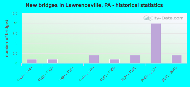
- New bridges - historical statistics
- 11940-1949
- 11950-1959
- 21970-1979
- 11980-1989
- 21990-1999
- 102000-2009
- 22010-2019


- Bridge Condition - Deck
- 16.7%Very good
- 58.3%Good
- 16.7%Satisfactory
- 8.3%Fair

- Bridge Condition - Superstructure
- 41.7%Very good
- 41.7%Good
- 8.3%Satisfactory
- 8.3%Fair

- Bridge Condition - Substructure
- 25.0%Very good
- 50.0%Good
- 16.7%Satisfactory
- 8.3%Fair

- Bridge Condition - Channel
- 36.4%Very good
- 9.1%Good
- 9.1%Satisfactory
- 36.4%Fair
- 9.1%Poor

- Bridge Condition - Culverts
- 66.7%Very good
- 33.3%Satisfactory
Find on map >> Show street view
Structure Number: 32813, Location: 1 MI S OF LAWRENCEVILLE (Lat: 41.977861, Lng: -77.115761), Route carried "on" structure: State highway 287, Year Built: 1942, Status: Open, Structure Length: 1.13m (3.71ft), Average Daily Traffic: 3,430 (year 2022), Truck Traffic: 9%, Average Future Daily Traffic: 4,479 (year 2032), Features Intersected: OVER SMITH CREEK, Facility Carried by Structure: SR 0015
Minimum Vertical Clearance: 30+ m (98+ ft), Kilometerpoint: 56.725, Lanes on structure: 2, Base Highway Network: Yes, Owner: State Highway Agency, Approaching Roadway Width: 11.3m (37.1ft), Material/Design: Concrete, Design/Construction: Tee Beam, Number Of Spans In Main Unit: 1, Length of Maximum Span: 11.0m (36.1ft), Curb-To-Curb Width: 11.6m (38.1ft), Out-to-Out Width: 12.7m (41.7ft)
Condition: Deck: Fair, Superstructure: Fair, Substructure: Fair, Channel: Poor, Operating Rating: 50.8 metric tons, Method Used To Determine Operating Rating: Load Factor (LF), Inventory Rating: 29.9 metric tons, Method Used To Determine Inventory Rating: Load Factor (LF), Structural Evaluation: Somewhat better than minimum adequacy, Deck Geometry: Somewhat better than minimum adequacy, Waterway Adequacy: Equal to present minimum criteria, Approach Roadway Alignment: Equal to present desirable criteria, Length Of Structure Improvement: 1.20m (3.94ft), Designated Inspection Frequency: Every 24 months, Other Special Inspection Frequency: Every 6 months, Inspection Date: June 2021, Other Special Inspection Date: December 2021, Bridge Improvement Cost: $13,000, Roadway Improvement Cost: $50,000, Total Project Cost: $170,000, Deck Structure Type: Concrete Cast-file-Place, Wearing Surface/Protective System: Wearing Surface: Bituminous, Membrane: Preformed Fabric
Find on map >> Show street view
Structure Number: 32814, Location: LAWRENCEVILLE-TIOGA RIVER (Lat: 41.986667, Lng: -77.131667), Route carried "on" structure: State highway 287, Year Built: 1994, Status: Open, Structure Length: 11.92m (39.11ft), Average Daily Traffic: 3,430 (year 2022), Truck Traffic: 9%, Average Future Daily Traffic: 4,479 (year 2032), Design Load: HS 25 or greater, Features Intersected: OVER TIOGA RIVER, Facility Carried by Structure: US SR 15
Minimum Vertical Clearance: 30+ m (98+ ft), Kilometerpoint: 58.448, Lanes on structure: 2, Base Highway Network: Yes, Owner: State Highway Agency, Approaching Roadway Width: 12.8m (42.0ft), Skew: 6 degrees, Material/Design: Prestressed concrete continuous, Design/Construction: Stringer/Multi-beam, Number Of Spans In Main Unit: 3, Length of Maximum Span: 38.1m (125.0ft), Curb or Sidewalk Widths: Left: 0.2m (0.7ft), Right: 0.2m (0.7ft), Curb-To-Curb Width: 13.4m (44.0ft), Out-to-Out Width: 14.5m (47.6ft)
Condition: Deck: Good, Superstructure: Very good, Substructure: Good, Channel: Good, Operating Rating: 99.8 metric tons, Method Used To Determine Operating Rating: Load Factor (LF), Inventory Rating: 40.8 metric tons, Method Used To Determine Inventory Rating: Load Factor (LF), Structural Evaluation: Better than present minimum criteria, Deck Geometry: Better than present minimum criteria, Waterway Adequacy: Superior to present desirable criteria, Approach Roadway Alignment: Equal to present desirable criteria, Length Of Structure Improvement: 11.90m (39.04ft), Designated Inspection Frequency: Every 48 months, Inspection Date: June 2019, Deck Structure Type: Concrete Cast-file-Place, Wearing Surface/Protective System: Wearing Surface: Epoxy Overlay, Deck Protection: Epoxy Coated Reinforcing
Find on map >> Show street view
Structure Number: 32837, Location: 4 MI W OF LAWRENCEVILLE (Lat: 41.970192, Lng: -77.191603), Route carried "on" structure: State highway 49, Year Built: 1976, Status: Open, Structure Length: 9.39m (30.81ft), Average Daily Traffic: 4,017 (year 2021), Truck Traffic: 11%, Average Future Daily Traffic: 5,861 (year 2032), Design Load: HS 20, Features Intersected: OVER BALDWIN CREEK
Minimum Vertical Clearance: 30+ m (98+ ft), Kilometerpoint: 37.459, Lanes on structure: 2, Base Highway Network: Yes, Owner: State Highway Agency, Approaching Roadway Width: 13.4m (44.0ft), Material/Design: Steel continuous, Design/Construction: Stringer/Multi-beam, Number Of Spans In Main Unit: 3, Length of Maximum Span: 37.2m (122.0ft), Curb or Sidewalk Widths: Left: 0.2m (0.7ft), Right: 0.2m (0.7ft), Curb-To-Curb Width: 14.6m (47.9ft), Out-to-Out Width: 15.7m (51.5ft)
Condition: Deck: Good, Superstructure: Satisfactory, Substructure: Satisfactory, Channel: Very good, Operating Rating: 66.2 metric tons, Method Used To Determine Operating Rating: Load Factor (LF), Inventory Rating: 39.9 metric tons, Method Used To Determine Inventory Rating: Load Factor (LF), Structural Evaluation: Equal to present minimum criteria, Deck Geometry: Superior to present desirable criteria, Waterway Adequacy: Superior to present desirable criteria, Approach Roadway Alignment: Equal to present desirable criteria, Length Of Structure Improvement: 10.40m (34.12ft), Designated Inspection Frequency: Every 48 months, Underwater Inspection Frequency: Every 60 months, Inspection Date: June 2019, Underwater Inspection Date: July 2021, Deck Structure Type: Concrete Cast-file-Place, Wearing Surface/Protective System: Wearing Surface: Epoxy Overlay, Deck Protection: Epoxy Coated Reinforcing
Find on map >> Show street view
Structure Number: 32979, Location: BORO OF LAWRENCEVILLE (Lat: 41.999617, Lng: -77.114431), Route carried "on" structure: State highway , Year Built: 1986, Status: Open, Structure Length: 6.49m (21.29ft), Average Daily Traffic: 382 (year 2020), Truck Traffic: 7%, Average Future Daily Traffic: 576 (year 2032), Features Intersected: OVER TIOGA RIVER, Facility Carried by Structure: SR 1015
Minimum Vertical Clearance: 30+ m (98+ ft), Kilometerpoint: 2.287, Lanes on structure: 2, Owner: State Highway Agency, Approaching Roadway Width: 8.2m (26.9ft), Skew: 2 degrees, Material/Design: Prestressed concrete, Design/Construction: Box Beam or Girders - Single/Spread, Number Of Spans In Main Unit: 3, Length of Maximum Span: 21.6m (70.9ft), Curb-To-Curb Width: 8.5m (27.9ft), Out-to-Out Width: 9.3m (30.5ft)
Condition: Deck: Satisfactory, Superstructure: Good, Substructure: Good, Channel: Satisfactory, Operating Rating: 83.5 metric tons, Method Used To Determine Operating Rating: Load Factor (LF), Inventory Rating: 36.3 metric tons, Method Used To Determine Inventory Rating: Load Factor (LF), Structural Evaluation: Better than present minimum criteria, Deck Geometry: Equal to present minimum criteria, Waterway Adequacy: Superior to present desirable criteria, Approach Roadway Alignment: Better than present minimum criteria, Length Of Structure Improvement: 7.50m (24.61ft), Designated Inspection Frequency: Every 48 months, Inspection Date: June 2019, Deck Structure Type: Concrete Cast-file-Place, Wearing Surface/Protective System: Wearing Surface: Epoxy Overlay, Deck Protection: Epoxy Coated Reinforcing
Find on map >> Show street view
Structure Number: 32993, Location: 1.5 MI NE OF SOMMERS LANE (Lat: 41.973956, Lng: -77.088608), Route carried "on" structure: State highway , Year Built: 1959, Status: Open, Structure Length: 1.07m (3.51ft), Average Daily Traffic: 304 (year 2021), Truck Traffic: 5%, Average Future Daily Traffic: 447 (year 2032), Features Intersected: OVER HART'S CREEK, Facility Carried by Structure: SR 1026
Minimum Vertical Clearance: 30+ m (98+ ft), Kilometerpoint: 1.997, Lanes on structure: 2, Owner: State Highway Agency, Approaching Roadway Width: 5.2m (17.1ft), Skew: 5 degrees, Material/Design: Concrete, Design/Construction: Tee Beam, Number Of Spans In Main Unit: 1, Length of Maximum Span: 9.8m (32.2ft), Curb or Sidewalk Widths: Left: 0.5m (1.6ft), Right: 0.5m (1.6ft), Curb-To-Curb Width: 8.7m (28.5ft), Out-to-Out Width: 9.9m (32.5ft)
Condition: Deck: Satisfactory, Superstructure: Good, Substructure: Satisfactory, Channel: Fair, Operating Rating: 70.8 metric tons, Method Used To Determine Operating Rating: Load Factor (LF), Inventory Rating: 41.7 metric tons, Method Used To Determine Inventory Rating: Load Factor (LF), Structural Evaluation: Equal to present minimum criteria, Deck Geometry: Equal to present minimum criteria, Waterway Adequacy: Better than present minimum criteria, Approach Roadway Alignment: Equal to present desirable criteria, Length Of Structure Improvement: 1.70m (5.58ft), Designated Inspection Frequency: Every 24 months, Inspection Date: June 2021, Deck Structure Type: Concrete Cast-file-Place, Wearing Surface/Protective System: Wearing Surface: Bituminous
Find on map >> Show street view
Structure Number: 3328, Location: 0.4 MI. W. TIOGA JUNCTION (Lat: 41.957469, Lng: -77.115544), Route carried "on" structure: City street , Year Built: 1993, Status: Open, Structure Length: 6.55m (21.49ft), Average Daily Traffic: 250 (year 2021), Truck Traffic: 15%, Average Future Daily Traffic: 387 (year 2043), Design Load: HS 25 or greater, Features Intersected: TIOGA RIVER, Facility Carried by Structure: T-773 CTY BDG #10
Minimum Vertical Clearance: 30+ m (98+ ft), Kilometerpoint: 0.000, Lanes on structure: 2, Owner: County Highway Agency, Approaching Roadway Width: 7.6m (24.9ft), Skew: 2 degrees, Material/Design: Prestressed concrete continuous, Design/Construction: Stringer/Multi-beam, Number Of Spans In Main Unit: 2, Length of Maximum Span: 32.0m (105.0ft), Curb or Sidewalk Widths: Left: 0.2m (0.7ft), Right: 0.2m (0.7ft), Curb-To-Curb Width: 8.5m (27.9ft), Out-to-Out Width: 9.6m (31.5ft)
Condition: Deck: Good, Superstructure: Good, Substructure: Good, Channel: Fair, Inventory Rating: 47.2 metric tons, Method Used To Determine Inventory Rating: Load Factor (LF), Structural Evaluation: Better than present minimum criteria, Deck Geometry: Equal to present minimum criteria, Waterway Adequacy: Equal to present desirable criteria, Approach Roadway Alignment: Better than present minimum criteria, Length Of Structure Improvement: 6.60m (21.65ft), Designated Inspection Frequency: Every 24 months, Inspection Date: June 2021, Deck Structure Type: Concrete Cast-file-Place, Wearing Surface/Protective System: Wearing Surface: Monolithic Concrete, Deck Protection: Epoxy Coated Reinforcing
Find on map >> Show street view
Structure Number: 33281, Location: 1.2 MI. E. TIOGA JUNCTION (Lat: 41.953497, Lng: -77.083694), Route carried "on" structure: City street , Year Built: 1974, Status: Open, Structure Length: 0.67m (2.20ft), Average Daily Traffic: 150 (year 2021), Truck Traffic: 5%, Average Future Daily Traffic: 232 (year 2043), Features Intersected: MUTTON LANE CREEK, Facility Carried by Structure: T-787 LAWRENCE TWP
Minimum Vertical Clearance: 30+ m (98+ ft), Kilometerpoint: 0.000, Lanes on structure: 2, Owner: Town or Township Highway Agency, Approaching Roadway Width: 5.8m (19.0ft), Material/Design: Concrete, Design/Construction: Culvert, Number Of Spans In Main Unit: 1, Length of Maximum Span: 6.1m (20.0ft), Curb-To-Curb Width: 6.7m (22.0ft), Out-to-Out Width: 7.7m (25.3ft)
Condition: Channel: Fair, Culverts: Satisfactory, Operating Rating: 53.5 metric tons, Method Used To Determine Operating Rating: Load Factor (LF), Inventory Rating: 31.8 metric tons, Method Used To Determine Inventory Rating: Load Factor (LF), Structural Evaluation: Equal to present minimum criteria, Deck Geometry: Meets minimum limits, Waterway Adequacy: Better than present minimum criteria, Approach Roadway Alignment: Equal to present desirable criteria, Length Of Structure Improvement: 0.70m (2.30ft), Designated Inspection Frequency: Every 24 months, Inspection Date: June 2021, Wearing Surface/Protective System: Wearing Surface: Monolithic Concrete
Find on map >> Show street view
Structure Number: 45153, Location: BORO OF LAWRENCEVILLE (Lat: 41.997183, Lng: -77.137764), Route carried "on" structure: US 15, Year Built: 2008, Status: Open, Structure Length: 33.35m (109.42ft), Average Daily Traffic: 3,846 (year 2021), Truck Traffic: 33%, Average Future Daily Traffic: 4,668 (year 2032), Design Load: HL 93, Features Intersected: SR 4022 & COWANESQUE RIV
Minimum Vertical Clearance: 30+ m (98+ ft), Kilometerpoint: 56.008, Lanes on structure: 2, Lanes under structure: 2, Base Highway Network: Yes, Owner: State Highway Agency, Approaching Roadway Width: 15.8m (51.8ft), Material/Design: Prestressed concrete continuous, Design/Construction: Stringer/Multi-beam, Number Of Spans In Main Unit: 8, Length of Maximum Span: 47.5m (155.8ft), Curb or Sidewalk Widths: Left: 0.2m (0.7ft), Right: 0.2m (0.7ft), Curb-To-Curb Width: 15.8m (51.8ft), Out-to-Out Width: 16.9m (55.4ft)
Condition: Deck: Very good, Superstructure: Very good, Substructure: Good, Channel: Very good, Operating Rating: 99.8 metric tons, Method Used To Determine Operating Rating: Load and Resistance Factor (LRFR), Inventory Rating: 44.5 metric tons, Method Used To Determine Inventory Rating: Load and Resistance Factor (LRFR), Structural Evaluation: Better than present minimum criteria, Deck Geometry: Superior to present desirable criteria, Underclear: Superior to present desirable criteria, Waterway Adequacy: Superior to present desirable criteria, Approach Roadway Alignment: Equal to present desirable criteria, Designated Inspection Frequency: Every 48 months, Inspection Date: June 2019, Deck Structure Type: Concrete Cast-file-Place, Wearing Surface/Protective System: Wearing Surface: Epoxy Overlay, Deck Protection: Epoxy Coated Reinforcing
Find on map >> Show street view
Structure Number: 45154, Location: BORO OF LAWRENCEVILLE (Lat: 41.997017, Lng: -77.138192), Route carried "on" structure: US 15, Year Built: 2008, Status: Open, Structure Length: 26.00m (85.30ft), Average Daily Traffic: 4,520 (year 2021), Truck Traffic: 22%, Average Future Daily Traffic: 4,979 (year 2032), Design Load: HL 93, Features Intersected: SR 4022 & COWANESQUE RIV
Minimum Vertical Clearance: 30+ m (98+ ft), Kilometerpoint: 56.055, Lanes on structure: 2, Lanes under structure: 2, Base Highway Network: Yes, Owner: State Highway Agency, Approaching Roadway Width: 15.2m (49.9ft), Material/Design: Prestressed concrete continuous, Design/Construction: Stringer/Multi-beam, Number Of Spans In Main Unit: 6, Length of Maximum Span: 47.2m (154.9ft), Curb or Sidewalk Widths: Left: 0.2m (0.7ft), Right: 0.2m (0.7ft), Curb-To-Curb Width: 15.2m (49.9ft), Out-to-Out Width: 16.9m (55.4ft)
Condition: Deck: Very good, Superstructure: Very good, Substructure: Good, Channel: Very good, Operating Rating: 99.8 metric tons, Method Used To Determine Operating Rating: Load and Resistance Factor (LRFR), Inventory Rating: 47.2 metric tons, Method Used To Determine Inventory Rating: Load and Resistance Factor (LRFR), Structural Evaluation: Better than present minimum criteria, Deck Geometry: Superior to present desirable criteria, Underclear: Superior to present desirable criteria, Waterway Adequacy: Superior to present desirable criteria, Approach Roadway Alignment: Equal to present desirable criteria, Designated Inspection Frequency: Every 48 months, Inspection Date: June 2019, Deck Structure Type: Concrete Cast-file-Place, Wearing Surface/Protective System: Wearing Surface: Epoxy Overlay, Deck Protection: Epoxy Coated Reinforcing
Find on map >> Show street view
Structure Number: 45157, Location: 1.5 MI. S LAWRENCEVILLE B (Lat: 41.956203, Lng: -77.120558), Route carried "on" structure: US 15, Year Built: 2008, Status: Open, Structure Length: 4.30m (14.11ft), Average Daily Traffic: 4,961 (year 2021), Truck Traffic: 29%, Average Future Daily Traffic: 6,273 (year 2032), Design Load: HL 93, Features Intersected: T-722
Minimum Vertical Clearance: 30+ m (98+ ft), Kilometerpoint: 51.192, Lanes on structure: 2, Lanes under structure: 2, Base Highway Network: Yes, Owner: State Highway Agency, Approaching Roadway Width: 12.2m (40.0ft), Skew: 1 degrees, Material/Design: Prestressed concrete, Design/Construction: Stringer/Multi-beam, Number Of Spans In Main Unit: 1, Length of Maximum Span: 42.1m (138.1ft), Curb or Sidewalk Widths: Left: 0.2m (0.7ft), Right: 0.2m (0.7ft), Curb-To-Curb Width: 12.2m (40.0ft), Out-to-Out Width: 13.2m (43.3ft)
Condition: Deck: Good, Superstructure: Good, Substructure: Very good, Operating Rating: 88.0 metric tons, Method Used To Determine Operating Rating: Load and Resistance Factor (LRFR), Inventory Rating: 54.4 metric tons, Method Used To Determine Inventory Rating: Load and Resistance Factor (LRFR), Structural Evaluation: Better than present minimum criteria, Deck Geometry: Better than present minimum criteria, Underclear: Better than present minimum criteria, Approach Roadway Alignment: Equal to present desirable criteria, Designated Inspection Frequency: Every 48 months, Inspection Date: June 2019, Deck Structure Type: Concrete Cast-file-Place, Wearing Surface/Protective System: Wearing Surface: Epoxy Overlay, Deck Protection: Epoxy Coated Reinforcing
Find on map >> Show street view
Structure Number: 45158, Location: 1.5 MI S. LAWRENCEVILLE B (Lat: 41.956217, Lng: -77.120278), Route carried "on" structure: US 15, Year Built: 2008, Status: Open, Structure Length: 4.60m (15.09ft), Average Daily Traffic: 4,708 (year 2021), Truck Traffic: 29%, Average Future Daily Traffic: 6,390 (year 2032), Design Load: HL 93, Features Intersected: T-722
Minimum Vertical Clearance: 30+ m (98+ ft), Kilometerpoint: 51.158, Lanes on structure: 2, Lanes under structure: 2, Base Highway Network: Yes, Owner: State Highway Agency, Approaching Roadway Width: 11.9m (39.0ft), Skew: 1 degrees, Material/Design: Prestressed concrete, Design/Construction: Stringer/Multi-beam, Number Of Spans In Main Unit: 1, Length of Maximum Span: 45.1m (148.0ft), Curb or Sidewalk Widths: Left: 0.2m (0.7ft), Right: 0.2m (0.7ft), Curb-To-Curb Width: 12.2m (40.0ft), Out-to-Out Width: 13.2m (43.3ft)
Condition: Deck: Good, Superstructure: Good, Substructure: Good, Operating Rating: 83.5 metric tons, Method Used To Determine Operating Rating: Load and Resistance Factor (LRFR), Inventory Rating: 46.3 metric tons, Method Used To Determine Inventory Rating: Load and Resistance Factor (LRFR), Structural Evaluation: Better than present minimum criteria, Deck Geometry: Better than present minimum criteria, Underclear: Better than present minimum criteria, Approach Roadway Alignment: Equal to present desirable criteria, Designated Inspection Frequency: Every 48 months, Inspection Date: June 2019, Deck Structure Type: Concrete Cast-file-Place, Wearing Surface/Protective System: Wearing Surface: Epoxy Overlay, Deck Protection: Epoxy Coated Reinforcing
Find on map >> Show street view
Structure Number: 45159, Location: 1 MI. S. LAWRENCEVILLE BO (Lat: 41.974628, Lng: -77.122975), Route carried "on" structure: US 15, Year Built: 2008, Status: Open, Structure Length: 2.83m (9.28ft), Average Daily Traffic: 4,961 (year 2021), Truck Traffic: 29%, Average Future Daily Traffic: 6,273 (year 2032), Design Load: HL 93, Features Intersected: WILDLIFE PASSAGE
Minimum Vertical Clearance: 30+ m (98+ ft), Kilometerpoint: 53.282, Lanes on structure: 2, Base Highway Network: Yes, Owner: State Highway Agency, Approaching Roadway Width: 12.2m (40.0ft), Material/Design: Prestressed concrete, Design/Construction: Box Beam or Girders - Single/Spread, Number Of Spans In Main Unit: 1, Length of Maximum Span: 27.4m (89.9ft), Curb or Sidewalk Widths: Left: 0.2m (0.7ft), Right: 0.2m (0.7ft), Curb-To-Curb Width: 12.2m (40.0ft), Out-to-Out Width: 13.2m (43.3ft)
Condition: Deck: Good, Superstructure: Very good, Substructure: Very good, Operating Rating: 72.6 metric tons, Method Used To Determine Operating Rating: Load and Resistance Factor (LRFR), Inventory Rating: 42.6 metric tons, Method Used To Determine Inventory Rating: Load and Resistance Factor (LRFR), Structural Evaluation: Equal to present desirable criteria, Deck Geometry: Better than present minimum criteria, Approach Roadway Alignment: Equal to present desirable criteria, Designated Inspection Frequency: Every 48 months, Inspection Date: June 2019, Deck Structure Type: Concrete Cast-file-Place, Wearing Surface/Protective System: Wearing Surface: Epoxy Overlay, Deck Protection: Epoxy Coated Reinforcing
Find on map >> Show street view
Structure Number: 4516, Location: 1 M. S LAWRENCEVILLE BORO (Lat: 41.974717, Lng: -77.122719), Route carried "on" structure: US 15, Year Built: 2008, Status: Open, Structure Length: 2.83m (9.28ft), Average Daily Traffic: 4,708 (year 2021), Truck Traffic: 29%, Average Future Daily Traffic: 6,390 (year 2032), Design Load: HL 93, Features Intersected: WILDLIFE PASSAGE
Minimum Vertical Clearance: 30+ m (98+ ft), Kilometerpoint: 53.258, Lanes on structure: 2, Base Highway Network: Yes, Owner: State Highway Agency, Approaching Roadway Width: 11.9m (39.0ft), Material/Design: Prestressed concrete, Design/Construction: Box Beam or Girders - Single/Spread, Number Of Spans In Main Unit: 1, Length of Maximum Span: 27.4m (89.9ft), Curb or Sidewalk Widths: Left: 0.2m (0.7ft), Right: 0.2m (0.7ft), Curb-To-Curb Width: 12.2m (40.0ft), Out-to-Out Width: 13.2m (43.3ft)
Condition: Deck: Good, Superstructure: Very good, Substructure: Very good, Operating Rating: 72.6 metric tons, Method Used To Determine Operating Rating: Load and Resistance Factor (LRFR), Inventory Rating: 42.6 metric tons, Method Used To Determine Inventory Rating: Load and Resistance Factor (LRFR), Structural Evaluation: Equal to present desirable criteria, Deck Geometry: Better than present minimum criteria, Approach Roadway Alignment: Equal to present desirable criteria, Designated Inspection Frequency: Every 48 months, Inspection Date: June 2019, Deck Structure Type: Concrete Cast-file-Place, Wearing Surface/Protective System: Wearing Surface: Epoxy Overlay, Deck Protection: Epoxy Coated Reinforcing
Find on map >> Show street view
Structure Number: 46167, Location: 1 MI S OF LAWRENCEVILLE (Lat: 41.977086, Lng: -77.115031), Route carried "on" structure: State highway 287, Year Built: 2010, Status: Open, Structure Length: 0.64m (2.10ft), Average Daily Traffic: 3,430 (year 2022), Truck Traffic: 9%, Average Future Daily Traffic: 4,479 (year 2032), Design Load: HL 93, Features Intersected: HARTS CREEK
Minimum Vertical Clearance: 30+ m (98+ ft), Kilometerpoint: 56.725, Lanes on structure: 2, Base Highway Network: Yes, Owner: State Highway Agency, Approaching Roadway Width: 11.0m (36.1ft), Material/Design: Concrete, Design/Construction: Culvert, Number Of Spans In Main Unit: 1, Length of Maximum Span: 6.4m (21.0ft)
Condition: Channel: Fair, Culverts: Very good, Operating Rating: 66.3 metric tons, Method Used To Determine Operating Rating: Load and Resistance Factor (LRFR), Inventory Rating: 50.8 metric tons, Method Used To Determine Inventory Rating: Load and Resistance Factor (LRFR), Structural Evaluation: Equal to present desirable criteria, Waterway Adequacy: Superior to present desirable criteria, Approach Roadway Alignment: Equal to present desirable criteria, Designated Inspection Frequency: Every 48 months, Inspection Date: June 2019
Find on map >> Show street view
Structure Number: 52532, Location: 4 MI SE OF LAWRENCEVILLE (Lat: 41.994156, Lng: -77.068514), Route carried "on" structure: State highway , Year Built: 2015, Status: Open, Structure Length: 0.61m (2.00ft), Average Daily Traffic: 330 (year 2022), Truck Traffic: 9%, Average Future Daily Traffic: 312 (year 2034), Design Load: HL 93, Features Intersected: SMITH CREEK, Facility Carried by Structure: SR 1028
Minimum Vertical Clearance: 30+ m (98+ ft), Kilometerpoint: 4.643, Lanes on structure: 2, Owner: State Highway Agency, Approaching Roadway Width: 7.3m (24.0ft), Skew: 3 degrees, Material/Design: Concrete, Design/Construction: Culvert, Number Of Spans In Main Unit: 1, Length of Maximum Span: 6.1m (20.0ft)
Condition: Channel: Very good, Culverts: Very good, Operating Rating: 59.9 metric tons, Method Used To Determine Operating Rating: Assigned ratings based on Load and Resistance Factor Design (LRFD) reported by rating factor (RF) using HL93 loadings, Inventory Rating: 37.6 metric tons, Method Used To Determine Inventory Rating: Assigned ratings based on Load and Resistance Factor Design (LRFD) reported by rating factor (RF) using HL93 loadings, Structural Evaluation: Equal to present desirable criteria, Waterway Adequacy: Superior to present desirable criteria, Approach Roadway Alignment: Equal to present desirable criteria, Designated Inspection Frequency: Every 48 months, Inspection Date: June 2019
Find on map >> Show street view
Structure Number: 45153, Location: BORO OF LAWRENCEVILLE (Lat: 41.997183, Lng: -77.137764), Route carried "under" structure: State highway , Year Built: 2008, Structure Length: 0. m, Average Daily Traffic: 438 (year 2020), Truck Traffic: 5%, Features Intersected: SR 4022 & COWANESQUE RIV, Facility Carried by Structure: US 15 NB
Minimum Vertical Clearance: 6.60m (21.65ft), Kilometerpoint: 9.825, Lanes on structure: 2, Lanes under structure: 2, Material/Design: Prestressed concrete continuous, Design/Construction: Stringer/Multi-beam, Length of Maximum Span: 47.5m (155.8ft)
Find on map >> Show street view
Structure Number: 45154, Location: BORO OF LAWRENCEVILLE (Lat: 41.997017, Lng: -77.138192), Route carried "under" structure: State highway , Year Built: 2008, Structure Length: 0. m, Average Daily Traffic: 438 (year 2020), Truck Traffic: 5%, Features Intersected: SR 4022 & COWANESQUE RIV, Facility Carried by Structure: SR 15 SBL
Minimum Vertical Clearance: 5.41m (17.75ft), Kilometerpoint: 9.825, Lanes on structure: 2, Lanes under structure: 2, Material/Design: Prestressed concrete continuous, Design/Construction: Stringer/Multi-beam, Length of Maximum Span: 47.2m (154.9ft)
Find on map >> Show street view
Structure Number: 45157, Location: 1.5 MI. S LAWRENCEVILLE B (Lat: 41.956203, Lng: -77.120558), Route carried "under" structure: County highway , Year Built: 2008, Structure Length: 0. m, Average Daily Traffic: 10 (year 2009), Features Intersected: T-722, Facility Carried by Structure: SR 15 SBL
Minimum Vertical Clearance: 6.32m (20.73ft), Kilometerpoint: 0.000, Lanes on structure: 2, Lanes under structure: 2, Material/Design: Prestressed concrete, Design/Construction: Stringer/Multi-beam, Length of Maximum Span: 42.1m (138.1ft)
Find on map >> Show street view
Structure Number: 45158, Location: 1.5 MI S. LAWRENCEVILLE B (Lat: 41.956217, Lng: -77.120278), Route carried "under" structure: County highway , Year Built: 2008, Structure Length: 0. m, Features Intersected: T-722, Facility Carried by Structure: SR 15 NBL
Minimum Vertical Clearance: 9.50m (31.17ft), Kilometerpoint: 0.000, Lanes on structure: 2, Lanes under structure: 2, Material/Design: Prestressed concrete, Design/Construction: Stringer/Multi-beam, Length of Maximum Span: 45.1m (148.0ft)