Bridge Statistics for Lawnton, Pennsylvania (PA)
Condition, Traffic, Stress, Structural Evaluation, Project Costs
- National Bridge Inventory (NBI) Statistics
- 53Number of bridges
- 423ft / 129mTotal length
- $24,264,000Total costs
- 978,322Total average daily traffic
- 116,066Total average daily truck traffic
- National Bridge Inventory (NBI) Registered Bridges for Lawnton
- No street view available for this location
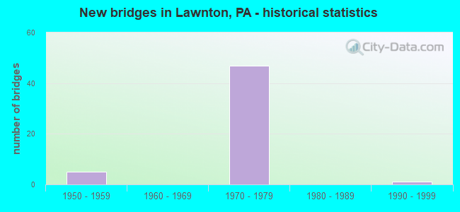
- New bridges - historical statistics
- 51950-1959
- 471970-1979
- 11990-1999

- Reconstructed bridges - Historical Statistics
- 11980-1989
- 11990-1999


- Bridge Condition - Deck
- 46.7%Good
- 53.3%Satisfactory

- Bridge Condition - Superstructure
- 6.7%Good
- 46.7%Satisfactory
- 46.7%Fair

- Bridge Condition - Substructure
- 6.7%Good
- 46.7%Satisfactory
- 46.7%Fair

- Bridge Condition - Channel
- 50.0%Very good
- 50.0%Satisfactory
Find on map >> Show street view
Structure Number: 14273, Location: EISENHOWER INTERCHANGE (Lat: 40.253281, Lng: -76.815069), Route carried "on" structure: Interstate 83, Year Built: 1970, Status: Open, Structure Length: 27.58m (90.49ft), Average Daily Traffic: 39,361 (year 2022), Truck Traffic: 14%, Average Future Daily Traffic: 46,745 (year 2032), Design Load: HS 20, Features Intersected: US322&RE;I283S;RA;SR3001
Minimum Vertical Clearance: 30+ m (98+ ft), Kilometerpoint: 6.310, Lanes on structure: 1, Lanes under structure: 9, Base Highway Network: Yes, Owner: State Highway Agency, Approaching Roadway Width: 16.8m (55.1ft), Skew: 9 degrees, Material/Design: Steel continuous, Design/Construction: Stringer/Multi-beam, Number Of Spans In Main Unit: 10, Length of Maximum Span: 42.1m (138.1ft), Curb or Sidewalk Widths: Left: 0.3m (1.0ft), Right: 0.2m (0.7ft), Curb-To-Curb Width: 6.8m (22.3ft), Out-to-Out Width: 8.1m (26.6ft)
Condition: Deck: Satisfactory, Superstructure: Fair, Substructure: Fair, Operating Rating: 39.0 metric tons, Method Used To Determine Operating Rating: Load Factor (LF), Inventory Rating: 11.8 metric tons, Method Used To Determine Inventory Rating: Load Factor (LF), Structural Evaluation: High priority of corrective action, Deck Geometry: High priority of replacement, Underclear: High priority of corrective action, Approach Roadway Alignment: Equal to present minimum criteria, Length Of Structure Improvement: 28.00m (91.86ft), Designated Inspection Frequency: Every 24 months, Inspection Date: October 2020, Bridge Improvement Cost: $443,000, Roadway Improvement Cost: $1,305,000, Total Project Cost: $5,983,000, Deck Structure Type: Concrete Cast-file-Place, Wearing Surface/Protective System: Wearing Surface: Bituminous
Find on map >> Show street view
Structure Number: 14274, Location: SWATARA TOWNSHIP 3007K10 (Lat: 40.254614, Lng: -76.810644), Route carried "on" structure: Interstate 83, Year Built: 1970, Status: Open, Structure Length: 5.49m (18.01ft), Average Daily Traffic: 39,361 (year 2022), Truck Traffic: 14%, Average Future Daily Traffic: 46,745 (year 2032), Design Load: HS 20, Features Intersected: NORFOLK SOUTHERN
Minimum Vertical Clearance: 30+ m (98+ ft), Kilometerpoint: 6.310, Lanes on structure: 2, Base Highway Network: Yes, Owner: State Highway Agency, Approaching Roadway Width: 12.5m (41.0ft), Skew: 11 degrees, Material/Design: Prestressed concrete, Design/Construction: Box Beam or Girders - Single/Spread, Number Of Spans In Main Unit: 3, Length of Maximum Span: 21.9m (71.9ft), Curb or Sidewalk Widths: Left: 0.2m (0.7ft), Right: 0.2m (0.7ft), Curb-To-Curb Width: 13.4m (44.0ft), Out-to-Out Width: 14.6m (47.9ft)
Condition: Deck: Good, Superstructure: Fair, Substructure: Satisfactory, Operating Rating: 76.2 metric tons, Method Used To Determine Operating Rating: Load Factor (LF), Inventory Rating: 45.4 metric tons, Method Used To Determine Inventory Rating: Load Factor (LF), Structural Evaluation: Somewhat better than minimum adequacy, Deck Geometry: Superior to present desirable criteria, Underclear: High priority of corrective action, Approach Roadway Alignment: Equal to present desirable criteria, Length Of Structure Improvement: 6.40m (21.00ft), Designated Inspection Frequency: Every 24 months, Inspection Date: November 2020, Bridge Improvement Cost: $71,000, Roadway Improvement Cost: $209,000, Total Project Cost: $959,000, Deck Structure Type: Concrete Cast-file-Place, Wearing Surface/Protective System: Wearing Surface: Bituminous
Find on map >> Show street view
Structure Number: 14275, Location: EISENHOWER INTERCHANGE (Lat: 40.253353, Lng: -76.812867), Route carried "on" structure: Interstate 83, Year Built: 1970, Status: Open, Structure Length: 21.34m (70.01ft), Average Daily Traffic: 39,438 (year 2022), Truck Traffic: 12%, Average Future Daily Traffic: 46,839 (year 2032), Design Load: HS 20, Features Intersected: I-83; US 322; SR 0083
Minimum Vertical Clearance: 30+ m (98+ ft), Kilometerpoint: 6.286, Lanes on structure: 1, Lanes under structure: 28, Base Highway Network: Yes, Owner: State Highway Agency, Approaching Roadway Width: 12.8m (42.0ft), Skew: 9 degrees, Material/Design: Steel, Design/Construction: Stringer/Multi-beam, Number Of Spans In Main Unit: 13, Length of Maximum Span: 31.7m (104.0ft), Curb or Sidewalk Widths: Left: 0.2m (0.7ft), Right: 0.2m (0.7ft), Curb-To-Curb Width: 6.8m (22.3ft), Out-to-Out Width: 8.1m (26.6ft)
Condition: Deck: Satisfactory, Superstructure: Satisfactory, Substructure: Fair, Operating Rating: 81.6 metric tons, Method Used To Determine Operating Rating: Load Factor (LF), Inventory Rating: 49.0 metric tons, Method Used To Determine Inventory Rating: Load Factor (LF), Structural Evaluation: Somewhat better than minimum adequacy, Deck Geometry: High priority of replacement, Underclear: Somewhat better than minimum adequacy, Approach Roadway Alignment: Equal to present minimum criteria, Length Of Structure Improvement: 21.70m (71.19ft), Designated Inspection Frequency: Every 24 months, Inspection Date: December 2020, Bridge Improvement Cost: $343,000, Roadway Improvement Cost: $1,011,000, Total Project Cost: $4,635,000, Deck Structure Type: Concrete Cast-file-Place, Wearing Surface/Protective System: Wearing Surface: Bituminous
Find on map >> Show street view
Structure Number: 14278, Location: .5 MI.E. OF LAWNTON (Lat: 40.259619, Lng: -76.813172), Route carried "on" structure: Interstate 83, Year Built: 1970, Status: Open, Structure Length: 4.27m (14.01ft), Average Daily Traffic: 78,799 (year 2022), Truck Traffic: 13%, Average Future Daily Traffic: 93,584 (year 2032), Design Load: HS 20, Features Intersected: SR 3001
Minimum Vertical Clearance: 30+ m (98+ ft), Kilometerpoint: 7.145, Lanes on structure: 2, Lanes under structure: 2, Base Highway Network: Yes, Owner: State Highway Agency, Approaching Roadway Width: 24.1m (79.1ft), Skew: 33 degrees, Material/Design: Prestressed concrete, Design/Construction: Box Beam or Girders - Single/Spread, Number Of Spans In Main Unit: 3, Length of Maximum Span: 22.3m (73.2ft), Curb or Sidewalk Widths: Left: 0.2m (0.7ft), Right: 0.2m (0.7ft), Curb-To-Curb Width: 23.5m (77.1ft), Out-to-Out Width: 25.0m (82.0ft)
Condition: Deck: Satisfactory, Superstructure: Fair, Substructure: Fair, Operating Rating: 59.0 metric tons, Method Used To Determine Operating Rating: Load Factor (LF), Inventory Rating: 29.0 metric tons, Method Used To Determine Inventory Rating: Load Factor (LF), Structural Evaluation: Somewhat better than minimum adequacy, Deck Geometry: Superior to present desirable criteria, Underclear: Equal to present minimum criteria, Approach Roadway Alignment: Meets minimum limits, Length Of Structure Improvement: 5.20m (17.06ft), Designated Inspection Frequency: Every 24 months, Inspection Date: October 2020, Bridge Improvement Cost: $97,000, Roadway Improvement Cost: $286,000, Total Project Cost: $1,311,000, Deck Structure Type: Concrete Cast-file-Place, Wearing Surface/Protective System: Wearing Surface: Bituminous
Find on map >> Show street view
Structure Number: 14279, Location: EISENHOWER INTERCHANGE (Lat: 40.254492, Lng: -76.811081), Route carried "on" structure: Interstate 83, Year Built: 1970, Status: Open, Structure Length: 5.52m (18.11ft), Average Daily Traffic: 39,438 (year 2022), Truck Traffic: 12%, Average Future Daily Traffic: 46,839 (year 2032), Design Load: HS 20, Features Intersected: NORFOLK SOUTHERN
Minimum Vertical Clearance: 30+ m (98+ ft), Kilometerpoint: 6.286, Lanes on structure: 2, Base Highway Network: Yes, Owner: State Highway Agency, Approaching Roadway Width: 11.6m (38.1ft), Skew: 12 degrees, Material/Design: Prestressed concrete, Design/Construction: Box Beam or Girders - Multiple, Number Of Spans In Main Unit: 1, Number Of Approach Spans: 2, Length of Maximum Span: 24.1m (79.1ft), Curb or Sidewalk Widths: Left: 0.2m (0.7ft), Right: 0.2m (0.7ft), Curb-To-Curb Width: 11.9m (39.0ft), Out-to-Out Width: 13.1m (43.0ft)
Condition: Deck: Good, Superstructure: Fair, Substructure: Satisfactory, Operating Rating: 59.0 metric tons, Method Used To Determine Operating Rating: Load Factor (LF), Inventory Rating: 34.5 metric tons, Method Used To Determine Inventory Rating: Load Factor (LF), Structural Evaluation: Somewhat better than minimum adequacy, Deck Geometry: Equal to present minimum criteria, Underclear: High priority of corrective action, Approach Roadway Alignment: Equal to present desirable criteria, Length Of Structure Improvement: 6.50m (21.33ft), Designated Inspection Frequency: Every 24 months, Inspection Date: November 2020, Bridge Improvement Cost: $28,000, Roadway Improvement Cost: $83,000, Total Project Cost: $380,000, Deck Structure Type: Concrete Cast-file-Place, Wearing Surface/Protective System: Wearing Surface: Bituminous
Find on map >> Show street view
Structure Number: 1428, Location: 0.7 MI N OF EXIT-28;I-83 (Lat: 40.267256, Lng: -76.814664), Route carried "on" structure: Interstate 83, Year Built: 1953, Year Reconstructed: 1994, Status: Open, Structure Length: 1.10m (3.61ft), Average Daily Traffic: 124,398 (year 2022), Truck Traffic: 10%, Average Future Daily Traffic: 147,737 (year 2032), Design Load: HS 20, Features Intersected: TWP RD 369 & SPRNG CRK.R
Minimum Vertical Clearance: 30+ m (98+ ft), Kilometerpoint: 7.974, Lanes on structure: 6, Lanes under structure: 2, Base Highway Network: Yes, Owner: State Highway Agency, Approaching Roadway Width: 30.5m (100.1ft), Skew: 31 degrees, Material/Design: Concrete, Design/Construction: Culvert, Number Of Spans In Main Unit: 2, Length of Maximum Span: 11.0m (36.1ft)
Condition: Channel: Very good, Culverts: Satisfactory, Operating Rating: 70.8 metric tons, Method Used To Determine Operating Rating: Field evaluation and documented engineering judgment, Inventory Rating: 42.6 metric tons, Method Used To Determine Inventory Rating: Field evaluation and documented engineering judgment, Structural Evaluation: Equal to present minimum criteria, Underclear: Better than present minimum criteria, Waterway Adequacy: Equal to present desirable criteria, Approach Roadway Alignment: Equal to present desirable criteria, Length Of Structure Improvement: 3.00m (9.84ft), Designated Inspection Frequency: Every 24 months, Inspection Date: October 2020
Find on map >> Show street view
Structure Number: 14343, Location: EISENHOWER (Lat: 40.253578, Lng: -76.811086), Route carried "on" structure: Interstate 283, Year Built: 1970, Status: Open, Structure Length: 7.71m (25.30ft), Average Daily Traffic: 33,776 (year 2021), Truck Traffic: 18%, Average Future Daily Traffic: 45,461 (year 2032), Design Load: HS 20, Features Intersected: SR 0322 WB; RAMP K
Minimum Vertical Clearance: 30+ m (98+ ft), Kilometerpoint: 3.848, Lanes on structure: 1, Lanes under structure: 8, Base Highway Network: Yes, Owner: State Highway Agency, Approaching Roadway Width: 7.3m (24.0ft), Skew: 9 degrees, Material/Design: Prestressed concrete, Design/Construction: Box Beam or Girders - Single/Spread, Number Of Spans In Main Unit: 5, Length of Maximum Span: 24.4m (80.1ft), Curb or Sidewalk Widths: Left: 0.2m (0.7ft), Right: 0.2m (0.7ft), Curb-To-Curb Width: 6.9m (22.6ft), Out-to-Out Width: 8.1m (26.6ft)
Condition: Deck: Satisfactory, Superstructure: Fair, Substructure: Fair, Operating Rating: 62.6 metric tons, Method Used To Determine Operating Rating: Load Factor (LF), Inventory Rating: 31.8 metric tons, Method Used To Determine Inventory Rating: Load Factor (LF), Structural Evaluation: Somewhat better than minimum adequacy, Deck Geometry: High priority of replacement, Underclear: High priority of corrective action, Approach Roadway Alignment: Better than present minimum criteria, Length Of Structure Improvement: 8.70m (28.54ft), Designated Inspection Frequency: Every 24 months, Inspection Date: November 2020, Bridge Improvement Cost: $49,000, Roadway Improvement Cost: $145,000, Total Project Cost: $665,000, Deck Structure Type: Concrete Cast-file-Place, Wearing Surface/Protective System: Wearing Surface: Latex Concrete
Find on map >> Show street view
Structure Number: 14344, Location: EISENHOWER (Lat: 40.252817, Lng: -76.812658), Route carried "on" structure: Interstate 283, Year Built: 1970, Status: Open, Structure Length: 3.84m (12.60ft), Average Daily Traffic: 31,880 (year 2021), Truck Traffic: 19%, Average Future Daily Traffic: 44,204 (year 2032), Design Load: HS 20, Features Intersected: SR 8027, RAMP A
Minimum Vertical Clearance: 30+ m (98+ ft), Kilometerpoint: 3.848, Lanes on structure: 1, Lanes under structure: 1, Base Highway Network: Yes, Owner: State Highway Agency, Approaching Roadway Width: 9.1m (29.9ft), Skew: 3 degrees, Material/Design: Prestressed concrete, Design/Construction: Box Beam or Girders - Single/Spread, Number Of Spans In Main Unit: 3, Length of Maximum Span: 17.1m (56.1ft), Curb or Sidewalk Widths: Left: 0.2m (0.7ft), Right: 0.2m (0.7ft), Curb-To-Curb Width: 8.9m (29.2ft), Out-to-Out Width: 10.1m (33.1ft)
Condition: Deck: Satisfactory, Superstructure: Fair, Substructure: Fair, Operating Rating: 49.0 metric tons, Method Used To Determine Operating Rating: Load Factor (LF), Inventory Rating: 29.0 metric tons, Method Used To Determine Inventory Rating: Load Factor (LF), Structural Evaluation: Somewhat better than minimum adequacy, Deck Geometry: High priority of replacement, Underclear: Somewhat better than minimum adequacy, Approach Roadway Alignment: Equal to present desirable criteria, Length Of Structure Improvement: 4.70m (15.42ft), Designated Inspection Frequency: Every 24 months, Inspection Date: November 2020, Bridge Improvement Cost: $36,000, Roadway Improvement Cost: $106,000, Total Project Cost: $486,000, Deck Structure Type: Concrete Cast-file-Place, Wearing Surface/Protective System: Wearing Surface: Latex Concrete
Find on map >> Show street view
Structure Number: 14345, Location: EISENHOWER INTERCHANGE (Lat: 40.254089, Lng: -76.811417), Route carried "on" structure: Interstate 283, Year Built: 1970, Status: Open, Structure Length: 6.46m (21.19ft), Average Daily Traffic: 31,880 (year 2021), Truck Traffic: 19%, Average Future Daily Traffic: 44,204 (year 2032), Design Load: HS 20, Features Intersected: US 322WB, SR 8030 RAMP E
Minimum Vertical Clearance: 5.13m (16.83ft), Kilometerpoint: 3.848, Lanes on structure: 1, Lanes under structure: 6, Base Highway Network: Yes, Owner: State Highway Agency, Approaching Roadway Width: 12.8m (42.0ft), Skew: 9 degrees, Material/Design: Steel, Design/Construction: Stringer/Multi-beam, Number Of Spans In Main Unit: 3, Number Of Approach Spans: 1, Length of Maximum Span: 18.6m (61.0ft), Curb or Sidewalk Widths: Left: 0.2m (0.7ft), Right: 0.2m (0.7ft), Curb-To-Curb Width: 6.9m (22.6ft), Out-to-Out Width: 8.1m (26.6ft)
Condition: Deck: Good, Superstructure: Satisfactory, Substructure: Fair, Operating Rating: 84.4 metric tons, Method Used To Determine Operating Rating: Load Factor (LF), Inventory Rating: 49.9 metric tons, Method Used To Determine Inventory Rating: Load Factor (LF), Structural Evaluation: Somewhat better than minimum adequacy, Deck Geometry: High priority of replacement, Underclear: Somewhat better than minimum adequacy, Approach Roadway Alignment: Equal to present desirable criteria, Length Of Structure Improvement: 7.40m (24.28ft), Designated Inspection Frequency: Every 24 months, Inspection Date: November 2020, Bridge Improvement Cost: $12,000, Roadway Improvement Cost: $34,000, Total Project Cost: $156,000, Deck Structure Type: Concrete Cast-file-Place, Wearing Surface/Protective System: Wearing Surface: Bituminous
Find on map >> Show street view
Structure Number: 14367, Location: EISENHOWER INTERCHANGE (Lat: 40.253031, Lng: -76.813364), Route carried "on" structure: US 322, Year Built: 1970, Status: Open, Structure Length: 25.09m (82.32ft), Average Daily Traffic: 18,725 (year 2020), Truck Traffic: 12%, Average Future Daily Traffic: 27,028 (year 2032), Design Load: HS 20, Features Intersected: SR 3001, I-283, RP.A&K
Minimum Vertical Clearance: 7.01m (23.00ft), Kilometerpoint: 0.000, Lanes on structure: 3, Lanes under structure: 42, Base Highway Network: Yes, Owner: State Highway Agency, Approaching Roadway Width: 16.8m (55.1ft), Material/Design: Steel continuous, Design/Construction: Stringer/Multi-beam, Number Of Spans In Main Unit: 9, Length of Maximum Span: 32.6m (107.0ft), Curb or Sidewalk Widths: Left: 0.2m (0.7ft), Right: 0.2m (0.7ft), Curb-To-Curb Width: 15.4m (50.5ft), Out-to-Out Width: 16.6m (54.5ft)
Condition: Deck: Satisfactory, Superstructure: Fair, Substructure: Satisfactory, Operating Rating: 60.8 metric tons, Method Used To Determine Operating Rating: Load Factor (LF), Inventory Rating: 36.3 metric tons, Method Used To Determine Inventory Rating: Load Factor (LF), Structural Evaluation: Somewhat better than minimum adequacy, Deck Geometry: Equal to present minimum criteria, Underclear: High priority of corrective action, Approach Roadway Alignment: Equal to present desirable criteria, Length Of Structure Improvement: 25.60m (83.99ft), Designated Inspection Frequency: Every 24 months, Inspection Date: October 2020, Bridge Improvement Cost: $621,000, Roadway Improvement Cost: $1,830,000, Total Project Cost: $8,387,000, Deck Structure Type: Concrete Cast-file-Place, Wearing Surface/Protective System: Wearing Surface: Latex Concrete
Find on map >> Show street view
Structure Number: 14368, Location: EISENHOWER (Lat: 40.253578, Lng: -76.813969), Route carried "on" structure: US 322, Year Built: 1970, Status: Open, Structure Length: 4.36m (14.30ft), Average Daily Traffic: 18,454 (year 2020), Truck Traffic: 13%, Average Future Daily Traffic: 19,278 (year 2032), Design Load: HS 20, Features Intersected: SR 3001; (US 322 EB)
Minimum Vertical Clearance: 30+ m (98+ ft), Kilometerpoint: 0.000, Lanes on structure: 3, Lanes under structure: 8, Base Highway Network: Yes, Owner: State Highway Agency, Approaching Roadway Width: 15.2m (49.9ft), Material/Design: Prestressed concrete, Design/Construction: Box Beam or Girders - Single/Spread, Number Of Spans In Main Unit: 3, Length of Maximum Span: 24.1m (79.1ft), Curb or Sidewalk Widths: Left: 0.2m (0.7ft), Right: 0.2m (0.7ft), Curb-To-Curb Width: 15.6m (51.2ft), Out-to-Out Width: 16.8m (55.1ft)
Condition: Deck: Satisfactory, Superstructure: Satisfactory, Substructure: Fair, Operating Rating: 56.2 metric tons, Method Used To Determine Operating Rating: Load Factor (LF), Inventory Rating: 33.6 metric tons, Method Used To Determine Inventory Rating: Load Factor (LF), Structural Evaluation: Somewhat better than minimum adequacy, Deck Geometry: Equal to present minimum criteria, Underclear: Meets minimum limits, Approach Roadway Alignment: Equal to present desirable criteria, Length Of Structure Improvement: 5.30m (17.39ft), Designated Inspection Frequency: Every 24 months, Inspection Date: November 2020, Deck Structure Type: Concrete Cast-file-Place, Wearing Surface/Protective System: Wearing Surface: Latex Concrete
Find on map >> Show street view
Structure Number: 14369, Location: CHAMBERS HILL (Lat: 40.253094, Lng: -76.803350), Route carried "on" structure: US 322, Year Built: 1970, Year Reconstructed: 1999, Status: Open, Structure Length: 5.70m (18.70ft), Average Daily Traffic: 18,725 (year 2020), Truck Traffic: 12%, Average Future Daily Traffic: 28,378 (year 2032), Design Load: HS 20, Features Intersected: SR 3030 & ABANDONED RR
Minimum Vertical Clearance: 30+ m (98+ ft), Kilometerpoint: 1.180, Lanes on structure: 3, Lanes under structure: 6, Base Highway Network: Yes, Owner: State Highway Agency, Approaching Roadway Width: 16.2m (53.1ft), Skew: 10 degrees, Material/Design: Prestressed concrete, Design/Construction: Box Beam or Girders - Single/Spread, Number Of Spans In Main Unit: 3, Length of Maximum Span: 27.7m (90.9ft), Curb or Sidewalk Widths: Left: 0.2m (0.7ft), Right: 0.2m (0.7ft), Curb-To-Curb Width: 14.2m (46.6ft), Out-to-Out Width: 15.4m (50.5ft)
Condition: Deck: Good, Superstructure: Satisfactory, Substructure: Satisfactory, Operating Rating: 64.4 metric tons, Method Used To Determine Operating Rating: Load Factor (LF), Inventory Rating: 33.6 metric tons, Method Used To Determine Inventory Rating: Load Factor (LF), Structural Evaluation: Equal to present minimum criteria, Deck Geometry: Somewhat better than minimum adequacy, Underclear: Equal to present minimum criteria, Approach Roadway Alignment: Equal to present desirable criteria, Length Of Structure Improvement: 6.70m (21.98ft), Designated Inspection Frequency: Every 24 months, Inspection Date: August 2020, Deck Structure Type: Concrete Cast-file-Place, Wearing Surface/Protective System: Wearing Surface: Latex Concrete
Find on map >> Show street view
Structure Number: 14535, Location: DERRY ST. LAWNTON (Lat: 40.257694, Lng: -76.814019), Route carried "on" structure: State highway , Year Built: 1953, Status: Open, Structure Length: 2.32m (7.61ft), Average Daily Traffic: 11,860 (year 2020), Truck Traffic: 3%, Average Future Daily Traffic: 23,617 (year 2032), Design Load: HS 20, Features Intersected: US 322; SR 3001, Facility Carried by Structure: SR 3012
Minimum Vertical Clearance: 30+ m (98+ ft), Kilometerpoint: 6.566, Lanes on structure: 2, Lanes under structure: 8, Owner: State Highway Agency, Approaching Roadway Width: 12.2m (40.0ft), Material/Design: Concrete, Design/Construction: Frame, Number Of Spans In Main Unit: 1, Length of Maximum Span: 21.9m (71.9ft), Curb or Sidewalk Widths: Left: 1.5m (4.9ft), Right: 1.5m (4.9ft), Curb-To-Curb Width: 12.2m (40.0ft), Out-to-Out Width: 16.2m (53.1ft)
Condition: Deck: Satisfactory, Superstructure: Satisfactory, Substructure: Good, Operating Rating: 49.0 metric tons, Method Used To Determine Operating Rating: Field evaluation and documented engineering judgment, Inventory Rating: 32.7 metric tons, Method Used To Determine Inventory Rating: Field evaluation and documented engineering judgment, Structural Evaluation: Equal to present minimum criteria, Deck Geometry: Somewhat better than minimum adequacy, Underclear: Equal to present minimum criteria, Approach Roadway Alignment: Equal to present desirable criteria, Length Of Structure Improvement: 3.00m (9.84ft), Designated Inspection Frequency: Every 24 months, Inspection Date: December 2020, Bridge Improvement Cost: $31,000, Roadway Improvement Cost: $92,000, Total Project Cost: $420,000, Deck Structure Type: Concrete Cast-file-Place, Wearing Surface/Protective System: Wearing Surface: Bituminous
Find on map >> Show street view
Structure Number: 14679, Location: .1E I-83&1S PT./SPR CK (Lat: 40.268042, Lng: -76.813500), Route carried "on" structure: City street , Year Built: 1996, Status: Open, Structure Length: 0.79m (2.59ft), Average Daily Traffic: 200 (year 2021), Truck Traffic: 7%, Average Future Daily Traffic: 350 (year 2041), Design Load: HS 25 or greater, Features Intersected: SPRING CR-, Facility Carried by Structure: PEIFFERS LN. T-392
Minimum Vertical Clearance: 30+ m (98+ ft), Kilometerpoint: 0.000, Lanes on structure: 2, Owner: Town or Township Highway Agency, Approaching Roadway Width: 8.5m (27.9ft), Skew: 3 degrees, Material/Design: Prestressed concrete, Design/Construction: Box Beam or Girders - Single/Spread, Number Of Spans In Main Unit: 1, Length of Maximum Span: 7.6m (24.9ft), Curb or Sidewalk Widths: Left: 0.2m (0.7ft), Right: 0.2m (0.7ft), Curb-To-Curb Width: 8.5m (27.9ft), Out-to-Out Width: 9.6m (31.5ft)
Condition: Deck: Good, Superstructure: Good, Substructure: Satisfactory, Channel: Satisfactory, Operating Rating: 68.0 metric tons, Method Used To Determine Operating Rating: Load Factor (LF), Inventory Rating: 40.8 metric tons, Method Used To Determine Inventory Rating: Load Factor (LF), Structural Evaluation: Equal to present minimum criteria, Deck Geometry: Equal to present minimum criteria, Waterway Adequacy: Better than present minimum criteria, Approach Roadway Alignment: Equal to present minimum criteria, Length Of Structure Improvement: 1.40m (4.59ft), Designated Inspection Frequency: Every 24 months, Inspection Date: May 2021, Roadway Improvement Cost: $56,000, Total Project Cost: $258,000, Deck Structure Type: Concrete Cast-file-Place, Wearing Surface/Protective System: Wearing Surface: Monolithic Concrete, Deck Protection: Epoxy Coated Reinforcing
Find on map >> Show street view
Structure Number: 14771, Location: 2 MI. E. OF HBG. (Lat: 40.254944, Lng: -76.799028), Route carried "on" structure: Ramp State highway , Year Built: 1970, Status: Open, Structure Length: 2.62m (8.60ft), Average Daily Traffic: 4,908 (year 2022), Truck Traffic: 7%, Average Future Daily Traffic: 6,308 (year 2032), Design Load: HS 20, Features Intersected: PAXTON STREET, Facility Carried by Structure: SR 8010;RP E-3,E-4
Minimum Vertical Clearance: 30+ m (98+ ft), Kilometerpoint: 0.000, Lanes on structure: 2, Lanes under structure: 4, Base Highway Network: Yes, Owner: State Highway Agency, Approaching Roadway Width: 17.4m (57.1ft), Skew: 30 degrees, Material/Design: Steel, Design/Construction: Stringer/Multi-beam, Number Of Spans In Main Unit: 1, Length of Maximum Span: 25.0m (82.0ft), Curb or Sidewalk Widths: Left: 0.2m (0.7ft), Right: 0.2m (0.7ft), Curb-To-Curb Width: 17.1m (56.1ft), Out-to-Out Width: 20.2m (66.3ft)
Condition: Deck: Good, Superstructure: Satisfactory, Substructure: Satisfactory, Operating Rating: 68.9 metric tons, Method Used To Determine Operating Rating: Load Factor (LF), Inventory Rating: 41.7 metric tons, Method Used To Determine Inventory Rating: Load Factor (LF), Structural Evaluation: Equal to present minimum criteria, Deck Geometry: Superior to present desirable criteria, Underclear: Meets minimum limits, Approach Roadway Alignment: Equal to present desirable criteria, Length Of Structure Improvement: 3.40m (11.15ft), Designated Inspection Frequency: Every 24 months, Inspection Date: November 2020, Bridge Improvement Cost: $46,000, Roadway Improvement Cost: $136,000, Total Project Cost: $624,000, Deck Structure Type: Concrete Cast-file-Place, Wearing Surface/Protective System: Wearing Surface: Latex Concrete
Find on map >> Show street view
Structure Number: 14781, Location: EISENHOWER INTERCHANGE (Lat: 40.253306, Lng: -76.813944), Route carried "on" structure: Ramp State highway , Year Built: 1970, Status: Open, Structure Length: 4.48m (14.70ft), Average Daily Traffic: 11,785 (year 2021), Truck Traffic: 7%, Average Future Daily Traffic: 19,686 (year 2032), Design Load: HS 20, Features Intersected: SR 3001; EISENHOWER BLVD, Facility Carried by Structure: SR 8027; RAMP A
Minimum Vertical Clearance: 30+ m (98+ ft), Kilometerpoint: 0.000, Lanes on structure: 1, Lanes under structure: 8, Base Highway Network: Yes, Owner: State Highway Agency, Approaching Roadway Width: 9.8m (32.2ft), Skew: 1 degrees, Material/Design: Prestressed concrete, Design/Construction: Box Beam or Girders - Single/Spread, Number Of Spans In Main Unit: 3, Length of Maximum Span: 24.1m (79.1ft), Curb or Sidewalk Widths: Left: 0.2m (0.7ft), Right: 0.2m (0.7ft), Curb-To-Curb Width: 8.9m (29.2ft), Out-to-Out Width: 10.1m (33.1ft)
Condition: Deck: Good, Superstructure: Satisfactory, Substructure: Satisfactory, Operating Rating: 59.0 metric tons, Method Used To Determine Operating Rating: Load Factor (LF), Inventory Rating: 32.7 metric tons, Method Used To Determine Inventory Rating: Load Factor (LF), Structural Evaluation: Equal to present minimum criteria, Deck Geometry: Superior to present desirable criteria, Underclear: Equal to present minimum criteria, Approach Roadway Alignment: Equal to present desirable criteria, Length Of Structure Improvement: 5.40m (17.72ft), Designated Inspection Frequency: Every 24 months, Inspection Date: November 2020, Deck Structure Type: Concrete Cast-file-Place, Wearing Surface/Protective System: Wearing Surface: Latex Concrete
Find on map >> Show street view
Structure Number: 14273, Location: EISENHOWER INTERCHANGE (Lat: 40.253281, Lng: -76.815069), Route carried "under" structure: Interstate 283, Year Built: 1970, Structure Length: 0. m, Average Daily Traffic: 31,880 (year 2021), Truck Traffic: 19%, Features Intersected: US322&RE;I283S;RA;SR3001, Facility Carried by Structure: I-83 NB; SR 0083
Minimum Vertical Clearance: 5.13m (16.83ft), Kilometerpoint: 3.848, Lanes on structure: 1, Lanes under structure: 1, Material/Design: Steel continuous, Design/Construction: Stringer/Multi-beam, Length of Maximum Span: 42.1m (138.1ft)
Find on map >> Show street view
Structure Number: 14273, Location: EISENHOWER INTERCHANGE (Lat: 40.253281, Lng: -76.815069), Route carried "under" structure: US 322, Year Built: 1970, Structure Length: 0. m, Average Daily Traffic: 18,454 (year 2020), Truck Traffic: 13%, Features Intersected: US322&RE;I283S;RA;SR3001, Facility Carried by Structure: I-83 NB; SR 0083
Minimum Vertical Clearance: 11.73m (38.48ft), Kilometerpoint: 0.402, Lanes on structure: 1, Lanes under structure: 3, Material/Design: Steel continuous, Design/Construction: Stringer/Multi-beam, Length of Maximum Span: 42.1m (138.1ft)
Find on map >> Show street view
Structure Number: 14273, Location: EISENHOWER INTERCHANGE (Lat: 40.253281, Lng: -76.815069), Route carried "under" structure: Ramp State highway , Year Built: 1970, Structure Length: 0. m, Average Daily Traffic: 11,785 (year 2021), Truck Traffic: 7%, Features Intersected: US322&RE;I283S;RA;SR3001, Facility Carried by Structure: I-83 NB; SR 0083
Minimum Vertical Clearance: 6.25m (20.51ft), Kilometerpoint: 0.000, Lanes on structure: 1, Lanes under structure: 1, Material/Design: Steel continuous, Design/Construction: Stringer/Multi-beam, Length of Maximum Span: 42.1m (138.1ft)
Find on map >> Show street view
Structure Number: 14273, Location: EISENHOWER INTERCHANGE (Lat: 40.253281, Lng: -76.815069), Route carried "under" structure: State highway , Year Built: 1970, Structure Length: 0. m, Average Daily Traffic: 10,976 (year 2022), Truck Traffic: 5%, Features Intersected: US322&RE;I283S;RA;SR3001, Facility Carried by Structure: I-83 NB; SR 0083
Minimum Vertical Clearance: 11.61m (38.09ft), Kilometerpoint: 4.609, Lanes on structure: 1, Lanes under structure: 2, Material/Design: Steel continuous, Design/Construction: Stringer/Multi-beam, Length of Maximum Span: 42.1m (138.1ft)
Find on map >> Show street view
Structure Number: 14273, Location: EISENHOWER INTERCHANGE (Lat: 40.253281, Lng: -76.815069), Route carried "under" structure: State highway , Year Built: 1970, Structure Length: 0. m, Average Daily Traffic: 9,176 (year 2022), Truck Traffic: 7%, Features Intersected: US322&RE;I283S;RA;SR3001, Facility Carried by Structure: I-83 NB; SR 0083
Minimum Vertical Clearance: 11.78m (38.65ft), Kilometerpoint: 4.609, Lanes on structure: 1, Lanes under structure: 2, Material/Design: Steel continuous, Design/Construction: Stringer/Multi-beam, Length of Maximum Span: 42.1m (138.1ft)
Find on map >> Show street view
Structure Number: 14275, Location: EISENHOWER INTERCHANGE (Lat: 40.253353, Lng: -76.812867), Route carried "under" structure: US 322, Year Built: 1970, Structure Length: 0. m, Average Daily Traffic: 18,454 (year 2020), Truck Traffic: 13%, Features Intersected: I-83; US 322; SR 0083, Facility Carried by Structure: I-83 SB; SR 0083
Minimum Vertical Clearance: 6.60m (21.65ft), Kilometerpoint: 0.000, Lanes on structure: 1, Lanes under structure: 7, Material/Design: Steel, Design/Construction: Stringer/Multi-beam, Length of Maximum Span: 31.7m (104.0ft)
Find on map >> Show street view
Structure Number: 14275, Location: EISENHOWER INTERCHANGE (Lat: 40.253353, Lng: -76.812867), Route carried "under" structure: State highway , Year Built: 1970, Structure Length: 0. m, Average Daily Traffic: 9,176 (year 2022), Truck Traffic: 7%, Features Intersected: I-83; US 322; SR 0083, Facility Carried by Structure: I-83 SB; SR 0083
Minimum Vertical Clearance: 5.91m (19.39ft), Kilometerpoint: 4.609, Lanes on structure: 1, Lanes under structure: 7, Material/Design: Steel, Design/Construction: Stringer/Multi-beam, Length of Maximum Span: 31.7m (104.0ft)
Find on map >> Show street view
Structure Number: 14275, Location: EISENHOWER INTERCHANGE (Lat: 40.253353, Lng: -76.812867), Route carried "under" structure: Ramp State highway , Year Built: 1970, Structure Length: 0. m, Average Daily Traffic: 7,028 (year 2022), Truck Traffic: 7%, Features Intersected: I-83; US 322; SR 0083, Facility Carried by Structure: I-83 SB; SR 0083
Minimum Vertical Clearance: 4.81m (15.78ft), Kilometerpoint: 0.000, Lanes on structure: 1, Lanes under structure: 7, Material/Design: Steel, Design/Construction: Stringer/Multi-beam, Length of Maximum Span: 31.7m (104.0ft)
Find on map >> Show street view
Structure Number: 14275, Location: EISENHOWER INTERCHANGE (Lat: 40.253353, Lng: -76.812867), Route carried "under" structure: State highway , Year Built: 1970, Structure Length: 0. m, Average Daily Traffic: 10,976 (year 2022), Truck Traffic: 5%, Features Intersected: I-83; US 322; SR 0083, Facility Carried by Structure: I-83 SB; SR 0083
Minimum Vertical Clearance: 5.85m (19.19ft), Kilometerpoint: 4.609, Lanes on structure: 1, Lanes under structure: 7, Material/Design: Steel, Design/Construction: Stringer/Multi-beam, Length of Maximum Span: 31.7m (104.0ft)
Find on map >> Show street view
Structure Number: 14276, Location: .5 MI.E. OF LAWNTON (Lat: 40.257919, Lng: -76.810903), Route carried "under" structure: State highway , Year Built: 1970, Structure Length: 0. m, Average Daily Traffic: 11,860 (year 2020), Truck Traffic: 3%, Features Intersected: SR 3012, Facility Carried by Structure: I-83; SR 0083
Minimum Vertical Clearance: 4.54m (14.90ft), Kilometerpoint: 7.144, Lanes on structure: 4, Lanes under structure: 4, Material/Design: Prestressed concrete, Design/Construction: Box Beam or Girders - Single/Spread, Length of Maximum Span: 23.2m (76.1ft)
Find on map >> Show street view
Structure Number: 14278, Location: .5 MI.E. OF LAWNTON (Lat: 40.259619, Lng: -76.813172), Route carried "under" structure: US 322, Year Built: 1970, Structure Length: 0. m, Average Daily Traffic: 9,951 (year 2020), Truck Traffic: 11%, Features Intersected: SR 3001, Facility Carried by Structure: I-83; SR 0083
Minimum Vertical Clearance: 4.48m (14.70ft), Kilometerpoint: 4.974, Lanes on structure: 2, Lanes under structure: 2, Material/Design: Prestressed concrete, Design/Construction: Box Beam or Girders - Single/Spread, Length of Maximum Span: 22.3m (73.2ft)
Find on map >> Show street view
Structure Number: 1428, Location: 0.7 MI N OF EXIT-28;I-83 (Lat: 40.267256, Lng: -76.814664), Route carried "under" structure: City street , Year Built: 1953, Structure Length: 0. m, Average Daily Traffic: 1 (year 2004), Features Intersected: TWP RD 369 & SPRNG CRK.R, Facility Carried by Structure: I-83; SR 0083
Minimum Vertical Clearance: 4.98m (16.34ft), Kilometerpoint: 0.000, Lanes on structure: 6, Lanes under structure: 2, Material/Design: Concrete, Design/Construction: Culvert, Length of Maximum Span: 11.0m (36.1ft)
Find on map >> Show street view
Structure Number: 14343, Location: EISENHOWER (Lat: 40.253578, Lng: -76.811086), Route carried "under" structure: Ramp State highway , Year Built: 1970, Structure Length: 0. m, Average Daily Traffic: 3,788 (year 2021), Truck Traffic: 7%, Features Intersected: SR 0322 WB; RAMP K, Facility Carried by Structure: I-283 NB; SR 0283
Minimum Vertical Clearance: 4.34m (14.24ft), Kilometerpoint: 0.000, Lanes on structure: 1, Lanes under structure: 4, Material/Design: Prestressed concrete, Design/Construction: Box Beam or Girders - Single/Spread, Length of Maximum Span: 24.4m (80.1ft)
Find on map >> Show street view
Structure Number: 14343, Location: EISENHOWER (Lat: 40.253578, Lng: -76.811086), Route carried "under" structure: US 322, Year Built: 1970, Structure Length: 0. m, Average Daily Traffic: 18,454 (year 2020), Truck Traffic: 13%, Features Intersected: SR 0322 WB; RAMP K, Facility Carried by Structure: I-283 NB; SR 0283
Minimum Vertical Clearance: 6.14m (20.14ft), Kilometerpoint: 0.402, Lanes on structure: 1, Lanes under structure: 4, Material/Design: Prestressed concrete, Design/Construction: Box Beam or Girders - Single/Spread, Length of Maximum Span: 24.4m (80.1ft)
Find on map >> Show street view
Structure Number: 14344, Location: EISENHOWER (Lat: 40.252817, Lng: -76.812658), Route carried "under" structure: Ramp State highway , Year Built: 1970, Structure Length: 0. m, Average Daily Traffic: 11,785 (year 2021), Truck Traffic: 7%, Features Intersected: SR 8027, RAMP A, Facility Carried by Structure: I-283 SB; SR 0283
Minimum Vertical Clearance: 5.00m (16.40ft), Kilometerpoint: 0.000, Lanes on structure: 1, Lanes under structure: 1, Material/Design: Prestressed concrete, Design/Construction: Box Beam or Girders - Single/Spread, Length of Maximum Span: 17.1m (56.1ft)
Find on map >> Show street view
Structure Number: 14345, Location: EISENHOWER INTERCHANGE (Lat: 40.254089, Lng: -76.811417), Route carried "under" structure: US 322, Year Built: 1970, Structure Length: 0. m, Average Daily Traffic: 18,454 (year 2020), Truck Traffic: 13%, Features Intersected: US 322WB, SR 8030 RAMP E, Facility Carried by Structure: I-283 SB; SR 0283
Minimum Vertical Clearance: 5.89m (19.32ft), Kilometerpoint: 0.000, Lanes on structure: 1, Lanes under structure: 3, Material/Design: Steel, Design/Construction: Stringer/Multi-beam, Length of Maximum Span: 18.6m (61.0ft)
Find on map >> Show street view
Structure Number: 14345, Location: EISENHOWER INTERCHANGE (Lat: 40.254089, Lng: -76.811417), Route carried "under" structure: Ramp State highway , Year Built: 1970, Structure Length: 0. m, Average Daily Traffic: 7,028 (year 2022), Truck Traffic: 7%, Features Intersected: US 322WB, SR 8030 RAMP E, Facility Carried by Structure: I-283 SB; SR 0283
Minimum Vertical Clearance: 6.86m (22.51ft), Kilometerpoint: 0.000, Lanes on structure: 1, Lanes under structure: 3, Material/Design: Steel, Design/Construction: Stringer/Multi-beam, Length of Maximum Span: 18.6m (61.0ft)
Find on map >> Show street view
Structure Number: 14367, Location: EISENHOWER INTERCHANGE (Lat: 40.253031, Lng: -76.813364), Route carried "under" structure: Interstate 283, Year Built: 1970, Structure Length: 0. m, Average Daily Traffic: 31,880 (year 2021), Truck Traffic: 19%, Features Intersected: SR 3001, I-283, RP.A&K, Facility Carried by Structure: US 322; SR 0322
Minimum Vertical Clearance: 5.33m (17.49ft), Kilometerpoint: 3.848, Lanes on structure: 3, Lanes under structure: 7, Material/Design: Steel continuous, Design/Construction: Stringer/Multi-beam, Length of Maximum Span: 32.6m (107.0ft)
Find on map >> Show street view
Structure Number: 14367, Location: EISENHOWER INTERCHANGE (Lat: 40.253031, Lng: -76.813364), Route carried "under" structure: Ramp State highway , Year Built: 1970, Structure Length: 0. m, Average Daily Traffic: 9,176 (year 2022), Truck Traffic: 7%, Features Intersected: SR 3001, I-283, RP.A&K, Facility Carried by Structure: US 322; SR 0322
Minimum Vertical Clearance: 11.81m (38.75ft), Kilometerpoint: 4.609, Lanes on structure: 3, Lanes under structure: 7, Material/Design: Steel continuous, Design/Construction: Stringer/Multi-beam, Length of Maximum Span: 32.6m (107.0ft)
Find on map >> Show street view
Structure Number: 14367, Location: EISENHOWER INTERCHANGE (Lat: 40.253031, Lng: -76.813364), Route carried "under" structure: Ramp State highway , Year Built: 1970, Structure Length: 0. m, Average Daily Traffic: 10,976 (year 2022), Truck Traffic: 5%, Features Intersected: SR 3001, I-283, RP.A&K, Facility Carried by Structure: US 322; SR 0322
Minimum Vertical Clearance: 11.61m (38.09ft), Kilometerpoint: 4.609, Lanes on structure: 3, Lanes under structure: 7, Material/Design: Steel continuous, Design/Construction: Stringer/Multi-beam, Length of Maximum Span: 32.6m (107.0ft)
Find on map >> Show street view
Structure Number: 14367, Location: EISENHOWER INTERCHANGE (Lat: 40.253031, Lng: -76.813364), Route carried "under" structure: Ramp State highway , Year Built: 1970, Structure Length: 0. m, Average Daily Traffic: 11,785 (year 2021), Truck Traffic: 7%, Features Intersected: SR 3001, I-283, RP.A&K, Facility Carried by Structure: US 322; SR 0322
Minimum Vertical Clearance: 6.25m (20.51ft), Kilometerpoint: 0.000, Lanes on structure: 3, Lanes under structure: 7, Material/Design: Steel continuous, Design/Construction: Stringer/Multi-beam, Length of Maximum Span: 32.6m (107.0ft)
Find on map >> Show street view
Structure Number: 14367, Location: EISENHOWER INTERCHANGE (Lat: 40.253031, Lng: -76.813364), Route carried "under" structure: Ramp State highway , Year Built: 1970, Structure Length: 0. m, Average Daily Traffic: 3,788 (year 2021), Truck Traffic: 7%, Features Intersected: SR 3001, I-283, RP.A&K, Facility Carried by Structure: US 322; SR 0322
Minimum Vertical Clearance: 6.68m (21.92ft), Kilometerpoint: 0.000, Lanes on structure: 3, Lanes under structure: 7, Material/Design: Steel continuous, Design/Construction: Stringer/Multi-beam, Length of Maximum Span: 32.6m (107.0ft)
Find on map >> Show street view
Structure Number: 14367, Location: EISENHOWER INTERCHANGE (Lat: 40.253031, Lng: -76.813364), Route carried "under" structure: Interstate 283, Year Built: 1970, Structure Length: 0. m, Average Daily Traffic: 33,776 (year 2021), Truck Traffic: 18%, Features Intersected: SR 3001, I-283, RP.A&K, Facility Carried by Structure: US 322; SR 0322
Minimum Vertical Clearance: 5.72m (18.77ft), Kilometerpoint: 3.848, Lanes on structure: 3, Lanes under structure: 7, Material/Design: Steel continuous, Design/Construction: Stringer/Multi-beam, Length of Maximum Span: 32.6m (107.0ft)
Find on map >> Show street view
Structure Number: 14368, Location: EISENHOWER (Lat: 40.253578, Lng: -76.813969), Route carried "under" structure: US 322, Year Built: 1970, Structure Length: 0. m, Average Daily Traffic: 9,176 (year 2022), Truck Traffic: 7%, Features Intersected: SR 3001; (US 322 EB)
Minimum Vertical Clearance: 4.47m (14.67ft), Kilometerpoint: 4.974, Lanes on structure: 3, Lanes under structure: 4, Material/Design: Prestressed concrete, Design/Construction: Box Beam or Girders - Single/Spread, Length of Maximum Span: 24.1m (79.1ft)
Find on map >> Show street view
Structure Number: 14368, Location: EISENHOWER (Lat: 40.253578, Lng: -76.813969), Route carried "under" structure: US 322, Year Built: 1970, Structure Length: 0. m, Average Daily Traffic: 10,976 (year 2022), Truck Traffic: 5%, Features Intersected: SR 3001; (US 322 EB)
Minimum Vertical Clearance: 4.48m (14.70ft), Kilometerpoint: 4.979, Lanes on structure: 3, Lanes under structure: 4, Material/Design: Prestressed concrete, Design/Construction: Box Beam or Girders - Single/Spread, Length of Maximum Span: 24.1m (79.1ft)
Find on map >> Show street view
Structure Number: 14369, Location: CHAMBERS HILL (Lat: 40.253094, Lng: -76.803350), Route carried "under" structure: Spur State highway , Year Built: 1970, Structure Length: 0. m, Average Daily Traffic: 5,020 (year 2022), Truck Traffic: 17%, Features Intersected: SR 3030 & ABANDONED RR, Facility Carried by Structure: US 322 EB; SR 0322
Minimum Vertical Clearance: 6.93m (22.74ft), Kilometerpoint: 0.000, Lanes on structure: 3, Lanes under structure: 3, Material/Design: Prestressed concrete, Design/Construction: Box Beam or Girders - Single/Spread, Length of Maximum Span: 27.7m (90.9ft)
Find on map >> Show street view
Structure Number: 14369, Location: CHAMBERS HILL (Lat: 40.253094, Lng: -76.803350), Route carried "under" structure: Spur State highway , Year Built: 1970, Structure Length: 0. m, Average Daily Traffic: 3,050 (year 2022), Truck Traffic: 5%, Features Intersected: SR 3030 & ABANDONED RR, Facility Carried by Structure: US 322 EB; SR 0322
Minimum Vertical Clearance: 6.75m (22.15ft), Kilometerpoint: 0.000, Lanes on structure: 3, Lanes under structure: 3, Material/Design: Prestressed concrete, Design/Construction: Box Beam or Girders - Single/Spread, Length of Maximum Span: 27.7m (90.9ft)
Find on map >> Show street view
Structure Number: 1437, Location: CHAMBERS HILL (Lat: 40.253264, Lng: -76.803233), Route carried "under" structure: Spur State highway , Year Built: 1970, Structure Length: 0. m, Average Daily Traffic: 3,050 (year 2022), Truck Traffic: 5%, Features Intersected: SR 3030 & ABANDONED RR, Facility Carried by Structure: US 322 WB; SR 0322
Minimum Vertical Clearance: 6.74m (22.11ft), Kilometerpoint: 0.000, Lanes on structure: 2, Lanes under structure: 3, Material/Design: Prestressed concrete, Design/Construction: Box Beam or Girders - Single/Spread, Length of Maximum Span: 27.7m (90.9ft)
Find on map >> Show street view
Structure Number: 1437, Location: CHAMBERS HILL (Lat: 40.253264, Lng: -76.803233), Route carried "under" structure: Spur State highway , Year Built: 1970, Structure Length: 0. m, Average Daily Traffic: 5,020 (year 2022), Truck Traffic: 17%, Features Intersected: SR 3030 & ABANDONED RR, Facility Carried by Structure: US 322 WB; SR 0322
Minimum Vertical Clearance: 6.83m (22.41ft), Kilometerpoint: 0.000, Lanes on structure: 2, Lanes under structure: 3, Material/Design: Prestressed concrete, Design/Construction: Box Beam or Girders - Single/Spread, Length of Maximum Span: 27.7m (90.9ft)
Find on map >> Show street view
Structure Number: 14535, Location: DERRY ST. LAWNTON (Lat: 40.257694, Lng: -76.814019), Route carried "under" structure: US 322, Year Built: 1953, Structure Length: 0. m, Average Daily Traffic: 9,951 (year 2020), Truck Traffic: 11%, Features Intersected: US 322; SR 3001, Facility Carried by Structure: SR 3012
Minimum Vertical Clearance: 4.44m (14.57ft), Kilometerpoint: 4.974, Lanes on structure: 2, Lanes under structure: 4, Material/Design: Concrete, Design/Construction: Frame, Length of Maximum Span: 21.9m (71.9ft)
Find on map >> Show street view
Structure Number: 14535, Location: DERRY ST. LAWNTON (Lat: 40.257694, Lng: -76.814019), Route carried "under" structure: US 322, Year Built: 1953, Structure Length: 0. m, Average Daily Traffic: 13,320 (year 2020), Truck Traffic: 11%, Features Intersected: US 322; SR 3001, Facility Carried by Structure: SR 3012
Minimum Vertical Clearance: 4.90m (16.08ft), Kilometerpoint: 4.979, Lanes on structure: 2, Lanes under structure: 4, Material/Design: Concrete, Design/Construction: Frame, Length of Maximum Span: 21.9m (71.9ft)
Find on map >> Show street view
Structure Number: 14771, Location: 2 MI. E. OF HBG. (Lat: 40.254944, Lng: -76.799028), Route carried "under" structure: Ramp City street XT, Year Built: 1970, Structure Length: 0. m, Average Daily Traffic: 13,075 (year 2005), Truck Traffic: 4%, Features Intersected: PAXTON STREET, Facility Carried by Structure: SR 8010;RP E-3,E-4
Minimum Vertical Clearance: 4.36m (14.30ft), Kilometerpoint: 0.000, Lanes on structure: 2, Lanes under structure: 4, Material/Design: Steel, Design/Construction: Stringer/Multi-beam, Length of Maximum Span: 25.0m (82.0ft)
Find on map >> Show street view
Structure Number: 14779, Location: EISENHOWER INTERCHANGE (Lat: 40.251514, Lng: -76.813592), Route carried "under" structure: State highway , Year Built: 1970, Structure Length: 0. m, Average Daily Traffic: 9,176 (year 2022), Truck Traffic: 7%, Features Intersected: SR 3001; EISENHOWER BLVD, Facility Carried by Structure: SR 8027; RAMP B
Minimum Vertical Clearance: 4.82m (15.81ft), Kilometerpoint: 4.609, Lanes on structure: 1, Lanes under structure: 3, Material/Design: Steel, Design/Construction: Stringer/Multi-beam, Length of Maximum Span: 34.4m (112.9ft)
Find on map >> Show street view
Structure Number: 14779, Location: EISENHOWER INTERCHANGE (Lat: 40.251514, Lng: -76.813592), Route carried "under" structure: State highway , Year Built: 1970, Structure Length: 0. m, Average Daily Traffic: 10,976 (year 2022), Truck Traffic: 5%, Features Intersected: SR 3001; EISENHOWER BLVD, Facility Carried by Structure: SR 8027; RAMP B
Minimum Vertical Clearance: 4.57m (14.99ft), Kilometerpoint: 4.609, Lanes on structure: 1, Lanes under structure: 3, Material/Design: Steel, Design/Construction: Stringer/Multi-beam, Length of Maximum Span: 34.4m (112.9ft)
Find on map >> Show street view
Structure Number: 1478, Location: EISENHOWER INTERCHANGE (Lat: 40.252611, Lng: -76.812639), Route carried "under" structure: Ramp State highway , Year Built: 1970, Structure Length: 0. m, Average Daily Traffic: 11,785 (year 2021), Truck Traffic: 7%, Features Intersected: SR 8027; RAMP A, Facility Carried by Structure: SR 8027; RAMP K
Minimum Vertical Clearance: 4.42m (14.50ft), Kilometerpoint: 0.000, Lanes on structure: 1, Lanes under structure: 1, Material/Design: Prestressed concrete, Design/Construction: Box Beam or Girders - Single/Spread, Length of Maximum Span: 16.8m (55.1ft)
Find on map >> Show street view
Structure Number: 14781, Location: EISENHOWER INTERCHANGE (Lat: 40.253306, Lng: -76.813944), Route carried "under" structure: State highway , Year Built: 1970, Structure Length: 0. m, Average Daily Traffic: 9,176 (year 2022), Truck Traffic: 7%, Features Intersected: SR 3001; EISENHOWER BLVD, Facility Carried by Structure: SR 8027; RAMP A
Minimum Vertical Clearance: 4.45m (14.60ft), Kilometerpoint: 4.609, Lanes on structure: 1, Lanes under structure: 4, Material/Design: Prestressed concrete, Design/Construction: Box Beam or Girders - Single/Spread, Length of Maximum Span: 24.1m (79.1ft)
Find on map >> Show street view
Structure Number: 14781, Location: EISENHOWER INTERCHANGE (Lat: 40.253306, Lng: -76.813944), Route carried "under" structure: State highway , Year Built: 1970, Structure Length: 0. m, Average Daily Traffic: 10,976 (year 2022), Truck Traffic: 5%, Features Intersected: SR 3001; EISENHOWER BLVD, Facility Carried by Structure: SR 8027; RAMP A
Minimum Vertical Clearance: 4.75m (15.58ft), Kilometerpoint: 4.609, Lanes on structure: 1, Lanes under structure: 4, Material/Design: Prestressed concrete, Design/Construction: Box Beam or Girders - Single/Spread, Length of Maximum Span: 24.1m (79.1ft)