Bridge Statistics for Lauderhill, Florida (FL)
Condition, Traffic, Stress, Structural Evaluation, Project Costs
- National Bridge Inventory (NBI) Statistics
- 15Number of bridges
- 135ft / 41.3mTotal length
- 667,200Total average daily traffic
- 74,526Total average daily truck traffic
- National Bridge Inventory (NBI) Registered Bridges for Lauderhill
- No street view available for this location
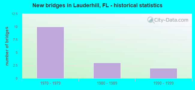
- New bridges - historical statistics
- 101970-1979
- 31980-1989
- 21990-1999


- Bridge Condition - Deck
- 55.6%Good
- 11.1%Satisfactory
- 22.2%Fair
- 11.1%Poor

- Bridge Condition - Superstructure
- 11.1%Very good
- 66.7%Good
- 11.1%Satisfactory
- 11.1%Poor

- Bridge Condition - Substructure
- 77.8%Good
- 22.2%Satisfactory

- Bridge Condition - Channel
- 16.7%Very good
- 83.3%Good
Find on map >> Show street view
Structure Number: 860245, Location: 1 mile west of SR 7 (Lat: 26.164778, Lng: -80.219806), Route carried "on" structure: State highway 816, Year Built: 1978, Status: Open, Structure Length: 10.04m (32.94ft), Average Daily Traffic: 29,250 (year 2020), Truck Traffic: 4%, Average Future Daily Traffic: 50,749 (year 2042), Design Load: HS 20, Features Intersected: SR-91 Fla Turnpike, Facility Carried by Structure: WB Oakland Pk Blvd
Minimum Vertical Clearance: 30+ m (98+ ft), Kilometerpoint: 3.642, Lanes on structure: 3, Lanes under structure: 9, Base Highway Network: Yes, Owner: State Highway Agency, Approaching Roadway Width: 12.8m (42.0ft), Material/Design: Prestressed concrete, Design/Construction: Stringer/Multi-beam, Number Of Spans In Main Unit: 4, Length of Maximum Span: 26.5m (86.9ft), Curb or Sidewalk Widths: Left: 1.5m (4.9ft), Right: 0.0m, Curb-To-Curb Width: 12.8m (42.0ft), Out-to-Out Width: 15.2m (49.9ft)
Condition: Deck: Fair, Superstructure: Good, Substructure: Good, Inventory Rating: 56.4 metric tons, Method Used To Determine Inventory Rating: Load Factor (LF), Structural Evaluation: Better than present minimum criteria, Deck Geometry: Meets minimum limits, Underclear: Somewhat better than minimum adequacy, Approach Roadway Alignment: Equal to present desirable criteria, Designated Inspection Frequency: Every 24 months, Inspection Date: August 2020, Deck Structure Type: Concrete Cast-file-Place
Find on map >> Show street view
Structure Number: 860246, Location: 1 mile west of SR 7 (Lat: 26.164625, Lng: -80.219794), Route carried "on" structure: State highway 816, Year Built: 1978, Status: Open, Structure Length: 10.04m (32.94ft), Average Daily Traffic: 29,250 (year 2020), Truck Traffic: 4%, Average Future Daily Traffic: 50,749 (year 2042), Design Load: HS 20, Features Intersected: SR-91 Fla Turnpike, Facility Carried by Structure: EB Oakland Pk Blvd
Minimum Vertical Clearance: 30+ m (98+ ft), Kilometerpoint: 3.642, Lanes on structure: 3, Lanes under structure: 9, Base Highway Network: Yes, Owner: State Highway Agency, Approaching Roadway Width: 12.8m (42.0ft), Material/Design: Prestressed concrete, Design/Construction: Stringer/Multi-beam, Number Of Spans In Main Unit: 4, Length of Maximum Span: 26.5m (86.9ft), Curb or Sidewalk Widths: Left: 0.0m, Right: 1.5m (4.9ft), Curb-To-Curb Width: 12.8m (42.0ft), Out-to-Out Width: 15.2m (49.9ft)
Condition: Deck: Fair, Superstructure: Good, Substructure: Good, Inventory Rating: 56.4 metric tons, Method Used To Determine Inventory Rating: Load Factor (LF), Structural Evaluation: Better than present minimum criteria, Deck Geometry: Meets minimum limits, Underclear: Somewhat better than minimum adequacy, Approach Roadway Alignment: Equal to present desirable criteria, Designated Inspection Frequency: Every 24 months, Inspection Date: August 2020, Deck Structure Type: Concrete Cast-file-Place
Find on map >> Show street view
Structure Number: 86034, Location: 1mi.E of SR817 on Okld Pk (Lat: 26.165011, Lng: -80.242167), Route carried "on" structure: State highway 816, Year Built: 1975, Year Reconstructed: 2006, Status: Open, Structure Length: 2.93m (9.61ft), Average Daily Traffic: 52,500 (year 2021), Truck Traffic: 9%, Average Future Daily Traffic: 91,088 (year 2042), Design Load: HS 20, Features Intersected: Canal C-13, Facility Carried by Structure: Oakland Park Blvd.
Minimum Vertical Clearance: 30+ m (98+ ft), Kilometerpoint: 1.460, Lanes on structure: 6, Base Highway Network: Yes, Owner: State Highway Agency, Approaching Roadway Width: 28.3m (92.8ft), Skew: 22 degrees, Material/Design: Prestressed concrete, Design/Construction: Slab, Number Of Spans In Main Unit: 3, Length of Maximum Span: 9.8m (32.2ft), Curb or Sidewalk Widths: Left: 1.8m (5.9ft), Right: 1.8m (5.9ft), Curb-To-Curb Width: 28.3m (92.8ft), Out-to-Out Width: 32.6m (107.0ft)
Condition: Deck: Poor, Superstructure: Poor, Substructure: Good, Channel: Very good, Operating Rating: 85.9 metric tons, Method Used To Determine Operating Rating: Load Factor (LF), Inventory Rating: 51.5 metric tons, Method Used To Determine Inventory Rating: Load Factor (LF), Structural Evaluation: Meets minimum limits, Deck Geometry: Superior to present desirable criteria, Waterway Adequacy: Superior to present desirable criteria, Approach Roadway Alignment: Equal to present desirable criteria, Designated Inspection Frequency: Every 24 months, Underwater Inspection Frequency: Every 24 months, Other Special Inspection Frequency: Every 12 months, Inspection Date: April 2021, Underwater Inspection Date: April 2021, Other Special Inspection Date: April 2021, Deck Structure Type: Concrete Precast Panels, Wearing Surface/Protective System: Wearing Surface: Bituminous
Find on map >> Show street view
Structure Number: 860558, Location: 0.3 MI N OF SUNRISE BLVD (Lat: 26.139742, Lng: -80.219261), Route carried "on" structure: Ramp State highway 91, Year Built: 1987, Status: Open, Structure Length: 7.41m (24.31ft), Average Daily Traffic: 5,300 (year 2021), Truck Traffic: 13%, Average Future Daily Traffic: 9,196 (year 2042), Design Load: HS 20, Features Intersected: SR 91 TPK(SUNRSE BV INT)
Minimum Vertical Clearance: 30+ m (98+ ft), Kilometerpoint: 0.402, Lanes on structure: 2, Lanes under structure: 9, Toll: On toll road, Owner: State Toll Authority, Approaching Roadway Width: 15.0m (49.2ft), Skew: 20 degrees, Material/Design: Prestressed concrete, Design/Construction: Stringer/Multi-beam, Number Of Spans In Main Unit: 4, Length of Maximum Span: 23.8m (78.1ft), Curb-To-Curb Width: 13.9m (45.6ft), Out-to-Out Width: 14.9m (48.9ft)
Condition: Deck: Good, Superstructure: Very good, Substructure: Good, Operating Rating: 39.6 metric tons, Method Used To Determine Operating Rating: Load and Resistance Factor (LRFR), Inventory Rating: 35.6 metric tons, Method Used To Determine Inventory Rating: Load and Resistance Factor (LRFR), Structural Evaluation: Better than present minimum criteria, Deck Geometry: Superior to present desirable criteria, Underclear: Equal to present minimum criteria, Approach Roadway Alignment: Somewhat better than minimum adequacy, Designated Inspection Frequency: Every 24 months, Inspection Date: September 2021, Deck Structure Type: Concrete Cast-file-Place
Find on map >> Show street view
Structure Number: 864106, Location: 0.5MI N OF OAKLAND PK BLV (Lat: 26.172794, Lng: -80.220544), Route carried "on" structure: County highway , Year Built: 1995, Status: Open, Structure Length: 1.71m (5.61ft), Average Daily Traffic: 15,000 (year 2021), Truck Traffic: 5%, Average Future Daily Traffic: 20,000 (year 2042), Design Load: HS 20+Mod, Features Intersected: CANAL C-13, Facility Carried by Structure: ROCK ISLAND ROAD
Minimum Vertical Clearance: 30+ m (98+ ft), Kilometerpoint: 0.978, Lanes on structure: 4, Owner: County Highway Agency, Approaching Roadway Width: 17.7m (58.1ft), Skew: 20 degrees, Material/Design: Prestressed concrete, Design/Construction: Stringer/Multi-beam, Number Of Spans In Main Unit: 1, Length of Maximum Span: 17.1m (56.1ft), Curb or Sidewalk Widths: Left: 1.7m (5.6ft), Right: 0.0m, Curb-To-Curb Width: 17.7m (58.1ft), Out-to-Out Width: 24.1m (79.1ft)
Condition: Deck: Good, Superstructure: Good, Substructure: Good, Channel: Good, Operating Rating: 86.2 metric tons, Method Used To Determine Operating Rating: Load Factor (LF), Inventory Rating: 51.7 metric tons, Method Used To Determine Inventory Rating: Load Factor (LF), Structural Evaluation: Better than present minimum criteria, Deck Geometry: Somewhat better than minimum adequacy, Waterway Adequacy: Better than present minimum criteria, Approach Roadway Alignment: Equal to present desirable criteria, Designated Inspection Frequency: Every 24 months, Underwater Inspection Frequency: Every 24 months, Inspection Date: June 2021, Underwater Inspection Date: June 2021, Deck Structure Type: Concrete Cast-file-Place
Find on map >> Show street view
Structure Number: 864107, Location: NW 34TH AVE AT SUNRISE B. (Lat: 26.135886, Lng: -80.192586), Route carried "on" structure: County highway , Year Built: 1995, Status: Open, Structure Length: 2.03m (6.66ft), Average Daily Traffic: 3,000 (year 2021), Truck Traffic: 2%, Average Future Daily Traffic: 3,610 (year 2042), Design Load: HS 20, Features Intersected: C-12 CANAL, Facility Carried by Structure: NW 34TH AVE
Minimum Vertical Clearance: 30+ m (98+ ft), Kilometerpoint: 1.643, Lanes on structure: 4, Owner: County Highway Agency, Approaching Roadway Width: 11.7m (38.4ft), Skew: 20 degrees, Material/Design: Concrete continuous, Design/Construction: Slab, Number Of Spans In Main Unit: 3, Length of Maximum Span: 8.1m (26.6ft), Curb or Sidewalk Widths: Left: 1.9m (6.2ft), Right: 1.9m (6.2ft), Curb-To-Curb Width: 16.6m (54.5ft), Out-to-Out Width: 22.7m (74.5ft)
Condition: Deck: Good, Superstructure: Good, Substructure: Good, Channel: Good, Operating Rating: 65.3 metric tons, Method Used To Determine Operating Rating: Load Factor (LF), Inventory Rating: 39.2 metric tons, Method Used To Determine Inventory Rating: Load Factor (LF), Structural Evaluation: Better than present minimum criteria, Deck Geometry: Somewhat better than minimum adequacy, Waterway Adequacy: Better than present minimum criteria, Approach Roadway Alignment: Equal to present desirable criteria, Designated Inspection Frequency: Every 24 months, Underwater Inspection Frequency: Every 24 months, Inspection Date: June 2021, Underwater Inspection Date: June 2021, Deck Structure Type: Concrete Cast-file-Place
Find on map >> Show street view
Structure Number: 867002, Location: 0.4MI N OF SR-816 (Lat: 26.168728, Lng: -80.231050), Route carried "on" structure: City street , Year Built: 1972, Status: Open, Structure Length: 1.99m (6.53ft), Average Daily Traffic: 18,000 (year 2021), Truck Traffic: 6%, Average Future Daily Traffic: 22,200 (year 2042), Features Intersected: MIDRIVER CANAL BRANCH, Facility Carried by Structure: INVERRARY BLVD
Minimum Vertical Clearance: 30+ m (98+ ft), Kilometerpoint: 2.317, Lanes on structure: 4, Owner: City or Municipal Highway Agency, Approaching Roadway Width: 16.4m (53.8ft), Skew: 31 degrees, Material/Design: Concrete, Design/Construction: Slab, Number Of Spans In Main Unit: 3, Length of Maximum Span: 6.6m (21.7ft), Curb or Sidewalk Widths: Left: 1.0m (3.3ft), Right: 1.0m (3.3ft), Curb-To-Curb Width: 17.1m (56.1ft), Out-to-Out Width: 22.3m (73.2ft)
Condition: Deck: Satisfactory, Superstructure: Satisfactory, Substructure: Satisfactory, Channel: Good, Operating Rating: 54.9 metric tons, Method Used To Determine Operating Rating: Load Factor (LF), Inventory Rating: 32.9 metric tons, Method Used To Determine Inventory Rating: Load Factor (LF), Structural Evaluation: Equal to present minimum criteria, Deck Geometry: Somewhat better than minimum adequacy, Waterway Adequacy: Better than present minimum criteria, Approach Roadway Alignment: Equal to present desirable criteria, Designated Inspection Frequency: Every 24 months, Underwater Inspection Frequency: Every 24 months, Inspection Date: July 2021, Underwater Inspection Date: July 2021, Deck Structure Type: Concrete Precast Panels, Wearing Surface/Protective System: Wearing Surface: Bituminous
Find on map >> Show street view
Structure Number: 867003, Location: 0.8MI N OF OAKLAND PARK (Lat: 26.171206, Lng: -80.236650), Route carried "on" structure: City street , Year Built: 1972, Status: Open, Structure Length: 2.55m (8.37ft), Average Daily Traffic: 18,500 (year 2021), Truck Traffic: 6%, Average Future Daily Traffic: 22,200 (year 2042), Features Intersected: MIDRIVER CANAL, Facility Carried by Structure: INVERRARY BLVD
Minimum Vertical Clearance: 30+ m (98+ ft), Kilometerpoint: 2.932, Lanes on structure: 4, Owner: City or Municipal Highway Agency, Approaching Roadway Width: 15.3m (50.2ft), Skew: 30 degrees, Material/Design: Concrete, Design/Construction: Slab, Number Of Spans In Main Unit: 3, Length of Maximum Span: 8.7m (28.5ft), Curb or Sidewalk Widths: Left: 0.9m (3.0ft), Right: 0.9m (3.0ft), Curb-To-Curb Width: 17.2m (56.4ft), Out-to-Out Width: 22.0m (72.2ft)
Condition: Deck: Good, Superstructure: Good, Substructure: Satisfactory, Channel: Good, Operating Rating: 56.4 metric tons, Method Used To Determine Operating Rating: Load Factor (LF), Inventory Rating: 33.8 metric tons, Method Used To Determine Inventory Rating: Load Factor (LF), Structural Evaluation: Equal to present minimum criteria, Deck Geometry: Somewhat better than minimum adequacy, Waterway Adequacy: Better than present minimum criteria, Approach Roadway Alignment: Better than present minimum criteria, Designated Inspection Frequency: Every 24 months, Underwater Inspection Frequency: Every 24 months, Inspection Date: July 2021, Underwater Inspection Date: July 2021, Deck Structure Type: Concrete Precast Panels, Wearing Surface/Protective System: Wearing Surface: Bituminous
Find on map >> Show street view
Structure Number: 867004, Location: 0.4MI NE OF INVERRARY BLD (Lat: 26.172703, Lng: -80.229911), Route carried "on" structure: City street , Year Built: 1972, Status: Open, Structure Length: 2.55m (8.37ft), Average Daily Traffic: 8,400 (year 2021), Truck Traffic: 5%, Average Future Daily Traffic: 12,145 (year 2042), Features Intersected: MIDRIVER CANAL, Facility Carried by Structure: INVERRARY DR
Minimum Vertical Clearance: 30+ m (98+ ft), Kilometerpoint: 0.000, Lanes on structure: 2, Owner: City or Municipal Highway Agency, Approaching Roadway Width: 7.4m (24.3ft), Material/Design: Concrete, Design/Construction: Slab, Number Of Spans In Main Unit: 3, Length of Maximum Span: 8.6m (28.2ft), Curb or Sidewalk Widths: Left: 0.9m (3.0ft), Right: 0.9m (3.0ft), Curb-To-Curb Width: 8.5m (27.9ft), Out-to-Out Width: 11.1m (36.4ft)
Condition: Deck: Good, Superstructure: Good, Substructure: Good, Channel: Good, Operating Rating: 55.2 metric tons, Method Used To Determine Operating Rating: Load Factor (LF), Inventory Rating: 33.1 metric tons, Method Used To Determine Inventory Rating: Load Factor (LF), Structural Evaluation: Better than present minimum criteria, Deck Geometry: High priority of replacement, Waterway Adequacy: Better than present minimum criteria, Approach Roadway Alignment: Better than present minimum criteria, Designated Inspection Frequency: Every 24 months, Underwater Inspection Frequency: Every 24 months, Inspection Date: July 2021, Underwater Inspection Date: July 2021, Deck Structure Type: Concrete Precast Panels, Wearing Surface/Protective System: Wearing Surface: Bituminous
Find on map >> Show street view
Structure Number: 860245, Location: 1 mile west of SR 7 (Lat: 26.164778, Lng: -80.219806), Route carried "under" structure: City street , Year Built: 1978, Structure Length: 0. m, Average Daily Traffic: 400 (year 2020), Truck Traffic: 2%, Features Intersected: SR-91 Fla Turnpike, Facility Carried by Structure: WB Oakland Pk Blvd
Minimum Vertical Clearance: 5.46m (17.91ft), Kilometerpoint: 0.000, Lanes on structure: 3, Lanes under structure: 2, Material/Design: Prestressed concrete, Design/Construction: Stringer/Multi-beam, Length of Maximum Span: 26.5m (86.9ft)
Find on map >> Show street view
Structure Number: 860245, Location: 1 mile west of SR 7 (Lat: 26.164778, Lng: -80.219806), Route carried "under" structure: State highway 91, Year Built: 1978, Structure Length: 0. m, Average Daily Traffic: 121,800 (year 2020), Truck Traffic: 13%, Features Intersected: SR-91 Fla Turnpike, Facility Carried by Structure: WB Oakland Pk Blvd
Minimum Vertical Clearance: 4.91m (16.11ft), Kilometerpoint: 21.839, Lanes on structure: 3, Lanes under structure: 7, Toll: On toll road, Material/Design: Prestressed concrete, Design/Construction: Stringer/Multi-beam, Length of Maximum Span: 26.5m (86.9ft)
Find on map >> Show street view
Structure Number: 860246, Location: 1 mile west of SR 7 (Lat: 26.164625, Lng: -80.219794), Route carried "under" structure: City street , Year Built: 1978, Structure Length: 0. m, Average Daily Traffic: 400 (year 2020), Truck Traffic: 2%, Features Intersected: SR-91 Fla Turnpike, Facility Carried by Structure: EB Oakland Pk Blvd
Minimum Vertical Clearance: 5.46m (17.91ft), Kilometerpoint: 0.000, Lanes on structure: 3, Lanes under structure: 2, Material/Design: Prestressed concrete, Design/Construction: Stringer/Multi-beam, Length of Maximum Span: 26.5m (86.9ft)
Find on map >> Show street view
Structure Number: 860246, Location: 1 mile west of SR 7 (Lat: 26.164625, Lng: -80.219794), Route carried "under" structure: State highway 91, Year Built: 1978, Structure Length: 0. m, Average Daily Traffic: 121,800 (year 2020), Truck Traffic: 13%, Features Intersected: SR-91 Fla Turnpike, Facility Carried by Structure: EB Oakland Pk Blvd
Minimum Vertical Clearance: 4.91m (16.11ft), Kilometerpoint: 21.819, Lanes on structure: 3, Lanes under structure: 7, Toll: On toll road, Material/Design: Prestressed concrete, Design/Construction: Stringer/Multi-beam, Length of Maximum Span: 26.5m (86.9ft)
Find on map >> Show street view
Structure Number: 860558, Location: 0.3 MI N OF SUNRISE BLVD (Lat: 26.139742, Lng: -80.219261), Route carried "under" structure: State highway 91, Year Built: 1987, Structure Length: 0. m, Average Daily Traffic: 121,800 (year 2021), Truck Traffic: 13%, Features Intersected: SR 91 TPK(SUNRSE BV INT)
Minimum Vertical Clearance: 5.21m (17.09ft), Kilometerpoint: 19.066, Lanes on structure: 2, Lanes under structure: 1, Toll: On toll road, Material/Design: Prestressed concrete, Design/Construction: Stringer/Multi-beam, Length of Maximum Span: 23.8m (78.1ft)
Find on map >> Show street view
Structure Number: 860558, Location: 0.3 MI N OF SUNRISE BLVD (Lat: 26.139742, Lng: -80.219261), Route carried "under" structure: State highway 91, Year Built: 1987, Structure Length: 0. m, Average Daily Traffic: 121,800 (year 2021), Truck Traffic: 13%, Features Intersected: SR 91 TPK(SUNRSE BV INT)
Minimum Vertical Clearance: 5.09m (16.70ft), Kilometerpoint: 19.066, Lanes on structure: 2, Lanes under structure: 8, Toll: On toll road, Material/Design: Prestressed concrete, Design/Construction: Stringer/Multi-beam, Length of Maximum Span: 23.8m (78.1ft)