Bridge Statistics for Laplace, Louisiana (LA)
Condition, Traffic, Stress, Structural Evaluation, Project Costs
- National Bridge Inventory (NBI) Statistics
- 38Number of bridges
- 11,214ft / 3,418mTotal length
- $320,000Total costs
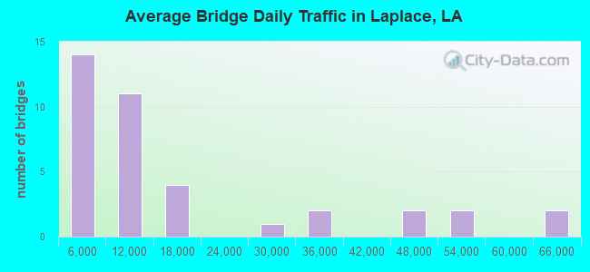
- 569,463Total average daily traffic
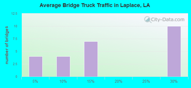
- 60,501Total average daily truck traffic
- National Bridge Inventory (NBI) Registered Bridges for Laplace
- No street view available for this location
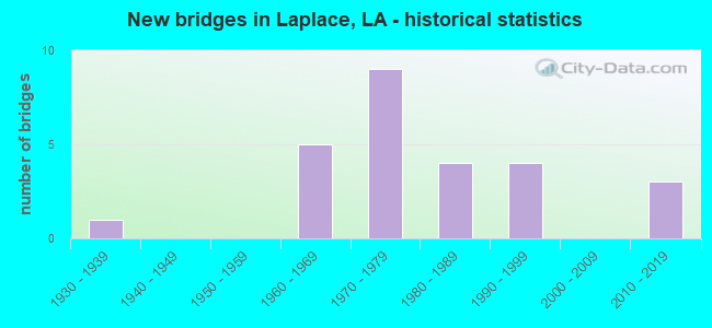
- New bridges - historical statistics
- 11930-1939
- 51960-1969
- 91970-1979
- 41980-1989
- 41990-1999
- 32010-2019
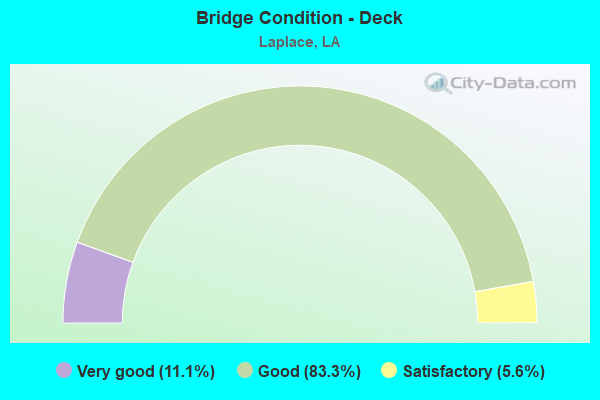
- Bridge Condition - Deck
- 11.1%Very good
- 83.3%Good
- 5.6%Satisfactory
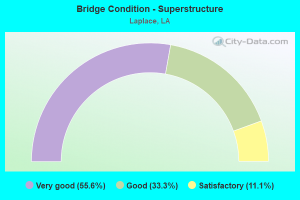
- Bridge Condition - Superstructure
- 55.6%Very good
- 33.3%Good
- 11.1%Satisfactory
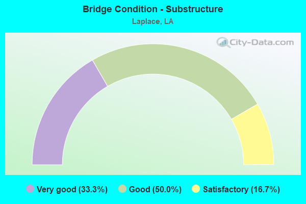
- Bridge Condition - Substructure
- 33.3%Very good
- 50.0%Good
- 16.7%Satisfactory
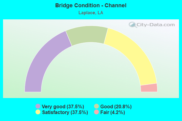
- Bridge Condition - Channel
- 37.5%Very good
- 20.8%Good
- 37.5%Satisfactory
- 4.2%Fair
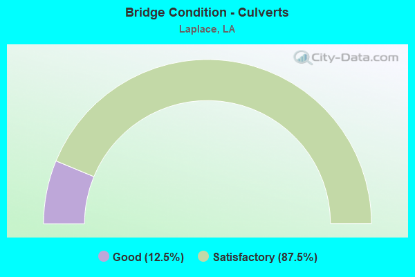
- Bridge Condition - Culverts
- 12.5%Good
- 87.5%Satisfactory
Find on map >> Show street view
Structure Number: 24500070309182, Location: .7 MI WEST OF LA 48 (Lat: 30.032539, Lng: -90.430111), Route carried "on" structure: US 61, Year Built: 1935, Status: Open, Structure Length: 183.06m (600.59ft), Average Daily Traffic: 12,600 (year 2016), Truck Traffic: 10%, Average Future Daily Traffic: 25,806 (year 2036), Design Load: H 15, Features Intersected: BONNET CARRE
Minimum Vertical Clearance: 30+ m (98+ ft), Kilometerpoint: 14.787, Lanes on structure: 2, Base Highway Network: Yes (Inventory Route: 7-03-1, Subroute: 10), Owner: State Highway Agency, Approaching Roadway Width: 18.3m (60.0ft), Skew: 10 degrees, Material/Design: Concrete, Design/Construction: Tee Beam, Number Of Spans In Main Unit: 155, Length of Maximum Span: 11.6m (38.1ft), Curb-To-Curb Width: 12.2m (40.0ft), Out-to-Out Width: 13.9m (45.6ft)
Condition: Deck: Satisfactory, Superstructure: Satisfactory, Substructure: Satisfactory, Channel: Fair, Operating Rating: 41.7 metric tons, Method Used To Determine Operating Rating: Load Factor (LF), Inventory Rating: 25.4 metric tons, Method Used To Determine Inventory Rating: Load Factor (LF), Structural Evaluation: Equal to present minimum criteria, Deck Geometry: Better than present minimum criteria, Waterway Adequacy: Equal to present desirable criteria, Approach Roadway Alignment: Equal to present desirable criteria, Designated Inspection Frequency: Every 24 months, Inspection Date: October 2021, Deck Structure Type: Concrete Cast-file-Place
Find on map >> Show street view
Structure Number: 24504501401459, Location: 3.3 MI EAST OF I-55 (Lat: 30.067711, Lng: -90.390200), Route carried "on" structure: Ramp Interstate 10, Year Built: 1992, Status: Open, Structure Length: 4.11m (13.48ft), Average Daily Traffic: 6,410 (year 2016), Truck Traffic: 25%, Average Future Daily Traffic: 1 (year 2036), Design Load: HS 20, Features Intersected: LAKE PONTCHARTRAIN X-OVE
Minimum Vertical Clearance: 30+ m (98+ ft), Kilometerpoint: 2.350, Lanes on structure: 1, Owner: State Highway Agency, Approaching Roadway Width: 15.9m (52.2ft), Material/Design: Prestressed concrete, Design/Construction: Stringer/Multi-beam, Number Of Spans In Main Unit: 3, Length of Maximum Span: 13.7m (44.9ft), Curb-To-Curb Width: 15.9m (52.2ft), Out-to-Out Width: 16.8m (55.1ft)
Condition: Deck: Good, Superstructure: Very good, Substructure: Good, Channel: Very good, Operating Rating: 59.0 metric tons, Method Used To Determine Operating Rating: Load Factor (LF), Inventory Rating: 35.4 metric tons, Method Used To Determine Inventory Rating: Load Factor (LF), Structural Evaluation: Better than present minimum criteria, Deck Geometry: Superior to present desirable criteria, Waterway Adequacy: Equal to present desirable criteria, Designated Inspection Frequency: Every 24 months, Inspection Date: November 2020, Deck Structure Type: Concrete Cast-file-Place
Find on map >> Show street view
Structure Number: 624800000000048, Location: 0.82 MI. E. OF LA 3188 (Lat: 30.084219, Lng: -90.489961), Route carried "on" structure: City street , Year Built: 2017, Status: Open, Structure Length: 1.52m (4.99ft), Average Daily Traffic: 3,191 (year 2008), Average Future Daily Traffic: 3,510 (year 2028), Design Load: Greater than HL93, Features Intersected: CANAL, Facility Carried by Structure: FAIRWAY DRIVE
Minimum Vertical Clearance: 30+ m (98+ ft), Kilometerpoint: 0.964, Lanes on structure: 2, Owner: Town or Township Highway Agency, Approaching Roadway Width: 11.0m (36.1ft), Material/Design: Concrete, Design/Construction: Slab, Number Of Spans In Main Unit: 2, Length of Maximum Span: 7.6m (24.9ft), Curb or Sidewalk Widths: Left: 0.0m, Right: 1.5m (4.9ft), Curb-To-Curb Width: 11.0m (36.1ft), Out-to-Out Width: 13.4m (44.0ft)
Condition: Deck: Very good, Superstructure: Very good, Substructure: Very good, Channel: Very good, Operating Rating: 59.3 metric tons, Method Used To Determine Operating Rating: Load and Resistance Factor Rating (LRFR) rating reported by rating factor(RF) method using HL-93 loadings, Inventory Rating: 45.7 metric tons, Method Used To Determine Inventory Rating: Load and Resistance Factor Rating (LRFR) rating reported by rating factor(RF) method using HL-93 loadings, Structural Evaluation: Equal to present desirable criteria, Deck Geometry: Somewhat better than minimum adequacy, Waterway Adequacy: Better than present minimum criteria, Approach Roadway Alignment: Better than present minimum criteria, Designated Inspection Frequency: Every 24 months, Inspection Date: Febuary 2021, Deck Structure Type: Concrete Precast Panels
Find on map >> Show street view
Structure Number: 624800000105001, Location: 1.6 MILES NORTH OF LA 61 (Lat: 30.091750, Lng: -90.488289), Route carried "on" structure: County highway , Year Built: 2011, Status: Open, Structure Length: 1.40m (4.59ft), Average Daily Traffic: 100 (year 2011), Truck Traffic: 1%, Average Future Daily Traffic: 60 (year 2036), Design Load: HS 20, Features Intersected: CANAL, Facility Carried by Structure: Country Club Dr
Minimum Vertical Clearance: 30+ m (98+ ft), Kilometerpoint: 0.000, Lanes on structure: 2, Owner: County Highway Agency, Approaching Roadway Width: 7.6m (24.9ft), Material/Design: Concrete, Design/Construction: Slab, Number Of Spans In Main Unit: 2, Length of Maximum Span: 7.0m (23.0ft), Curb or Sidewalk Widths: Left: 0.0m, Right: 1.7m (5.6ft), Curb-To-Curb Width: 8.4m (27.6ft), Out-to-Out Width: 9.4m (30.8ft)
Condition: Deck: Good, Superstructure: Very good, Substructure: Very good, Channel: Very good, Operating Rating: 59.3 metric tons, Method Used To Determine Operating Rating: Load and Resistance Factor Rating (LRFR) rating reported by rating factor(RF) method using HL-93 loadings, Inventory Rating: 45.7 metric tons, Method Used To Determine Inventory Rating: Load and Resistance Factor Rating (LRFR) rating reported by rating factor(RF) method using HL-93 loadings, Structural Evaluation: Equal to present desirable criteria, Deck Geometry: Equal to present minimum criteria, Waterway Adequacy: Better than present minimum criteria, Approach Roadway Alignment: Better than present minimum criteria, Designated Inspection Frequency: Every 24 months, Inspection Date: January 2022, Deck Structure Type: Concrete Precast Panels, Wearing Surface/Protective System: Wearing Surface: Monolithic Concrete
Find on map >> Show street view
Structure Number: 624800000620273, Location: 1.0 MILES SOUTH OF CARROL (Lat: 30.080161, Lng: -90.491211), Route carried "on" structure: County highway , Year Built: 2011, Status: Open, Structure Length: 0.76m (2.49ft), Average Daily Traffic: 500 (year 2011), Truck Traffic: 1%, Average Future Daily Traffic: 300 (year 2036), Design Load: HS 20, Features Intersected: CANAL, Facility Carried by Structure: Greenwood Dr
Minimum Vertical Clearance: 30+ m (98+ ft), Kilometerpoint: 0.000, Lanes on structure: 2, Owner: County Highway Agency, Approaching Roadway Width: 7.3m (24.0ft), Skew: 30 degrees, Material/Design: Concrete, Design/Construction: Slab, Number Of Spans In Main Unit: 1, Length of Maximum Span: 7.6m (24.9ft), Curb or Sidewalk Widths: Left: 1.7m (5.6ft), Right: 1.7m (5.6ft), Curb-To-Curb Width: 8.5m (27.9ft), Out-to-Out Width: 12.8m (42.0ft)
Condition: Deck: Very good, Superstructure: Very good, Substructure: Very good, Channel: Very good, Operating Rating: 56.4 metric tons, Method Used To Determine Operating Rating: Load and Resistance Factor Rating (LRFR) rating reported by rating factor(RF) method using HL-93 loadings, Inventory Rating: 43.4 metric tons, Method Used To Determine Inventory Rating: Load and Resistance Factor Rating (LRFR) rating reported by rating factor(RF) method using HL-93 loadings, Structural Evaluation: Equal to present desirable criteria, Deck Geometry: Somewhat better than minimum adequacy, Waterway Adequacy: Better than present minimum criteria, Approach Roadway Alignment: Better than present minimum criteria, Designated Inspection Frequency: Every 24 months, Inspection Date: March 2020, Deck Structure Type: Concrete Cast-file-Place, Wearing Surface/Protective System: Wearing Surface: Monolithic Concrete
Find on map >> Show street view
Structure Number: 624800000620277, Location: 1.6 MILES EAST OF LA 3188 (Lat: 30.093511, Lng: -90.487431), Route carried "on" structure: County highway , Year Built: 1997, Status: Open, Structure Length: 1.16m (3.81ft), Average Daily Traffic: 300 (year 2011), Truck Traffic: 1%, Average Future Daily Traffic: 180 (year 2036), Design Load: HS 20, Features Intersected: CANAL, Facility Carried by Structure: St. Andrews Blvd.
Minimum Vertical Clearance: 30+ m (98+ ft), Kilometerpoint: 0.000, Lanes on structure: 2, Owner: County Highway Agency, Approaching Roadway Width: 6.7m (22.0ft), Material/Design: Concrete, Design/Construction: Slab, Number Of Spans In Main Unit: 2, Length of Maximum Span: 5.8m (19.0ft), Curb or Sidewalk Widths: Left: 0.0m, Right: 1.1m (3.6ft), Curb-To-Curb Width: 7.6m (24.9ft), Out-to-Out Width: 9.0m (29.5ft)
Condition: Deck: Good, Superstructure: Good, Substructure: Good, Channel: Good, Operating Rating: 48.0 metric tons, Method Used To Determine Operating Rating: Load and Resistance Factor Rating (LRFR) rating reported by rating factor(RF) method using HL-93 loadings, Inventory Rating: 36.9 metric tons, Method Used To Determine Inventory Rating: Load and Resistance Factor Rating (LRFR) rating reported by rating factor(RF) method using HL-93 loadings, Structural Evaluation: Better than present minimum criteria, Deck Geometry: High priority of replacement, Waterway Adequacy: Better than present minimum criteria, Approach Roadway Alignment: Better than present minimum criteria, Length Of Structure Improvement: 1.80m (5.91ft), Designated Inspection Frequency: Every 24 months, Inspection Date: August 2020, Bridge Improvement Cost: $107,000, Total Project Cost: $160,000 ( Estimate for 2016), Deck Structure Type: Concrete Cast-file-Place, Wearing Surface/Protective System: Wearing Surface: Monolithic Concrete
Find on map >> Show street view
Structure Number: 624800000620279, Location: 1.6 MILES EAST OF LA 3188 (Lat: 30.093569, Lng: -90.487411), Route carried "on" structure: County highway , Year Built: 1997, Status: Open, Structure Length: 1.16m (3.81ft), Average Daily Traffic: 300 (year 2011), Truck Traffic: 1%, Average Future Daily Traffic: 180 (year 2036), Design Load: HS 20, Features Intersected: CANAL, Facility Carried by Structure: St. Andrews Blvd.
Minimum Vertical Clearance: 30+ m (98+ ft), Kilometerpoint: 0.000, Lanes on structure: 2, Owner: County Highway Agency, Approaching Roadway Width: 7.3m (24.0ft), Material/Design: Concrete, Design/Construction: Slab, Number Of Spans In Main Unit: 2, Length of Maximum Span: 5.8m (19.0ft), Curb or Sidewalk Widths: Left: 0.0m, Right: 1.1m (3.6ft), Curb-To-Curb Width: 7.6m (24.9ft), Out-to-Out Width: 9.0m (29.5ft)
Condition: Deck: Good, Superstructure: Good, Substructure: Good, Channel: Good, Operating Rating: 48.0 metric tons, Method Used To Determine Operating Rating: Load and Resistance Factor Rating (LRFR) rating reported by rating factor(RF) method using HL-93 loadings, Inventory Rating: 36.9 metric tons, Method Used To Determine Inventory Rating: Load and Resistance Factor Rating (LRFR) rating reported by rating factor(RF) method using HL-93 loadings, Structural Evaluation: Better than present minimum criteria, Deck Geometry: High priority of replacement, Waterway Adequacy: Better than present minimum criteria, Approach Roadway Alignment: Better than present minimum criteria, Length Of Structure Improvement: 1.80m (5.91ft), Designated Inspection Frequency: Every 24 months, Inspection Date: August 2020, Bridge Improvement Cost: $107,000, Total Project Cost: $160,000 ( Estimate for 2016), Deck Structure Type: Concrete Cast-file-Place, Wearing Surface/Protective System: Wearing Surface: Monolithic Concrete
Find on map >> Show street view
Structure Number: 624800000620342, Location: 0.10 Mi. E. of LA 3188 (Lat: 30.105450, Lng: -90.496961), Route carried "on" structure: Interstate 10, Year Built: 1984, Status: Open, Structure Length: 0.94m (3.08ft), Average Daily Traffic: 48,800 (year 2016), Truck Traffic: 26%, Average Future Daily Traffic: 53,680 (year 2036), Features Intersected: Drain
Minimum Vertical Clearance: 30+ m (98+ ft), Kilometerpoint: 14.812, Lanes on structure: 4, Base Highway Network: Yes (Inventory Route: 450-13-1, Subroute: 10), Owner: State Highway Agency, Approaching Roadway Width: 23.8m (78.1ft), Skew: 12 degrees, Material/Design: Steel, Design/Construction: Culvert, Number Of Spans In Main Unit: 3, Length of Maximum Span: 2.4m (7.9ft), Curb-To-Curb Width: 30.5m (100.1ft), Out-to-Out Width: 115.8m (379.9ft)
Condition: Channel: Satisfactory, Culverts: Satisfactory, Operating Rating: 97.2 metric tons, Method Used To Determine Operating Rating: Load and Resistance Factor Rating (LRFR) rating reported by rating factor(RF) method using HL-93 loadings, Inventory Rating: 74.5 metric tons, Method Used To Determine Inventory Rating: Load and Resistance Factor Rating (LRFR) rating reported by rating factor(RF) method using HL-93 loadings, Structural Evaluation: Equal to present minimum criteria, Deck Geometry: Superior to present desirable criteria, Waterway Adequacy: Equal to present minimum criteria, Approach Roadway Alignment: Better than present minimum criteria, Designated Inspection Frequency: Every 24 months, Inspection Date: June 2021
Find on map >> Show street view
Structure Number: 624800000620343, Location: 0.75 Mi. E. of LA 3188 (Lat: 30.101881, Lng: -90.485950), Route carried "on" structure: Interstate 10, Year Built: 1984, Status: Open, Structure Length: 2.01m (6.59ft), Average Daily Traffic: 48,800 (year 2016), Truck Traffic: 26%, Average Future Daily Traffic: 53,680 (year 2036), Features Intersected: Drain
Minimum Vertical Clearance: 30+ m (98+ ft), Kilometerpoint: 15.945, Lanes on structure: 4, Base Highway Network: Yes (Inventory Route: 450-13-1, Subroute: 10), Owner: State Highway Agency, Approaching Roadway Width: 23.8m (78.1ft), Skew: 12 degrees, Material/Design: Steel, Design/Construction: Culvert, Number Of Spans In Main Unit: 6, Length of Maximum Span: 2.4m (7.9ft), Curb-To-Curb Width: 30.5m (100.1ft), Out-to-Out Width: 121.9m (399.9ft)
Condition: Channel: Satisfactory, Culverts: Satisfactory, Operating Rating: 97.2 metric tons, Method Used To Determine Operating Rating: Load and Resistance Factor Rating (LRFR) rating reported by rating factor(RF) method using HL-93 loadings, Inventory Rating: 74.5 metric tons, Method Used To Determine Inventory Rating: Load and Resistance Factor Rating (LRFR) rating reported by rating factor(RF) method using HL-93 loadings, Structural Evaluation: Equal to present minimum criteria, Deck Geometry: Superior to present desirable criteria, Waterway Adequacy: Equal to present minimum criteria, Approach Roadway Alignment: Better than present minimum criteria, Designated Inspection Frequency: Every 24 months, Inspection Date: June 2021
Find on map >> Show street view
Structure Number: 624804340100001, Location: GRAMERCY (Lat: 30.036939, Lng: -90.667289), Route carried "on" structure: State highway 3213, Year Built: 1995, Status: Open, Structure Length: 75.26m (246.92ft), Average Daily Traffic: 12,300 (year 2016), Truck Traffic: 11%, Average Future Daily Traffic: 7,260 (year 2036), Design Load: HS 20, Features Intersected: GRAMERCY BRIDGE WEST BAN
Minimum Vertical Clearance: 30+ m (98+ ft), Kilometerpoint: 4.270, Lanes on structure: 4, Lanes under structure: 2, Base Highway Network: Yes (Inventory Route: 434-01-1, Subroute: 10), Owner: State Highway Agency, Approaching Roadway Width: 23.5m (77.1ft), Skew: 30 degrees, Material/Design: Prestressed concrete, Design/Construction: Stringer/Multi-beam, Number Of Spans In Main Unit: 21, Length of Maximum Span: 83.8m (274.9ft), Curb-To-Curb Width: 22.6m (74.1ft), Out-to-Out Width: 23.4m (76.8ft)
Condition: Deck: Good, Superstructure: Satisfactory, Substructure: Good, Operating Rating: 63.5 metric tons, Method Used To Determine Operating Rating: Load Factor (LF), Inventory Rating: 38.1 metric tons, Method Used To Determine Inventory Rating: Load Factor (LF), Structural Evaluation: Equal to present minimum criteria, Deck Geometry: Superior to present desirable criteria, Underclear: Superior to present desirable criteria, Approach Roadway Alignment: Equal to present desirable criteria, Designated Inspection Frequency: Every 24 months, Critical Feature Inspection Frequency: Every 24 months, Inspection Date: August 2021, Critical Feature Inspection Date: August 2021, Deck Structure Type: Other
Find on map >> Show street view
Structure Number: 624804501312071, Location: I0010 (Lat: 30.089450, Lng: -90.445400), Route carried "on" structure: Interstate 10, Year Built: 1972, Status: Open, Structure Length: 358.23m (1175.30ft), Average Daily Traffic: 32,050 (year 2016), Truck Traffic: 26%, Average Future Daily Traffic: 22,752 (year 2036), Design Load: HS 20, Features Intersected: US 51 & SWAMPS
Minimum Vertical Clearance: 30+ m (98+ ft), Kilometerpoint: 20.123, Lanes on structure: 2, Lanes under structure: 4, Base Highway Network: Yes (Inventory Route: 450-13-1, Subroute: 10), Owner: State Highway Agency, Approaching Roadway Width: 20.1m (65.9ft), Skew: 10 degrees, Material/Design: Prestressed concrete, Design/Construction: Stringer/Multi-beam, Number Of Spans In Main Unit: 176, Number Of Approach Spans: 10, Length of Maximum Span: 25.3m (83.0ft), Curb-To-Curb Width: 11.9m (39.0ft), Out-to-Out Width: 13.4m (44.0ft)
Condition: Deck: Good, Superstructure: Very good, Substructure: Good, Channel: Good, Operating Rating: 68.0 metric tons, Method Used To Determine Operating Rating: Load Factor (LF), Inventory Rating: 33.6 metric tons, Method Used To Determine Inventory Rating: Load Factor (LF), Structural Evaluation: Better than present minimum criteria, Deck Geometry: Equal to present minimum criteria, Underclear: Superior to present desirable criteria, Waterway Adequacy: Equal to present desirable criteria, Approach Roadway Alignment: Equal to present desirable criteria, Designated Inspection Frequency: Every 24 months, Inspection Date: June 2021, Deck Structure Type: Concrete Cast-file-Place
Find on map >> Show street view
Structure Number: 624804501312072, Location: I0010 (Lat: 30.079589, Lng: -90.410000), Route carried "on" structure: Interstate 10, Year Built: 1972, Status: Open, Structure Length: 357.10m (1171.59ft), Average Daily Traffic: 32,050 (year 2016), Truck Traffic: 26%, Average Future Daily Traffic: 22,752 (year 2036), Design Load: HS 20, Features Intersected: US 51 & SWAMPS
Minimum Vertical Clearance: 30+ m (98+ ft), Kilometerpoint: 0.000, Lanes on structure: 2, Lanes under structure: 4, Base Highway Network: Yes (Inventory Route: 450-13-2, Subroute: 10), Owner: State Highway Agency, Approaching Roadway Width: 20.1m (65.9ft), Skew: 10 degrees, Material/Design: Prestressed concrete, Design/Construction: Stringer/Multi-beam, Number Of Spans In Main Unit: 177, Number Of Approach Spans: 10, Length of Maximum Span: 25.3m (83.0ft), Curb-To-Curb Width: 11.9m (39.0ft), Out-to-Out Width: 13.4m (44.0ft)
Condition: Deck: Good, Superstructure: Very good, Substructure: Very good, Channel: Very good, Operating Rating: 68.0 metric tons, Method Used To Determine Operating Rating: Load Factor (LF), Inventory Rating: 36.3 metric tons, Method Used To Determine Inventory Rating: Load Factor (LF), Structural Evaluation: Equal to present desirable criteria, Deck Geometry: Equal to present minimum criteria, Underclear: Superior to present desirable criteria, Waterway Adequacy: Equal to present desirable criteria, Approach Roadway Alignment: Equal to present desirable criteria, Designated Inspection Frequency: Every 24 months, Inspection Date: June 2021, Deck Structure Type: Concrete Cast-file-Place
Find on map >> Show street view
Structure Number: 624804501312495, Location: I0010 (Lat: 30.087489, Lng: -90.440700), Route carried "on" structure: Ramp Interstate 10, Year Built: 1972, Status: Open, Structure Length: 16.92m (55.51ft), Average Daily Traffic: 6,410 (year 2016), Truck Traffic: 26%, Average Future Daily Traffic: 3,792 (year 2036), Design Load: HS 20, Features Intersected: EB ON RAMP (US51)
Minimum Vertical Clearance: 30+ m (98+ ft), Kilometerpoint: 0.183, Lanes on structure: 1, Owner: State Highway Agency, Approaching Roadway Width: 11.0m (36.1ft), Material/Design: Prestressed concrete, Design/Construction: Stringer/Multi-beam, Number Of Spans In Main Unit: 8, Number Of Approach Spans: 7, Length of Maximum Span: 15.2m (49.9ft), Curb-To-Curb Width: 7.6m (24.9ft), Out-to-Out Width: 8.8m (28.9ft)
Condition: Deck: Good, Superstructure: Very good, Substructure: Very good, Channel: Good, Operating Rating: 69.8 metric tons, Method Used To Determine Operating Rating: Load Factor (LF), Inventory Rating: 41.7 metric tons, Method Used To Determine Inventory Rating: Load Factor (LF), Structural Evaluation: Equal to present desirable criteria, Deck Geometry: Better than present minimum criteria, Waterway Adequacy: Equal to present desirable criteria, Approach Roadway Alignment: Equal to present desirable criteria, Designated Inspection Frequency: Every 24 months, Inspection Date: June 2021, Deck Structure Type: Concrete Cast-file-Place
Find on map >> Show street view
Structure Number: 624804501312528, Location: 10.4 Mi. W. of I-310 (Lat: 30.087700, Lng: -90.437900), Route carried "on" structure: Ramp Interstate 10, Year Built: 1972, Status: Open, Structure Length: 13.26m (43.50ft), Average Daily Traffic: 6,410 (year 2016), Truck Traffic: 26%, Average Future Daily Traffic: 3,792 (year 2036), Design Load: HS 20, Features Intersected: WB OFF RAMP (US51)
Minimum Vertical Clearance: 30+ m (98+ ft), Kilometerpoint: 0.143, Lanes on structure: 1, Owner: State Highway Agency, Approaching Roadway Width: 12.2m (40.0ft), Material/Design: Prestressed concrete, Design/Construction: Stringer/Multi-beam, Number Of Spans In Main Unit: 6, Number Of Approach Spans: 5, Length of Maximum Span: 16.8m (55.1ft), Curb-To-Curb Width: 7.6m (24.9ft), Out-to-Out Width: 8.8m (28.9ft)
Condition: Deck: Good, Superstructure: Very good, Substructure: Very good, Channel: Very good, Operating Rating: 69.8 metric tons, Method Used To Determine Operating Rating: Load Factor (LF), Inventory Rating: 34.5 metric tons, Method Used To Determine Inventory Rating: Load Factor (LF), Structural Evaluation: Equal to present desirable criteria, Deck Geometry: Better than present minimum criteria, Waterway Adequacy: Equal to present desirable criteria, Approach Roadway Alignment: Equal to present desirable criteria, Designated Inspection Frequency: Every 24 months, Inspection Date: June 2021, Deck Structure Type: Concrete Cast-file-Place
Find on map >> Show street view
Structure Number: 624804520100001, Location: I055 (Lat: 30.085631, Lng: -90.431011), Route carried "on" structure: Interstate 55, Year Built: 1975, Status: Open, Structure Length: 2311.33m (7583.10ft), Average Daily Traffic: 24,000 (year 2016), Truck Traffic: 25%, Average Future Daily Traffic: 8,424 (year 2036), Design Load: HS 20, Features Intersected: I-55 OVER US 51 & SWAMP
Minimum Vertical Clearance: 30+ m (98+ ft), Kilometerpoint: 0.002, Lanes on structure: 2, Lanes under structure: 4, Base Highway Network: Yes (Inventory Route: 452-01-1, Subroute: 10), Owner: State Highway Agency, Approaching Roadway Width: 11.9m (39.0ft), Skew: 10 degrees, Material/Design: Prestressed concrete, Design/Construction: Stringer/Multi-beam, Number Of Spans In Main Unit: 223, Length of Maximum Span: 21.3m (69.9ft), Curb-To-Curb Width: 11.9m (39.0ft), Out-to-Out Width: 13.0m (42.7ft)
Condition: Deck: Good, Superstructure: Good, Substructure: Good, Channel: Very good, Operating Rating: 59.0 metric tons, Method Used To Determine Operating Rating: Load Factor (LF), Inventory Rating: 35.4 metric tons, Method Used To Determine Inventory Rating: Load Factor (LF), Structural Evaluation: Better than present minimum criteria, Deck Geometry: Somewhat better than minimum adequacy, Waterway Adequacy: Equal to present desirable criteria, Approach Roadway Alignment: Equal to present desirable criteria, Designated Inspection Frequency: Every 24 months, Underwater Inspection Frequency: Every 60 months, Inspection Date: June 2021, Underwater Inspection Date: Febuary 2020, Deck Structure Type: Concrete Cast-file-Place
Find on map >> Show street view
Structure Number: 624804520100533, Location: 0.1 M NE OF I-55 (Lat: 30.094911, Lng: -90.437261), Route carried "on" structure: US 51, Year Built: 1975, Status: Open, Structure Length: 2.74m (8.99ft), Average Daily Traffic: 761 (year 2016), Truck Traffic: 9%, Average Future Daily Traffic: 456 (year 2036), Design Load: HS 20, Features Intersected: DRAINAGE CANAL
Minimum Vertical Clearance: 30+ m (98+ ft), Kilometerpoint: 5.655, Lanes on structure: 3, Base Highway Network: Yes (Inventory Route: 256-12-1, Subroute: 10), Owner: State Highway Agency, Approaching Roadway Width: 14.9m (48.9ft), Skew: 10 degrees, Material/Design: Concrete, Design/Construction: Slab, Number Of Spans In Main Unit: 3, Length of Maximum Span: 9.1m (29.9ft), Curb-To-Curb Width: 15.2m (49.9ft), Out-to-Out Width: 16.8m (55.1ft)
Condition: Deck: Good, Superstructure: Good, Substructure: Satisfactory, Channel: Satisfactory, Operating Rating: 64.4 metric tons, Method Used To Determine Operating Rating: Load Factor (LF), Inventory Rating: 38.1 metric tons, Method Used To Determine Inventory Rating: Load Factor (LF), Structural Evaluation: Equal to present minimum criteria, Deck Geometry: Equal to present minimum criteria, Waterway Adequacy: Equal to present minimum criteria, Approach Roadway Alignment: Equal to present minimum criteria, Designated Inspection Frequency: Every 24 months, Underwater Inspection Frequency: Every 60 months, Inspection Date: June 2021, Underwater Inspection Date: June 2019, Deck Structure Type: Concrete Cast-file-Place
Find on map >> Show street view
Structure Number: 624804520100534, Location: 0.1 M NE OF I-55 (Lat: 30.095150, Lng: -90.437461), Route carried "on" structure: US 51, Year Built: 1975, Status: Open, Structure Length: 2.74m (8.99ft), Average Daily Traffic: 761 (year 2016), Truck Traffic: 9%, Average Future Daily Traffic: 456 (year 2036), Design Load: HS 20, Features Intersected: DRAINAGE CANAL
Minimum Vertical Clearance: 30+ m (98+ ft), Kilometerpoint: 0.101, Lanes on structure: 2, Owner: State Highway Agency, Approaching Roadway Width: 14.9m (48.9ft), Skew: 10 degrees, Material/Design: Concrete, Design/Construction: Slab, Number Of Spans In Main Unit: 3, Length of Maximum Span: 9.1m (29.9ft), Curb-To-Curb Width: 11.3m (37.1ft), Out-to-Out Width: 16.8m (55.1ft)
Condition: Deck: Good, Superstructure: Good, Substructure: Satisfactory, Channel: Good, Operating Rating: 71.7 metric tons, Method Used To Determine Operating Rating: Load Factor (LF), Inventory Rating: 42.6 metric tons, Method Used To Determine Inventory Rating: Load Factor (LF), Structural Evaluation: Equal to present minimum criteria, Deck Geometry: Equal to present minimum criteria, Waterway Adequacy: Equal to present minimum criteria, Approach Roadway Alignment: Equal to present minimum criteria, Designated Inspection Frequency: Every 24 months, Underwater Inspection Frequency: Every 60 months, Inspection Date: June 2021, Underwater Inspection Date: June 2019, Deck Structure Type: Concrete Cast-file-Place
Find on map >> Show street view
Structure Number: 624804520100908, Location: 0.1 M N OF US 51 (Lat: 30.094811, Lng: -90.439000), Route carried "on" structure: Ramp Interstate 55, Year Built: 1975, Status: Open, Structure Length: 20.57m (67.49ft), Average Daily Traffic: 2,400 (year 2016), Truck Traffic: 26%, Average Future Daily Traffic: 1,404 (year 2036), Design Load: HS 20, Features Intersected: I-55 OFF RAMP @ US 51
Minimum Vertical Clearance: 30+ m (98+ ft), Kilometerpoint: 0.158, Lanes on structure: 1, Owner: State Highway Agency, Approaching Roadway Width: 12.5m (41.0ft), Material/Design: Prestressed concrete, Design/Construction: Stringer/Multi-beam, Number Of Spans In Main Unit: 10, Number Of Approach Spans: 3, Length of Maximum Span: 18.3m (60.0ft), Curb-To-Curb Width: 7.6m (24.9ft), Out-to-Out Width: 8.5m (27.9ft)
Condition: Deck: Good, Superstructure: Very good, Substructure: Good, Channel: Very good, Operating Rating: 89.8 metric tons, Method Used To Determine Operating Rating: Load Factor (LF), Inventory Rating: 35.4 metric tons, Method Used To Determine Inventory Rating: Load Factor (LF), Structural Evaluation: Better than present minimum criteria, Deck Geometry: Better than present minimum criteria, Waterway Adequacy: Equal to present desirable criteria, Approach Roadway Alignment: Equal to present desirable criteria, Designated Inspection Frequency: Every 24 months, Inspection Date: June 2021, Deck Structure Type: Concrete Cast-file-Place
Find on map >> Show street view
Structure Number: 624804520100955, Location: 0.1 M W OF US 51 (Lat: 30.096481, Lng: -90.438700), Route carried "on" structure: Ramp Interstate 55, Year Built: 1975, Status: Open, Structure Length: 16.92m (55.51ft), Average Daily Traffic: 2,400 (year 2016), Truck Traffic: 26%, Average Future Daily Traffic: 1,404 (year 2036), Design Load: HS 20, Features Intersected: I-55 ON RAMP NORTH @ US5
Minimum Vertical Clearance: 30+ m (98+ ft), Kilometerpoint: 0.153, Lanes on structure: 1, Owner: State Highway Agency, Approaching Roadway Width: 8.5m (27.9ft), Material/Design: Prestressed concrete, Design/Construction: Stringer/Multi-beam, Number Of Spans In Main Unit: 10, Number Of Approach Spans: 3, Length of Maximum Span: 18.3m (60.0ft), Curb-To-Curb Width: 7.6m (24.9ft), Out-to-Out Width: 8.7m (28.5ft)
Condition: Deck: Good, Superstructure: Very good, Substructure: Good, Channel: Very good, Operating Rating: 80.7 metric tons, Method Used To Determine Operating Rating: Load Factor (LF), Inventory Rating: 34.5 metric tons, Method Used To Determine Inventory Rating: Load Factor (LF), Structural Evaluation: Better than present minimum criteria, Deck Geometry: Better than present minimum criteria, Waterway Adequacy: Equal to present desirable criteria, Approach Roadway Alignment: Equal to present desirable criteria, Designated Inspection Frequency: Every 24 months, Inspection Date: June 2021, Deck Structure Type: Concrete Cast-file-Place
Find on map >> Show street view
Structure Number: 624804520101153, Location: NORTH OF US 51 & I55 EXIT (Lat: 30.103111, Lng: -90.440000), Route carried "on" structure: ServiceInterstate 55, Year Built: 1960, Status: Open, Structure Length: 0.82m (2.69ft), Average Daily Traffic: 2,400 (year 2016), Truck Traffic: 12%, Average Future Daily Traffic: 1,404 (year 2036), Design Load: HS 20, Features Intersected: DRAIN PIPE XING
Minimum Vertical Clearance: 30+ m (98+ ft), Kilometerpoint: 0.818, Lanes on structure: 2, Owner: State Highway Agency, Approaching Roadway Width: 13.4m (44.0ft), Material/Design: Concrete, Design/Construction: Culvert, Number Of Spans In Main Unit: 5, Length of Maximum Span: 1.2m (3.9ft), Curb-To-Curb Width: 13.1m (43.0ft), Out-to-Out Width: 20.7m (67.9ft)
Condition: Channel: Satisfactory, Culverts: Satisfactory, Operating Rating: 42.1 metric tons, Method Used To Determine Operating Rating: Load and Resistance Factor Rating (LRFR) rating reported by rating factor(RF) method using HL-93 loadings, Inventory Rating: 32.4 metric tons, Method Used To Determine Inventory Rating: Load and Resistance Factor Rating (LRFR) rating reported by rating factor(RF) method using HL-93 loadings, Structural Evaluation: Equal to present minimum criteria, Deck Geometry: Equal to present minimum criteria, Waterway Adequacy: Equal to present minimum criteria, Approach Roadway Alignment: Equal to present desirable criteria, Designated Inspection Frequency: Every 24 months, Inspection Date: June 2021
Find on map >> Show street view
Structure Number: 624804520102553, Location: 2.0 M N - I55 & US51 EXIT (Lat: 30.122061, Lng: -90.445700), Route carried "on" structure: ServiceInterstate 55, Year Built: 1960, Status: Open, Structure Length: 0.98m (3.22ft), Average Daily Traffic: 2,400 (year 2016), Truck Traffic: 12%, Average Future Daily Traffic: 1,404 (year 2036), Design Load: HS 20, Features Intersected: DRAIN PIPE XING
Minimum Vertical Clearance: 30+ m (98+ ft), Kilometerpoint: 2.987, Lanes on structure: 2, Owner: State Highway Agency, Approaching Roadway Width: 13.4m (44.0ft), Material/Design: Concrete, Design/Construction: Culvert, Number Of Spans In Main Unit: 7, Length of Maximum Span: 1.2m (3.9ft), Curb-To-Curb Width: 13.1m (43.0ft), Out-to-Out Width: 20.7m (67.9ft)
Condition: Channel: Satisfactory, Culverts: Satisfactory, Operating Rating: 42.1 metric tons, Method Used To Determine Operating Rating: Load and Resistance Factor Rating (LRFR) rating reported by rating factor(RF) method using HL-93 loadings, Inventory Rating: 32.4 metric tons, Method Used To Determine Inventory Rating: Load and Resistance Factor Rating (LRFR) rating reported by rating factor(RF) method using HL-93 loadings, Structural Evaluation: Equal to present minimum criteria, Deck Geometry: Equal to present minimum criteria, Waterway Adequacy: Equal to present minimum criteria, Approach Roadway Alignment: Better than present minimum criteria, Designated Inspection Frequency: Every 24 months, Inspection Date: June 2021
Find on map >> Show street view
Structure Number: 624804520102953, Location: 2.4 M N - I55 & US51 EXIT (Lat: 30.127681, Lng: -90.447300), Route carried "on" structure: ServiceInterstate 55, Year Built: 1960, Status: Open, Structure Length: 0.82m (2.69ft), Average Daily Traffic: 2,400 (year 2016), Truck Traffic: 12%, Average Future Daily Traffic: 1,404 (year 2036), Design Load: HS 20, Features Intersected: DRAIN PIPE XING
Minimum Vertical Clearance: 30+ m (98+ ft), Kilometerpoint: 3.631, Lanes on structure: 2, Owner: State Highway Agency, Approaching Roadway Width: 13.4m (44.0ft), Material/Design: Concrete, Design/Construction: Culvert, Number Of Spans In Main Unit: 5, Length of Maximum Span: 1.2m (3.9ft), Curb-To-Curb Width: 13.1m (43.0ft), Out-to-Out Width: 19.5m (64.0ft)
Condition: Channel: Satisfactory, Culverts: Satisfactory, Operating Rating: 42.1 metric tons, Method Used To Determine Operating Rating: Load and Resistance Factor Rating (LRFR) rating reported by rating factor(RF) method using HL-93 loadings, Inventory Rating: 32.4 metric tons, Method Used To Determine Inventory Rating: Load and Resistance Factor Rating (LRFR) rating reported by rating factor(RF) method using HL-93 loadings, Structural Evaluation: Equal to present minimum criteria, Deck Geometry: Equal to present minimum criteria, Waterway Adequacy: Somewhat better than minimum adequacy, Approach Roadway Alignment: Equal to present desirable criteria, Designated Inspection Frequency: Every 24 months, Inspection Date: June 2021
Find on map >> Show street view
Structure Number: 624804520103503, Location: 3 MI N - I55 & US 51 JCT (Lat: 30.135169, Lng: -90.449500), Route carried "on" structure: ServiceInterstate 55, Year Built: 1960, Status: Open, Structure Length: 0.82m (2.69ft), Average Daily Traffic: 2,400 (year 2016), Truck Traffic: 12%, Average Future Daily Traffic: 1,404 (year 2036), Design Load: HS 20, Features Intersected: DRAIN PIPE XING
Minimum Vertical Clearance: 30+ m (98+ ft), Kilometerpoint: 4.488, Lanes on structure: 2, Owner: State Highway Agency, Approaching Roadway Width: 13.4m (44.0ft), Material/Design: Concrete, Design/Construction: Culvert, Number Of Spans In Main Unit: 5, Length of Maximum Span: 1.2m (3.9ft), Curb-To-Curb Width: 13.1m (43.0ft), Out-to-Out Width: 19.5m (64.0ft)
Condition: Channel: Satisfactory, Culverts: Satisfactory, Operating Rating: 42.1 metric tons, Method Used To Determine Operating Rating: Load and Resistance Factor Rating (LRFR) rating reported by rating factor(RF) method using HL-93 loadings, Inventory Rating: 32.4 metric tons, Method Used To Determine Inventory Rating: Load and Resistance Factor Rating (LRFR) rating reported by rating factor(RF) method using HL-93 loadings, Structural Evaluation: Equal to present minimum criteria, Deck Geometry: Equal to present minimum criteria, Waterway Adequacy: Equal to present minimum criteria, Approach Roadway Alignment: Equal to present desirable criteria, Designated Inspection Frequency: Every 24 months, Inspection Date: June 2021
Find on map >> Show street view
Structure Number: 624804520104103, Location: M N - US51 & I55 JCT (Lat: 30.143331, Lng: -90.449300), Route carried "on" structure: ServiceInterstate 55, Year Built: 1960, Status: Open, Structure Length: 0.82m (2.69ft), Average Daily Traffic: 2,400 (year 2016), Truck Traffic: 12%, Average Future Daily Traffic: 1,404 (year 2036), Design Load: HS 20, Features Intersected: DRAIN PIPE XING
Minimum Vertical Clearance: 30+ m (98+ ft), Kilometerpoint: 5.412, Lanes on structure: 2, Owner: State Highway Agency, Approaching Roadway Width: 13.4m (44.0ft), Material/Design: Concrete, Design/Construction: Culvert, Number Of Spans In Main Unit: 5, Length of Maximum Span: 1.2m (3.9ft), Curb-To-Curb Width: 13.1m (43.0ft), Out-to-Out Width: 19.5m (64.0ft)
Condition: Channel: Satisfactory, Culverts: Satisfactory, Operating Rating: 42.1 metric tons, Method Used To Determine Operating Rating: Load and Resistance Factor Rating (LRFR) rating reported by rating factor(RF) method using HL-93 loadings, Inventory Rating: 32.4 metric tons, Method Used To Determine Inventory Rating: Load and Resistance Factor Rating (LRFR) rating reported by rating factor(RF) method using HL-93 loadings, Structural Evaluation: Equal to present minimum criteria, Deck Geometry: Equal to present minimum criteria, Waterway Adequacy: Somewhat better than minimum adequacy, Approach Roadway Alignment: Equal to present desirable criteria, Designated Inspection Frequency: Every 24 months, Inspection Date: June 2021
Find on map >> Show street view
Structure Number: 624808481501451, Location: 1.45 MI. NO. U.S. 61 (Lat: 30.093239, Lng: -90.504600), Route carried "on" structure: State highway 3188, Year Built: 1983, Status: Open, Structure Length: 0.67m (2.20ft), Average Daily Traffic: 17,300 (year 2016), Truck Traffic: 6%, Average Future Daily Traffic: 10,320 (year 2036), Design Load: HS 20, Features Intersected: DRAIN
Minimum Vertical Clearance: 30+ m (98+ ft), Kilometerpoint: 2.242, Lanes on structure: 4, Base Highway Network: Yes (Inventory Route: 848-15-1, Subroute: 10), Owner: State Highway Agency, Approaching Roadway Width: 38.1m (125.0ft), Material/Design: Concrete, Design/Construction: Culvert, Length of Maximum Span: 1.8m (5.9ft)
Condition: Channel: Satisfactory, Culverts: Good, Operating Rating: 42.1 metric tons, Method Used To Determine Operating Rating: Load and Resistance Factor Rating (LRFR) rating reported by rating factor(RF) method using HL-93 loadings, Inventory Rating: 32.4 metric tons, Method Used To Determine Inventory Rating: Load and Resistance Factor Rating (LRFR) rating reported by rating factor(RF) method using HL-93 loadings, Structural Evaluation: Better than present minimum criteria, Waterway Adequacy: Meets minimum limits, Approach Roadway Alignment: Equal to present desirable criteria, Designated Inspection Frequency: Every 24 months, Inspection Date: June 2021
Find on map >> Show street view
Structure Number: 624808481502351, Location: 2.2 M N OF US 61 (Lat: 30.106411, Lng: -90.498100), Route carried "on" structure: State highway 3188, Year Built: 1984, Status: Open, Structure Length: 41.61m (136.52ft), Average Daily Traffic: 17,300 (year 2016), Truck Traffic: 6%, Average Future Daily Traffic: 10,320 (year 2036), Design Load: HS 20, Features Intersected: LA 3188 OVER I-10
Minimum Vertical Clearance: 30+ m (98+ ft), Kilometerpoint: 0.970, Lanes on structure: 2, Lanes under structure: 5, Base Highway Network: Yes (Inventory Route: 848-15-2, Subroute: 10), Owner: State Highway Agency, Approaching Roadway Width: 13.4m (44.0ft), Skew: 6 degrees, Material/Design: Prestressed concrete, Design/Construction: Stringer/Multi-beam, Number Of Spans In Main Unit: 18, Length of Maximum Span: 31.4m (103.0ft), Curb-To-Curb Width: 13.4m (44.0ft), Out-to-Out Width: 14.3m (46.9ft)
Condition: Deck: Good, Superstructure: Good, Substructure: Good, Operating Rating: 60.8 metric tons, Method Used To Determine Operating Rating: Load Factor (LF), Inventory Rating: 36.3 metric tons, Method Used To Determine Inventory Rating: Load Factor (LF), Structural Evaluation: Better than present minimum criteria, Deck Geometry: Equal to present minimum criteria, Underclear: Somewhat better than minimum adequacy, Approach Roadway Alignment: Equal to present desirable criteria, Designated Inspection Frequency: Every 24 months, Inspection Date: June 2021, Deck Structure Type: Concrete Cast-file-Place
Find on map >> Show street view
Structure Number: 624804501312071, Location: 0.3 MI S OF I-55 (Lat: 30.088319, Lng: -90.441689), Route carried "under" structure: US 51, Structure Length: 0. m, Average Daily Traffic: 7,615 (year 2014), Features Intersected: US 51 NB UNDER I-10 EB
Minimum Vertical Clearance: 5.36m (17.59ft), Kilometerpoint: 4.797, Lanes on structure: 2, Length of Maximum Span: 0.0m
Find on map >> Show street view
Structure Number: 624804501312071, Location: 0.3 MI S OF I-55 (Lat: 30.088481, Lng: -90.441819), Route carried "under" structure: US 51, Structure Length: 0. m, Average Daily Traffic: 7,615 (year 2014), Features Intersected: US 51 SB UNDER I-10 EB
Minimum Vertical Clearance: 5.52m (18.11ft), Kilometerpoint: 0.970, Lanes on structure: 2, Length of Maximum Span: 0.0m
Find on map >> Show street view
Structure Number: 624804501312072, Location: 0.3 MI S OF I-55 (Lat: 30.088531, Lng: -90.441481), Route carried "under" structure: US 51, Structure Length: 0. m, Average Daily Traffic: 7,615 (year 2014), Features Intersected: US 51 NB UNDER I-10 WB
Minimum Vertical Clearance: 5.28m (17.32ft), Kilometerpoint: 4.830, Lanes on structure: 2, Length of Maximum Span: 0.0m
Find on map >> Show street view
Structure Number: 624804501312072, Location: 0.3 MI S OF I-55 (Lat: 30.088681, Lng: -90.441581), Route carried "under" structure: US 51, Structure Length: 0. m, Average Daily Traffic: 7,615 (year 2014), Features Intersected: US 51 SB UNDER I-10 WB
Minimum Vertical Clearance: 5.44m (17.85ft), Kilometerpoint: 0.938, Lanes on structure: 2, Length of Maximum Span: 0.0m
Find on map >> Show street view
Structure Number: 624804520100001, Location: 0.4 MI N OF I-10 (Lat: 30.093431, Lng: -90.437839), Route carried "under" structure: US 51, Structure Length: 0. m, Average Daily Traffic: 7,615 (year 2016), Features Intersected: US 51 SB UNDER I-55 NB
Minimum Vertical Clearance: 5.61m (18.41ft), Kilometerpoint: 0.299, Lanes on structure: 2, Length of Maximum Span: 0.0m
Find on map >> Show street view
Structure Number: 624804520100001, Location: 0.4 MI N OF I-10 (Lat: 30.093069, Lng: -90.437869), Route carried "under" structure: US 51, Structure Length: 0. m, Average Daily Traffic: 7,615 (year 2016), Features Intersected: US 51 NB UNDER I-55 NB
Minimum Vertical Clearance: 5.67m (18.60ft), Kilometerpoint: 5.440, Lanes on structure: 2, Length of Maximum Span: 0.0m
Find on map >> Show street view
Structure Number: 624804520100002, Location: 0.3 MI N OF I-10 (Lat: 30.092489, Lng: -90.438700), Route carried "under" structure: US 51, Structure Length: 0. m, Average Daily Traffic: 7,615 (year 2016), Features Intersected: US 51 NB UNDER I-55 SB
Minimum Vertical Clearance: 5.24m (17.19ft), Kilometerpoint: 5.366, Lanes on structure: 2, Length of Maximum Span: 0.0m
Find on map >> Show street view
Structure Number: 624804520100002, Location: 0.3 MI E OF US 51 (Lat: 30.086961, Lng: -90.435739), Route carried "under" structure: Interstate 10, Structure Length: 0. m, Average Daily Traffic: 63,200 (year 2014), Features Intersected: I-10 WB UNDER I-55 SB
Minimum Vertical Clearance: 5.24m (17.19ft), Kilometerpoint: 2.610, Lanes on structure: 2, Length of Maximum Span: 0.0m
Find on map >> Show street view
Structure Number: 624804520100002, Location: 0.3 MI E OF US 51 (Lat: 30.086569, Lng: -90.435431), Route carried "under" structure: Interstate 10, Structure Length: 0. m, Average Daily Traffic: 63,200 (year 2014), Features Intersected: I-10 EB UNDER I-55 SB
Minimum Vertical Clearance: 5.12m (16.80ft), Kilometerpoint: 21.132, Lanes on structure: 2, Length of Maximum Span: 0.0m
Find on map >> Show street view
Structure Number: 624804520100002, Location: 0.3 MI N OF I-10 (Lat: 30.092911, Lng: -90.438239), Route carried "under" structure: US 51, Structure Length: 0. m, Average Daily Traffic: 7,615 (year 2016), Features Intersected: US 51 SB UNDER I-55 SB
Minimum Vertical Clearance: 5.12m (16.80ft), Kilometerpoint: 0.370, Lanes on structure: 2, Length of Maximum Span: 0.0m
Find on map >> Show street view
Structure Number: 624808481502351, Location: 3.6 MI W OF US 51 (Lat: 30.105811, Lng: -90.498969), Route carried "under" structure: Interstate 10, Structure Length: 0. m, Average Daily Traffic: 47,500 (year 2014), Features Intersected: I-10 EB UNDER LA 3188
Minimum Vertical Clearance: 5.03m (16.50ft), Kilometerpoint: 14.642, Lanes on structure: 2, Length of Maximum Span: 0.0m
Find on map >> Show street view
Structure Number: 624808481502351, Location: 3.6 MI W OF US 51 (Lat: 30.105961, Lng: -90.498539), Route carried "under" structure: Interstate 10, Structure Length: 0. m, Average Daily Traffic: 47,500 (year 2014), Features Intersected: I-10 WB UNDER LA 3188
Minimum Vertical Clearance: 5.06m (16.60ft), Kilometerpoint: 9.024, Lanes on structure: 3, Length of Maximum Span: 0.0m