Bridge Statistics for Lanham-Seabrook, Maryland (MD)
Condition, Traffic, Stress, Structural Evaluation, Project Costs
- National Bridge Inventory (NBI) Statistics
- 20Number of bridges
- 148ft / 44.9mTotal length
- $479,000Total costs
- 637,900Total average daily traffic
- 50,390Total average daily truck traffic
- National Bridge Inventory (NBI) Registered Bridges for Lanham-Seabrook
- No street view available for this location
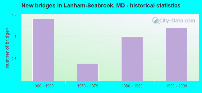
- New bridges - historical statistics
- 71960-1969
- 21970-1979
- 51980-1989
- 61990-1999


- Bridge Condition - Deck
- 22.2%Good
- 44.4%Satisfactory
- 22.2%Fair
- 11.1%Poor

- Bridge Condition - Superstructure
- 11.1%Very good
- 22.2%Good
- 33.3%Satisfactory
- 22.2%Fair
- 11.1%Poor

- Bridge Condition - Substructure
- 22.2%Good
- 55.6%Satisfactory
- 22.2%Fair

- Bridge Condition - Channel
- 11.1%Very good
- 22.2%Good
- 55.6%Satisfactory
- 11.1%Fair

- Bridge Condition - Culverts
- 33.3%Good
- 66.7%Satisfactory
Find on map >> Show street view
Structure Number: 10000016011601, Location: 0.07 M N OF EBENEZER LANE (Lat: 38.946269, Lng: -76.854044), Route carried "on" structure: State highway 950A, Year Built: 1993, Status: Open, Structure Length: 9.08m (29.79ft), Average Daily Traffic: 9,110 (year 2009), Truck Traffic: 8%, Average Future Daily Traffic: 10,815 (year 2026), Design Load: H 20, Features Intersected: IS 595, RAMPS H, D & C
Minimum Vertical Clearance: 30+ m (98+ ft), Kilometerpoint: 2.108, Lanes on structure: 4, Lanes under structure: 11, Owner: State Highway Agency, Approaching Roadway Width: 23.2m (76.1ft), Material/Design: Steel continuous, Design/Construction: Stringer/Multi-beam, Number Of Spans In Main Unit: 3, Length of Maximum Span: 36.9m (121.1ft), Curb or Sidewalk Widths: Left: 1.6m (5.2ft), Right: 1.6m (5.2ft), Curb-To-Curb Width: 15.9m (52.2ft), Out-to-Out Width: 19.8m (65.0ft)
Condition: Deck: Good, Superstructure: Good, Substructure: Satisfactory, Operating Rating: 56.7 metric tons, Method Used To Determine Operating Rating: Load Factor (LF), Inventory Rating: 34.0 metric tons, Method Used To Determine Inventory Rating: Load Factor (LF), Structural Evaluation: Equal to present minimum criteria, Deck Geometry: Meets minimum limits, Underclear: Equal to present minimum criteria, Approach Roadway Alignment: Equal to present desirable criteria, Designated Inspection Frequency: Every 24 months, Inspection Date: August 2020, Deck Structure Type: Concrete Cast-file-Place, Wearing Surface/Protective System: Wearing Surface: Monolithic Concrete, Deck Protection: Epoxy Coated Reinforcing
Find on map >> Show street view
Structure Number: 10000016017901, Location: 0.38 MILE EAST OF MD 564 (Lat: 38.964000, Lng: -76.851867), Route carried "on" structure: State highway 450, Year Built: 1968, Year Reconstructed: 2002, Status: Open, Structure Length: 1.29m (4.23ft), Average Daily Traffic: 24,890 (year 2009), Truck Traffic: 5%, Average Future Daily Traffic: 28,283 (year 2026), Design Load: HS 25 or greater, Features Intersected: BALD HILL BRANCH
Minimum Vertical Clearance: 30+ m (98+ ft), Kilometerpoint: 8.898, Lanes on structure: 4, Owner: State Highway Agency, Approaching Roadway Width: 28.7m (94.2ft), Skew: 30 degrees, Material/Design: Prestressed concrete, Design/Construction: Slab, Number Of Spans In Main Unit: 1, Length of Maximum Span: 11.9m (39.0ft), Curb or Sidewalk Widths: Left: 1.6m (5.2ft), Right: 1.6m (5.2ft), Curb-To-Curb Width: 29.3m (96.1ft), Out-to-Out Width: 33.0m (108.3ft)
Condition: Deck: Satisfactory, Superstructure: Satisfactory, Substructure: Satisfactory, Channel: Very good, Operating Rating: 72.6 metric tons, Method Used To Determine Operating Rating: Load Factor (LF), Inventory Rating: 43.5 metric tons, Method Used To Determine Inventory Rating: Load Factor (LF), Structural Evaluation: Equal to present minimum criteria, Deck Geometry: Superior to present desirable criteria, Waterway Adequacy: Superior to present desirable criteria, Approach Roadway Alignment: Equal to present desirable criteria, Designated Inspection Frequency: Every 24 months, Inspection Date: January 2022, Deck Structure Type: Concrete Precast Panels, Wearing Surface/Protective System: Wearing Surface: Integral Concrete, Deck Protection: Epoxy Coated Reinforcing
Find on map >> Show street view
Structure Number: 10000016021002, Location: 0.7 MILE EAST OF MD 450 (Lat: 38.968750, Lng: -76.853342), Route carried "on" structure: State highway 564, Year Built: 1973, Status: Open, Structure Length: 2.29m (7.51ft), Average Daily Traffic: 18,290 (year 2009), Truck Traffic: 8%, Average Future Daily Traffic: 25,401 (year 2026), Design Load: HS 20, Features Intersected: BALD HILL BRANCH
Minimum Vertical Clearance: 30+ m (98+ ft), Kilometerpoint: 1.126, Lanes on structure: 2, Owner: State Highway Agency, Approaching Roadway Width: 13.4m (44.0ft), Skew: 3 degrees, Material/Design: Concrete, Design/Construction: Culvert, Length of Maximum Span: 4.3m (14.1ft)
Condition: Channel: Satisfactory, Culverts: Good, Operating Rating: 32.7 metric tons, Method Used To Determine Operating Rating: Field evaluation and documented engineering judgment, Inventory Rating: 32.7 metric tons, Method Used To Determine Inventory Rating: Field evaluation and documented engineering judgment, Structural Evaluation: Better than present minimum criteria, Waterway Adequacy: Equal to present desirable criteria, Approach Roadway Alignment: Equal to present desirable criteria, Designated Inspection Frequency: Every 24 months, Inspection Date: November 2021
Find on map >> Show street view
Structure Number: 10000016022601, Location: 0.54 MI S OF MD 450 (Lat: 38.952169, Lng: -76.861556), Route carried "on" structure: Ramp Interstate 95, Year Built: 1988, Status: Open, Structure Length: 15.27m (50.10ft), Average Daily Traffic: 3,910 (year 2017), Truck Traffic: 8%, Average Future Daily Traffic: 4,540 (year 2037), Design Load: HS 20, Features Intersected: IS 95,& RPS A,B, COBB RD
Minimum Vertical Clearance: 30+ m (98+ ft), Kilometerpoint: 1.496, Lanes on structure: 1, Lanes under structure: 12, Base Highway Network: Yes, Owner: State Highway Agency, Approaching Roadway Width: 9.1m (29.9ft), Skew: 4 degrees, Material/Design: Steel continuous, Design/Construction: Stringer/Multi-beam, Number Of Spans In Main Unit: 3, Length of Maximum Span: 51.5m (169.0ft), Curb-To-Curb Width: 9.1m (29.9ft), Out-to-Out Width: 10.4m (34.1ft)
Condition: Deck: Satisfactory, Superstructure: Good, Substructure: Satisfactory, Operating Rating: 85.3 metric tons, Method Used To Determine Operating Rating: Load Factor (LF), Inventory Rating: 53.1 metric tons, Method Used To Determine Inventory Rating: Load Factor (LF), Structural Evaluation: Equal to present minimum criteria, Deck Geometry: Superior to present desirable criteria, Underclear: Equal to present minimum criteria, Approach Roadway Alignment: Equal to present desirable criteria, Designated Inspection Frequency: Every 24 months, Other Special Inspection Frequency: Every 24 months, Inspection Date: July 2021, Other Special Inspection Date: August 2020, Deck Structure Type: Concrete Cast-file-Place, Wearing Surface/Protective System: Wearing Surface: Integral Concrete, Membrane: Built-up, Deck Protection: Epoxy Coated Reinforcing
Find on map >> Show street view
Structure Number: 10000016024302, Location: 0.31 MILE EAST OF IS 595 (Lat: 38.949411, Lng: -76.839825), Route carried "on" structure: State highway 704, Year Built: 1992, Status: Open, Structure Length: 1.83m (6.00ft), Average Daily Traffic: 47,791 (year 2012), Truck Traffic: 8%, Average Future Daily Traffic: 64,518 (year 2032), Design Load: HS 20, Features Intersected: BALD HILL BRANCH
Minimum Vertical Clearance: 30+ m (98+ ft), Kilometerpoint: 8.801, Lanes on structure: 5, Base Highway Network: Yes, Owner: State Highway Agency, Approaching Roadway Width: 30.5m (100.1ft), Skew: 4 degrees, Material/Design: Concrete, Design/Construction: Culvert, Length of Maximum Span: 4.0m (13.1ft), Curb or Sidewalk Widths: Left: 1.5m (4.9ft), Right: 0.0m
Condition: Channel: Good, Culverts: Satisfactory, Operating Rating: 32.7 metric tons, Method Used To Determine Operating Rating: Field evaluation and documented engineering judgment, Inventory Rating: 32.7 metric tons, Method Used To Determine Inventory Rating: Field evaluation and documented engineering judgment, Structural Evaluation: Equal to present minimum criteria, Waterway Adequacy: Equal to present desirable criteria, Approach Roadway Alignment: Equal to present desirable criteria, Designated Inspection Frequency: Every 24 months, Underwater Inspection Frequency: Every 48 months, Inspection Date: December 2021, Underwater Inspection Date: December 2019
Find on map >> Show street view
Structure Number: 200000P-010504, Location: 0.09 MI E CIPRIANO RD (Lat: 38.978031, Lng: -76.853456), Route carried "on" structure: County highway 42, Year Built: 1963, Status: Posted for load, Structure Length: 1.19m (3.90ft), Average Daily Traffic: 14,199 (year 2018), Truck Traffic: 5%, Average Future Daily Traffic: 21,099 (year 2038), Features Intersected: BALD HILL BRANCH, Facility Carried by Structure: GOOD LUCK ROAD
Minimum Vertical Clearance: 30+ m (98+ ft), Kilometerpoint: 5.760, Lanes on structure: 2, Owner: County Highway Agency, Approaching Roadway Width: 13.4m (44.0ft), Skew: 2 degrees, Material/Design: Concrete continuous, Design/Construction: Frame, Number Of Spans In Main Unit: 2, Length of Maximum Span: 5.8m (19.0ft), Curb or Sidewalk Widths: Left: 1.1m (3.6ft), Right: 0.9m (3.0ft), Curb-To-Curb Width: 13.4m (44.0ft), Out-to-Out Width: 16.0m (52.5ft)
Condition: Deck: Fair, Superstructure: Fair, Substructure: Satisfactory, Channel: Fair, Operating Rating: 55.8 metric tons, Method Used To Determine Operating Rating: Load Factor (LF), Inventory Rating: 33.6 metric tons, Method Used To Determine Inventory Rating: Load Factor (LF), Structural Evaluation: Somewhat better than minimum adequacy, Deck Geometry: Equal to present minimum criteria, Waterway Adequacy: Somewhat better than minimum adequacy, Approach Roadway Alignment: Equal to present desirable criteria, Bridge Posting: Required (Relationship of Operating Rating to Maximum Legal Load: 20.0 - 29.9% below), Length Of Structure Improvement: 1.19m (3.90ft), Designated Inspection Frequency: Every 24 months, Inspection Date: March 2020, Deck Structure Type: Concrete Cast-file-Place, Wearing Surface/Protective System: Wearing Surface: Bituminous
Find on map >> Show street view
Structure Number: 200000P-027101, Location: 0.22 MI NE OF MD 450 (Lat: 38.966117, Lng: -76.852975), Route carried "on" structure: County highway 4148, Year Built: 1967, Status: Open, Structure Length: 1.13m (3.71ft), Average Daily Traffic: 5,960 (year 2019), Truck Traffic: 10%, Average Future Daily Traffic: 9,115 (year 2039), Design Load: HS 20, Features Intersected: BALD HILL BRANCH, Facility Carried by Structure: GREENWOOD LANE
Minimum Vertical Clearance: 30+ m (98+ ft), Kilometerpoint: 0.354, Lanes on structure: 2, Owner: County Highway Agency, Approaching Roadway Width: 9.1m (29.9ft), Material/Design: Prestressed concrete, Design/Construction: Box Beam or Girders - Multiple, Number Of Spans In Main Unit: 1, Length of Maximum Span: 10.4m (34.1ft), Curb or Sidewalk Widths: Left: 1.2m (3.9ft), Right: 1.2m (3.9ft), Curb-To-Curb Width: 7.9m (25.9ft), Out-to-Out Width: 11.0m (36.1ft)
Condition: Deck: Satisfactory, Superstructure: Satisfactory, Substructure: Good, Channel: Satisfactory, Operating Rating: 74.8 metric tons, Method Used To Determine Operating Rating: Load Factor (LF), Inventory Rating: 44.9 metric tons, Method Used To Determine Inventory Rating: Load Factor (LF), Structural Evaluation: Equal to present minimum criteria, Deck Geometry: High priority of replacement, Waterway Adequacy: Better than present minimum criteria, Approach Roadway Alignment: Equal to present desirable criteria, Length Of Structure Improvement: 1.52m (4.99ft), Designated Inspection Frequency: Every 24 months, Inspection Date: March 2021, Bridge Improvement Cost: $204,000, Roadway Improvement Cost: $20,000, Total Project Cost: $224,000, Deck Structure Type: Other, Wearing Surface/Protective System: Wearing Surface: Bituminous
Find on map >> Show street view
Structure Number: 200000P-027301, Location: 0.05 MI SOUTH OF MD 564 (Lat: 38.970219, Lng: -76.848292), Route carried "on" structure: County highway 1043, Year Built: 1979, Status: Open, Structure Length: 6.46m (21.19ft), Average Daily Traffic: 15,218 (year 2019), Truck Traffic: 10%, Average Future Daily Traffic: 22,615 (year 2039), Design Load: HS 20, Features Intersected: AMTRAK RAILROAD, Facility Carried by Structure: CARTER AVENUE
Minimum Vertical Clearance: 30+ m (98+ ft), Kilometerpoint: 0.595, Lanes on structure: 4, Owner: County Highway Agency, Approaching Roadway Width: 13.4m (44.0ft), Material/Design: Steel continuous, Design/Construction: Stringer/Multi-beam, Number Of Spans In Main Unit: 3, Length of Maximum Span: 26.8m (87.9ft), Curb or Sidewalk Widths: Left: 1.5m (4.9ft), Right: 1.5m (4.9ft), Curb-To-Curb Width: 13.4m (44.0ft), Out-to-Out Width: 17.1m (56.1ft)
Condition: Deck: Satisfactory, Superstructure: Satisfactory, Substructure: Satisfactory, Operating Rating: 63.0 metric tons, Method Used To Determine Operating Rating: Load Factor (LF), Inventory Rating: 37.6 metric tons, Method Used To Determine Inventory Rating: Load Factor (LF), Structural Evaluation: Equal to present minimum criteria, Deck Geometry: High priority of replacement, Underclear: Equal to present desirable criteria, Approach Roadway Alignment: Equal to present minimum criteria, Length Of Structure Improvement: 7.62m (25.00ft), Designated Inspection Frequency: Every 24 months, Inspection Date: January 2021, Bridge Improvement Cost: $204,000, Roadway Improvement Cost: $51,000, Total Project Cost: $255,000, Deck Structure Type: Concrete Cast-file-Place, Wearing Surface/Protective System: Wearing Surface: Integral Concrete, Deck Protection: Epoxy Coated Reinforcing
Find on map >> Show street view
Structure Number: 200000P-029501, Location: 0.04 MI W OF ELLERBIE ST (Lat: 38.957656, Lng: -76.848094), Route carried "on" structure: County highway 1897, Year Built: 1967, Status: Posted for load, Structure Length: 2.01m (6.59ft), Average Daily Traffic: 758 (year 2017), Truck Traffic: 10%, Average Future Daily Traffic: 1,130 (year 2037), Design Load: H 20, Features Intersected: BALD HILL BRANCH, Facility Carried by Structure: ALCONA STREET
Minimum Vertical Clearance: 30+ m (98+ ft), Kilometerpoint: 0.917, Lanes on structure: 2, Owner: County Highway Agency, Approaching Roadway Width: 7.9m (25.9ft), Material/Design: Prestressed concrete, Design/Construction: Stringer/Multi-beam, Number Of Spans In Main Unit: 2, Length of Maximum Span: 10.1m (33.1ft), Curb or Sidewalk Widths: Left: 1.2m (3.9ft), Right: 1.2m (3.9ft), Curb-To-Curb Width: 7.9m (25.9ft), Out-to-Out Width: 11.0m (36.1ft)
Condition: Deck: Poor, Superstructure: Poor, Substructure: Fair, Channel: Satisfactory, Operating Rating: 72.1 metric tons, Method Used To Determine Operating Rating: Load Factor (LF), Inventory Rating: 26.8 metric tons, Method Used To Determine Inventory Rating: Load Factor (LF), Structural Evaluation: Meets minimum limits, Deck Geometry: Somewhat better than minimum adequacy, Waterway Adequacy: Better than present minimum criteria, Approach Roadway Alignment: Equal to present desirable criteria, Length Of Structure Improvement: 2.01m (6.59ft), Designated Inspection Frequency: Every 12 months, Inspection Date: March 2021, Deck Structure Type: Concrete Precast Panels, Wearing Surface/Protective System: Wearing Surface: Bituminous
Find on map >> Show street view
Structure Number: 200000P-029601, Location: 0.29 MI N OF MD 450 (Lat: 38.962156, Lng: -76.823211), Route carried "on" structure: County highway 412, Year Built: 1998, Status: Open, Structure Length: 1.71m (5.61ft), Average Daily Traffic: 951 (year 2021), Truck Traffic: 10%, Average Future Daily Traffic: 1,378 (year 2041), Design Load: HS 20, Features Intersected: FOLLY BRANCH, Facility Carried by Structure: BALTIMORE LANE
Minimum Vertical Clearance: 30+ m (98+ ft), Kilometerpoint: 0.467, Lanes on structure: 2, Owner: County Highway Agency, Approaching Roadway Width: 10.4m (34.1ft), Material/Design: Prestressed concrete, Design/Construction: Box Beam or Girders - Multiple, Number Of Spans In Main Unit: 1, Length of Maximum Span: 15.9m (52.2ft), Curb-To-Curb Width: 10.5m (34.4ft), Out-to-Out Width: 11.5m (37.7ft)
Condition: Deck: Good, Superstructure: Very good, Substructure: Good, Channel: Good, Operating Rating: 83.0 metric tons, Method Used To Determine Operating Rating: Load Factor (LF), Inventory Rating: 46.3 metric tons, Method Used To Determine Inventory Rating: Load Factor (LF), Structural Evaluation: Better than present minimum criteria, Deck Geometry: Equal to present minimum criteria, Waterway Adequacy: Better than present minimum criteria, Approach Roadway Alignment: Equal to present desirable criteria, Designated Inspection Frequency: Every 24 months, Inspection Date: March 2021, Deck Structure Type: Concrete Precast Panels, Wearing Surface/Protective System: Wearing Surface: Monolithic Concrete
Find on map >> Show street view
Structure Number: 200000P-029802, Location: 0.12 MI W OF MAIN STREET (Lat: 38.972119, Lng: -76.853336), Route carried "on" structure: County highway 44, Year Built: 1964, Status: Posted for load, Structure Length: 1.16m (3.81ft), Average Daily Traffic: 540 (year 2017), Truck Traffic: 10%, Average Future Daily Traffic: 800 (year 2037), Design Load: HS 20, Features Intersected: BALD HILL BRANCH, Facility Carried by Structure: 4 TH STREET
Minimum Vertical Clearance: 30+ m (98+ ft), Kilometerpoint: 0.515, Lanes on structure: 2, Owner: County Highway Agency, Approaching Roadway Width: 9.1m (29.9ft), Material/Design: Concrete, Design/Construction: Culvert, Number Of Spans In Main Unit: 3, Length of Maximum Span: 3.7m (12.1ft), Curb or Sidewalk Widths: Left: 1.2m (3.9ft), Right: 1.2m (3.9ft), Curb-To-Curb Width: 9.1m (29.9ft), Out-to-Out Width: 12.2m (40.0ft)
Condition: Channel: Satisfactory, Culverts: Satisfactory, Operating Rating: 39.0 metric tons, Method Used To Determine Operating Rating: Load Factor (LF), Inventory Rating: 22.7 metric tons, Method Used To Determine Inventory Rating: Load Factor (LF), Structural Evaluation: Equal to present minimum criteria, Deck Geometry: Equal to present minimum criteria, Waterway Adequacy: Equal to present minimum criteria, Approach Roadway Alignment: Equal to present desirable criteria, Designated Inspection Frequency: Every 24 months, Inspection Date: January 2021
Find on map >> Show street view
Structure Number: 200000P-029901, Location: 0.02 MI E OF CIPRIANO RD (Lat: 38.977078, Lng: -76.854400), Route carried "on" structure: County highway 1129, Year Built: 1963, Status: Open, Structure Length: 1.52m (4.99ft), Average Daily Traffic: 3,523 (year 2019), Truck Traffic: 10%, Average Future Daily Traffic: 5,235 (year 2039), Design Load: H 20, Features Intersected: BALD HILL BRANCH, Facility Carried by Structure: TUCKERMAN STREET
Minimum Vertical Clearance: 30+ m (98+ ft), Kilometerpoint: 0.032, Lanes on structure: 2, Owner: County Highway Agency, Approaching Roadway Width: 11.0m (36.1ft), Material/Design: Prestressed concrete, Design/Construction: Box Beam or Girders - Multiple, Number Of Spans In Main Unit: 2, Length of Maximum Span: 7.0m (23.0ft), Curb or Sidewalk Widths: Left: 1.2m (3.9ft), Right: 1.2m (3.9ft), Curb-To-Curb Width: 11.0m (36.1ft), Out-to-Out Width: 14.0m (45.9ft)
Condition: Deck: Fair, Superstructure: Fair, Substructure: Fair, Channel: Satisfactory, Operating Rating: 78.0 metric tons, Method Used To Determine Operating Rating: Load Factor (LF), Inventory Rating: 46.7 metric tons, Method Used To Determine Inventory Rating: Load Factor (LF), Structural Evaluation: Somewhat better than minimum adequacy, Deck Geometry: Somewhat better than minimum adequacy, Waterway Adequacy: Equal to present minimum criteria, Approach Roadway Alignment: Equal to present desirable criteria, Length Of Structure Improvement: 1.52m (4.99ft), Designated Inspection Frequency: Every 24 months, Inspection Date: Febuary 2021, Wearing Surface/Protective System: Wearing Surface: Bituminous
Find on map >> Show street view
Structure Number: 10000016011601, Location: 0.5 MILE WEST OF MD 704 (Lat: 38.946269, Lng: -76.854044), Route carried "under" structure: Interstate 595, Year Built: 1961, Structure Length: 0. m, Average Daily Traffic: 153,970 (year 2009), Truck Traffic: 8%, Features Intersected: IS 595, Facility Carried by Structure: MD 950A
Minimum Vertical Clearance: 5.18m (16.99ft), Kilometerpoint: 0.837, Lanes on structure: 4, Lanes under structure: 8, Material/Design: Steel continuous, Design/Construction: Stringer/Multi-beam, Length of Maximum Span: 21.0m (68.9ft)
Find on map >> Show street view
Structure Number: 10000016011601, Location: IS 95 NBR TO IS 595 EBR (Lat: 38.946269, Lng: -76.854044), Route carried "under" structure: Ramp Interstate 595, Year Built: 1993, Structure Length: 0. m, Average Daily Traffic: 20,366 (year 2006), Truck Traffic: 8%, Features Intersected: RAMP 'H' (4), Facility Carried by Structure: MD 950A
Minimum Vertical Clearance: 5.49m (18.01ft), Kilometerpoint: 0.837, Lanes on structure: 4, Lanes under structure: 1, Material/Design: Steel continuous, Design/Construction: Stringer/Multi-beam, Length of Maximum Span: 36.9m (121.1ft)
Find on map >> Show street view
Structure Number: 10000016011601, Location: IS 595 EBR TO IS 95 SBR (Lat: 38.946269, Lng: -76.854044), Route carried "under" structure: Ramp Interstate 595, Year Built: 1993, Structure Length: 0. m, Average Daily Traffic: 22,154 (year 2006), Truck Traffic: 8%, Features Intersected: RAMP 'D' (7), Facility Carried by Structure: MD 950A
Minimum Vertical Clearance: 5.49m (18.01ft), Kilometerpoint: 0.837, Lanes on structure: 4, Lanes under structure: 1, Material/Design: Steel continuous, Design/Construction: Stringer/Multi-beam, Length of Maximum Span: 36.9m (121.1ft)
Find on map >> Show street view
Structure Number: 10000016011601, Location: IS 595 EBR TO IS 95 NBR (Lat: 38.946269, Lng: -76.854044), Route carried "under" structure: Ramp Interstate 595, Year Built: 1993, Structure Length: 0. m, Average Daily Traffic: 27,176 (year 2006), Truck Traffic: 8%, Features Intersected: RAMP 'D' (2), Facility Carried by Structure: MD 950A
Minimum Vertical Clearance: 5.79m (19.00ft), Kilometerpoint: 0.837, Lanes on structure: 4, Lanes under structure: 1, Material/Design: Steel continuous, Design/Construction: Stringer/Multi-beam, Length of Maximum Span: 36.9m (121.1ft)
Find on map >> Show street view
Structure Number: 10000016022601, Location: 0.51 MILE NORTH OF IS 595 (Lat: 38.952100, Lng: -76.861547), Route carried "under" structure: Interstate 95, Year Built: 1988, Structure Length: 0. m, Average Daily Traffic: 230,880 (year 2009), Truck Traffic: 8%, Features Intersected: IS 95
Minimum Vertical Clearance: 6.40m (21.00ft), Kilometerpoint: 30.651, Lanes on structure: 1, Lanes under structure: 8, Material/Design: Steel continuous, Design/Construction: Stringer/Multi-beam, Length of Maximum Span: 51.5m (169.0ft)
Find on map >> Show street view
Structure Number: 10000016022601, Location: 0.51 MILE NORTH OF IS 595 (Lat: 38.952100, Lng: -76.861547), Route carried "under" structure: Ramp Interstate 95, Year Built: 1988, Structure Length: 0. m, Average Daily Traffic: 26,566 (year 2006), Truck Traffic: 8%, Features Intersected: IS RAMP A(5)
Minimum Vertical Clearance: 5.49m (18.01ft), Kilometerpoint: 30.651, Lanes on structure: 1, Lanes under structure: 1, Material/Design: Steel continuous, Design/Construction: Stringer/Multi-beam, Length of Maximum Span: 51.5m (169.0ft)
Find on map >> Show street view
Structure Number: 10000016022601, Location: 0.51 MILE NORTH OF IS 595 (Lat: 38.952100, Lng: -76.861547), Route carried "under" structure: Ramp Interstate 95, Year Built: 1988, Structure Length: 0. m, Average Daily Traffic: 11,648 (year 2006), Truck Traffic: 8%, Features Intersected: IS 95 RAMP B(3)
Minimum Vertical Clearance: 6.40m (21.00ft), Kilometerpoint: 30.651, Lanes on structure: 1, Lanes under structure: 1, Material/Design: Steel continuous, Design/Construction: Stringer/Multi-beam, Length of Maximum Span: 51.5m (169.0ft)
Find on map >> Show street view
Structure Number: 10000016022601, Location: 0.04 M N OF CORPORATE RD (Lat: 38.952100, Lng: -76.861547), Route carried "under" structure: County highway 3137, Year Built: 1988, Structure Length: 0. m, Features Intersected: COBB ROAD, Facility Carried by Structure: IS 595 RAMP 'C'(9)
Minimum Vertical Clearance: 6.40m (21.00ft), Kilometerpoint: 0.064, Lanes on structure: 1, Lanes under structure: 2, Material/Design: Steel continuous, Design/Construction: Stringer/Multi-beam, Length of Maximum Span: 51.5m (169.0ft)