Bridge Statistics for Landisville, Pennsylvania (PA)
Condition, Traffic, Stress, Structural Evaluation, Project Costs
- National Bridge Inventory (NBI) Statistics
- 10Number of bridges
- 49ft / 15.2mTotal length
- $216,000Total costs
- 150,965Total average daily traffic
- 19,051Total average daily truck traffic
- National Bridge Inventory (NBI) Registered Bridges for Landisville
- No street view available for this location
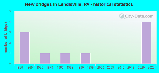
- New bridges - historical statistics
- 31960-1969
- 11970-1979
- 11980-1989
- 11990-1999
- 42020-2022


- Bridge Condition - Deck
- 25.0%Excellent
- 75.0%Good

- Bridge Condition - Superstructure
- 40.0%Excellent
- 20.0%Good
- 40.0%Fair

- Bridge Condition - Substructure
- 40.0%Excellent
- 40.0%Good
- 20.0%Satisfactory

- Bridge Condition - Channel
- 25.0%Very good
- 50.0%Good
- 25.0%Satisfactory
Find on map >> Show street view
Structure Number: 21186, Location: LANDISVILLE (Lat: 40.098569, Lng: -76.410725), Route carried "on" structure: State highway , Year Built: 1969, Year Reconstructed: 2009, Status: Open, Structure Length: 3.87m (12.70ft), Average Daily Traffic: 4,392 (year 2022), Truck Traffic: 4%, Average Future Daily Traffic: 2,161 (year 2032), Design Load: HS 20, Features Intersected: PA 283; SR 0300, Facility Carried by Structure: SR 4049;L-ville rd
Minimum Vertical Clearance: 30+ m (98+ ft), Kilometerpoint: 0.000, Lanes on structure: 2, Lanes under structure: 4, Owner: State Highway Agency, Approaching Roadway Width: 9.1m (29.9ft), Skew: 2 degrees, Material/Design: Steel, Design/Construction: Stringer/Multi-beam, Number Of Spans In Main Unit: 1, Number Of Approach Spans: 2, Length of Maximum Span: 23.5m (77.1ft), Curb or Sidewalk Widths: Left: 0.0m, Right: 1.4m (4.6ft), Curb-To-Curb Width: 9.1m (29.9ft), Out-to-Out Width: 11.6m (38.1ft)
Condition: Deck: Good, Superstructure: Fair, Substructure: Satisfactory, Operating Rating: 46.3 metric tons, Method Used To Determine Operating Rating: Load Factor (LF), Inventory Rating: 27.2 metric tons, Method Used To Determine Inventory Rating: Load Factor (LF), Structural Evaluation: Somewhat better than minimum adequacy, Deck Geometry: Meets minimum limits, Underclear: Equal to present minimum criteria, Approach Roadway Alignment: Equal to present desirable criteria, Length Of Structure Improvement: 4.70m (15.42ft), Designated Inspection Frequency: Every 24 months, Inspection Date: October 2020, Bridge Improvement Cost: $16,000, Roadway Improvement Cost: $47,000, Total Project Cost: $216,000, Deck Structure Type: Concrete Cast-file-Place, Wearing Surface/Protective System: Wearing Surface: Monolithic Concrete
Find on map >> Show street view
Structure Number: 21918, Location: 3/4 MILE NW OF T-711 (Lat: 40.122172, Lng: -76.405175), Route carried "on" structure: City street , Year Built: 1970, Year Reconstructed: 2012, Status: Open, Structure Length: 4.63m (15.19ft), Average Daily Traffic: 1,140 (year 2012), Average Future Daily Traffic: 1,530 (year 2032), Design Load: HL 93, Features Intersected: CHIQUES CREEK, Facility Carried by Structure: COLEBROOK RD
Minimum Vertical Clearance: 30+ m (98+ ft), Kilometerpoint: 0.000, Lanes on structure: 2, Owner: County Highway Agency, Approaching Roadway Width: 7.3m (24.0ft), Skew: 3 degrees, Material/Design: Prestressed concrete, Design/Construction: Box Beam or Girders - Multiple, Number Of Spans In Main Unit: 2, Length of Maximum Span: 23.5m (77.1ft), Curb or Sidewalk Widths: Left: 0.2m (0.7ft), Right: 0.2m (0.7ft), Curb-To-Curb Width: 8.8m (28.9ft), Out-to-Out Width: 9.8m (32.2ft)
Condition: Deck: Good, Superstructure: Fair, Substructure: Good, Channel: Satisfactory, Operating Rating: 49.0 metric tons, Method Used To Determine Operating Rating: Load and Resistance Factor (LRFR), Inventory Rating: 16.3 metric tons, Method Used To Determine Inventory Rating: Load and Resistance Factor (LRFR), Structural Evaluation: Meets minimum limits, Deck Geometry: Somewhat better than minimum adequacy, Waterway Adequacy: Equal to present desirable criteria, Approach Roadway Alignment: Better than present minimum criteria, Length Of Structure Improvement: 5.50m (18.04ft), Designated Inspection Frequency: Every 24 months, Inspection Date: May 2020, Deck Structure Type: Concrete Cast-file-Place, Wearing Surface/Protective System: Wearing Surface: Monolithic Concrete
Find on map >> Show street view
Structure Number: 4271, Location: CHURCH ST. LANDISVILLE (Lat: 40.083278, Lng: -76.409078), Route carried "on" structure: State highway , Year Built: 1999, Status: Open, Structure Length: 0.73m (2.40ft), Average Daily Traffic: 6,026 (year 2020), Truck Traffic: 2%, Average Future Daily Traffic: 10,176 (year 2032), Design Load: HS 25 or greater, Features Intersected: SWARR RUN, Facility Carried by Structure: SR 3017
Minimum Vertical Clearance: 30+ m (98+ ft), Kilometerpoint: 30.092, Lanes on structure: 2, Owner: State Highway Agency, Approaching Roadway Width: 11.0m (36.1ft), Skew: 2 degrees, Material/Design: Concrete, Design/Construction: Frame, Number Of Spans In Main Unit: 1, Length of Maximum Span: 6.7m (22.0ft), Curb-To-Curb Width: 10.9m (35.8ft), Out-to-Out Width: 12.1m (39.7ft)
Condition: Deck: Good, Superstructure: Good, Substructure: Good, Channel: Good, Operating Rating: 89.8 metric tons, Method Used To Determine Operating Rating: Load Factor (LF), Inventory Rating: 55.3 metric tons, Method Used To Determine Inventory Rating: Load Factor (LF), Structural Evaluation: Better than present minimum criteria, Deck Geometry: Meets minimum limits, Waterway Adequacy: Better than present minimum criteria, Approach Roadway Alignment: Equal to present desirable criteria, Length Of Structure Improvement: 1.40m (4.59ft), Designated Inspection Frequency: Every 24 months, Inspection Date: October 2020, Deck Structure Type: Concrete Cast-file-Place, Wearing Surface/Protective System: Wearing Surface: Monolithic Concrete, Deck Protection: Epoxy Coated Reinforcing
Find on map >> Show street view
Structure Number: 57573, Location: 300 FT W. OF KINGSWAY DR. (Lat: 40.068144, Lng: -76.406522), Route carried "on" structure: City street , Year Built: 1985, Status: Open, Structure Length: 0.82m (2.69ft), Average Daily Traffic: 300 (year 2020), Average Future Daily Traffic: 350 (year 2040), Features Intersected: TRIBUTARY SWARR RUN, Facility Carried by Structure: INDIAN SPRING DR
Minimum Vertical Clearance: 30+ m (98+ ft), Kilometerpoint: 0.000, Lanes on structure: 2, Owner: Town or Township Highway Agency, Approaching Roadway Width: 10.7m (35.1ft), Skew: 1 degrees, Material/Design: Concrete, Design/Construction: Culvert, Number Of Spans In Main Unit: 2, Length of Maximum Span: 3.7m (12.1ft), Curb or Sidewalk Widths: Left: 3.7m (12.1ft), Right: 3.8m (12.5ft), Curb-To-Curb Width: 10.7m (35.1ft), Out-to-Out Width: 19.6m (64.3ft)
Condition: Channel: Good, Culverts: Good, Operating Rating: 59.9 metric tons, Method Used To Determine Operating Rating: Field evaluation and documented engineering judgment, Inventory Rating: 35.4 metric tons, Method Used To Determine Inventory Rating: Field evaluation and documented engineering judgment, Structural Evaluation: Better than present minimum criteria, Deck Geometry: Better than present minimum criteria, Waterway Adequacy: Equal to present desirable criteria, Approach Roadway Alignment: Equal to present desirable criteria, Designated Inspection Frequency: Every 24 months, Inspection Date: May 2020, Wearing Surface/Protective System: Wearing Surface: Bituminous
Find on map >> Show street view
Structure Number: 67571, Location: 1.5 mi.S.W. E.Petersburg (Lat: 40.088861, Lng: -76.380539), Route carried "on" structure: State highway 722, Year Built: 2020, Status: Open, Structure Length: 3.63m (11.91ft), Average Daily Traffic: 12,682 (year 2022), Truck Traffic: 3%, Average Future Daily Traffic: 17,240 (year 2040), Design Load: HL 93, Features Intersected: PA 283; SR 0300
Minimum Vertical Clearance: 30+ m (98+ ft), Kilometerpoint: 0.000, Lanes on structure: 4, Lanes under structure: 4, Owner: State Highway Agency, Approaching Roadway Width: 23.8m (78.1ft), Skew: 2 degrees, Material/Design: Prestressed concrete, Design/Construction: Stringer/Multi-beam, Number Of Spans In Main Unit: 1, Length of Maximum Span: 35.1m (115.2ft), Curb or Sidewalk Widths: Left: 0.1m (0.3ft), Right: 0.1m (0.3ft), Curb-To-Curb Width: 23.8m (78.1ft), Out-to-Out Width: 24.8m (81.4ft)
Condition: Deck: Excellent, Superstructure: Excellent, Substructure: Excellent, Operating Rating: 55.1 metric tons, Method Used To Determine Operating Rating: Assigned ratings based on Load and Resistance Factor Design (LRFD) reported by rating factor (RF) using HL93 loadings, Inventory Rating: 38.9 metric tons, Method Used To Determine Inventory Rating: Assigned ratings based on Load and Resistance Factor Design (LRFD) reported by rating factor (RF) using HL93 loadings, Structural Evaluation: Superior to present desirable criteria, Deck Geometry: Superior to present desirable criteria, Underclear: High priority of corrective action, Approach Roadway Alignment: Equal to present desirable criteria, Designated Inspection Frequency: Every 24 months, Inspection Date: November 2020, Deck Structure Type: Concrete Cast-file-Place, Wearing Surface/Protective System: Wearing Surface: Monolithic Concrete, Deck Protection: Epoxy Coated Reinforcing
Find on map >> Show street view
Structure Number: 68614, Location: 1200' NORTH OF SR 4020 (Lat: 40.083228, Lng: -76.381458), Route carried "on" structure: City street , Year Built: 2021, Status: Open, Structure Length: 1.55m (5.09ft), Average Daily Traffic: 5,300 (year 2021), Truck Traffic: 5%, Average Future Daily Traffic: 6,467 (year 2041), Design Load: HL 93, Features Intersected: Swarr Run, Facility Carried by Structure: T-615 STATE RD
Minimum Vertical Clearance: 30+ m (98+ ft), Kilometerpoint: 0.000, Lanes on structure: 2, Owner: Town or Township Highway Agency, Approaching Roadway Width: 23.2m (76.1ft), Material/Design: Concrete, Design/Construction: Arch - Deck, Number Of Spans In Main Unit: 1, Length of Maximum Span: 14.6m (47.9ft), Curb or Sidewalk Widths: Left: 1.8m (5.9ft), Right: 1.8m (5.9ft), Curb-To-Curb Width: 23.3m (76.4ft), Out-to-Out Width: 29.8m (97.8ft)
Condition: Superstructure: Excellent, Substructure: Excellent, Channel: Very good, Operating Rating: 48.6 metric tons, Method Used To Determine Operating Rating: Assigned ratings based on Load and Resistance Factor Design (LRFD) reported by rating factor (RF) using HL93 loadings, Inventory Rating: 38.9 metric tons, Method Used To Determine Inventory Rating: Assigned ratings based on Load and Resistance Factor Design (LRFD) reported by rating factor (RF) using HL93 loadings, Structural Evaluation: Superior to present desirable criteria, Deck Geometry: Superior to present desirable criteria, Waterway Adequacy: Equal to present desirable criteria, Approach Roadway Alignment: Equal to present desirable criteria, Designated Inspection Frequency: Every 24 months, Inspection Date: October 2021
Find on map >> Show street view
Structure Number: 21186, Location: LANDISVILLE (Lat: 40.098569, Lng: -76.410725), Route carried "under" structure: State highway 283, Year Built: 1969, Structure Length: 0. m, Average Daily Traffic: 31,977 (year 2022), Truck Traffic: 14%, Features Intersected: PA 283; SR 0300, Facility Carried by Structure: SR 4049;L-ville rd
Minimum Vertical Clearance: 5.03m (16.50ft), Kilometerpoint: 20.217, Lanes on structure: 2, Lanes under structure: 2, Material/Design: Steel, Design/Construction: Stringer/Multi-beam, Length of Maximum Span: 23.5m (77.1ft)
Find on map >> Show street view
Structure Number: 21186, Location: LANDISVILLE (Lat: 40.098569, Lng: -76.410725), Route carried "under" structure: State highway 283, Year Built: 1969, Structure Length: 0. m, Average Daily Traffic: 29,174 (year 2022), Truck Traffic: 16%, Features Intersected: PA 283; SR 0300, Facility Carried by Structure: SR 4049;L-ville rd
Minimum Vertical Clearance: 5.03m (16.50ft), Kilometerpoint: 20.191, Lanes on structure: 2, Lanes under structure: 2, Material/Design: Steel, Design/Construction: Stringer/Multi-beam, Length of Maximum Span: 23.5m (77.1ft)
Find on map >> Show street view
Structure Number: 67571, Location: 1.5 mi.S.W. E.Petersburg (Lat: 40.088861, Lng: -76.380539), Route carried "under" structure: State highway 283, Year Built: 2020, Structure Length: 0. m, Average Daily Traffic: 31,319 (year 2022), Truck Traffic: 14%, Features Intersected: PA 283; SR 0300, Facility Carried by Structure: PA 722; State Rd
Minimum Vertical Clearance: 5.05m (16.57ft), Kilometerpoint: 23.447, Lanes on structure: 4, Lanes under structure: 2, Material/Design: Prestressed concrete, Design/Construction: Stringer/Multi-beam, Length of Maximum Span: 35.1m (115.2ft)
Find on map >> Show street view
Structure Number: 67571, Location: 1.5 mi.S.W. E.Petersburg (Lat: 40.088861, Lng: -76.380539), Route carried "under" structure: State highway 283, Year Built: 2020, Structure Length: 0. m, Average Daily Traffic: 28,655 (year 2022), Truck Traffic: 16%, Features Intersected: PA 283; SR 0300, Facility Carried by Structure: PA 722; State Rd
Minimum Vertical Clearance: 5.05m (16.57ft), Kilometerpoint: 23.419, Lanes on structure: 4, Lanes under structure: 2, Material/Design: Prestressed concrete, Design/Construction: Stringer/Multi-beam, Length of Maximum Span: 35.1m (115.2ft)