Bridge Statistics for Lancaster, New York (NY)
Condition, Traffic, Stress, Structural Evaluation, Project Costs
- National Bridge Inventory (NBI) Statistics
- 20Number of bridges
- 112ft / 34.1mTotal length
- $31,581,000Total costs
- 143,931Total average daily traffic
- 3,474Total average daily truck traffic
- National Bridge Inventory (NBI) Registered Bridges for Lancaster
- No street view available for this location
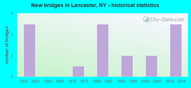
- New bridges - historical statistics
- 51950-1959
- 11970-1979
- 51980-1989
- 21990-1999
- 22000-2009
- 52010-2019
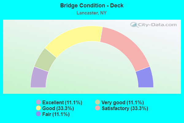
- Bridge Condition - Deck
- 11.1%Excellent
- 11.1%Very good
- 33.3%Good
- 33.3%Satisfactory
- 11.1%Fair
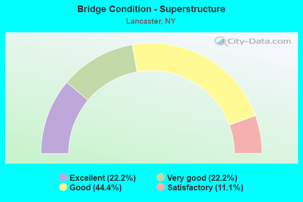
- Bridge Condition - Superstructure
- 22.2%Excellent
- 22.2%Very good
- 44.4%Good
- 11.1%Satisfactory
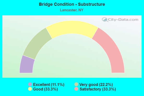
- Bridge Condition - Substructure
- 11.1%Excellent
- 22.2%Very good
- 33.3%Good
- 33.3%Satisfactory
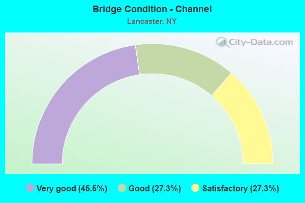
- Bridge Condition - Channel
- 45.5%Very good
- 27.3%Good
- 27.3%Satisfactory
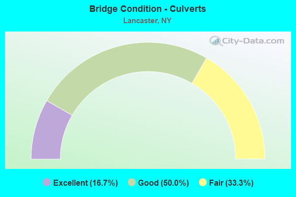
- Bridge Condition - Culverts
- 16.7%Excellent
- 50.0%Good
- 33.3%Fair
Find on map >> Show street view
Structure Number: 101558, Location: 1.3 MI E JCT US20 & NY130 (Lat: 42.899650, Lng: -78.672958), Route carried "on" structure: US 20, Year Built: 2002, Status: Open, Structure Length: 3.72m (12.20ft), Average Daily Traffic: 12,882 (year 2018), Truck Traffic: 5%, Average Future Daily Traffic: 12,942 (year 2040), Design Load: HS 25 or greater, Features Intersected: CAYUGA CREEK
Minimum Vertical Clearance: 30+ m (98+ ft), Kilometerpoint: 56.106, Lanes on structure: 4, Base Highway Network: Yes, Owner: State Highway Agency, Approaching Roadway Width: 14.9m (48.9ft), Skew: 1 degrees, Material/Design: Steel, Design/Construction: Stringer/Multi-beam, Number Of Spans In Main Unit: 1, Length of Maximum Span: 35.6m (116.8ft), Curb or Sidewalk Widths: Left: 1.5m (4.9ft), Right: 1.5m (4.9ft), Curb-To-Curb Width: 15.0m (49.2ft), Out-to-Out Width: 18.7m (61.4ft)
Condition: Deck: Good, Superstructure: Very good, Substructure: Good, Channel: Very good, Operating Rating: 61.1 metric tons, Method Used To Determine Operating Rating: Load Factor (LF), Inventory Rating: 36.6 metric tons, Method Used To Determine Inventory Rating: Load Factor (LF), Structural Evaluation: Better than present minimum criteria, Deck Geometry: High priority of replacement, Waterway Adequacy: Equal to present desirable criteria, Approach Roadway Alignment: Equal to present desirable criteria, Length Of Structure Improvement: 3.71m (12.17ft), Designated Inspection Frequency: Every 24 months, Inspection Date: April 2021, Bridge Improvement Cost: $3,879,000, Roadway Improvement Cost: $2,271,000, Total Project Cost: $6,150,000 ( Estimate for 2021), Deck Structure Type: Concrete Cast-file-Place, Wearing Surface/Protective System: Wearing Surface: Integral Concrete, Deck Protection: Epoxy Coated Reinforcing
Find on map >> Show street view
Structure Number: 221331, Location: CENTER OF LANCASTER (Lat: 42.900500, Lng: -78.667025), Route carried "on" structure: County highway , Year Built: 1987, Status: Open, Structure Length: 0.67m (2.20ft), Average Daily Traffic: 1,838 (year 2017), Truck Traffic: 3%, Average Future Daily Traffic: 2,573 (year 2037), Design Load: H 20, Features Intersected: PLUM BOTTOM CREEK, Facility Carried by Structure: SCHOOL STREET
Minimum Vertical Clearance: 30+ m (98+ ft), Kilometerpoint: 0.097, Lanes on structure: 2, Owner: Town or Township Highway Agency, Approaching Roadway Width: 9.1m (29.9ft), Skew: 1 degrees, Material/Design: Concrete, Design/Construction: Culvert, Number Of Spans In Main Unit: 1, Length of Maximum Span: 6.0m (19.7ft), Curb or Sidewalk Widths: Left: 2.6m (8.5ft), Right: 2.6m (8.5ft), Curb-To-Curb Width: 9.1m (29.9ft), Out-to-Out Width: 16.0m (52.5ft)
Condition: Channel: Very good, Culverts: Good, Operating Rating: 74.1 metric tons, Method Used To Determine Operating Rating: Field evaluation and documented engineering judgment, Inventory Rating: 32.7 metric tons, Method Used To Determine Inventory Rating: Field evaluation and documented engineering judgment, Structural Evaluation: Better than present minimum criteria, Deck Geometry: Somewhat better than minimum adequacy, Waterway Adequacy: Equal to present desirable criteria, Approach Roadway Alignment: Equal to present desirable criteria, Length Of Structure Improvement: 0.67m (2.20ft), Designated Inspection Frequency: Every 24 months, Inspection Date: April 2020, Bridge Improvement Cost: $297,000, Roadway Improvement Cost: $174,000, Total Project Cost: $470,000 ( Estimate for 2021), Wearing Surface/Protective System: Wearing Surface: Bituminous
Find on map >> Show street view
Structure Number: 221332, Location: 0.1 MI NE RT 20 & CENTRAL (Lat: 42.901319, Lng: -78.668819), Route carried "on" structure: City street , Year Built: 1996, Status: Open, Structure Length: 0.79m (2.59ft), Average Daily Traffic: 535 (year 2016), Truck Traffic: 4%, Average Future Daily Traffic: 749 (year 2036), Design Load: HS 25 or greater, Features Intersected: PLUM BOTTOM CREEK, Facility Carried by Structure: CLARK STREET
Minimum Vertical Clearance: 30+ m (98+ ft), Kilometerpoint: 0.129, Lanes on structure: 2, Owner: Town or Township Highway Agency, Approaching Roadway Width: 7.3m (24.0ft), Material/Design: Concrete, Design/Construction: Culvert, Number Of Spans In Main Unit: 1, Length of Maximum Span: 7.6m (24.9ft), Curb or Sidewalk Widths: Left: 1.5m (4.9ft), Right: 1.5m (4.9ft), Curb-To-Curb Width: 7.3m (24.0ft), Out-to-Out Width: 11.0m (36.1ft)
Condition: Channel: Satisfactory, Culverts: Fair, Operating Rating: 88.9 metric tons, Method Used To Determine Operating Rating: Load Factor (LF), Inventory Rating: 53.5 metric tons, Method Used To Determine Inventory Rating: Load Factor (LF), Structural Evaluation: Somewhat better than minimum adequacy, Deck Geometry: Meets minimum limits, Waterway Adequacy: Somewhat better than minimum adequacy, Approach Roadway Alignment: Equal to present desirable criteria, Length Of Structure Improvement: 0.79m (2.59ft), Designated Inspection Frequency: Every 24 months, Inspection Date: November 2020, Bridge Improvement Cost: $426,000, Roadway Improvement Cost: $249,000, Total Project Cost: $675,000 ( Estimate for 2021), Wearing Surface/Protective System: Wearing Surface: Bituminous
Find on map >> Show street view
Structure Number: 227041, Location: 0.8 Mi. S. of US20 in Vil (Lat: 42.870661, Lng: -78.675728), Route carried "on" structure: Other road , Year Built: 2005, Status: Open, Structure Length: 0.76m (2.49ft), Average Daily Traffic: 364 (year 2020), Average Future Daily Traffic: 510 (year 2040), Design Load: H 20, Features Intersected: SLATE BOTTOM CREEK, Facility Carried by Structure: AMERICO COURT
Minimum Vertical Clearance: 30+ m (98+ ft), Kilometerpoint: 0.032, Lanes on structure: 2, Owner: Town or Township Highway Agency, Approaching Roadway Width: 8.5m (27.9ft), Skew: 3 degrees, Material/Design: Concrete, Design/Construction: Culvert, Number Of Spans In Main Unit: 1, Length of Maximum Span: 7.3m (24.0ft), Curb or Sidewalk Widths: Left: 1.5m (4.9ft), Right: 1.5m (4.9ft)
Condition: Channel: Very good, Culverts: Fair, Operating Rating: 74.8 metric tons, Method Used To Determine Operating Rating: Field evaluation and documented engineering judgment, Inventory Rating: 32.7 metric tons, Method Used To Determine Inventory Rating: Field evaluation and documented engineering judgment, Structural Evaluation: Somewhat better than minimum adequacy, Waterway Adequacy: Equal to present minimum criteria, Approach Roadway Alignment: Equal to present desirable criteria, Length Of Structure Improvement: 0.76m (2.49ft), Designated Inspection Frequency: Every 24 months, Inspection Date: June 2021, Bridge Improvement Cost: $180,000, Roadway Improvement Cost: $105,000, Total Project Cost: $285,000 ( Estimate for 2021)
Find on map >> Show street view
Structure Number: 321325, Location: CENTER OF LANCASTER VILL. (Lat: 42.901111, Lng: -78.673281), Route carried "on" structure: Other road , Year Built: 1982, Status: Open, Structure Length: 3.35m (10.99ft), Average Daily Traffic: 6,603 (year 2017), Truck Traffic: 3%, Average Future Daily Traffic: 9,244 (year 2037), Design Load: HS 20, Features Intersected: CAYUGA CREEK, Facility Carried by Structure: AURORA STREET
Minimum Vertical Clearance: 30+ m (98+ ft), Kilometerpoint: 0.949, Lanes on structure: 2, Owner: Town or Township Highway Agency, Approaching Roadway Width: 10.7m (35.1ft), Material/Design: Steel continuous, Design/Construction: Stringer/Multi-beam, Number Of Spans In Main Unit: 2, Length of Maximum Span: 16.4m (53.8ft), Curb or Sidewalk Widths: Left: 1.7m (5.6ft), Right: 1.7m (5.6ft), Curb-To-Curb Width: 10.7m (35.1ft), Out-to-Out Width: 14.6m (47.9ft)
Condition: Deck: Fair, Superstructure: Good, Substructure: Good, Channel: Good, Operating Rating: 58.3 metric tons, Method Used To Determine Operating Rating: Load and Resistance Factor Rating (LRFR) rating reported by rating factor(RF) method using HL-93 loadings, Inventory Rating: 45.0 metric tons, Method Used To Determine Inventory Rating: Load and Resistance Factor Rating (LRFR) rating reported by rating factor(RF) method using HL-93 loadings, Structural Evaluation: Better than present minimum criteria, Deck Geometry: Meets minimum limits, Waterway Adequacy: Meets minimum limits, Approach Roadway Alignment: Equal to present desirable criteria, Length Of Structure Improvement: 3.35m (10.99ft), Designated Inspection Frequency: Every 24 months, Inspection Date: July 2020, Bridge Improvement Cost: $2,841,000, Roadway Improvement Cost: $1,663,000, Total Project Cost: $4,504,000 ( Estimate for 2021), Deck Structure Type: Concrete Cast-file-Place, Wearing Surface/Protective System: Wearing Surface: Integral Concrete
Find on map >> Show street view
Structure Number: 321327, Location: VILLAGE OF LANCASTER (Lat: 42.894689, Lng: -78.667997), Route carried "on" structure: County highway , Year Built: 1985, Status: Open, Structure Length: 4.54m (14.90ft), Average Daily Traffic: 4,905 (year 2020), Truck Traffic: 1%, Average Future Daily Traffic: 6,068 (year 2040), Design Load: HS 20, Features Intersected: CAYUGA CREEK, Facility Carried by Structure: LAKE AVENUE
Minimum Vertical Clearance: 30+ m (98+ ft), Kilometerpoint: 0.531, Lanes on structure: 2, Owner: Town or Township Highway Agency, Approaching Roadway Width: 9.1m (29.9ft), Skew: 3 degrees, Material/Design: Prestressed concrete continuous, Design/Construction: Box Beam or Girders - Multiple, Number Of Spans In Main Unit: 2, Length of Maximum Span: 21.3m (69.9ft), Curb or Sidewalk Widths: Left: 1.5m (4.9ft), Right: 1.5m (4.9ft), Curb-To-Curb Width: 9.1m (29.9ft), Out-to-Out Width: 12.9m (42.3ft)
Condition: Deck: Satisfactory, Superstructure: Good, Substructure: Satisfactory, Channel: Good, Operating Rating: 19.8 metric tons, Method Used To Determine Operating Rating: Load and Resistance Factor Rating (LRFR) rating reported by rating factor(RF) method using HL-93 loadings, Inventory Rating: 15.2 metric tons, Method Used To Determine Inventory Rating: Load and Resistance Factor Rating (LRFR) rating reported by rating factor(RF) method using HL-93 loadings, Structural Evaluation: Meets minimum limits, Deck Geometry: Meets minimum limits, Waterway Adequacy: Meets minimum limits, Approach Roadway Alignment: Equal to present desirable criteria, Length Of Structure Improvement: 4.54m (14.90ft), Designated Inspection Frequency: Every 24 months, Inspection Date: June 2020, Bridge Improvement Cost: $1,837,000, Roadway Improvement Cost: $1,076,000, Total Project Cost: $2,913,000 ( Estimate for 2021), Deck Structure Type: Concrete Cast-file-Place, Wearing Surface/Protective System: Wearing Surface: Bituminous
Find on map >> Show street view
Structure Number: 332687, Location: .2 MI S OF EAST LANCASTER (Lat: 42.889647, Lng: -78.643083), Route carried "on" structure: County highway , Year Built: 1983, Status: Open, Structure Length: 4.08m (13.39ft), Average Daily Traffic: 8,708 (year 2020), Truck Traffic: 6%, Average Future Daily Traffic: 9,195 (year 2040), Design Load: HS 20, Features Intersected: CAYUGA CREEK, Facility Carried by Structure: BOWEN ROAD
Minimum Vertical Clearance: 30+ m (98+ ft), Kilometerpoint: 0.595, Lanes on structure: 2, Owner: County Highway Agency, Approaching Roadway Width: 12.2m (40.0ft), Material/Design: Prestressed concrete continuous, Design/Construction: Box Beam or Girders - Multiple, Number Of Spans In Main Unit: 2, Length of Maximum Span: 19.2m (63.0ft), Curb-To-Curb Width: 12.2m (40.0ft), Out-to-Out Width: 13.0m (42.7ft)
Condition: Deck: Satisfactory, Superstructure: Satisfactory, Substructure: Satisfactory, Channel: Satisfactory, Operating Rating: 28.8 metric tons, Method Used To Determine Operating Rating: Load and Resistance Factor Rating (LRFR) rating reported by rating factor(RF) method using HL-93 loadings, Inventory Rating: 22.4 metric tons, Method Used To Determine Inventory Rating: Load and Resistance Factor Rating (LRFR) rating reported by rating factor(RF) method using HL-93 loadings, Structural Evaluation: Somewhat better than minimum adequacy, Deck Geometry: Somewhat better than minimum adequacy, Waterway Adequacy: Meets minimum limits, Approach Roadway Alignment: Equal to present desirable criteria, Length Of Structure Improvement: 4.08m (13.39ft), Designated Inspection Frequency: Every 24 months, Inspection Date: October 2020, Bridge Improvement Cost: $1,475,000, Roadway Improvement Cost: $864,000, Total Project Cost: $2,339,000 ( Estimate for 2021), Deck Structure Type: Concrete Cast-file-Place, Wearing Surface/Protective System: Wearing Surface: Bituminous, Membrane: Other
Find on map >> Show street view
Structure Number: 332695, Location: 1 MI E OF LANCASTER LINE (Lat: 42.898167, Lng: -78.638100), Route carried "on" structure: County highway , Year Built: 2011, Status: Open, Structure Length: 0.73m (2.40ft), Average Daily Traffic: 4,087 (year 2017), Truck Traffic: 5%, Average Future Daily Traffic: 5,056 (year 2040), Design Load: HS 25 or greater, Features Intersected: N BR PLUM BOTTOM, Facility Carried by Structure: CEMETERY ROAD
Minimum Vertical Clearance: 30+ m (98+ ft), Kilometerpoint: 0.241, Lanes on structure: 2, Owner: County Highway Agency, Approaching Roadway Width: 11.9m (39.0ft), Material/Design: Concrete, Design/Construction: Culvert, Number Of Spans In Main Unit: 1, Length of Maximum Span: 6.7m (22.0ft), Curb-To-Curb Width: 12.0m (39.4ft), Out-to-Out Width: 13.0m (42.7ft)
Condition: Channel: Very good, Culverts: Excellent, Operating Rating: 78.9 metric tons, Method Used To Determine Operating Rating: Load Factor (LF), Inventory Rating: 47.2 metric tons, Method Used To Determine Inventory Rating: Load Factor (LF), Structural Evaluation: Superior to present desirable criteria, Deck Geometry: Somewhat better than minimum adequacy, Waterway Adequacy: Equal to present minimum criteria, Approach Roadway Alignment: Equal to present desirable criteria, Length Of Structure Improvement: 0.73m (2.40ft), Designated Inspection Frequency: Every 24 months, Inspection Date: September 2020, Bridge Improvement Cost: $264,000, Roadway Improvement Cost: $154,000, Total Project Cost: $418,000 ( Estimate for 2021), Wearing Surface/Protective System: Wearing Surface: Bituminous, Membrane: Other
Find on map >> Show street view
Structure Number: 332712, Location: 1.3 MI NE JCT SH354 &SH78 (Lat: 42.870278, Lng: -78.676369), Route carried "on" structure: County highway , Year Built: 1979, Status: Open, Structure Length: 0.73m (2.40ft), Average Daily Traffic: 7,385 (year 2020), Truck Traffic: 3%, Average Future Daily Traffic: 7,798 (year 2040), Design Load: HS 20, Features Intersected: N SLATE BOTTOM CK, Facility Carried by Structure: AURORA STREET
Minimum Vertical Clearance: 30+ m (98+ ft), Kilometerpoint: 1.271, Lanes on structure: 2, Owner: County Highway Agency, Approaching Roadway Width: 8.2m (26.9ft), Material/Design: Concrete, Design/Construction: Culvert, Number Of Spans In Main Unit: 1, Length of Maximum Span: 7.0m (23.0ft), Curb-To-Curb Width: 12.2m (40.0ft), Out-to-Out Width: 13.1m (43.0ft)
Condition: Channel: Satisfactory, Culverts: Good, Operating Rating: 42.6 metric tons, Method Used To Determine Operating Rating: Load Factor (LF), Inventory Rating: 25.4 metric tons, Method Used To Determine Inventory Rating: Load Factor (LF), Structural Evaluation: Equal to present minimum criteria, Deck Geometry: Somewhat better than minimum adequacy, Waterway Adequacy: Equal to present desirable criteria, Approach Roadway Alignment: Equal to present desirable criteria, Length Of Structure Improvement: 0.73m (2.40ft), Designated Inspection Frequency: Every 24 months, Inspection Date: April 2020, Bridge Improvement Cost: $265,000, Roadway Improvement Cost: $155,000, Total Project Cost: $420,000 ( Estimate for 2021), Wearing Surface/Protective System: Wearing Surface: Bituminous
Find on map >> Show street view
Structure Number: 332872, Location: 1.5 MI E JCT SH78 & SH33 (Lat: 42.933667, Lng: -78.642606), Route carried "on" structure: County highway , Year Built: 2018, Status: Open, Structure Length: 3.63m (11.91ft), Average Daily Traffic: 2,544 (year 2020), Truck Traffic: 6%, Average Future Daily Traffic: 3,147 (year 2040), Design Load: HL 93, Features Intersected: ELLICOTT CREEK, Facility Carried by Structure: STONY ROAD
Minimum Vertical Clearance: 30+ m (98+ ft), Kilometerpoint: 1.448, Lanes on structure: 2, Owner: County Highway Agency, Approaching Roadway Width: 7.3m (24.0ft), Skew: 1 degrees, Material/Design: Steel, Design/Construction: Stringer/Multi-beam, Number Of Spans In Main Unit: 1, Length of Maximum Span: 35.1m (115.2ft), Curb-To-Curb Width: 10.5m (34.4ft), Out-to-Out Width: 11.5m (37.7ft)
Condition: Deck: Good, Superstructure: Excellent, Substructure: Excellent, Channel: Very good, Operating Rating: 52.6 metric tons, Method Used To Determine Operating Rating: Load Factor (LF), Inventory Rating: 31.8 metric tons, Method Used To Determine Inventory Rating: Load Factor (LF), Structural Evaluation: Better than present minimum criteria, Deck Geometry: Somewhat better than minimum adequacy, Waterway Adequacy: Somewhat better than minimum adequacy, Approach Roadway Alignment: Equal to present desirable criteria, Length Of Structure Improvement: 3.62m (11.88ft), Designated Inspection Frequency: Every 24 months, Inspection Date: Febuary 2021, Bridge Improvement Cost: $1,913,000, Roadway Improvement Cost: $1,120,000, Total Project Cost: $3,033,000 ( Estimate for 2021), Deck Structure Type: Concrete Cast-file-Place, Wearing Surface/Protective System: Wearing Surface: Integral Concrete, Deck Protection: Galvanized Reinforcing
Find on map >> Show street view
Structure Number: 33625, Location: 3.1 MI E JCT SH 78 & US20 (Lat: 42.902908, Lng: -78.637992), Route carried "on" structure: County highway , Year Built: 2012, Status: Open, Structure Length: 3.63m (11.91ft), Average Daily Traffic: 4,087 (year 2017), Truck Traffic: 5%, Average Future Daily Traffic: 5,056 (year 2040), Design Load: HS 25 or greater, Features Intersected: ERIE STREET, NORFOLK SOU, Facility Carried by Structure: CEMETERY ROAD
Minimum Vertical Clearance: 30+ m (98+ ft), Kilometerpoint: 0.788, Lanes on structure: 2, Lanes under structure: 2, Owner: County Highway Agency, Approaching Roadway Width: 7.6m (24.9ft), Material/Design: Steel, Design/Construction: Stringer/Multi-beam, Number Of Spans In Main Unit: 1, Length of Maximum Span: 35.9m (117.8ft), Curb or Sidewalk Widths: Left: 0.6m (2.0ft), Right: 0.6m (2.0ft), Curb-To-Curb Width: 12.0m (39.4ft), Out-to-Out Width: 13.3m (43.6ft)
Condition: Deck: Excellent, Superstructure: Very good, Substructure: Very good, Inventory Rating: 71.7 metric tons, Method Used To Determine Inventory Rating: Load Factor (LF), Structural Evaluation: Equal to present desirable criteria, Deck Geometry: Somewhat better than minimum adequacy, Underclear: Superior to present desirable criteria, Approach Roadway Alignment: Equal to present desirable criteria, Length Of Structure Improvement: 3.62m (11.88ft), Designated Inspection Frequency: Every 24 months, Inspection Date: October 2020, Bridge Improvement Cost: $3,263,000, Roadway Improvement Cost: $1,911,000, Total Project Cost: $5,174,000 ( Estimate for 2021), Deck Structure Type: Concrete Cast-file-Place, Wearing Surface/Protective System: Wearing Surface: Integral Concrete, Deck Protection: Galvanized Reinforcing
Find on map >> Show street view
Structure Number: 336254, Location: 1.7 MI S JCT SH33 & CR105 (Lat: 42.919578, Lng: -78.622647), Route carried "on" structure: County highway , Year Built: 2012, Status: Open, Structure Length: 2.29m (7.51ft), Average Daily Traffic: 6,679 (year 2017), Truck Traffic: 6%, Average Future Daily Traffic: 7,053 (year 2040), Design Load: HL 93, Features Intersected: CSX TRANS/ AMTRAK, Facility Carried by Structure: PAVEMENT ROAD
Minimum Vertical Clearance: 30+ m (98+ ft), Kilometerpoint: 2.880, Lanes on structure: 2, Owner: County Highway Agency, Approaching Roadway Width: 12.2m (40.0ft), Skew: 1 degrees, Material/Design: Prestressed concrete, Design/Construction: Box Beam or Girders - Multiple, Number Of Spans In Main Unit: 1, Length of Maximum Span: 22.3m (73.2ft), Curb-To-Curb Width: 12.3m (40.4ft), Out-to-Out Width: 13.3m (43.6ft)
Condition: Deck: Very good, Superstructure: Excellent, Substructure: Very good, Operating Rating: 75.2 metric tons, Method Used To Determine Operating Rating: Load and Resistance Factor Rating (LRFR) rating reported by rating factor(RF) method using HL-93 loadings, Inventory Rating: 58.0 metric tons, Method Used To Determine Inventory Rating: Load and Resistance Factor Rating (LRFR) rating reported by rating factor(RF) method using HL-93 loadings, Structural Evaluation: Equal to present desirable criteria, Deck Geometry: Somewhat better than minimum adequacy, Underclear: Superior to present desirable criteria, Approach Roadway Alignment: Equal to present desirable criteria, Length Of Structure Improvement: 2.28m (7.48ft), Designated Inspection Frequency: Every 24 months, Inspection Date: November 2020, Bridge Improvement Cost: $765,000, Roadway Improvement Cost: $448,000, Total Project Cost: $1,213,000 ( Estimate for 2021), Deck Structure Type: Concrete Cast-file-Place, Wearing Surface/Protective System: Wearing Surface: Integral Concrete, Deck Protection: Epoxy Coated Reinforcing
Find on map >> Show street view
Structure Number: 336735, Location: .2 MI E JCT CR155 & CR343 (Lat: 42.910514, Lng: -78.622706), Route carried "on" structure: County highway , Year Built: 1984, Status: Open, Structure Length: 0.67m (2.20ft), Average Daily Traffic: 4,916 (year 2018), Truck Traffic: 9%, Average Future Daily Traffic: 5,191 (year 2040), Design Load: HS 20, Features Intersected: BR PLUM BOTTOM CK, Facility Carried by Structure: PAVEMENT ROAD
Minimum Vertical Clearance: 30+ m (98+ ft), Kilometerpoint: 1.883, Lanes on structure: 2, Owner: County Highway Agency, Approaching Roadway Width: 7.3m (24.0ft), Material/Design: Aluminum, Iron, Design/Construction: Culvert, Number Of Spans In Main Unit: 1, Length of Maximum Span: 6.4m (21.0ft), Curb-To-Curb Width: 11.3m (37.1ft), Out-to-Out Width: 12.2m (40.0ft)
Condition: Channel: Good, Culverts: Good, Operating Rating: 77.1 metric tons, Method Used To Determine Operating Rating: Field evaluation and documented engineering judgment, Inventory Rating: 32.7 metric tons, Method Used To Determine Inventory Rating: Field evaluation and documented engineering judgment, Structural Evaluation: Better than present minimum criteria, Deck Geometry: Somewhat better than minimum adequacy, Waterway Adequacy: Equal to present desirable criteria, Approach Roadway Alignment: Equal to present desirable criteria, Length Of Structure Improvement: 0.67m (2.20ft), Designated Inspection Frequency: Every 24 months, Inspection Date: May 2020, Bridge Improvement Cost: $226,000, Roadway Improvement Cost: $132,000, Total Project Cost: $358,000 ( Estimate for 2021), Wearing Surface/Protective System: Wearing Surface: Bituminous
Find on map >> Show street view
Structure Number: 336769, Location: .2 MI S JCT WAL AVE&CR341 (Lat: 42.917539, Lng: -78.637606), Route carried "on" structure: County highway , Year Built: 1990, Status: Open, Structure Length: 2.35m (7.71ft), Average Daily Traffic: 4,125 (year 2017), Truck Traffic: 6%, Average Future Daily Traffic: 5,103 (year 2040), Design Load: HS 20, Features Intersected: CSX TRANS/ AMTRAK, EX-LE, Facility Carried by Structure: CEMETERY ROAD
Minimum Vertical Clearance: 30+ m (98+ ft), Kilometerpoint: 2.397, Lanes on structure: 2, Owner: County Highway Agency, Approaching Roadway Width: 9.1m (29.9ft), Skew: 1 degrees, Material/Design: Prestressed concrete, Design/Construction: Box Beam or Girders - Multiple, Number Of Spans In Main Unit: 1, Length of Maximum Span: 22.8m (74.8ft), Curb-To-Curb Width: 9.1m (29.9ft), Out-to-Out Width: 9.9m (32.5ft)
Condition: Deck: Satisfactory, Superstructure: Good, Substructure: Good, Operating Rating: 78.0 metric tons, Method Used To Determine Operating Rating: Load Factor (LF), Inventory Rating: 32.7 metric tons, Method Used To Determine Inventory Rating: Load Factor (LF), Structural Evaluation: Better than present minimum criteria, Deck Geometry: Meets minimum limits, Underclear: Equal to present minimum criteria, Approach Roadway Alignment: Equal to present desirable criteria, Length Of Structure Improvement: 2.34m (7.68ft), Designated Inspection Frequency: Every 24 months, Inspection Date: November 2020, Bridge Improvement Cost: $534,000, Roadway Improvement Cost: $313,000, Total Project Cost: $847,000 ( Estimate for 2021), Wearing Surface/Protective System: Wearing Surface: Integral Concrete
Find on map >> Show street view
Structure Number: 770852, Location: 1.5 MI NE JCT SH130 &SH78 (Lat: 42.912781, Lng: -78.672128), Route carried "on" structure: Other road , Year Built: 1950, Status: Open, Structure Length: 2.19m (7.19ft), Average Daily Traffic: 1,153 (year 2016), Truck Traffic: 10%, Average Future Daily Traffic: 1,614 (year 2036), Features Intersected: CENTRAL AVENUE, Facility Carried by Structure: COMMERCE PARKWAY
Minimum Vertical Clearance: 30+ m (98+ ft), Kilometerpoint: 0.290, Lanes on structure: 2, Lanes under structure: 4, Owner: Town or Township Highway Agency, Approaching Roadway Width: 8.2m (26.9ft), Material/Design: Steel, Design/Construction: Girder and Floorbeam System, Number Of Spans In Main Unit: 1, Length of Maximum Span: 19.5m (64.0ft), Curb-To-Curb Width: 7.7m (25.3ft), Out-to-Out Width: 8.5m (27.9ft)
Condition: Deck: Good, Superstructure: Good, Substructure: Satisfactory, Inventory Rating: 85.3 metric tons, Method Used To Determine Inventory Rating: Load Factor (LF), Structural Evaluation: Equal to present minimum criteria, Deck Geometry: Meets minimum limits, Underclear: High priority of corrective action, Approach Roadway Alignment: Equal to present desirable criteria, Length Of Structure Improvement: 2.19m (7.19ft), Designated Inspection Frequency: Every 24 months, Critical Feature Inspection Frequency: Every 24 months, Inspection Date: December 2020, Critical Feature Inspection Date: December 2020, Bridge Improvement Cost: $1,755,000, Roadway Improvement Cost: $1,028,000, Total Project Cost: $2,782,000 ( Estimate for 2021), Deck Structure Type: Concrete Cast-file-Place, Wearing Surface/Protective System: Wearing Surface: Bituminous, Membrane: Other
Find on map >> Show street view
Structure Number: 33625, Location: 3.1 MI E JCT SH 78 & US20 (Lat: 42.902908, Lng: -78.637992), Route carried "under" structure: Other road , Year Built: 2012, Structure Length: 0. m, Average Daily Traffic: 600 (year 2021), Features Intersected: ERIE STREET, NORFOLK SOU, Facility Carried by Structure: CEMETERY ROAD
Minimum Vertical Clearance: 7.70m (25.26ft), Kilometerpoint: 0.000, Lanes on structure: 2, Lanes under structure: 2, Material/Design: Steel, Design/Construction: Stringer/Multi-beam, Length of Maximum Span: 35.9m (117.8ft)
Find on map >> Show street view
Structure Number: 77085, Location: 1.3 MI E JCT RTS 130 & 78 (Lat: 42.904825, Lng: -78.670922), Route carried "under" structure: City street , Year Built: 1952, Structure Length: 0. m, Average Daily Traffic: 17,400 (year 2021), Features Intersected: CENTRAL AVENUE, Facility Carried by Structure: NORFOLK SOUTHERN
Minimum Vertical Clearance: 4.24m (13.91ft), Kilometerpoint: 0.000, Lanes under structure: 2, Material/Design: Steel, Design/Construction: Girder and Floorbeam System, Length of Maximum Span: 20.1m (65.9ft)
Find on map >> Show street view
Structure Number: 770851, Location: 1.4 MI NE JCT RTS 130& 78 (Lat: 42.910442, Lng: -78.671933), Route carried "under" structure: County highway , Year Built: 1950, Structure Length: 0. m, Average Daily Traffic: 17,500 (year 2021), Features Intersected: CENTRAL AVE-CR 57, Facility Carried by Structure: NORFOLK SOUTHERN
Minimum Vertical Clearance: 4.24m (13.91ft), Kilometerpoint: 0.000, Lanes under structure: 4, Material/Design: Steel, Design/Construction: Girder and Floorbeam System, Length of Maximum Span: 19.5m (64.0ft)
Find on map >> Show street view
Structure Number: 770852, Location: 1.5 MI NE JCT SH130 &SH78 (Lat: 42.912781, Lng: -78.672128), Route carried "under" structure: Other road , Year Built: 1950, Structure Length: 0. m, Average Daily Traffic: 15,620 (year 1989), Features Intersected: CENTRAL AVENUE, Facility Carried by Structure: COMMERCE PARKWAY
Minimum Vertical Clearance: 4.29m (14.07ft), Kilometerpoint: 0.000, Lanes on structure: 2, Lanes under structure: 4, Material/Design: Steel, Design/Construction: Girder and Floorbeam System, Length of Maximum Span: 19.5m (64.0ft)
Find on map >> Show street view
Structure Number: 770853, Location: 1.5 MI NE JCT RTS 130& 78 (Lat: 42.913608, Lng: -78.672131), Route carried "under" structure: County highway , Year Built: 1952, Structure Length: 0. m, Average Daily Traffic: 22,000 (year 2021), Features Intersected: CENTRAL AVE -CR57, Facility Carried by Structure: CSX TRANSPRTATION
Minimum Vertical Clearance: 4.29m (14.07ft), Kilometerpoint: 0.000, Lanes under structure: 4, Material/Design: Steel, Design/Construction: Stringer/Multi-beam, Length of Maximum Span: 19.2m (63.0ft)