Bridge Statistics for Lake Wylie, South Carolina (SC)
Condition, Traffic, Stress, Structural Evaluation, Project Costs
- National Bridge Inventory (NBI) Statistics
- 16Number of bridges
- 472ft / 144mTotal length
- $8,534,000Total costs
- 145,700Total average daily traffic
- 10,900Total average daily truck traffic
- 217,276Total future (year 2040) average daily traffic
- National Bridge Inventory (NBI) Registered Bridges for Lake Wylie
- No street view available for this location
- New bridges - historical statistics
- 11930-1939
- 21950-1959
- 31970-1979
- 21980-1989
- 41990-1999
- 12000-2009
- 22010-2019
- 12020-2022

- Reconstructed bridges - Historical Statistics
- 11960-1969
- 01970-1979
- 01980-1989
- 01990-1999
- 12000-2009
- Bridge Condition - Deck
- 6.3%Excellent
- 31.3%Very good
- 25.0%Good
- 18.8%Satisfactory
- 18.8%Fair
- Bridge Condition - Superstructure
- 6.3%Excellent
- 31.3%Very good
- 31.3%Good
- 18.8%Satisfactory
- 12.5%Fair
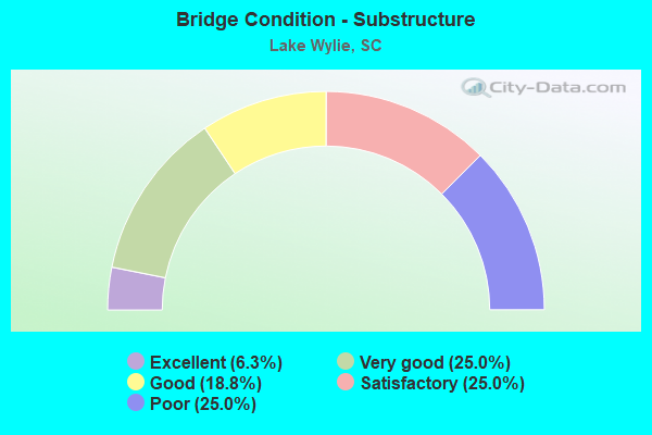
- Bridge Condition - Substructure
- 6.3%Excellent
- 25.0%Very good
- 18.8%Good
- 25.0%Satisfactory
- 25.0%Poor
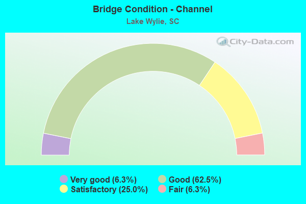
- Bridge Condition - Channel
- 6.3%Very good
- 62.5%Good
- 25.0%Satisfactory
- 6.3%Fair
Find on map >> Show street view
Structure Number: 912, Location: 9.4MI N OF NEWPORT (Lat: 35.125325, Lng: -81.081378), Route carried "on" structure: State highway 274, Year Built: 1938, Year Reconstructed: 1973, Status: Open, Structure Length: 3.84m (12.60ft), Average Daily Traffic: 19,100 (year 2020), Truck Traffic: 6%, Average Future Daily Traffic: 25,403 (year 2040), Design Load: H 15, Features Intersected: MILL CREEK
Minimum Vertical Clearance: 30+ m (98+ ft), Kilometerpoint: 24.790, Lanes on structure: 2, Owner: State Highway Agency, Approaching Roadway Width: 11.0m (36.1ft), Material/Design: Steel, Design/Construction: Stringer/Multi-beam, Number Of Spans In Main Unit: 5, Length of Maximum Span: 7.6m (24.9ft), Curb-To-Curb Width: 13.5m (44.3ft), Out-to-Out Width: 14.6m (47.9ft)
Condition: Deck: Fair, Superstructure: Fair, Substructure: Poor, Channel: Good, Operating Rating: 39.0 metric tons, Method Used To Determine Operating Rating: Allowable Stress (AS), Inventory Rating: 22.7 metric tons, Method Used To Determine Inventory Rating: Allowable Stress (AS), Structural Evaluation: Meets minimum limits, Deck Geometry: Superior to present desirable criteria, Waterway Adequacy: Better than present minimum criteria, Approach Roadway Alignment: Equal to present desirable criteria, Length Of Structure Improvement: 4.73m (15.52ft), Designated Inspection Frequency: Every 12 months, Inspection Date: May 2021, Bridge Improvement Cost: $230,000, Roadway Improvement Cost: $12,000, Total Project Cost: $253,000 ( Estimate for 2021), Deck Structure Type: Concrete Cast-file-Place, Wearing Surface/Protective System: Wearing Surface: Bituminous
Find on map >> Show street view
Structure Number: 2635, Location: 6.9 MI E OF CLOVER (Lat: 35.120897, Lng: -81.113047), Route carried "on" structure: State highway 557, Year Built: 1957, Status: Open, Structure Length: 5.85m (19.19ft), Average Daily Traffic: 9,400 (year 2021), Truck Traffic: 4%, Average Future Daily Traffic: 14,570 (year 2041), Design Load: HS 15, Features Intersected: CROWDERS CREEK
Minimum Vertical Clearance: 30+ m (98+ ft), Kilometerpoint: 7.941, Lanes on structure: 2, Base Highway Network: Yes, Owner: State Highway Agency, Approaching Roadway Width: 10.1m (33.1ft), Material/Design: Concrete, Design/Construction: Tee Beam, Number Of Spans In Main Unit: 6, Length of Maximum Span: 9.8m (32.2ft), Curb-To-Curb Width: 8.0m (26.2ft), Out-to-Out Width: 9.0m (29.5ft)
Condition: Deck: Satisfactory, Superstructure: Satisfactory, Substructure: Satisfactory, Channel: Fair, Operating Rating: 36.3 metric tons, Method Used To Determine Operating Rating: Load and Resistance Factor Rating (LRFR) rating reported by rating factor(RF) method using HL-93 loadings, Inventory Rating: 25.6 metric tons, Method Used To Determine Inventory Rating: Load and Resistance Factor Rating (LRFR) rating reported by rating factor(RF) method using HL-93 loadings, Structural Evaluation: Equal to present minimum criteria, Deck Geometry: High priority of replacement, Waterway Adequacy: Better than present minimum criteria, Approach Roadway Alignment: Equal to present desirable criteria, Length Of Structure Improvement: 6.82m (22.38ft), Designated Inspection Frequency: Every 24 months, Underwater Inspection Frequency: Every 60 months, Inspection Date: June 2020, Underwater Inspection Date: December 2021, Bridge Improvement Cost: $482,000, Roadway Improvement Cost: $121,000, Total Project Cost: $723,000 ( Estimate for 2022), Deck Structure Type: Concrete Cast-file-Place, Wearing Surface/Protective System: Wearing Surface: Monolithic Concrete
Find on map >> Show street view
Structure Number: 3137, Location: 8.3 MI N E YORK (Lat: 35.060200, Lng: -81.122878), Route carried "on" structure: State highway 49, Year Built: 1959, Status: Posted for load, Structure Length: 7.32m (24.02ft), Average Daily Traffic: 7,200 (year 2021), Truck Traffic: 6%, Average Future Daily Traffic: 9,576 (year 2041), Design Load: HS 15, Features Intersected: ALLISON CREEK
Minimum Vertical Clearance: 30+ m (98+ ft), Kilometerpoint: 42.313, Lanes on structure: 2, Owner: State Highway Agency, Approaching Roadway Width: 10.1m (33.1ft), Skew: 2 degrees, Material/Design: Concrete, Design/Construction: Tee Beam, Number Of Spans In Main Unit: 8, Length of Maximum Span: 9.1m (29.9ft), Curb-To-Curb Width: 8.6m (28.2ft), Out-to-Out Width: 9.5m (31.2ft)
Condition: Deck: Fair, Superstructure: Fair, Substructure: Poor, Channel: Good, Operating Rating: 36.9 metric tons, Method Used To Determine Operating Rating: Load and Resistance Factor Rating (LRFR) rating reported by rating factor(RF) method using HL-93 loadings, Inventory Rating: 26.9 metric tons, Method Used To Determine Inventory Rating: Load and Resistance Factor Rating (LRFR) rating reported by rating factor(RF) method using HL-93 loadings, Structural Evaluation: Meets minimum limits, Deck Geometry: Meets minimum limits, Waterway Adequacy: Equal to present desirable criteria, Approach Roadway Alignment: Equal to present desirable criteria, Length Of Structure Improvement: 8.34m (27.36ft), Designated Inspection Frequency: Every 12 months, Other Special Inspection Frequency: Every 12 months, Inspection Date: May 2021, Other Special Inspection Date: October 2021, Bridge Improvement Cost: $1,055,000, Roadway Improvement Cost: $264,000, Total Project Cost: $1,583,000 ( Estimate for 2022), Deck Structure Type: Concrete Cast-file-Place, Wearing Surface/Protective System: Wearing Surface: Monolithic Concrete
Find on map >> Show street view
Structure Number: 4239, Location: 6.1 MI E CLOVER (Lat: 35.124414, Lng: -81.120431), Route carried "on" structure: State highway 152, Year Built: 2011, Status: Open, Structure Length: 6.10m (20.01ft), Average Daily Traffic: 1,150 (year 2020), Truck Traffic: 4%, Average Future Daily Traffic: 1,254 (year 2040), Design Load: HL 93, Features Intersected: CROWDERS CREEK
Minimum Vertical Clearance: 30+ m (98+ ft), Kilometerpoint: 6.671, Lanes on structure: 2, Owner: State Highway Agency, Approaching Roadway Width: 11.0m (36.1ft), Material/Design: Prestressed concrete continuous, Design/Construction: Stringer/Multi-beam, Number Of Spans In Main Unit: 1, Number Of Approach Spans: 2, Length of Maximum Span: 24.4m (80.1ft), Curb-To-Curb Width: 10.4m (34.1ft), Out-to-Out Width: 11.3m (37.1ft)
Condition: Deck: Very good, Superstructure: Very good, Substructure: Very good, Channel: Good, Operating Rating: 51.8 metric tons, Method Used To Determine Operating Rating: Load and Resistance Factor Rating (LRFR) rating reported by rating factor(RF) method using HL-93 loadings, Inventory Rating: 31.1 metric tons, Method Used To Determine Inventory Rating: Load and Resistance Factor Rating (LRFR) rating reported by rating factor(RF) method using HL-93 loadings, Structural Evaluation: Better than present minimum criteria, Deck Geometry: Equal to present minimum criteria, Waterway Adequacy: Equal to present desirable criteria, Approach Roadway Alignment: Better than present minimum criteria, Length Of Structure Improvement: 6.10m (20.01ft), Designated Inspection Frequency: Every 24 months, Inspection Date: March 2021, Deck Structure Type: Concrete Cast-file-Place, Wearing Surface/Protective System: Wearing Surface: Monolithic Concrete
Find on map >> Show street view
Structure Number: 6021, Location: 13.3 MI N E YORK (Lat: 35.110997, Lng: -81.088261), Route carried "on" structure: State highway 49, Year Built: 1971, Year Reconstructed: 2005, Status: Open, Structure Length: 22.40m (73.49ft), Average Daily Traffic: 27,600 (year 2020), Truck Traffic: 7%, Average Future Daily Traffic: 42,780 (year 2040), Design Load: H 20, Features Intersected: CROWDERS CREEK
Minimum Vertical Clearance: 30+ m (98+ ft), Kilometerpoint: 49.027, Lanes on structure: 4, Base Highway Network: Yes, Owner: State Highway Agency, Approaching Roadway Width: 19.5m (64.0ft), Material/Design: Steel, Design/Construction: Stringer/Multi-beam, Number Of Spans In Main Unit: 7, Number Of Approach Spans: 7, Length of Maximum Span: 25.6m (84.0ft), Curb or Sidewalk Widths: Left: 1.5m (4.9ft), Right: 0.0m, Curb-To-Curb Width: 21.2m (69.6ft), Out-to-Out Width: 23.7m (77.8ft)
Condition: Deck: Fair, Superstructure: Satisfactory, Substructure: Poor, Channel: Good, Operating Rating: 21.7 metric tons, Method Used To Determine Operating Rating: Load and Resistance Factor Rating (LRFR) rating reported by rating factor(RF) method using HL-93 loadings, Inventory Rating: 16.8 metric tons, Method Used To Determine Inventory Rating: Load and Resistance Factor Rating (LRFR) rating reported by rating factor(RF) method using HL-93 loadings, Structural Evaluation: Meets minimum limits, Deck Geometry: Superior to present desirable criteria, Waterway Adequacy: Better than present minimum criteria, Approach Roadway Alignment: Equal to present desirable criteria, Bridge Posting: Required (Relationship of Operating Rating to Maximum Legal Load: 30.0 - 39.9% below), Length Of Structure Improvement: 22.56m (74.02ft), Designated Inspection Frequency: Every 12 months, Inspection Date: May 2021, Bridge Improvement Cost: $3,239,000, Roadway Improvement Cost: $810,000, Total Project Cost: $4,859,000 ( Estimate for 2021), Deck Structure Type: Concrete Cast-file-Place, Wearing Surface/Protective System: Wearing Surface: Monolithic Concrete
Find on map >> Show street view
Structure Number: 6818, Location: 4.1 MI N OF NEWPORT (Lat: 35.049722, Lng: -81.098056), Route carried "on" structure: State highway 274, Year Built: 1975, Status: Open, Structure Length: 9.75m (31.99ft), Average Daily Traffic: 6,550 (year 2020), Truck Traffic: 6%, Average Future Daily Traffic: 8,712 (year 2040), Design Load: HS 20, Features Intersected: BIG ALLISON CREEK
Minimum Vertical Clearance: 30+ m (98+ ft), Kilometerpoint: 15.900, Lanes on structure: 2, Owner: State Highway Agency, Approaching Roadway Width: 13.4m (44.0ft), Material/Design: Steel, Design/Construction: Stringer/Multi-beam, Number Of Spans In Main Unit: 4, Length of Maximum Span: 24.4m (80.1ft), Curb-To-Curb Width: 13.4m (44.0ft), Out-to-Out Width: 14.4m (47.2ft)
Condition: Deck: Satisfactory, Superstructure: Satisfactory, Substructure: Poor, Channel: Satisfactory, Operating Rating: 64.2 metric tons, Method Used To Determine Operating Rating: Load and Resistance Factor Rating (LRFR) rating reported by rating factor(RF) method using HL-93 loadings, Inventory Rating: 49.6 metric tons, Method Used To Determine Inventory Rating: Load and Resistance Factor Rating (LRFR) rating reported by rating factor(RF) method using HL-93 loadings, Structural Evaluation: Meets minimum limits, Deck Geometry: Equal to present minimum criteria, Waterway Adequacy: Equal to present desirable criteria, Approach Roadway Alignment: Equal to present desirable criteria, Length Of Structure Improvement: 10.82m (35.50ft), Designated Inspection Frequency: Every 12 months, Underwater Inspection Frequency: Every 60 months, Inspection Date: May 2021, Underwater Inspection Date: September 2021, Bridge Improvement Cost: $456,000, Roadway Improvement Cost: $23,000, Total Project Cost: $502,000 ( Estimate for 2021), Deck Structure Type: Concrete Cast-file-Place, Wearing Surface/Protective System: Wearing Surface: Monolithic Concrete
Find on map >> Show street view
Structure Number: 7863, Location: 6.2 MI E CLOVER (Lat: 35.117375, Lng: -81.117347), Route carried "on" structure: State highway 152, Year Built: 1984, Status: Open, Structure Length: 3.66m (12.01ft), Average Daily Traffic: 2,400 (year 2020), Truck Traffic: 5%, Average Future Daily Traffic: 3,072 (year 2040), Design Load: HS 20, Features Intersected: BEAVERDAM CREEK
Minimum Vertical Clearance: 30+ m (98+ ft), Kilometerpoint: 5.813, Lanes on structure: 2, Owner: State Highway Agency, Approaching Roadway Width: 11.0m (36.1ft), Material/Design: Steel, Design/Construction: Stringer/Multi-beam, Number Of Spans In Main Unit: 1, Number Of Approach Spans: 2, Length of Maximum Span: 18.3m (60.0ft), Curb-To-Curb Width: 9.8m (32.2ft), Out-to-Out Width: 10.9m (35.8ft)
Condition: Deck: Good, Superstructure: Good, Substructure: Good, Channel: Good, Operating Rating: 41.8 metric tons, Method Used To Determine Operating Rating: Load and Resistance Factor Rating (LRFR) rating reported by rating factor(RF) method using HL-93 loadings, Inventory Rating: 32.4 metric tons, Method Used To Determine Inventory Rating: Load and Resistance Factor Rating (LRFR) rating reported by rating factor(RF) method using HL-93 loadings, Structural Evaluation: Better than present minimum criteria, Deck Geometry: Meets minimum limits, Waterway Adequacy: Equal to present desirable criteria, Approach Roadway Alignment: Equal to present minimum criteria, Length Of Structure Improvement: 3.66m (12.01ft), Designated Inspection Frequency: Every 24 months, Inspection Date: March 2021, Deck Structure Type: Concrete Cast-file-Place, Wearing Surface/Protective System: Wearing Surface: Monolithic Concrete
Find on map >> Show street view
Structure Number: 7957, Location: 10.5 MI NE YORK (Lat: 35.114003, Lng: -81.128522), Route carried "on" structure: State highway 114, Year Built: 1985, Status: Open, Structure Length: 5.49m (18.01ft), Average Daily Traffic: 850 (year 2020), Truck Traffic: 6%, Average Future Daily Traffic: 1,794 (year 2040), Design Load: HS 20, Features Intersected: BEAVERDAM CREEK
Minimum Vertical Clearance: 30+ m (98+ ft), Kilometerpoint: 7.957, Lanes on structure: 2, Owner: State Highway Agency, Approaching Roadway Width: 12.2m (40.0ft), Material/Design: Concrete, Design/Construction: Slab, Number Of Spans In Main Unit: 6, Length of Maximum Span: 9.1m (29.9ft), Curb-To-Curb Width: 9.8m (32.2ft), Out-to-Out Width: 10.8m (35.4ft)
Condition: Deck: Good, Superstructure: Good, Substructure: Satisfactory, Channel: Good, Operating Rating: 49.6 metric tons, Method Used To Determine Operating Rating: Load and Resistance Factor Rating (LRFR) rating reported by rating factor(RF) method using HL-93 loadings, Inventory Rating: 38.2 metric tons, Method Used To Determine Inventory Rating: Load and Resistance Factor Rating (LRFR) rating reported by rating factor(RF) method using HL-93 loadings, Structural Evaluation: Equal to present minimum criteria, Deck Geometry: Equal to present minimum criteria, Waterway Adequacy: Equal to present desirable criteria, Approach Roadway Alignment: Equal to present desirable criteria, Length Of Structure Improvement: 5.49m (18.01ft), Designated Inspection Frequency: Every 24 months, Inspection Date: March 2021, Deck Structure Type: Concrete Cast-file-Place, Wearing Surface/Protective System: Wearing Surface: Monolithic Concrete
Find on map >> Show street view
Structure Number: 8701, Location: 9.3 MI NE CLOVER (Lat: 35.140542, Lng: -81.067347), Route carried "on" structure: State highway 177, Year Built: 1993, Status: Open, Structure Length: 1.22m (4.00ft), Average Daily Traffic: 9,800 (year 2020), Truck Traffic: 9%, Average Future Daily Traffic: 20,678 (year 2040), Design Load: HS 20, Features Intersected: BR CATAWBA RIVER
Minimum Vertical Clearance: 30+ m (98+ ft), Kilometerpoint: 1.555, Lanes on structure: 2, Owner: State Highway Agency, Approaching Roadway Width: 9.4m (30.8ft), Material/Design: Prestressed concrete, Design/Construction: Slab, Number Of Spans In Main Unit: 1, Length of Maximum Span: 12.2m (40.0ft), Curb-To-Curb Width: 10.5m (34.4ft), Out-to-Out Width: 11.9m (39.0ft)
Condition: Deck: Very good, Superstructure: Very good, Substructure: Satisfactory, Channel: Satisfactory, Operating Rating: 64.4 metric tons, Method Used To Determine Operating Rating: Load Factor (LF), Inventory Rating: 39.0 metric tons, Method Used To Determine Inventory Rating: Load Factor (LF), Structural Evaluation: Equal to present minimum criteria, Deck Geometry: Meets minimum limits, Waterway Adequacy: Better than present minimum criteria, Approach Roadway Alignment: Better than present minimum criteria, Length Of Structure Improvement: 1.22m (4.00ft), Designated Inspection Frequency: Every 24 months, Inspection Date: March 2021, Deck Structure Type: Concrete Precast Panels, Wearing Surface/Protective System: Wearing Surface: Bituminous
Find on map >> Show street view
Structure Number: 8803, Location: 7.7 MI NE YORK (Lat: 35.064872, Lng: -81.138136), Route carried "on" structure: State highway 114, Year Built: 1994, Status: Open, Structure Length: 4.11m (13.48ft), Average Daily Traffic: 850 (year 2020), Truck Traffic: 6%, Average Future Daily Traffic: 1,131 (year 2040), Design Load: HS 20, Features Intersected: ALLISON CREEK
Minimum Vertical Clearance: 30+ m (98+ ft), Kilometerpoint: 1.936, Lanes on structure: 2, Owner: State Highway Agency, Approaching Roadway Width: 9.1m (29.9ft), Material/Design: Prestressed concrete, Design/Construction: Slab, Number Of Spans In Main Unit: 3, Number Of Approach Spans: 1, Length of Maximum Span: 12.2m (40.0ft), Curb-To-Curb Width: 10.5m (34.4ft), Out-to-Out Width: 11.9m (39.0ft)
Condition: Deck: Good, Superstructure: Good, Substructure: Satisfactory, Channel: Good, Operating Rating: 21.4 metric tons, Method Used To Determine Operating Rating: Load and Resistance Factor Rating (LRFR) rating reported by rating factor(RF) method using HL-93 loadings, Inventory Rating: 16.2 metric tons, Method Used To Determine Inventory Rating: Load and Resistance Factor Rating (LRFR) rating reported by rating factor(RF) method using HL-93 loadings, Structural Evaluation: Meets minimum limits, Deck Geometry: Equal to present minimum criteria, Waterway Adequacy: Equal to present desirable criteria, Approach Roadway Alignment: Equal to present desirable criteria, Length Of Structure Improvement: 4.11m (13.48ft), Designated Inspection Frequency: Every 24 months, Inspection Date: March 2021, Deck Structure Type: Concrete Precast Panels, Wearing Surface/Protective System: Wearing Surface: Bituminous
Find on map >> Show street view
Structure Number: 939, Location: 7.1 MI NE CLOVER (Lat: 35.133636, Lng: -81.102022), Route carried "on" structure: State highway 918, Year Built: 1998, Status: Open, Structure Length: 2.74m (8.99ft), Average Daily Traffic: 1,550 (year 2020), Truck Traffic: 5%, Average Future Daily Traffic: 1,984 (year 2040), Design Load: HS 20, Features Intersected: MILL CREEK
Minimum Vertical Clearance: 30+ m (98+ ft), Kilometerpoint: 0.552, Lanes on structure: 2, Owner: State Highway Agency, Approaching Roadway Width: 8.5m (27.9ft), Material/Design: Prestressed concrete, Design/Construction: Slab, Number Of Spans In Main Unit: 3, Length of Maximum Span: 9.1m (29.9ft), Curb-To-Curb Width: 10.4m (34.1ft), Out-to-Out Width: 11.9m (39.0ft)
Condition: Deck: Very good, Superstructure: Very good, Substructure: Very good, Channel: Satisfactory, Operating Rating: 28.5 metric tons, Method Used To Determine Operating Rating: Load and Resistance Factor Rating (LRFR) rating reported by rating factor(RF) method using HL-93 loadings, Inventory Rating: 20.1 metric tons, Method Used To Determine Inventory Rating: Load and Resistance Factor Rating (LRFR) rating reported by rating factor(RF) method using HL-93 loadings, Structural Evaluation: Somewhat better than minimum adequacy, Deck Geometry: Equal to present minimum criteria, Waterway Adequacy: Better than present minimum criteria, Approach Roadway Alignment: Equal to present desirable criteria, Length Of Structure Improvement: 2.74m (8.99ft), Designated Inspection Frequency: Every 24 months, Inspection Date: March 2021, Deck Structure Type: Concrete Precast Panels, Wearing Surface/Protective System: Wearing Surface: Bituminous
Find on map >> Show street view
Structure Number: 9477, Location: 7.0 MI E. OF CLOVER (Lat: 35.090967, Lng: -81.106144), Route carried "on" structure: State highway 55, Year Built: 1999, Status: Open, Structure Length: 1.92m (6.30ft), Average Daily Traffic: 7,500 (year 2020), Truck Traffic: 5%, Average Future Daily Traffic: 9,975 (year 2040), Design Load: HS 20, Features Intersected: BRANCH OF CROWDERS CREEK
Minimum Vertical Clearance: 30+ m (98+ ft), Kilometerpoint: 32.353, Lanes on structure: 2, Owner: State Highway Agency, Approaching Roadway Width: 10.4m (34.1ft), Material/Design: Prestressed concrete, Design/Construction: Stringer/Multi-beam, Number Of Spans In Main Unit: 1, Length of Maximum Span: 19.2m (63.0ft), Curb-To-Curb Width: 13.4m (44.0ft), Out-to-Out Width: 14.3m (46.9ft)
Condition: Deck: Very good, Superstructure: Very good, Substructure: Very good, Channel: Good, Operating Rating: 68.0 metric tons, Method Used To Determine Operating Rating: Load and Resistance Factor Rating (LRFR) rating reported by rating factor(RF) method using HL-93 loadings, Inventory Rating: 52.5 metric tons, Method Used To Determine Inventory Rating: Load and Resistance Factor Rating (LRFR) rating reported by rating factor(RF) method using HL-93 loadings, Structural Evaluation: Equal to present desirable criteria, Deck Geometry: Equal to present minimum criteria, Waterway Adequacy: Better than present minimum criteria, Approach Roadway Alignment: Equal to present desirable criteria, Length Of Structure Improvement: 1.92m (6.30ft), Designated Inspection Frequency: Every 24 months, Inspection Date: May 2020, Deck Structure Type: Concrete Cast-file-Place, Wearing Surface/Protective System: Wearing Surface: Monolithic Concrete
Find on map >> Show street view
Structure Number: 9755, Location: 4.5 MILES N OF ROCK HILL (Lat: 35.044617, Lng: -81.070436), Route carried "on" structure: State highway 1132, Year Built: 1972, Status: Open, Structure Length: 14.63m (48.00ft), Average Daily Traffic: 2,500 (year 2020), Truck Traffic: 5%, Average Future Daily Traffic: 3,200 (year 2040), Design Load: HS 15, Features Intersected: LAKE WYLIE
Minimum Vertical Clearance: 30+ m (98+ ft), Kilometerpoint: 3.108, Lanes on structure: 2, Owner: State Highway Agency, Approaching Roadway Width: 10.7m (35.1ft), Material/Design: Steel continuous, Design/Construction: Stringer/Multi-beam, Number Of Spans In Main Unit: 5, Length of Maximum Span: 45.7m (149.9ft), Curb-To-Curb Width: 11.3m (37.1ft), Out-to-Out Width: 11.9m (39.0ft)
Condition: Deck: Satisfactory, Superstructure: Good, Substructure: Good, Channel: Very good, Operating Rating: 28.5 metric tons, Method Used To Determine Operating Rating: Load and Resistance Factor Rating (LRFR) rating reported by rating factor(RF) method using HL-93 loadings, Inventory Rating: 22.0 metric tons, Method Used To Determine Inventory Rating: Load and Resistance Factor Rating (LRFR) rating reported by rating factor(RF) method using HL-93 loadings, Structural Evaluation: Somewhat better than minimum adequacy, Deck Geometry: Somewhat better than minimum adequacy, Waterway Adequacy: Superior to present desirable criteria, Approach Roadway Alignment: Equal to present desirable criteria, Bridge Posting: Required (Relationship of Operating Rating to Maximum Legal Load: 0.1 - 9.9% below), Length Of Structure Improvement: 14.63m (48.00ft), Designated Inspection Frequency: Every 24 months, Underwater Inspection Frequency: Every 60 months, Inspection Date: April 2021, Underwater Inspection Date: July 2019, Deck Structure Type: Concrete Cast-file-Place, Wearing Surface/Protective System: Wearing Surface: Monolithic Concrete
Find on map >> Show street view
Structure Number: 9946, Location: 4.1 MI N OF NEWPORT (Lat: 35.049722, Lng: -81.098056), Route carried "on" structure: State highway 274, Year Built: 2011, Status: Open, Structure Length: 9.51m (31.20ft), Average Daily Traffic: 6,550 (year 2020), Truck Traffic: 6%, Average Future Daily Traffic: 8,712 (year 2040), Design Load: HS 25 or greater, Features Intersected: BIG ALLISON CREEK
Minimum Vertical Clearance: 30+ m (98+ ft), Kilometerpoint: 15.820, Lanes on structure: 2, Owner: State Highway Agency, Approaching Roadway Width: 13.1m (43.0ft), Material/Design: Concrete continuous, Design/Construction: Stringer/Multi-beam, Number Of Spans In Main Unit: 4, Length of Maximum Span: 23.8m (78.1ft), Curb-To-Curb Width: 13.0m (42.7ft), Out-to-Out Width: 13.9m (45.6ft)
Condition: Deck: Very good, Superstructure: Very good, Substructure: Very good, Channel: Good, Operating Rating: 48.6 metric tons, Method Used To Determine Operating Rating: Load and Resistance Factor Rating (LRFR) rating reported by rating factor(RF) method using HL-93 loadings, Inventory Rating: 37.6 metric tons, Method Used To Determine Inventory Rating: Load and Resistance Factor Rating (LRFR) rating reported by rating factor(RF) method using HL-93 loadings, Structural Evaluation: Equal to present desirable criteria, Deck Geometry: Somewhat better than minimum adequacy, Waterway Adequacy: Equal to present desirable criteria, Approach Roadway Alignment: Equal to present desirable criteria, Length Of Structure Improvement: 9.51m (31.20ft), Designated Inspection Frequency: Every 24 months, Underwater Inspection Frequency: Every 60 months, Inspection Date: May 2020, Underwater Inspection Date: September 2021, Deck Structure Type: Concrete Precast Panels, Wearing Surface/Protective System: Wearing Surface: Monolithic Concrete
Find on map >> Show street view
Structure Number: 10099, Location: NC/SC STATE LINE (Lat: 35.101772, Lng: -81.040136), Route carried "on" structure: State highway 49, Year Built: 2003, Status: Open, Structure Length: 43.19m (141.70ft), Average Daily Traffic: 32,900 (year 2020), Truck Traffic: 11%, Average Future Daily Traffic: 43,757 (year 2040), Design Load: HS 25 or greater, Features Intersected: CATAWBA RIVER
Minimum Vertical Clearance: 0.00m, Kilometerpoint: 54.914, Lanes on structure: 4, Owner: State Agenciy, Approaching Roadway Width: 15.8m (51.8ft), Material/Design: Prestressed concrete continuous, Design/Construction: Stringer/Multi-beam, Number Of Spans In Main Unit: 17, Length of Maximum Span: 26.2m (86.0ft), Curb or Sidewalk Widths: Left: 1.5m (4.9ft), Right: 1.5m (4.9ft), Curb-To-Curb Width: 15.5m (50.9ft), Out-to-Out Width: 20.7m (67.9ft)
Condition: Deck: Good, Superstructure: Good, Substructure: Good, Channel: Good, Operating Rating: 89.8 metric tons, Method Used To Determine Operating Rating: Load Factor (LF), Inventory Rating: 44.5 metric tons, Method Used To Determine Inventory Rating: Load Factor (LF), Structural Evaluation: Better than present minimum criteria, Deck Geometry: Meets minimum limits, Waterway Adequacy: Better than present minimum criteria, Approach Roadway Alignment: Equal to present desirable criteria, Length Of Structure Improvement: 43.19m (141.70ft), Designated Inspection Frequency: Every 24 months, Inspection Date: September 2020, Deck Structure Type: Concrete Cast-file-Place, Wearing Surface/Protective System: Wearing Surface: Monolithic Concrete
Find on map >> Show street view
Structure Number: 10488, Location: 9 MI NE OF CLOVER (Lat: 35.135556, Lng: -81.075833), Route carried "on" structure: State highway 177, Year Built: 2021, Status: Open, Structure Length: 2.44m (8.01ft), Average Daily Traffic: 9,800 (year 2020), Truck Traffic: 9%, Average Future Daily Traffic: 20,678 (year 2040), Design Load: HS 20, Features Intersected: BR CATAWBA RIVER
Minimum Vertical Clearance: 30+ m (98+ ft), Kilometerpoint: 0.600, Lanes on structure: 2, Owner: State Highway Agency, Approaching Roadway Width: 16.8m (55.1ft), Material/Design: Prestressed concrete, Design/Construction: Slab, Number Of Spans In Main Unit: 1, Length of Maximum Span: 24.4m (80.1ft), Curb or Sidewalk Widths: Left: 2.4m (7.9ft), Right: 2.4m (7.9ft), Curb-To-Curb Width: 13.8m (45.3ft), Out-to-Out Width: 16.2m (53.1ft)
Condition: Deck: Excellent, Superstructure: Excellent, Substructure: Excellent, Channel: Satisfactory, Operating Rating: 61.9 metric tons, Method Used To Determine Operating Rating: Load and Resistance Factor Rating (LRFR) rating reported by rating factor(RF) method using HL-93 loadings, Inventory Rating: 42.8 metric tons, Method Used To Determine Inventory Rating: Load and Resistance Factor Rating (LRFR) rating reported by rating factor(RF) method using HL-93 loadings, Structural Evaluation: Superior to present desirable criteria, Deck Geometry: Superior to present desirable criteria, Waterway Adequacy: Equal to present desirable criteria, Approach Roadway Alignment: Equal to present desirable criteria, Bridge Posting: Required (Relationship of Operating Rating to Maximum Legal Load: > 39.9% below), Length Of Structure Improvement: 3.23m (10.60ft), Designated Inspection Frequency: Every 24 months, Inspection Date: March 2021, Bridge Improvement Cost: $409,000, Roadway Improvement Cost: $102,000, Total Project Cost: $614,000 ( Estimate for 2021), Deck Structure Type: Concrete Cast-file-Place, Wearing Surface/Protective System: Wearing Surface: Bituminous