Bridge Statistics for Lake Worth, Florida (FL)
Condition, Traffic, Stress, Structural Evaluation, Project Costs
- National Bridge Inventory (NBI) Statistics
- 35Number of bridges
- 1,155ft / 352mTotal length
- 1,736,856Total average daily traffic
- 107,512Total average daily truck traffic
- National Bridge Inventory (NBI) Registered Bridges for Lake Worth
- No street view available for this location
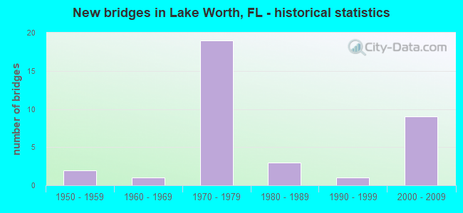
- New bridges - historical statistics
- 21950-1959
- 11960-1969
- 191970-1979
- 31980-1989
- 11990-1999
- 92000-2009

- Reconstructed bridges - Historical Statistics
- 11990-1999
- 42000-2009
- 22010-2019


- Bridge Condition - Deck
- 25.0%Very good
- 58.3%Good
- 8.3%Satisfactory
- 8.3%Fair

- Bridge Condition - Superstructure
- 25.0%Very good
- 54.2%Good
- 4.2%Satisfactory
- 16.7%Fair

- Bridge Condition - Substructure
- 8.3%Very good
- 87.5%Good
- 4.2%Satisfactory

- Bridge Condition - Channel
- 6.7%Very good
- 80.0%Good
- 13.3%Fair
Find on map >> Show street view
Structure Number: 930073, Location: .4mi. East of Congress (Lat: 26.617236, Lng: -80.083569), Route carried "on" structure: State highway 802, Year Built: 1959, Year Reconstructed: 2012, Status: Open, Structure Length: 3.20m (10.50ft), Average Daily Traffic: 26,000 (year 2018), Truck Traffic: 4%, Average Future Daily Traffic: 45,110 (year 2040), Design Load: HS 20, Features Intersected: Kellers Canal
Minimum Vertical Clearance: 30+ m (98+ ft), Kilometerpoint: 12.123, Lanes on structure: 4, Owner: State Highway Agency, Approaching Roadway Width: 21.2m (69.6ft), Skew: 20 degrees, Material/Design: Prestressed concrete, Design/Construction: Slab, Number Of Spans In Main Unit: 3, Length of Maximum Span: 10.7m (35.1ft), Curb or Sidewalk Widths: Left: 1.5m (4.9ft), Right: 1.5m (4.9ft), Curb-To-Curb Width: 25.0m (82.0ft), Out-to-Out Width: 29.8m (97.8ft)
Condition: Deck: Satisfactory, Superstructure: Satisfactory, Substructure: Good, Channel: Good, Operating Rating: 47.7 metric tons, Method Used To Determine Operating Rating: Load Factor (LF), Inventory Rating: 41.4 metric tons, Method Used To Determine Inventory Rating: Load Factor (LF), Structural Evaluation: Equal to present minimum criteria, Deck Geometry: Superior to present desirable criteria, Waterway Adequacy: Better than present minimum criteria, Approach Roadway Alignment: Equal to present desirable criteria, Designated Inspection Frequency: Every 24 months, Underwater Inspection Frequency: Every 24 months, Inspection Date: Febuary 2021, Underwater Inspection Date: Febuary 2021, Deck Structure Type: Concrete Precast Panels
Find on map >> Show street view
Structure Number: 930104, Location: Lake Ave / ICWW (Lat: 26.615400, Lng: -80.041339), Route carried "on" structure: State highway 802, Year Built: 1973, Status: Open, Structure Length: 47.73m (156.59ft), Average Daily Traffic: 5,950 (year 2021), Truck Traffic: 10%, Average Future Daily Traffic: 10,323 (year 2042), Design Load: H 20, Features Intersected: Intracoastal Waterway
Minimum Vertical Clearance: 5.46m (17.91ft), Kilometerpoint: 15.895, Lanes on structure: 2, Owner: State Highway Agency, Approaching Roadway Width: 8.0m (26.2ft), Navigation Control: Yes ( Vertical Clearance: 10.7m (35.1ft), Horizontal Clearance: 27.4m (89.9ft)), Material/Design: Steel, Design/Construction: Movable - Bascule, Number Of Spans In Main Unit: 1, Number Of Approach Spans: 20, Length of Maximum Span: 37.0m (121.4ft), Curb or Sidewalk Widths: Left: 1.5m (4.9ft), Right: 0.0m, Curb-To-Curb Width: 9.1m (29.9ft), Out-to-Out Width: 11.5m (37.7ft)
Condition: Deck: Satisfactory, Superstructure: Fair, Substructure: Good, Channel: Good, Operating Rating: 46.3 metric tons, Method Used To Determine Operating Rating: Load Factor (LF), Inventory Rating: 28.1 metric tons, Method Used To Determine Inventory Rating: Load Factor (LF), Structural Evaluation: Somewhat better than minimum adequacy, Deck Geometry: Meets minimum limits, Waterway Adequacy: Superior to present desirable criteria, Approach Roadway Alignment: Equal to present desirable criteria, Designated Inspection Frequency: Every 24 months, Critical Feature Inspection Frequency: Every 24 months, Underwater Inspection Frequency: Every 24 months, Other Special Inspection Frequency: Every 12 months, Inspection Date: June 2021, Critical Feature Inspection Date: June 2021, Underwater Inspection Date: June 2021, Other Special Inspection Date: June 2021, Deck Structure Type: Concrete Cast-file-Place
Find on map >> Show street view
Structure Number: 930107, Location: 0.5MI. W OF I-95 (Lat: 26.628178, Lng: -80.078414), Route carried "on" structure: County highway , Year Built: 1966, Status: Open, Structure Length: 2.83m (9.28ft), Average Daily Traffic: 44,000 (year 2020), Truck Traffic: 4%, Average Future Daily Traffic: 76,340 (year 2042), Design Load: HS 20, Features Intersected: KELLER CANAL E-4, Facility Carried by Structure: 10TH AVE. NORTH
Minimum Vertical Clearance: 30+ m (98+ ft), Kilometerpoint: 3.441, Lanes on structure: 4, Owner: County Highway Agency, Approaching Roadway Width: 17.4m (57.1ft), Skew: 2 degrees, Material/Design: Prestressed concrete, Design/Construction: Slab, Number Of Spans In Main Unit: 3, Length of Maximum Span: 9.4m (30.8ft), Curb-To-Curb Width: 19.3m (63.3ft), Out-to-Out Width: 20.2m (66.3ft)
Condition: Deck: Good, Superstructure: Good, Substructure: Good, Channel: Good, Operating Rating: 71.3 metric tons, Method Used To Determine Operating Rating: Allowable Stress (AS), Inventory Rating: 45.1 metric tons, Method Used To Determine Inventory Rating: Allowable Stress (AS), Structural Evaluation: Better than present minimum criteria, Deck Geometry: Equal to present minimum criteria, Waterway Adequacy: Equal to present desirable criteria, Approach Roadway Alignment: Equal to present desirable criteria, Designated Inspection Frequency: Every 24 months, Underwater Inspection Frequency: Every 24 months, Inspection Date: April 2020, Underwater Inspection Date: April 2020, Deck Structure Type: Concrete Precast Panels, Wearing Surface/Protective System: Wearing Surface: Bituminous
Find on map >> Show street view
Structure Number: 930259, Location: Lake Worth (Lat: 26.636292, Lng: -80.068389), Route carried "on" structure: Interstate 95, Year Built: 1975, Year Reconstructed: 2008, Status: Open, Structure Length: 3.71m (12.17ft), Average Daily Traffic: 181,000 (year 2020), Truck Traffic: 5%, Average Future Daily Traffic: 314,035 (year 2042), Design Load: HS 20+Mod, Features Intersected: 17th Avenue North
Minimum Vertical Clearance: 30+ m (98+ ft), Kilometerpoint: 35.703, Lanes on structure: 12, Lanes under structure: 2, Base Highway Network: Yes, Owner: State Highway Agency, Approaching Roadway Width: 54.3m (178.1ft), Skew: 30 degrees, Material/Design: Prestressed concrete, Design/Construction: Stringer/Multi-beam, Number Of Spans In Main Unit: 3, Length of Maximum Span: 17.8m (58.4ft), Curb-To-Curb Width: 61.6m (202.1ft), Out-to-Out Width: 63.1m (207.0ft)
Condition: Deck: Good, Superstructure: Good, Substructure: Good, Operating Rating: 47.7 metric tons, Method Used To Determine Operating Rating: Load Factor (LF), Inventory Rating: 33.7 metric tons, Method Used To Determine Inventory Rating: Load Factor (LF), Structural Evaluation: Better than present minimum criteria, Deck Geometry: Superior to present desirable criteria, Underclear: High priority of corrective action, Approach Roadway Alignment: Equal to present desirable criteria, Designated Inspection Frequency: Every 24 months, Inspection Date: May 2020, Deck Structure Type: Concrete Cast-file-Place
Find on map >> Show street view
Structure Number: 93026, Location: 10th Ave over I 95 (Lat: 26.627861, Lng: -80.067472), Route carried "on" structure: City street , Year Built: 1975, Year Reconstructed: 2018, Status: Open, Structure Length: 8.07m (26.48ft), Average Daily Traffic: 32,500 (year 2021), Truck Traffic: 5%, Average Future Daily Traffic: 56,388 (year 2042), Design Load: HS 20+Mod, Features Intersected: I 95 SR 9, Facility Carried by Structure: 10th Ave. North
Minimum Vertical Clearance: 30+ m (98+ ft), Kilometerpoint: 0.076, Lanes on structure: 7, Lanes under structure: 10, Owner: State Highway Agency, Approaching Roadway Width: 29.6m (97.1ft), Skew: 20 degrees, Material/Design: Prestressed concrete, Design/Construction: Stringer/Multi-beam, Number Of Spans In Main Unit: 4, Length of Maximum Span: 30.7m (100.7ft), Curb or Sidewalk Widths: Left: 1.6m (5.2ft), Right: 1.8m (5.9ft), Curb-To-Curb Width: 29.6m (97.1ft), Out-to-Out Width: 35.7m (117.1ft)
Condition: Deck: Good, Superstructure: Good, Substructure: Good, Operating Rating: 58.4 metric tons, Method Used To Determine Operating Rating: Load and Resistance Factor (LRFR), Inventory Rating: 29.8 metric tons, Method Used To Determine Inventory Rating: Load and Resistance Factor (LRFR), Structural Evaluation: Better than present minimum criteria, Deck Geometry: Equal to present minimum criteria, Underclear: Somewhat better than minimum adequacy, Approach Roadway Alignment: Equal to present desirable criteria, Designated Inspection Frequency: Every 24 months, Inspection Date: March 2021, Deck Structure Type: Concrete Cast-file-Place, Wearing Surface/Protective System: Wearing Surface: Bituminous
Find on map >> Show street view
Structure Number: 930261, Location: 2 mi. North of Lantana Rd (Lat: 26.613958, Lng: -80.068939), Route carried "on" structure: Interstate 95, Year Built: 1975, Year Reconstructed: 2007, Status: Open, Structure Length: 70.07m (229.89ft), Average Daily Traffic: 90,500 (year 2020), Truck Traffic: 5%, Average Future Daily Traffic: 157,018 (year 2042), Design Load: HS 20+Mod, Features Intersected: SR802 Lake Worth Rd
Minimum Vertical Clearance: 30+ m (98+ ft), Kilometerpoint: 32.874, Lanes on structure: 6, Lanes under structure: 5, Base Highway Network: Yes, Owner: State Highway Agency, Approaching Roadway Width: 24.4m (80.1ft), Material/Design: Prestressed concrete, Design/Construction: Stringer/Multi-beam, Number Of Spans In Main Unit: 25, Length of Maximum Span: 32.0m (105.0ft), Curb-To-Curb Width: 26.8m (87.9ft), Out-to-Out Width: 27.8m (91.2ft)
Condition: Deck: Very good, Superstructure: Good, Substructure: Good, Operating Rating: 54.7 metric tons, Method Used To Determine Operating Rating: Load Factor (LF), Inventory Rating: 34.3 metric tons, Method Used To Determine Inventory Rating: Load Factor (LF), Structural Evaluation: Better than present minimum criteria, Deck Geometry: Somewhat better than minimum adequacy, Underclear: Meets minimum limits, Approach Roadway Alignment: Equal to present desirable criteria, Designated Inspection Frequency: Every 24 months, Inspection Date: May 2020, Deck Structure Type: Concrete Cast-file-Place, Wearing Surface/Protective System: Wearing Surface: Bituminous
Find on map >> Show street view
Structure Number: 930262, Location: 2 mi. N of Lantana Rd (Lat: 26.613614, Lng: -80.068550), Route carried "on" structure: Interstate 95, Year Built: 1975, Year Reconstructed: 2007, Status: Open, Structure Length: 70.01m (229.69ft), Average Daily Traffic: 90,500 (year 2020), Truck Traffic: 5%, Average Future Daily Traffic: 157,018 (year 2042), Design Load: HS 20+Mod, Features Intersected: SR 802 Lake Worth Rd
Minimum Vertical Clearance: 30+ m (98+ ft), Kilometerpoint: 32.874, Lanes on structure: 7, Lanes under structure: 5, Base Highway Network: Yes, Owner: State Highway Agency, Approaching Roadway Width: 24.4m (80.1ft), Material/Design: Prestressed concrete, Design/Construction: Stringer/Multi-beam, Number Of Spans In Main Unit: 24, Length of Maximum Span: 35.4m (116.1ft), Curb-To-Curb Width: 26.8m (87.9ft), Out-to-Out Width: 27.8m (91.2ft)
Condition: Deck: Very good, Superstructure: Good, Substructure: Very good, Operating Rating: 56.3 metric tons, Method Used To Determine Operating Rating: Load Factor (LF), Inventory Rating: 35.2 metric tons, Method Used To Determine Inventory Rating: Load Factor (LF), Structural Evaluation: Better than present minimum criteria, Deck Geometry: Meets minimum limits, Underclear: Meets minimum limits, Approach Roadway Alignment: Equal to present desirable criteria, Designated Inspection Frequency: Every 24 months, Inspection Date: May 2020, Deck Structure Type: Concrete Cast-file-Place
Find on map >> Show street view
Structure Number: 930263, Location: 10th Ave North over I 95 (Lat: 26.627875, Lng: -80.068458), Route carried "on" structure: City street , Year Built: 1975, Year Reconstructed: 2018, Status: Open, Structure Length: 3.14m (10.30ft), Average Daily Traffic: 32,500 (year 2021), Truck Traffic: 5%, Average Future Daily Traffic: 56,388 (year 2042), Design Load: HS 20+Mod, Features Intersected: CSX RR, Facility Carried by Structure: 10th Ave North
Minimum Vertical Clearance: 30+ m (98+ ft), Kilometerpoint: 0.000, Lanes on structure: 7, Owner: State Highway Agency, Approaching Roadway Width: 29.6m (97.1ft), Skew: 20 degrees, Material/Design: Prestressed concrete, Design/Construction: Stringer/Multi-beam, Number Of Spans In Main Unit: 2, Length of Maximum Span: 19.3m (63.3ft), Curb or Sidewalk Widths: Left: 1.5m (4.9ft), Right: 1.8m (5.9ft), Curb-To-Curb Width: 35.1m (115.2ft), Out-to-Out Width: 39.9m (130.9ft)
Condition: Deck: Good, Superstructure: Good, Substructure: Good, Operating Rating: 48.0 metric tons, Method Used To Determine Operating Rating: Load and Resistance Factor (LRFR), Inventory Rating: 34.9 metric tons, Method Used To Determine Inventory Rating: Load and Resistance Factor (LRFR), Structural Evaluation: Better than present minimum criteria, Deck Geometry: Superior to present desirable criteria, Underclear: Equal to present minimum criteria, Approach Roadway Alignment: Equal to present desirable criteria, Designated Inspection Frequency: Every 24 months, Inspection Date: March 2021, Deck Structure Type: Concrete Cast-file-Place, Wearing Surface/Protective System: Wearing Surface: Bituminous
Find on map >> Show street view
Structure Number: 930273, Location: 1 mile North of SR 812 (Lat: 26.601667, Lng: -80.068972), Route carried "on" structure: Interstate 95, Year Built: 1975, Year Reconstructed: 2004, Status: Open, Structure Length: 4.16m (13.65ft), Average Daily Traffic: 251,000 (year 2021), Truck Traffic: 8%, Average Future Daily Traffic: 435,485 (year 2042), Design Load: HS 20+Mod, Features Intersected: 12th Avenue South
Minimum Vertical Clearance: 30+ m (98+ ft), Kilometerpoint: 31.847, Lanes on structure: 13, Lanes under structure: 2, Base Highway Network: Yes, Owner: State Highway Agency, Approaching Roadway Width: 65.2m (213.9ft), Skew: 30 degrees, Material/Design: Prestressed concrete, Design/Construction: Stringer/Multi-beam, Number Of Spans In Main Unit: 3, Length of Maximum Span: 19.4m (63.6ft), Curb-To-Curb Width: 65.2m (213.9ft), Out-to-Out Width: 66.8m (219.2ft)
Condition: Deck: Very good, Superstructure: Good, Substructure: Good, Operating Rating: 32.7 metric tons, Method Used To Determine Operating Rating: Load and Resistance Factor (LRFR), Inventory Rating: 25.3 metric tons, Method Used To Determine Inventory Rating: Load and Resistance Factor (LRFR), Structural Evaluation: Equal to present minimum criteria, Deck Geometry: Superior to present desirable criteria, Underclear: Somewhat better than minimum adequacy, Approach Roadway Alignment: Equal to present desirable criteria, Designated Inspection Frequency: Every 24 months, Inspection Date: April 2021, Deck Structure Type: Concrete Cast-file-Place
Find on map >> Show street view
Structure Number: 930318, Location: Lake Ave. / ICWW (Lat: 26.615489, Lng: -80.046161), Route carried "on" structure: State highway 802, Year Built: 1973, Status: Open, Structure Length: 47.73m (156.59ft), Average Daily Traffic: 5,950 (year 2021), Truck Traffic: 10%, Average Future Daily Traffic: 10,323 (year 2042), Design Load: H 20, Features Intersected: Intracoastal Waterway
Minimum Vertical Clearance: 30+ m (98+ ft), Kilometerpoint: 15.895, Lanes on structure: 2, Owner: State Highway Agency, Approaching Roadway Width: 8.0m (26.2ft), Navigation Control: Yes ( Vertical Clearance: 10.7m (35.1ft), Horizontal Clearance: 27.4m (89.9ft)), Material/Design: Steel, Design/Construction: Movable - Bascule, Number Of Spans In Main Unit: 1, Number Of Approach Spans: 20, Length of Maximum Span: 37.0m (121.4ft), Curb or Sidewalk Widths: Left: 0.0m, Right: 1.5m (4.9ft), Curb-To-Curb Width: 10.7m (35.1ft), Out-to-Out Width: 11.5m (37.7ft)
Condition: Deck: Good, Superstructure: Fair, Substructure: Good, Channel: Good, Operating Rating: 46.3 metric tons, Method Used To Determine Operating Rating: Load Factor (LF), Inventory Rating: 28.1 metric tons, Method Used To Determine Inventory Rating: Load Factor (LF), Structural Evaluation: Somewhat better than minimum adequacy, Deck Geometry: Somewhat better than minimum adequacy, Waterway Adequacy: Superior to present desirable criteria, Approach Roadway Alignment: Equal to present desirable criteria, Designated Inspection Frequency: Every 24 months, Critical Feature Inspection Frequency: Every 24 months, Underwater Inspection Frequency: Every 24 months, Other Special Inspection Frequency: Every 12 months, Inspection Date: June 2021, Critical Feature Inspection Date: June 2021, Underwater Inspection Date: June 2021, Other Special Inspection Date: June 2021, Deck Structure Type: Concrete Cast-file-Place
Find on map >> Show street view
Structure Number: 930367, Location: 0.5 Miles South of SR-882 (Lat: 26.644167, Lng: -80.052406), Route carried "on" structure: US 1, Year Built: 1984, Status: Open, Structure Length: 4.89m (16.04ft), Average Daily Traffic: 6,400 (year 2020), Truck Traffic: 3%, Average Future Daily Traffic: 11,104 (year 2042), Design Load: HS 20, Features Intersected: Palm Beach Canal C-51, Facility Carried by Structure: SR-5/S. Olive Ave.
Minimum Vertical Clearance: 30+ m (98+ ft), Kilometerpoint: 5.808, Lanes on structure: 2, Owner: State Highway Agency, Approaching Roadway Width: 16.5m (54.1ft), Navigation Control: Yes ( Vertical Clearance: 3.5m (11.5ft), Horizontal Clearance: 15.4m (50.5ft)), Material/Design: Prestressed concrete, Design/Construction: Stringer/Multi-beam, Number Of Spans In Main Unit: 3, Length of Maximum Span: 16.3m (53.5ft), Curb or Sidewalk Widths: Left: 1.5m (4.9ft), Right: 2.4m (7.9ft), Curb-To-Curb Width: 19.2m (63.0ft), Out-to-Out Width: 24.0m (78.7ft)
Condition: Deck: Good, Superstructure: Good, Substructure: Satisfactory, Channel: Good, Operating Rating: 69.0 metric tons, Method Used To Determine Operating Rating: Load Factor (LF), Inventory Rating: 41.4 metric tons, Method Used To Determine Inventory Rating: Load Factor (LF), Structural Evaluation: Equal to present minimum criteria, Deck Geometry: Superior to present desirable criteria, Waterway Adequacy: Superior to present desirable criteria, Approach Roadway Alignment: Equal to present desirable criteria, Designated Inspection Frequency: Every 24 months, Underwater Inspection Frequency: Every 24 months, Inspection Date: April 2021, Underwater Inspection Date: April 2021, Deck Structure Type: Concrete Cast-file-Place
Find on map >> Show street view
Structure Number: 930373, Location: .75 miles South of SR-882 (Lat: 26.644442, Lng: -80.056169), Route carried "on" structure: State highway 805, Year Built: 1985, Status: Open, Structure Length: 6.10m (20.01ft), Average Daily Traffic: 20,500 (year 2020), Truck Traffic: 3%, Average Future Daily Traffic: 35,568 (year 2042), Design Load: HS 20, Features Intersected: W.P.B. Canal (C-51)
Minimum Vertical Clearance: 30+ m (98+ ft), Kilometerpoint: 5.934, Lanes on structure: 4, Owner: State Highway Agency, Approaching Roadway Width: 19.4m (63.6ft), Navigation Control: Yes ( Vertical Clearance: 1.6m (5.2ft), Horizontal Clearance: 11.3m (37.1ft)), Material/Design: Prestressed concrete, Design/Construction: Stringer/Multi-beam, Number Of Spans In Main Unit: 5, Length of Maximum Span: 12.2m (40.0ft), Curb or Sidewalk Widths: Left: 3.5m (11.5ft), Right: 1.7m (5.6ft), Curb-To-Curb Width: 19.4m (63.6ft), Out-to-Out Width: 25.5m (83.7ft)
Condition: Deck: Good, Superstructure: Good, Substructure: Good, Channel: Good, Operating Rating: 48.0 metric tons, Method Used To Determine Operating Rating: Load Factor (LF), Inventory Rating: 28.9 metric tons, Method Used To Determine Inventory Rating: Load Factor (LF), Structural Evaluation: Better than present minimum criteria, Deck Geometry: Better than present minimum criteria, Waterway Adequacy: Superior to present desirable criteria, Approach Roadway Alignment: Equal to present desirable criteria, Designated Inspection Frequency: Every 24 months, Underwater Inspection Frequency: Every 24 months, Inspection Date: August 2020, Underwater Inspection Date: August 2020, Deck Structure Type: Concrete Cast-file-Place
Find on map >> Show street view
Structure Number: 930458, Location: 1.3mi South of 10th Ave N (Lat: 26.608917, Lng: -80.068722), Route carried "on" structure: Interstate 95, Year Built: 2007, Status: Open, Structure Length: 4.88m (16.01ft), Average Daily Traffic: 250,000 (year 2020), Truck Traffic: 9%, Average Future Daily Traffic: 433,750 (year 2042), Design Load: HS 20+Mod, Features Intersected: 6th Avenue South
Minimum Vertical Clearance: 30+ m (98+ ft), Kilometerpoint: 32.650, Lanes on structure: 10, Lanes under structure: 8, Base Highway Network: Yes, Owner: State Highway Agency, Approaching Roadway Width: 54.3m (178.1ft), Skew: 30 degrees, Material/Design: Steel, Design/Construction: Stringer/Multi-beam, Number Of Spans In Main Unit: 1, Length of Maximum Span: 48.8m (160.1ft), Curb-To-Curb Width: 54.3m (178.1ft), Out-to-Out Width: 55.8m (183.1ft)
Condition: Deck: Good, Superstructure: Very good, Substructure: Good, Operating Rating: 57.7 metric tons, Method Used To Determine Operating Rating: Load Factor (LF), Inventory Rating: 34.7 metric tons, Method Used To Determine Inventory Rating: Load Factor (LF), Structural Evaluation: Better than present minimum criteria, Deck Geometry: Superior to present desirable criteria, Underclear: Better than present minimum criteria, Approach Roadway Alignment: Equal to present desirable criteria, Designated Inspection Frequency: Every 24 months, Inspection Date: May 2020, Deck Structure Type: Concrete Cast-file-Place
Find on map >> Show street view
Structure Number: 930508, Location: 0.6 mile South of SR 882 (Lat: 26.646042, Lng: -80.068653), Route carried "on" structure: Interstate 95, Year Built: 2008, Status: Open, Structure Length: 8.32m (27.30ft), Average Daily Traffic: 114,000 (year 2021), Truck Traffic: 5%, Average Future Daily Traffic: 197,790 (year 2042), Design Load: HS 20, Features Intersected: C-51 Canal
Minimum Vertical Clearance: 30+ m (98+ ft), Kilometerpoint: 36.757, Lanes on structure: 6, Base Highway Network: Yes, Owner: State Highway Agency, Approaching Roadway Width: 30.5m (100.1ft), Material/Design: Prestressed concrete, Design/Construction: Stringer/Multi-beam, Number Of Spans In Main Unit: 3, Length of Maximum Span: 27.7m (90.9ft), Curb-To-Curb Width: 30.5m (100.1ft), Out-to-Out Width: 31.4m (103.0ft)
Condition: Deck: Good, Superstructure: Very good, Substructure: Good, Channel: Fair, Operating Rating: 82.8 metric tons, Method Used To Determine Operating Rating: Load Factor (LF), Inventory Rating: 49.7 metric tons, Method Used To Determine Inventory Rating: Load Factor (LF), Structural Evaluation: Better than present minimum criteria, Deck Geometry: Superior to present desirable criteria, Waterway Adequacy: Equal to present desirable criteria, Approach Roadway Alignment: Equal to present desirable criteria, Designated Inspection Frequency: Every 24 months, Underwater Inspection Frequency: Every 24 months, Inspection Date: April 2021, Underwater Inspection Date: April 2021, Deck Structure Type: Concrete Cast-file-Place
Find on map >> Show street view
Structure Number: 930509, Location: 0.6 mile South of SR 882 (Lat: 26.645881, Lng: -80.068294), Route carried "on" structure: Interstate 95, Year Built: 2008, Status: Open, Structure Length: 8.32m (27.30ft), Average Daily Traffic: 114,000 (year 2021), Truck Traffic: 5%, Average Future Daily Traffic: 197,790 (year 2042), Design Load: HS 20, Features Intersected: C-51 Canal
Minimum Vertical Clearance: 30+ m (98+ ft), Kilometerpoint: 36.757, Lanes on structure: 6, Base Highway Network: Yes, Owner: State Highway Agency, Approaching Roadway Width: 30.5m (100.1ft), Material/Design: Prestressed concrete, Design/Construction: Stringer/Multi-beam, Number Of Spans In Main Unit: 3, Length of Maximum Span: 27.7m (90.9ft), Curb-To-Curb Width: 30.5m (100.1ft), Out-to-Out Width: 31.4m (103.0ft)
Condition: Deck: Good, Superstructure: Very good, Substructure: Good, Channel: Fair, Inventory Rating: 59.1 metric tons, Method Used To Determine Inventory Rating: Load Factor (LF), Structural Evaluation: Better than present minimum criteria, Deck Geometry: Superior to present desirable criteria, Waterway Adequacy: Equal to present desirable criteria, Approach Roadway Alignment: Equal to present desirable criteria, Designated Inspection Frequency: Every 24 months, Underwater Inspection Frequency: Every 24 months, Inspection Date: April 2021, Underwater Inspection Date: April 2021, Deck Structure Type: Concrete Cast-file-Place
Find on map >> Show street view
Structure Number: 93051, Location: NW Quad I-95/6th Ave S (Lat: 26.611353, Lng: -80.069000), Route carried "on" structure: Ramp Interstate 95, Year Built: 2006, Status: Open, Structure Length: 14.38m (47.18ft), Average Daily Traffic: 11,500 (year 2021), Truck Traffic: 5%, Average Future Daily Traffic: 19,952 (year 2042), Design Load: HS 20, Features Intersected: Lake Worth Util Outfall
Minimum Vertical Clearance: 30+ m (98+ ft), Kilometerpoint: 0.014, Lanes on structure: 2, Owner: State Highway Agency, Approaching Roadway Width: 12.2m (40.0ft), Material/Design: Prestressed concrete, Design/Construction: Stringer/Multi-beam, Number Of Spans In Main Unit: 5, Length of Maximum Span: 32.0m (105.0ft), Curb-To-Curb Width: 12.2m (40.0ft), Out-to-Out Width: 13.1m (43.0ft)
Condition: Deck: Very good, Superstructure: Very good, Substructure: Good, Operating Rating: 53.2 metric tons, Method Used To Determine Operating Rating: Load Factor (LF), Inventory Rating: 33.4 metric tons, Method Used To Determine Inventory Rating: Load Factor (LF), Structural Evaluation: Better than present minimum criteria, Deck Geometry: Superior to present desirable criteria, Approach Roadway Alignment: Equal to present desirable criteria, Designated Inspection Frequency: Every 24 months, Inspection Date: April 2021, Deck Structure Type: Concrete Cast-file-Place
Find on map >> Show street view
Structure Number: 930511, Location: NE Quad I 95 6th Ave S (Lat: 26.611083, Lng: -80.068361), Route carried "on" structure: Ramp Interstate 95, Year Built: 2007, Status: Open, Structure Length: 7.98m (26.18ft), Average Daily Traffic: 11,500 (year 2021), Truck Traffic: 5%, Average Future Daily Traffic: 19,952 (year 2042), Design Load: HS 20, Features Intersected: Lake Worth Util Outfall
Minimum Vertical Clearance: 30+ m (98+ ft), Kilometerpoint: 0.211, Lanes on structure: 2, Owner: State Highway Agency, Approaching Roadway Width: 12.2m (40.0ft), Material/Design: Prestressed concrete, Design/Construction: Stringer/Multi-beam, Number Of Spans In Main Unit: 3, Length of Maximum Span: 32.0m (105.0ft), Curb-To-Curb Width: 12.2m (40.0ft), Out-to-Out Width: 13.1m (43.0ft)
Condition: Deck: Very good, Superstructure: Very good, Substructure: Good, Operating Rating: 57.5 metric tons, Method Used To Determine Operating Rating: Load Factor (LF), Inventory Rating: 35.8 metric tons, Method Used To Determine Inventory Rating: Load Factor (LF), Structural Evaluation: Better than present minimum criteria, Deck Geometry: Superior to present desirable criteria, Approach Roadway Alignment: Equal to present desirable criteria, Designated Inspection Frequency: Every 24 months, Inspection Date: April 2021, Deck Structure Type: Concrete Cast-file-Place
Find on map >> Show street view
Structure Number: 934302, Location: 0.6MI WEST OF I-95 (Lat: 26.609386, Lng: -80.077531), Route carried "on" structure: County highway , Year Built: 1977, Status: Open, Structure Length: 8.32m (27.30ft), Average Daily Traffic: 10,516 (year 2020), Truck Traffic: 2%, Average Future Daily Traffic: 13,145 (year 2042), Design Load: HS 20+Mod, Features Intersected: LK OSBORNE DR&CENTER DR, Facility Carried by Structure: 6TH AVE SO. WB
Minimum Vertical Clearance: 30+ m (98+ ft), Kilometerpoint: 1.130, Lanes on structure: 2, Lanes under structure: 4, Owner: County Highway Agency, Approaching Roadway Width: 8.0m (26.2ft), Skew: 1 degrees, Material/Design: Prestressed concrete, Design/Construction: Slab, Number Of Spans In Main Unit: 7, Length of Maximum Span: 14.3m (46.9ft), Curb or Sidewalk Widths: Left: 1.2m (3.9ft), Right: 0.4m (1.3ft), Curb-To-Curb Width: 8.6m (28.2ft), Out-to-Out Width: 10.8m (35.4ft)
Condition: Deck: Fair, Superstructure: Fair, Substructure: Good, Channel: Good, Operating Rating: 48.6 metric tons, Method Used To Determine Operating Rating: Load and Resistance Factor (LRFR), Inventory Rating: 37.6 metric tons, Method Used To Determine Inventory Rating: Load and Resistance Factor (LRFR), Structural Evaluation: Somewhat better than minimum adequacy, Deck Geometry: High priority of corrective action, Underclear: High priority of corrective action, Waterway Adequacy: Equal to present desirable criteria, Approach Roadway Alignment: Better than present minimum criteria, Designated Inspection Frequency: Every 24 months, Underwater Inspection Frequency: Every 24 months, Inspection Date: April 2020, Underwater Inspection Date: April 2020, Deck Structure Type: Concrete Precast Panels, Wearing Surface/Protective System: Wearing Surface: Bituminous
Find on map >> Show street view
Structure Number: 934307, Location: 0.6MI W OF I-95 (Lat: 26.609261, Lng: -80.077569), Route carried "on" structure: County highway , Year Built: 1970, Status: Open, Structure Length: 8.32m (27.30ft), Average Daily Traffic: 28,500 (year 2020), Truck Traffic: 6%, Average Future Daily Traffic: 49,447 (year 2042), Design Load: HS 20+Mod, Features Intersected: LK OSBORNE DR& CENTER DR, Facility Carried by Structure: 6TH AVE SO. EB
Minimum Vertical Clearance: 30+ m (98+ ft), Kilometerpoint: 1.130, Lanes on structure: 2, Lanes under structure: 4, Owner: County Highway Agency, Approaching Roadway Width: 8.3m (27.2ft), Skew: 1 degrees, Material/Design: Prestressed concrete, Design/Construction: Slab, Number Of Spans In Main Unit: 7, Length of Maximum Span: 14.3m (46.9ft), Curb or Sidewalk Widths: Left: 0.4m (1.3ft), Right: 1.2m (3.9ft), Curb-To-Curb Width: 8.6m (28.2ft), Out-to-Out Width: 10.8m (35.4ft)
Condition: Deck: Fair, Superstructure: Fair, Substructure: Good, Channel: Good, Operating Rating: 49.0 metric tons, Method Used To Determine Operating Rating: Load and Resistance Factor (LRFR), Inventory Rating: 37.9 metric tons, Method Used To Determine Inventory Rating: Load and Resistance Factor (LRFR), Structural Evaluation: Somewhat better than minimum adequacy, Deck Geometry: High priority of corrective action, Underclear: High priority of corrective action, Waterway Adequacy: Equal to present desirable criteria, Approach Roadway Alignment: Better than present minimum criteria, Designated Inspection Frequency: Every 24 months, Underwater Inspection Frequency: Every 24 months, Inspection Date: April 2020, Underwater Inspection Date: April 2020, Deck Structure Type: Concrete Precast Panels, Wearing Surface/Protective System: Wearing Surface: Bituminous
Find on map >> Show street view
Structure Number: 934357, Location: IN JOHN PRINCE PARK (Lat: 26.613331, Lng: -80.081531), Route carried "on" structure: County highway , Year Built: 1996, Status: Open, Structure Length: 2.44m (8.01ft), Average Daily Traffic: 800 (year 2020), Truck Traffic: 2%, Average Future Daily Traffic: 960 (year 2042), Design Load: HS 20, Features Intersected: KELLER CANAL, Facility Carried by Structure: CENTER DRIVE
Minimum Vertical Clearance: 30+ m (98+ ft), Kilometerpoint: 0.000, Lanes on structure: 2, Owner: County Highway Agency, Approaching Roadway Width: 6.3m (20.7ft), Material/Design: Prestressed concrete, Design/Construction: Slab, Number Of Spans In Main Unit: 3, Length of Maximum Span: 9.1m (29.9ft), Curb or Sidewalk Widths: Left: 0.0m, Right: 2.3m (7.5ft), Curb-To-Curb Width: 9.8m (32.2ft), Out-to-Out Width: 13.0m (42.7ft)
Condition: Deck: Good, Superstructure: Good, Substructure: Good, Channel: Good, Operating Rating: 75.5 metric tons, Method Used To Determine Operating Rating: Load Factor (LF), Inventory Rating: 45.3 metric tons, Method Used To Determine Inventory Rating: Load Factor (LF), Structural Evaluation: Better than present minimum criteria, Deck Geometry: Equal to present minimum criteria, Waterway Adequacy: Better than present minimum criteria, Approach Roadway Alignment: Better than present minimum criteria, Designated Inspection Frequency: Every 24 months, Underwater Inspection Frequency: Every 24 months, Inspection Date: September 2020, Underwater Inspection Date: September 2020, Deck Structure Type: Concrete Precast Panels, Wearing Surface/Protective System: Wearing Surface: Bituminous
Find on map >> Show street view
Structure Number: 934362, Location: AT SR-7 & Hypoluco Rd (Lat: 26.570439, Lng: -80.205406), Route carried "on" structure: County highway , Year Built: 2000, Status: Open, Structure Length: 1.23m (4.04ft), Average Daily Traffic: 720 (year 2020), Truck Traffic: 5%, Average Future Daily Traffic: 864 (year 2042), Design Load: HS 20+Mod, Features Intersected: E-1 Canal, Facility Carried by Structure: Hypoluxo Rd
Minimum Vertical Clearance: 30.45m (99.90ft), Kilometerpoint: 0.000, Lanes on structure: 7, Owner: County Highway Agency, Approaching Roadway Width: 28.3m (92.8ft), Skew: 20 degrees, Material/Design: Prestressed concrete, Design/Construction: Slab, Number Of Spans In Main Unit: 1, Length of Maximum Span: 12.3m (40.4ft), Curb or Sidewalk Widths: Left: 2.0m (6.6ft), Right: 2.0m (6.6ft), Curb-To-Curb Width: 27.6m (90.6ft), Out-to-Out Width: 34.0m (111.5ft)
Condition: Deck: Good, Superstructure: Good, Substructure: Good, Channel: Good, Inventory Rating: 69.0 metric tons, Method Used To Determine Inventory Rating: Load Factor (LF), Structural Evaluation: Better than present minimum criteria, Deck Geometry: Somewhat better than minimum adequacy, Approach Roadway Alignment: Equal to present desirable criteria, Designated Inspection Frequency: Every 24 months, Inspection Date: July 2020, Deck Structure Type: Concrete Precast Panels, Wearing Surface/Protective System: Wearing Surface: Bituminous
Find on map >> Show street view
Structure Number: 934367, Location: 1.2 Mi. East of Lyons Rd. (Lat: 26.572333, Lng: -80.173056), Route carried "on" structure: County highway , Year Built: 2009, Status: Open, Structure Length: 12.51m (41.04ft), Average Daily Traffic: 23,500 (year 2020), Truck Traffic: 3%, Average Future Daily Traffic: 40,773 (year 2042), Design Load: HL 93, Features Intersected: FL TPK SR-91, Facility Carried by Structure: Hypoluxo Rd
Minimum Vertical Clearance: 30+ m (98+ ft), Kilometerpoint: 3.468, Lanes on structure: 4, Lanes under structure: 5, Owner: County Highway Agency, Approaching Roadway Width: 19.5m (64.0ft), Skew: 30 degrees, Material/Design: Prestressed concrete, Design/Construction: Stringer/Multi-beam, Number Of Spans In Main Unit: 4, Length of Maximum Span: 34.0m (111.5ft), Curb or Sidewalk Widths: Left: 1.8m (5.9ft), Right: 1.8m (5.9ft), Curb-To-Curb Width: 19.5m (64.0ft), Out-to-Out Width: 25.3m (83.0ft)
Condition: Deck: Very good, Superstructure: Very good, Substructure: Very good, Channel: Very good, Operating Rating: 36.3 metric tons, Method Used To Determine Operating Rating: Load and Resistance Factor (LRFR), Inventory Rating: 32.7 metric tons, Method Used To Determine Inventory Rating: Load and Resistance Factor (LRFR), Structural Evaluation: Equal to present desirable criteria, Deck Geometry: Better than present minimum criteria, Underclear: Equal to present minimum criteria, Waterway Adequacy: Equal to present desirable criteria, Approach Roadway Alignment: Better than present minimum criteria, Designated Inspection Frequency: Every 24 months, Inspection Date: Febuary 2020, Deck Structure Type: Concrete Cast-file-Place
Find on map >> Show street view
Structure Number: 93494, Location: 0.5 MI WEST OF SR-809 (Lat: 26.498469, Lng: -80.131144), Route carried "on" structure: County highway , Year Built: 1985, Status: Open, Structure Length: 1.02m (3.35ft), Average Daily Traffic: 1,200 (year 2020), Truck Traffic: 3%, Average Future Daily Traffic: 1,500 (year 2042), Features Intersected: LWDD E-3 CANAL, Facility Carried by Structure: PIPER'S GLEN ROAD
Minimum Vertical Clearance: 30.45m (99.90ft), Kilometerpoint: 3.518, Lanes on structure: 2, Owner: County Highway Agency, Approaching Roadway Width: 7.4m (24.3ft), Material/Design: Prestressed concrete, Design/Construction: Slab, Number Of Spans In Main Unit: 1, Length of Maximum Span: 10.2m (33.5ft), Curb or Sidewalk Widths: Left: 1.2m (3.9ft), Right: 0.0m, Curb-To-Curb Width: 8.4m (27.6ft), Out-to-Out Width: 10.3m (33.8ft)
Condition: Deck: Good, Superstructure: Good, Substructure: Good, Channel: Good, Operating Rating: 55.2 metric tons, Method Used To Determine Operating Rating: Load Factor (LF), Inventory Rating: 33.1 metric tons, Method Used To Determine Inventory Rating: Load Factor (LF), Structural Evaluation: Better than present minimum criteria, Deck Geometry: Meets minimum limits, Waterway Adequacy: Meets minimum limits, Approach Roadway Alignment: Equal to present desirable criteria, Designated Inspection Frequency: Every 24 months, Underwater Inspection Frequency: Every 24 months, Inspection Date: September 2020, Underwater Inspection Date: September 2020, Deck Structure Type: Concrete Precast Panels, Wearing Surface/Protective System: Wearing Surface: Bituminous
Find on map >> Show street view
Structure Number: 93635, Location: 0.2 MI W of I-95 (Lat: 26.636314, Lng: -80.071997), Route carried "on" structure: City street , Year Built: 1958, Status: Open, Structure Length: 2.76m (9.06ft), Average Daily Traffic: 3,240 (year 2020), Truck Traffic: 4%, Average Future Daily Traffic: 5,205 (year 2042), Design Load: HS 20, Features Intersected: LWDD E-4 CANAL, Facility Carried by Structure: KELLER ROAD
Minimum Vertical Clearance: 30+ m (98+ ft), Kilometerpoint: 0.000, Lanes on structure: 2, Owner: City or Municipal Highway Agency, Approaching Roadway Width: 8.5m (27.9ft), Material/Design: Prestressed concrete, Design/Construction: Slab, Number Of Spans In Main Unit: 3, Length of Maximum Span: 9.3m (30.5ft), Curb or Sidewalk Widths: Left: 1.1m (3.6ft), Right: 0.3m (1.0ft), Curb-To-Curb Width: 7.4m (24.3ft), Out-to-Out Width: 9.2m (30.2ft)
Condition: Deck: Good, Superstructure: Good, Substructure: Good, Channel: Good, Operating Rating: 65.3 metric tons, Method Used To Determine Operating Rating: Load Factor (LF), Inventory Rating: 39.0 metric tons, Method Used To Determine Inventory Rating: Load Factor (LF), Structural Evaluation: Better than present minimum criteria, Deck Geometry: High priority of replacement, Waterway Adequacy: Equal to present desirable criteria, Approach Roadway Alignment: Equal to present desirable criteria, Designated Inspection Frequency: Every 24 months, Underwater Inspection Frequency: Every 24 months, Inspection Date: September 2020, Underwater Inspection Date: September 2020, Deck Structure Type: Concrete Precast Panels, Wearing Surface/Protective System: Wearing Surface: Bituminous
Find on map >> Show street view
Structure Number: 930259, Location: Lake Worth (Lat: 26.636292, Lng: -80.068389), Route carried "under" structure: City street , Year Built: 1975, Structure Length: 0. m, Average Daily Traffic: 100 (year 2020), Truck Traffic: 5%, Features Intersected: 17th Avenue North, Facility Carried by Structure: I 95 SR 9
Minimum Vertical Clearance: 4.72m (15.49ft), Kilometerpoint: 0.000, Lanes on structure: 12, Lanes under structure: 2, Material/Design: Prestressed concrete, Design/Construction: Stringer/Multi-beam, Length of Maximum Span: 17.8m (58.4ft)
Find on map >> Show street view
Structure Number: 93026, Location: 10th Ave over I 95 (Lat: 26.627861, Lng: -80.067472), Route carried "under" structure: Interstate 95, Year Built: 1975, Structure Length: 0. m, Average Daily Traffic: 228,000 (year 2021), Truck Traffic: 5%, Features Intersected: I 95 SR 9, Facility Carried by Structure: 10th Ave. North
Minimum Vertical Clearance: 5.89m (19.32ft), Kilometerpoint: 34.789, Lanes on structure: 7, Lanes under structure: 10, Material/Design: Prestressed concrete, Design/Construction: Stringer/Multi-beam, Length of Maximum Span: 30.7m (100.7ft)
Find on map >> Show street view
Structure Number: 930261, Location: 2 mi. North of Lantana Rd (Lat: 26.613958, Lng: -80.068939), Route carried "under" structure: State highway 802, Year Built: 1975, Structure Length: 0. m, Average Daily Traffic: 19,500 (year 2020), Truck Traffic: 4%, Features Intersected: SR802 Lake Worth Rd, Facility Carried by Structure: I 95 SR 9 SB
Minimum Vertical Clearance: 4.85m (15.91ft), Kilometerpoint: 13.601, Lanes on structure: 6, Lanes under structure: 5, Material/Design: Prestressed concrete, Design/Construction: Stringer/Multi-beam, Length of Maximum Span: 32.0m (105.0ft)
Find on map >> Show street view
Structure Number: 930262, Location: 2 mi. N of Lantana Rd (Lat: 26.613614, Lng: -80.068550), Route carried "under" structure: State highway 802, Year Built: 1975, Structure Length: 0. m, Average Daily Traffic: 20,400 (year 2020), Truck Traffic: 7%, Features Intersected: SR 802 Lake Worth Rd, Facility Carried by Structure: I 95 SR 9 NB
Minimum Vertical Clearance: 4.85m (15.91ft), Kilometerpoint: 13.631, Lanes on structure: 7, Lanes under structure: 5, Material/Design: Prestressed concrete, Design/Construction: Stringer/Multi-beam, Length of Maximum Span: 35.4m (116.1ft)
Find on map >> Show street view
Structure Number: 930273, Location: 1 mile North of SR 812 (Lat: 26.601667, Lng: -80.068972), Route carried "under" structure: City street , Year Built: 1975, Structure Length: 0. m, Average Daily Traffic: 6,000 (year 2021), Truck Traffic: 5%, Features Intersected: 12th Avenue South, Facility Carried by Structure: I 95 SR 9
Minimum Vertical Clearance: 4.36m (14.30ft), Kilometerpoint: 0.000, Lanes on structure: 13, Lanes under structure: 2, Material/Design: Prestressed concrete, Design/Construction: Stringer/Multi-beam, Length of Maximum Span: 19.4m (63.6ft)
Find on map >> Show street view
Structure Number: 930458, Location: 1.3mi South of 10th Ave N (Lat: 26.608917, Lng: -80.068722), Route carried "under" structure: City street , Year Built: 2007, Structure Length: 0. m, Average Daily Traffic: 33,000 (year 2020), Truck Traffic: 6%, Features Intersected: 6th Avenue South, Facility Carried by Structure: I 95 SR 9
Minimum Vertical Clearance: 5.30m (17.39ft), Kilometerpoint: 2.028, Lanes on structure: 10, Lanes under structure: 8, Material/Design: Steel, Design/Construction: Stringer/Multi-beam, Length of Maximum Span: 48.8m (160.1ft)
Find on map >> Show street view
Structure Number: 934302, Location: 0.6MI WEST OF I-95 (Lat: 26.609386, Lng: -80.077531), Route carried "under" structure: County highway , Year Built: 1977, Structure Length: 0. m, Average Daily Traffic: 2,290 (year 2020), Truck Traffic: 2%, Features Intersected: LK OSBORNE DR&CENTER DR, Facility Carried by Structure: 6TH AVE SO. WB
Minimum Vertical Clearance: 3.51m (11.52ft), Kilometerpoint: 1.360, Lanes on structure: 2, Lanes under structure: 2, Material/Design: Prestressed concrete, Design/Construction: Slab, Length of Maximum Span: 14.3m (46.9ft)
Find on map >> Show street view
Structure Number: 934302, Location: 0.6MI WEST OF I-95 (Lat: 26.609386, Lng: -80.077531), Route carried "under" structure: County highway , Year Built: 1977, Structure Length: 0. m, Average Daily Traffic: 1,000 (year 2020), Truck Traffic: 2%, Features Intersected: LK OSBORNE DR&CENTER DR, Facility Carried by Structure: 6TH AVE SO. WB
Minimum Vertical Clearance: 3.54m (11.61ft), Kilometerpoint: 0.000, Lanes on structure: 2, Lanes under structure: 2, Material/Design: Prestressed concrete, Design/Construction: Slab, Length of Maximum Span: 14.3m (46.9ft)
Find on map >> Show street view
Structure Number: 934307, Location: 0.6MI W OF I-95 (Lat: 26.609261, Lng: -80.077569), Route carried "under" structure: County highway , Year Built: 1970, Structure Length: 0. m, Average Daily Traffic: 2,290 (year 2020), Truck Traffic: 2%, Features Intersected: LK OSBORNE DR& CENTER DR, Facility Carried by Structure: 6TH AVE SO. EB
Minimum Vertical Clearance: 3.54m (11.61ft), Kilometerpoint: 1.374, Lanes on structure: 2, Lanes under structure: 2, Material/Design: Prestressed concrete, Design/Construction: Slab, Length of Maximum Span: 14.3m (46.9ft)
Find on map >> Show street view
Structure Number: 934307, Location: 0.6MI W OF I-95 (Lat: 26.609261, Lng: -80.077569), Route carried "under" structure: County highway , Year Built: 1970, Structure Length: 0. m, Average Daily Traffic: 1,000 (year 2020), Truck Traffic: 2%, Features Intersected: LK OSBORNE DR& CENTER DR, Facility Carried by Structure: 6TH AVE SO. EB
Minimum Vertical Clearance: 3.57m (11.71ft), Kilometerpoint: 0.000, Lanes on structure: 2, Lanes under structure: 2, Material/Design: Prestressed concrete, Design/Construction: Slab, Length of Maximum Span: 14.3m (46.9ft)
Find on map >> Show street view
Structure Number: 934367, Location: 1.2 Mi. East of Lyons Rd. (Lat: 26.572333, Lng: -80.173056), Route carried "under" structure: State highway , Year Built: 2009, Structure Length: 0. m, Average Daily Traffic: 67,000 (year 2020), Truck Traffic: 11%, Features Intersected: FL TPK SR-91, Facility Carried by Structure: Hypoluxo Rd
Minimum Vertical Clearance: 5.49m (18.01ft), Kilometerpoint: 27.063, Lanes on structure: 4, Lanes under structure: 5, Material/Design: Prestressed concrete, Design/Construction: Stringer/Multi-beam, Length of Maximum Span: 34.0m (111.5ft)