Bridge Statistics for Lake Michigan Beach, Michigan (MI)
Condition, Traffic, Stress, Structural Evaluation, Project Costs
- National Bridge Inventory (NBI) Statistics
- 20Number of bridges
- 203ft / 62.1mTotal length
- 179,027Total average daily traffic
- 43,694Total average daily truck traffic
- National Bridge Inventory (NBI) Registered Bridges for Lake Michigan Beach
- No street view available for this location
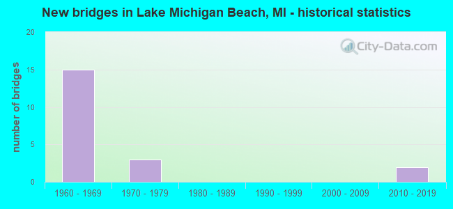
- New bridges - historical statistics
- 151960-1969
- 31970-1979
- 22010-2019


- Bridge Condition - Deck
- 16.7%Good
- 75.0%Satisfactory
- 8.3%Fair

- Bridge Condition - Superstructure
- 8.3%Very good
- 8.3%Good
- 8.3%Satisfactory
- 75.0%Fair

- Bridge Condition - Substructure
- 8.3%Very good
- 16.7%Good
- 58.3%Satisfactory
- 8.3%Fair
- 8.3%Poor

- Bridge Condition - Channel
- 40.0%Satisfactory
- 60.0%Fair
Find on map >> Show street view
Structure Number: 919, Location: 5.0 MI NE BENTON HARBOR (Lat: 42.167147, Lng: -86.373425), Route carried "on" structure: Interstate 196, Year Built: 1963, Status: Open, Structure Length: 6.13m (20.11ft), Average Daily Traffic: 11,100 (year 2010), Truck Traffic: 32%, Average Future Daily Traffic: 14,900 (year 2030), Design Load: HS 20+Mod, Features Intersected: PAW PAW RIVER
Minimum Vertical Clearance: 30.48m (100.00ft), Kilometerpoint: 3.702, Lanes on structure: 2, Base Highway Network: Yes (Inventory Route: 136, Subroute: 6), Owner: State Highway Agency, Approaching Roadway Width: 12.3m (40.4ft), Material/Design: Steel, Design/Construction: Stringer/Multi-beam, Number Of Spans In Main Unit: 3, Length of Maximum Span: 20.4m (66.9ft), Curb-To-Curb Width: 12.2m (40.0ft), Out-to-Out Width: 13.2m (43.3ft)
Condition: Deck: Satisfactory, Superstructure: Fair, Substructure: Satisfactory, Channel: Fair, Operating Rating: 92.0 metric tons, Method Used To Determine Operating Rating: Load Factor (LF), Inventory Rating: 55.2 metric tons, Method Used To Determine Inventory Rating: Load Factor (LF), Structural Evaluation: Somewhat better than minimum adequacy, Deck Geometry: Better than present minimum criteria, Waterway Adequacy: Equal to present minimum criteria, Approach Roadway Alignment: Equal to present desirable criteria, Designated Inspection Frequency: Every 24 months, Underwater Inspection Frequency: Every 60 months, Inspection Date: July 2020, Underwater Inspection Date: June 2017, Deck Structure Type: Concrete Cast-file-Place, Wearing Surface/Protective System: Wearing Surface: Latex Concrete
Find on map >> Show street view
Structure Number: 92, Location: 5.0 MI NE BENTON HARBOR (Lat: 42.166861, Lng: -86.373289), Route carried "on" structure: Interstate 196, Year Built: 1963, Status: Open, Structure Length: 6.13m (20.11ft), Average Daily Traffic: 14,900 (year 2010), Truck Traffic: 32%, Average Future Daily Traffic: 10,730 (year 2018), Design Load: HS 20+Mod, Features Intersected: PAW PAW RIVER
Minimum Vertical Clearance: 30.48m (100.00ft), Kilometerpoint: 3.716, Lanes on structure: 2, Base Highway Network: Yes (Inventory Route: 136, Subroute: 5), Owner: State Highway Agency, Approaching Roadway Width: 12.1m (39.7ft), Material/Design: Steel, Design/Construction: Stringer/Multi-beam, Number Of Spans In Main Unit: 3, Length of Maximum Span: 20.4m (66.9ft), Curb-To-Curb Width: 12.2m (40.0ft), Out-to-Out Width: 13.2m (43.3ft)
Condition: Deck: Satisfactory, Superstructure: Fair, Substructure: Satisfactory, Channel: Fair, Operating Rating: 92.0 metric tons, Method Used To Determine Operating Rating: Load Factor (LF), Inventory Rating: 55.2 metric tons, Method Used To Determine Inventory Rating: Load Factor (LF), Structural Evaluation: Somewhat better than minimum adequacy, Deck Geometry: Better than present minimum criteria, Waterway Adequacy: Equal to present minimum criteria, Approach Roadway Alignment: Better than present minimum criteria, Designated Inspection Frequency: Every 24 months, Underwater Inspection Frequency: Every 60 months, Inspection Date: July 2020, Underwater Inspection Date: June 2017, Deck Structure Type: Concrete Cast-file-Place, Wearing Surface/Protective System: Wearing Surface: Latex Concrete
Find on map >> Show street view
Structure Number: 921, Location: IN RIVERSIDE (Lat: 42.184322, Lng: -86.377319), Route carried "on" structure: Interstate 196, Year Built: 1963, Year Reconstructed: 2011, Status: Open, Structure Length: 4.50m (14.76ft), Average Daily Traffic: 9,050 (year 2010), Truck Traffic: 2%, Average Future Daily Traffic: 10,730 (year 2018), Design Load: HS 20+Mod, Features Intersected: CSX RR
Minimum Vertical Clearance: 30.48m (100.00ft), Kilometerpoint: 5.691, Lanes on structure: 2, Base Highway Network: Yes (Inventory Route: 136, Subroute: 6), Owner: State Highway Agency, Approaching Roadway Width: 13.9m (45.6ft), Skew: 1 degrees, Material/Design: Steel, Design/Construction: Stringer/Multi-beam, Number Of Spans In Main Unit: 3, Length of Maximum Span: 14.9m (48.9ft), Curb-To-Curb Width: 12.2m (40.0ft), Out-to-Out Width: 13.2m (43.3ft)
Condition: Deck: Satisfactory, Superstructure: Fair, Substructure: Satisfactory, Operating Rating: 82.9 metric tons, Method Used To Determine Operating Rating: Load Factor (LF), Inventory Rating: 49.7 metric tons, Method Used To Determine Inventory Rating: Load Factor (LF), Structural Evaluation: Somewhat better than minimum adequacy, Deck Geometry: Better than present minimum criteria, Approach Roadway Alignment: Better than present minimum criteria, Designated Inspection Frequency: Every 24 months, Inspection Date: October 2020, Deck Structure Type: Concrete Cast-file-Place, Wearing Surface/Protective System: Wearing Surface: Latex Concrete
Find on map >> Show street view
Structure Number: 922, Location: IN RIVERSIDE (Lat: 42.184331, Lng: -86.377694), Route carried "on" structure: Interstate 196, Year Built: 1963, Year Reconstructed: 2011, Status: Open, Structure Length: 4.50m (14.76ft), Average Daily Traffic: 9,050 (year 2010), Truck Traffic: 2%, Average Future Daily Traffic: 10,730 (year 2018), Design Load: HS 20+Mod, Features Intersected: CSX RR
Minimum Vertical Clearance: 30.48m (100.00ft), Kilometerpoint: 5.720, Lanes on structure: 2, Base Highway Network: Yes (Inventory Route: 136, Subroute: 5), Owner: State Highway Agency, Approaching Roadway Width: 12.3m (40.4ft), Skew: 1 degrees, Material/Design: Steel, Design/Construction: Stringer/Multi-beam, Number Of Spans In Main Unit: 3, Length of Maximum Span: 14.9m (48.9ft), Curb-To-Curb Width: 12.2m (40.0ft), Out-to-Out Width: 13.2m (43.3ft)
Condition: Deck: Satisfactory, Superstructure: Fair, Substructure: Satisfactory, Operating Rating: 67.7 metric tons, Method Used To Determine Operating Rating: Load Factor (LF) rating reported by rating factor (RF) method using MS18 loading, Inventory Rating: 40.5 metric tons, Method Used To Determine Inventory Rating: Load Factor (LF) rating reported by rating factor (RF) method using MS18 loading, Structural Evaluation: Somewhat better than minimum adequacy, Deck Geometry: Better than present minimum criteria, Approach Roadway Alignment: Better than present minimum criteria, Designated Inspection Frequency: Every 24 months, Inspection Date: October 2020, Deck Structure Type: Concrete Cast-file-Place, Wearing Surface/Protective System: Wearing Surface: Latex Concrete
Find on map >> Show street view
Structure Number: 926, Location: 1.5 MI N OF I-94 (Lat: 42.164119, Lng: -86.371867), Route carried "on" structure: County highway , Year Built: 1962, Status: Open, Structure Length: 6.49m (21.29ft), Average Daily Traffic: 1,632 (year 1996), Truck Traffic: 3%, Average Future Daily Traffic: 1,877 (year 2016), Design Load: H 15, Features Intersected: I-196, Facility Carried by Structure: SCHMUHL ROAD
Minimum Vertical Clearance: 30.48m (100.00ft), Kilometerpoint: 1.006, Lanes on structure: 2, Lanes under structure: 4, Owner: State Highway Agency, Approaching Roadway Width: 6.7m (22.0ft), Material/Design: Prestressed concrete, Design/Construction: Stringer/Multi-beam, Number Of Spans In Main Unit: 4, Length of Maximum Span: 21.6m (70.9ft), Curb or Sidewalk Widths: Left: 0.8m (2.6ft), Right: 0.8m (2.6ft), Curb-To-Curb Width: 7.3m (24.0ft), Out-to-Out Width: 9.4m (30.8ft)
Condition: Deck: Good, Superstructure: Satisfactory, Substructure: Satisfactory, Operating Rating: 44.4 metric tons, Method Used To Determine Operating Rating: Load Factor (LF) rating reported by rating factor (RF) method using MS18 loading, Inventory Rating: 26.6 metric tons, Method Used To Determine Inventory Rating: Load Factor (LF) rating reported by rating factor (RF) method using MS18 loading, Structural Evaluation: Equal to present minimum criteria, Deck Geometry: Meets minimum limits, Underclear: Meets minimum limits, Approach Roadway Alignment: Better than present minimum criteria, Designated Inspection Frequency: Every 24 months, Inspection Date: October 2020, Deck Structure Type: Concrete Cast-file-Place, Wearing Surface/Protective System: Wearing Surface: Monolithic Concrete
Find on map >> Show street view
Structure Number: 927, Location: IN RIVERSIDE (Lat: 42.186314, Lng: -86.376739), Route carried "on" structure: Interstate 196, Year Built: 1963, Year Reconstructed: 2011, Status: Open, Structure Length: 3.77m (12.37ft), Average Daily Traffic: 10,651 (year 2007), Truck Traffic: 34%, Average Future Daily Traffic: 9,881 (year 2018), Design Load: HS 20+Mod, Features Intersected: COLOMA ROAD
Minimum Vertical Clearance: 30.48m (100.00ft), Kilometerpoint: 5.918, Lanes on structure: 3, Lanes under structure: 3, Base Highway Network: Yes (Inventory Route: 136, Subroute: 6), Owner: State Highway Agency, Approaching Roadway Width: 15.8m (51.8ft), Skew: 1 degrees, Material/Design: Steel, Design/Construction: Stringer/Multi-beam, Number Of Spans In Main Unit: 3, Length of Maximum Span: 15.8m (51.8ft), Curb-To-Curb Width: 14.7m (48.2ft), Out-to-Out Width: 15.7m (51.5ft)
Condition: Deck: Satisfactory, Superstructure: Fair, Substructure: Good, Operating Rating: 70.3 metric tons, Method Used To Determine Operating Rating: Load Factor (LF) rating reported by rating factor (RF) method using MS18 loading, Inventory Rating: 42.1 metric tons, Method Used To Determine Inventory Rating: Load Factor (LF) rating reported by rating factor (RF) method using MS18 loading, Structural Evaluation: Somewhat better than minimum adequacy, Deck Geometry: Meets minimum limits, Underclear: Somewhat better than minimum adequacy, Approach Roadway Alignment: Better than present minimum criteria, Designated Inspection Frequency: Every 24 months, Inspection Date: October 2020, Deck Structure Type: Concrete Cast-file-Place, Wearing Surface/Protective System: Wearing Surface: Latex Concrete
Find on map >> Show street view
Structure Number: 928, Location: IN RIVERSIDE (Lat: 42.186314, Lng: -86.377106), Route carried "on" structure: Interstate 196, Year Built: 1963, Year Reconstructed: 2011, Status: Open, Structure Length: 3.77m (12.37ft), Average Daily Traffic: 10,651 (year 2007), Truck Traffic: 34%, Average Future Daily Traffic: 9,881 (year 2018), Design Load: HS 20+Mod, Features Intersected: COLOMA ROAD
Minimum Vertical Clearance: 30.48m (100.00ft), Kilometerpoint: 5.945, Lanes on structure: 3, Lanes under structure: 3, Base Highway Network: Yes (Inventory Route: 136, Subroute: 5), Owner: State Highway Agency, Approaching Roadway Width: 13.9m (45.6ft), Skew: 1 degrees, Material/Design: Steel, Design/Construction: Stringer/Multi-beam, Number Of Spans In Main Unit: 3, Length of Maximum Span: 15.8m (51.8ft), Curb-To-Curb Width: 14.7m (48.2ft), Out-to-Out Width: 15.7m (51.5ft)
Condition: Deck: Satisfactory, Superstructure: Fair, Substructure: Good, Operating Rating: 70.3 metric tons, Method Used To Determine Operating Rating: Load Factor (LF) rating reported by rating factor (RF) method using MS18 loading, Inventory Rating: 42.1 metric tons, Method Used To Determine Inventory Rating: Load Factor (LF) rating reported by rating factor (RF) method using MS18 loading, Structural Evaluation: Somewhat better than minimum adequacy, Deck Geometry: Meets minimum limits, Underclear: Somewhat better than minimum adequacy, Approach Roadway Alignment: Better than present minimum criteria, Designated Inspection Frequency: Every 24 months, Inspection Date: October 2020, Deck Structure Type: Concrete Cast-file-Place, Wearing Surface/Protective System: Wearing Surface: Latex Concrete
Find on map >> Show street view
Structure Number: 929, Location: 0.5 MI N OF RIVERSIDE (Lat: 42.195847, Lng: -86.373897), Route carried "on" structure: County highway , Year Built: 1963, Status: Open, Structure Length: 8.08m (26.51ft), Average Daily Traffic: 894 (year 1984), Truck Traffic: 3%, Average Future Daily Traffic: 1,028 (year 2004), Design Load: H 15, Features Intersected: I-196, Facility Carried by Structure: RIVERSIDE ROAD
Minimum Vertical Clearance: 30.48m (100.00ft), Kilometerpoint: 1.728, Lanes on structure: 2, Lanes under structure: 4, Owner: State Highway Agency, Approaching Roadway Width: 6.7m (22.0ft), Skew: 3 degrees, Material/Design: Steel, Design/Construction: Stringer/Multi-beam, Number Of Spans In Main Unit: 4, Length of Maximum Span: 26.7m (87.6ft), Curb or Sidewalk Widths: Left: 0.8m (2.6ft), Right: 0.8m (2.6ft), Curb-To-Curb Width: 7.9m (25.9ft), Out-to-Out Width: 10.0m (32.8ft)
Condition: Deck: Satisfactory, Superstructure: Fair, Substructure: Satisfactory, Operating Rating: 52.8 metric tons, Method Used To Determine Operating Rating: Load Factor (LF) rating reported by rating factor (RF) method using MS18 loading, Inventory Rating: 31.8 metric tons, Method Used To Determine Inventory Rating: Load Factor (LF) rating reported by rating factor (RF) method using MS18 loading, Structural Evaluation: Somewhat better than minimum adequacy, Deck Geometry: Somewhat better than minimum adequacy, Underclear: High priority of corrective action, Approach Roadway Alignment: Better than present minimum criteria, Designated Inspection Frequency: Every 24 months, Inspection Date: October 2020, Bridge Improvement Cost: $152,000, Deck Structure Type: Concrete Cast-file-Place, Wearing Surface/Protective System: Wearing Surface: Monolithic Concrete
Find on map >> Show street view
Structure Number: 93, Location: 2.5 MI N OF RIVERSIDE (Lat: 42.219022, Lng: -86.365278), Route carried "on" structure: County highway , Year Built: 1962, Status: Open, Structure Length: 7.10m (23.29ft), Average Daily Traffic: 290 (year 2007), Average Future Daily Traffic: 319 (year 2022), Design Load: H 15, Features Intersected: I-196, Facility Carried by Structure: CENTRAL AVE
Minimum Vertical Clearance: 30.48m (100.00ft), Kilometerpoint: 1.711, Lanes on structure: 2, Lanes under structure: 4, Owner: State Highway Agency, Approaching Roadway Width: 6.7m (22.0ft), Skew: 2 degrees, Material/Design: Steel, Design/Construction: Stringer/Multi-beam, Number Of Spans In Main Unit: 4, Length of Maximum Span: 22.5m (73.8ft), Curb or Sidewalk Widths: Left: 0.8m (2.6ft), Right: 0.8m (2.6ft), Curb-To-Curb Width: 7.3m (24.0ft), Out-to-Out Width: 9.4m (30.8ft)
Condition: Deck: Satisfactory, Superstructure: Fair, Substructure: Satisfactory, Operating Rating: 56.7 metric tons, Method Used To Determine Operating Rating: Load Factor (LF) rating reported by rating factor (RF) method using MS18 loading, Inventory Rating: 33.7 metric tons, Method Used To Determine Inventory Rating: Load Factor (LF) rating reported by rating factor (RF) method using MS18 loading, Structural Evaluation: Somewhat better than minimum adequacy, Deck Geometry: Somewhat better than minimum adequacy, Underclear: Meets minimum limits, Approach Roadway Alignment: Equal to present desirable criteria, Designated Inspection Frequency: Every 24 months, Other Special Inspection Frequency: Every 24 months, Inspection Date: October 2020, Other Special Inspection Date: October 2021, Deck Structure Type: Concrete Cast-file-Place, Wearing Surface/Protective System: Wearing Surface: Monolithic Concrete
Find on map >> Show street view
Structure Number: 931, Location: 3.0 MI N OF RIVERSIDE (Lat: 42.229733, Lng: -86.365239), Route carried "on" structure: State highway 63, Year Built: 2019, Status: Open, Structure Length: 6.16m (20.21ft), Average Daily Traffic: 2,635 (year 2018), Truck Traffic: 3%, Average Future Daily Traffic: 3,100 (year 2039), Design Load: Greater than HL93, Features Intersected: I-196
Minimum Vertical Clearance: 30.48m (100.00ft), Kilometerpoint: 0.333, Lanes on structure: 2, Lanes under structure: 4, Base Highway Network: Yes (Inventory Route: 136, Subroute: 1), Owner: State Highway Agency, Approaching Roadway Width: 13.4m (44.0ft), Material/Design: Prestressed concrete, Design/Construction: Stringer/Multi-beam, Number Of Spans In Main Unit: 2, Length of Maximum Span: 30.1m (98.8ft), Curb-To-Curb Width: 13.4m (44.0ft), Out-to-Out Width: 14.4m (47.2ft)
Condition: Deck: Good, Superstructure: Very good, Substructure: Very good, Operating Rating: 51.5 metric tons, Method Used To Determine Operating Rating: Load and Resistance Factor Rating (LRFR) rating reported by rating factor(RF) method using HL-93 loadings, Inventory Rating: 40.2 metric tons, Method Used To Determine Inventory Rating: Load and Resistance Factor Rating (LRFR) rating reported by rating factor(RF) method using HL-93 loadings, Structural Evaluation: Equal to present desirable criteria, Deck Geometry: Better than present minimum criteria, Underclear: Somewhat better than minimum adequacy, Approach Roadway Alignment: Better than present minimum criteria, Designated Inspection Frequency: Every 24 months, Inspection Date: October 2020, Bridge Improvement Cost: $99,000, Deck Structure Type: Concrete Cast-file-Place, Wearing Surface/Protective System: Wearing Surface: Monolithic Concrete, Deck Protection: Epoxy Coated Reinforcing
Find on map >> Show street view
Structure Number: 1014, Location: 2.0 MI NW OF COLOMA (Lat: 42.198036, Lng: -86.341967), Route carried "on" structure: County highway , Year Built: 1978, Status: Posted for load, Structure Length: 3.99m (13.09ft), Average Daily Traffic: 611 (year 2007), Truck Traffic: 4%, Average Future Daily Traffic: 900 (year 2027), Design Load: H 20, Features Intersected: PAW PAW RIVER, Facility Carried by Structure: BUNDY ROAD
Minimum Vertical Clearance: 30.48m (100.00ft), Kilometerpoint: 1.408, Lanes on structure: 2, Owner: County Highway Agency, Approaching Roadway Width: 9.8m (32.2ft), Material/Design: Prestressed concrete, Design/Construction: Stringer/Multi-beam, Number Of Spans In Main Unit: 3, Length of Maximum Span: 12.8m (42.0ft), Curb-To-Curb Width: 9.8m (32.2ft), Out-to-Out Width: 11.1m (36.4ft)
Condition: Deck: Satisfactory, Superstructure: Good, Substructure: Fair, Channel: Satisfactory, Operating Rating: 40.5 metric tons, Method Used To Determine Operating Rating: Load Factor (LF) rating reported by rating factor (RF) method using MS18 loading, Inventory Rating: 24.3 metric tons, Method Used To Determine Inventory Rating: Load Factor (LF) rating reported by rating factor (RF) method using MS18 loading, Structural Evaluation: Somewhat better than minimum adequacy, Deck Geometry: Equal to present minimum criteria, Waterway Adequacy: Equal to present desirable criteria, Approach Roadway Alignment: Equal to present minimum criteria, Bridge Posting: Required (Relationship of Operating Rating to Maximum Legal Load: 10.0 - 19.9% below), Designated Inspection Frequency: Every 24 months, Underwater Inspection Frequency: Every 60 months, Inspection Date: July 2020, Underwater Inspection Date: June 2018, Deck Structure Type: Concrete Cast-file-Place, Wearing Surface/Protective System: Wearing Surface: Monolithic Concrete
Find on map >> Show street view
Structure Number: 10765, Location: 0.2 MI EAST OF 82ND ST (Lat: 42.243036, Lng: -86.337186), Route carried "on" structure: County highway , Year Built: 1972, Status: Posted for load, Structure Length: 0.67m (2.20ft), Average Daily Traffic: 309 (year 2003), Average Future Daily Traffic: 455 (year 2024), Features Intersected: ROGERS CREEK, Facility Carried by Structure: 48TH AVENUE
Minimum Vertical Clearance: 30.48m (100.00ft), Kilometerpoint: 0.259, Lanes on structure: 2, Owner: County Highway Agency, Approaching Roadway Width: 11.0m (36.1ft), Material/Design: Wood or Timber, Design/Construction: Slab, Number Of Spans In Main Unit: 1, Length of Maximum Span: 6.4m (21.0ft), Curb-To-Curb Width: 8.5m (27.9ft), Out-to-Out Width: 9.2m (30.2ft)
Condition: Deck: Fair, Superstructure: Fair, Substructure: Poor, Channel: Satisfactory, Operating Rating: 38.6 metric tons, Method Used To Determine Operating Rating: Allowable Stress (AS) rating reported by rating factor (RF) method using MS18 loading, Inventory Rating: 27.2 metric tons, Method Used To Determine Inventory Rating: Allowable Stress (AS) rating reported by rating factor (RF) method using MS18 loading, Structural Evaluation: Meets minimum limits, Deck Geometry: Equal to present minimum criteria, Waterway Adequacy: Equal to present desirable criteria, Approach Roadway Alignment: Better than present minimum criteria, Bridge Posting: Required (Relationship of Operating Rating to Maximum Legal Load: > 39.9% below), Designated Inspection Frequency: Every 12 months, Inspection Date: April 2021, Deck Structure Type: Wood or Timber, Wearing Surface/Protective System: Wearing Surface: Bituminous
Find on map >> Show street view
Structure Number: 14357, Location: 50 FT S OF 46TH AVE (Lat: 42.250300, Lng: -86.339400), Route carried "on" structure: County highway , Year Built: 1970, Status: Open, Structure Length: 0.77m (2.53ft), Average Daily Traffic: 93 (year 2015), Average Future Daily Traffic: 107 (year 2035), Features Intersected: ROGERS CREEK, Facility Carried by Structure: 82ND ST
Minimum Vertical Clearance: 30.48m (100.00ft), Kilometerpoint: 0.840, Lanes on structure: 2, Owner: County Highway Agency, Approaching Roadway Width: 8.5m (27.9ft), Skew: 1 degrees, Material/Design: Steel, Design/Construction: Culvert, Number Of Spans In Main Unit: 3, Length of Maximum Span: 2.3m (7.5ft)
Condition: Channel: Fair, Culverts: Poor, Operating Rating: 92.7 metric tons, Method Used To Determine Operating Rating: Load Factor (LF) rating reported by rating factor (RF) method using MS18 loading, Inventory Rating: 55.4 metric tons, Method Used To Determine Inventory Rating: Load Factor (LF) rating reported by rating factor (RF) method using MS18 loading, Structural Evaluation: Meets minimum limits, Waterway Adequacy: Equal to present minimum criteria, Approach Roadway Alignment: Meets minimum limits, Designated Inspection Frequency: Every 12 months, Inspection Date: April 2021, Wearing Surface/Protective System: Wearing Surface: Bituminous
Find on map >> Show street view
Structure Number: 926, Location: 1.5 MI N OF I-94 (Lat: 42.164119, Lng: -86.371867), Route carried "under" structure: Interstate 196, Year Built: 1962, Structure Length: 0. m, Average Daily Traffic: 21,302 (year 2007), Truck Traffic: 32%, Features Intersected: I-196, Facility Carried by Structure: SCHMUHL ROAD
Minimum Vertical Clearance: 5.08m (16.67ft), Kilometerpoint: 3.341, Lanes on structure: 2, Lanes under structure: 4, Material/Design: Prestressed concrete, Design/Construction: Stringer/Multi-beam, Length of Maximum Span: 21.6m (70.9ft)
Find on map >> Show street view
Structure Number: 927, Location: IN RIVERSIDE (Lat: 42.186314, Lng: -86.376739), Route carried "under" structure: County highway 1182, Year Built: 1963, Structure Length: 0. m, Average Daily Traffic: 4,176 (year 1992), Truck Traffic: 14%, Features Intersected: COLOMA ROAD, Facility Carried by Structure: I-196 NB
Minimum Vertical Clearance: 4.47m (14.67ft), Kilometerpoint: 2.683, Lanes on structure: 3, Lanes under structure: 3, Material/Design: Steel, Design/Construction: Stringer/Multi-beam, Length of Maximum Span: 15.8m (51.8ft)
Find on map >> Show street view
Structure Number: 928, Location: IN RIVERSIDE (Lat: 42.186314, Lng: -86.377106), Route carried "under" structure: County highway 1182, Year Built: 1963, Structure Length: 0. m, Average Daily Traffic: 4,176 (year 1992), Truck Traffic: 3%, Features Intersected: COLOMA ROAD, Facility Carried by Structure: I-196 SB
Minimum Vertical Clearance: 4.62m (15.16ft), Kilometerpoint: 2.652, Lanes on structure: 3, Lanes under structure: 3, Material/Design: Steel, Design/Construction: Stringer/Multi-beam, Length of Maximum Span: 15.8m (51.8ft)
Find on map >> Show street view
Structure Number: 929, Location: 0.5 MI N OF RIVERSIDE (Lat: 42.195847, Lng: -86.373897), Route carried "under" structure: Interstate 196, Year Built: 1963, Structure Length: 0. m, Average Daily Traffic: 19,070 (year 2014), Truck Traffic: 25%, Features Intersected: I-196, Facility Carried by Structure: RIVERSIDE ROAD
Minimum Vertical Clearance: 5.11m (16.77ft), Kilometerpoint: 7.001, Lanes on structure: 2, Lanes under structure: 4, Material/Design: Steel, Design/Construction: Stringer/Multi-beam, Length of Maximum Span: 26.7m (87.6ft)
Find on map >> Show street view
Structure Number: 93, Location: 2.5 MI N OF RIVERSIDE (Lat: 42.219022, Lng: -86.365278), Route carried "under" structure: Interstate 196, Year Built: 1962, Structure Length: 0. m, Average Daily Traffic: 18,602 (year 2007), Truck Traffic: 34%, Features Intersected: I-196, Facility Carried by Structure: CENTRAL AVE
Minimum Vertical Clearance: 5.33m (17.49ft), Kilometerpoint: 9.674, Lanes on structure: 2, Lanes under structure: 4, Material/Design: Steel, Design/Construction: Stringer/Multi-beam, Length of Maximum Span: 22.5m (73.8ft)
Find on map >> Show street view
Structure Number: 931, Location: 3.0 MI N OF RIVERSIDE (Lat: 42.229733, Lng: -86.365239), Route carried "under" structure: Interstate 196, Year Built: 2019, Structure Length: 0. m, Average Daily Traffic: 21,335 (year 2018), Truck Traffic: 23%, Features Intersected: I-196, Facility Carried by Structure: M-63
Minimum Vertical Clearance: 5.05m (16.57ft), Kilometerpoint: 10.865, Lanes on structure: 2, Lanes under structure: 4, Material/Design: Prestressed concrete, Design/Construction: Stringer/Multi-beam, Length of Maximum Span: 30.1m (98.8ft)
Find on map >> Show street view
Structure Number: 10685, Location: 1.0 MI NE OF BERRIEN COL (Lat: 42.257664, Lng: -86.335664), Route carried "under" structure: Interstate 196, Year Built: 1963, Structure Length: 0. m, Average Daily Traffic: 18,500 (year 2010), Truck Traffic: 22%, Features Intersected: I-196, Facility Carried by Structure: 44 TH AVE (CR376)
Minimum Vertical Clearance: 5.11m (16.77ft), Kilometerpoint: 2.120, Lanes on structure: 2, Lanes under structure: 4, Material/Design: Prestressed concrete, Design/Construction: Stringer/Multi-beam, Length of Maximum Span: 22.1m (72.5ft)